var Tamilnaduplaces =
{
menusystembengali :
" "+
"এই পাতার জায়গাসমূহঃ-"+
"মেনু দেখতে ক্লিক করুন"+
" •মুখবন্ধ"+
" •হোগেনাক্কল "+
" •ইয়ারকার্ড"+
" •কোটাগিরি"+
" •উটি-কুন্নুর "+
" •মুডুমালাই"+
" •কোয়াম্বটোর"+
" •কোডাইকানাল "+
" •কন্যাকুমারী"+
" •মাদুরাই"+
" •রামেশ্বরম "+
" •তিরুচিরাপল্লী"+
" •নার্থামালাই"+
" •থিরুমায়াম "+
" •পুডুকোট্টাই"+
" •কড়াইকুডি"+
" •তাঞ্জোর "+
" •ট্রাঙ্কুবার"+
" •ভেলানকান্নাই"+
" •গঙ্গাইকোণ্ডাচোলাপুরম "+
" •চিদমব্রম"+
" •পারাঙ্গিপেট্টাই"+
" •তিরুভান্নামালাই "+
" •গিঞ্জি"+
" •পণ্ডিচেরী"+
" •ইয়ালাগিরি "+
" •ভেলোর"+
" •মহাবলীপূরম"+
" •কাঞ্চিপূরম "+
" •চেন্নাই"+
" •কোম্বাকোনম"+
" •সাইলেন্ট-ভ্যালি "+
" •পাইকারা-লেক",
menusystemenglish :
" "+
"Places in This Page:-"+
"Click To See Menu"+
" •Prelude"+
" •Hegenakkal "+
" •Yarcard"+
" •Kotagiri"+
" •Ooty-Coonoor "+
" •Mudumalai"+
" •Coimbator"+
" •Kodaikanal "+
" •Kanyakumari"+
" •Madurai"+
" •Rameshwaram "+
" •Tiruchirapally"+
" •Narthmalai"+
" •Thirumayam "+
" •Pudukkottai"+
" •Karaikudi"+
" •Tanjore "+
" •Tranqubar"+
" •Velankannai"+
" •Gangaikondacholapuram "+
" •Chidambram"+
" •Parangipettai"+
" •Tiruvannamalai "+
" •Gingee"+
" •Pondicherry"+
" •Yalagiri "+
" •Vellore"+
" •Mahabalipuram"+
" •Kanchipuram "+
" •Chennai"+
" •Kombakkanam"+
" •Silent-Valley "+
" •Paika-Lake",
tamilnaduintrobengali : "তামিলনাডু মুখবন্ধঃ-তামিলনাডুকে বলা হয় মন্দিরের দেশ। তা স্বত্বেও এই রাজ্য ভারতের মধ্যে যথেষ্ট প্রগতিশীল রাজ্য হিসাবে চিহ্নিত। দাক্ষিণাত্যের মালভূমির দক্ষিণপূর্ব থেকে পূর্বে করমণ্ডলের উপকূলরেখা অব্ধি বিস্তৃত এই রাজ্যে রয়েছে প্রচুর কর্মব্যস্ত উজ্জ্বল শহর, আকর্ষণীয় ছোট ছোট জনপদ, শান্ত বেলাভূমি, অনুচ্চ পাহাড়, বন্যপ্রাণী সমৃদ্ধ নীলগিরির সবুজ জঙ্গল আর আছে ইতিহাস ও প্রত্নতাত্ত্বিক সম্পদের এক উন্নতমানের দ্রষ্টব্য। ইতিহাস সিক্ত তামিলনাডু দক্ষিণ ভারতের এক প্রতিনিধিত্বকারী রাজ্য, যেখানে রয়েছে স্মরণাতীত কাল থেকে বিভিন্নভাবে তৈরি হওয়া উন্নতমানের দ্রাবিড় সংস্কৃতি যার মৌলিক উপাদান আজও অপরিবর্তিত। আধুনিক তামিলনাডুতে রয়েছে ছোট বড় তথ্যপ্রযুক্তি শিল্প, আধুনিক সেচ, বিদ্যুৎ প্রকল্প ও বিশ্বমানের শিক্ষাপ্রতিষ্ঠান। এইসব আধুনিক মন্দিরের পাশাপাশি রয়েছে ঐতিহ্যপূর্ণ পুরোনো মন্দিরের এক বিশাল সম্ভার। আর তাই তামিলনাডু দেশের মধ্যে বাণিজ্য, বিজ্ঞান ও চিকিৎসার সাথে সাথে পর্যটন ক্ষেতেও এক অগ্রণী ভূমিকা পালন করছে। রয়েছে পশ্চিমঘাট পর্বতমালার রাজকীয় পাহাড় থেকে করমণ্ডল উপকূলের চমকপ্রদ বেলাভূমি। এই রাজ্যেই দেখা যায় তিন সাগরের মিলনস্থল আর ভারতের শেষ বিন্দু। তামিল মানুষজনের আতিথেয়তা তো বিশ্বে একটা প্রতীক হিসাবে চিহ্নিত। বিস্তীর্ণ এই ভূখণ্ডে এত বিভিন্নতা রয়েছে যে কোনটা সর্বোত্তম তা নির্ণয় করা সত্যিই খুব কঠিন। ইতিহাস-যদিও তামিলনাডু ভারতের সবথেকে প্রাচীন অঞ্চল, কিন্তু ইতিহাসের আলোকে আসে খৃষ্টপূর্ব চতুর্থ শতাব্দী থেকে। সঙ্গম সাহিত্য থেকে তখনকার মানুষের সামাজিক, অর্থনৈতিক ও ধর্মীয় রীতিনীতি জানা যায়। তামিলনাডুতে বিভিন্ন সময়ে চেরা, চোলা ও পাণ্ডা রাজারা রাজত্ব করেন। প্রথম চোলা রাজবংশের সর্বোত্তম রাজা হলেন করিকলান চোলা। তিনি বহু সমাজকল্যাণমূলক কাজ করেছেন যার মধ্যে কাবেরি নদীর ওপর বাঁধ উল্লেখযোগ্য। গুরুত্বপূর্ণ চোলা শহরগুলো হল তাঞ্জাভুর ও কোম্বাকোনম। চোলা রাজত্ব আসে চেরা রাজত্বের পরে ও শেষকালে আসে পল্লব রাজবংশ। এই পর্বকে বলা হয় সঙ্গম পর্ব যা তামিল সাহিত্যের ক্লাসিক্যাল পর্যায় বলে অবিহিত। এই সময়েই তৈরি হয় ছন্দময় কবিতা, রোমান্টিক মহাকাব্য ও নান্দনিক ভাস্কর্যশৈলী। তাঁরা প্রচুর শহর ও জনপদও তৈরি করেন। পাণ্ডা রাজত্বকালের বিখ্যাত শহর হ'ল মাদুরাই। দ্রাবিড় স্থাপত্যশৈলী শ্রেষ্ঠত্বের শিখরে ওঠে পাণ্ডা রাজত্বকালেই। বিখ্যাত সৃষ্টির মধ্যে রয়েছে মহাবলীপূরম, কাঞ্চিপূরম এবং চেন্নাইয়ে কপিলেশ্বর ও পার্থসারথি মন্দির ইত্যাদি। পাণ্ডা রাজত্বের সবথেকে বিখ্যাত রাজা ছিলেন অত্যন্ত সাহসী যোদ্ধা রাজস্মা নরসিমাভ্রম পল্লব। ইনি চালুক্যের রাজা দ্বিতীয় পুলকেশীর আক্রমণ প্রতিহত করেন। এই তিন রাজত্বের প্রত্যেক পর্যায়েই অনেক লক্ষণীয় কাজ হয়েছে তবু চোলা রাজত্বকে বিশেষভাবে চিহ্নিত করা হয় কারণ তাঁদের সময়েই তামিল ধ্যানধারণার নির্যাস-পুনর্জন্ম, কর্ম ও যোগচর্চার মতো মতাদর্শের প্রচার করা হয় সুদূর কম্বোডিয়া, ভিয়েতনাম ও ইন্দোনেশিয়ায়। তাঁরা শ্রীলঙ্কা, লাক্ষাদ্বীপ এবং ইন্দোনেশিয়ার সুমাত্রা ও জাভা দখল করে দক্ষিণপূর্ব এশিয়ায় চোলা রাজবংশের ভিত্তি স্থাপন করে যান। চতুর্দশ শতাব্দীতে মুসলিম আক্রমণের পর চোলা রাজবংশের পতন হয় ও দক্ষিণ ভারতের স্বাধীন মুসলিম বহমানি সম্রাটরা ১৫৬৪ সাল অব্ধি ক্ষমতা দখল করে রাখে। দাক্ষিণাত্যের সুলতানদের কাছে তালিকোটার যুদ্ধে বহমানি সম্রাট পরাজিত হয়। জয়ী সুলতানরা পরিকল্পিতভাবে বিজয়নগর শহর ধ্বংস করে ও পরাজিত বহমানি সম্রাটরা তখন বহু দূরে পালিয়ে যায়। মোঘলরা পুরোপুরি ভারতবর্ষ কব্জা করার আগেই ১৬৪১ সালে ব্রিটিশ ইষ্ট ইণ্ডিয়া কোম্পানি চুক্তি করে চেন্নাপট্টিনাম বা বর্তমান চেন্নাইয়ের বন্দরে তাদের উপনিবেশ স্থাপন করে। কিন্তু তারা চুক্তি ভঙ্গ ও প্রতারণা করে ১৮৫৭ সালে ক্ষমতা দখল করে। তবে ফরাসি, ডাচ ও ডেনিশরাও এই এলাকায় ব্যবসা করতে চাওয়ার ফলে এক অশান্তির বাতাবরণ সৃষ্টি হয় কিন্তু শেষ অব্ধি ব্রিটিশরাই তাদের আধিপত্য বজায় রাখে। ব্রিটিশরা এই এলাকার নাম দেয় মাদ্রাজ। স্বাধীনতার পর ১৪ জানুয়ারি ১৯৬৯ সালে মাদ্রাজ নাম বদলে তামিলনাডু করা হয়। "+
"Read More..."+
"
"+
"শব্দঃ প্রতিবেদনঃ "+
""+
"ভিডিও"+
"স্লাইডশোর জন্যে নীচের ছবিতে ক্লিক করুন "+
"
"+
"পেজ মেনুতে যান",
tamilnaduintroenglish : "Tamilnadu Introduction:-Tamil Nadu is called the land of temples. Nevertheless, this state is marked as a sufficiently progressive state in India. The state stretches from the southeast of the Deccan Plateau to the coastline of the Coromandel, where there is a busy dazzling metropolitan, attractive small towns, tranquil seashores, small hills, animal enriched green forest of Nilgiri and the rich reference of history and archeological treasures. Historically, Tamil Nadu is one of the representative states of South India that has been created in various ways of Dravidian culture since time immemorial, the basic elements of which are still intact today. Modern Tamil Nadu has small and large IT industries, modern irrigation, power projects and world class educational institutions. In addition to these modern temples, there is a huge collection of traditional old temples. And so Tamil Nadu is playing a leading role in the field of trade, science and medicine as well as tourism in the country. There are also spectacular beaches on the Coromandel coast and the royal hills of the Western Ghats. This state is the meeting point of the three oceans and the last point of India. The hospitality of the Tamil people is marked as a symbol in the world. There is so much variety in this vast terrain that it is really difficult to determine which is the best.History:-Although Tamil Nadu is the oldest region of India, the light of history comes from the 4th century BC. The social, economic and religious customs of the people of that time are known from Sangam literature. The Chera, Chola and Panda kings ruled at different times in Tamil Nadu. The best king of the first Chola dynasty was Karikalan Chola. He has done a lot of social welfare work, most notably the dam on the river Kaberi. Important Chola cities are Thanjavur and Kombakonam. The Chola kingdom came after the Chera kingdom and finally the Pallab dynasty. This episode is called Sangam episode which is known as the classical stage of Tamil literature. Rhythmic poems, romantic epics and aesthetic sculptures were created during this time. They also built many cities and towns. Madurai was a famous city during the reign of Panda. Dravidian architecture reached its peak during the Panda reign. Famous creations include Mahabalipuram, Kanchipuram and Kapileshwar and Parthasarathi temples in Chennai. The most famous king of the Panda kingdom was the very brave warrior Rajsma Narasimhavram Pallab. He resisted the invasion of Pulkeshi II, the king of the Chalukyas. The Chola dynasty is distinguished by the fact that in their time ideologies such as the essence of Tamil meditation, reincarnation, action and yoga were propagated in distant Cambodia, Vietnam and Indonesia. They conquered Sri Lanka, Lakshadweep and Sumatra and Java in Indonesia and laid the foundation of the Chola dynasty in Southeast Asia. After the Muslim invasion in the 14th century, the Chola dynasty ended and the independent Muslim Bahmani emperors of South India held power till 1564. The Bahmani emperor was defeated at the battle of Talikota by the sultans of the Deccan. The victorious sultans systematically destroyed the city of Vijayanagar and the defeated Bahmani emperors fled far away. Before the Mughals completely occupied India, in 1641, the British East India Company made a treaty and established their colony at Chennapattinam or present-day port of Chennai. But they broke the treaty and seized power in 1857. However, the French, Dutch and Danes also wanted to do business in the area, which created an atmosphere of unrest, but the British maintained their dominance until the end. The British named this area Madras. After independence, on 14 January 1969, Madras was renamed Tamil Nadu. "+
"Read More..."+
"
"+
"Sound Stream: "+
""+
"Video"+
"Click any Picture for Slide Show "+
"
"+
"Go To Page Menu",
phototamilnaduintro :
""+
" "+
" "+
" "+
" "+
" "+
" "+
" "+
""+
"",
hegenakkalbengali : "হোগেনাক্কলঃ-তামিলনাডুর ধরমপুরি জেলার হোগেনাক্কাল জলপ্রপাত কাবেরি নদীর ওপর এক জলপ্রপাত যা পবিত্র ও প্রশান্ত পরিবেশের মধ্যে অবস্থান করছে। হোগেনাক্কাল শব্দের অর্থ ধূমায়িত পাথর। এই জলপ্রপাত তামিলনাডু ও কর্ণাটক উভয় রাজ্যের মানুষের কাছে অত্যন্ত পবিত্র। একে অনেকে ভারতের নায়গ্রা বলে তবে তা একটু বাড়াবাড়ি বলে মনে হয় যদিও আমরা একটুও জল পাইনি তাই তা পরখ করার সুযোগ ছিল না। আবার এই হোগেনাক্কাল নিয়েই চূড়ান্ত বিরোধ ও বিতর্ক রয়েছে দুই রাজ্যের মধ্যে। তামিলনাডু ও কর্ণাটক এই দুই দেশের মধ্যে যৌথ পানীয় জল প্রকল্প করা হয়েছিল ২০০৮ সালে যাতে প্রায় চল্লিশ লক্ষ মানুষ উপকৃত হ’ত। কাবেরি নদীর জল নিয়ে দুই দেশের মধ্যে বিবাদ বহু পুরোনো। মহীশুরের রাজা ও ব্রিটিশ শাসিত মাদ্রাজ প্রেসিডেন্সির মধ্যেও কাবেরি নদীর জল নিয়ে বিরোধ ছিল। পরবর্তীকালে ভারতীয় জলসম্পদ বিষয়ক মন্ত্রকের হস্তক্ষেপে দু-রাজ্যের মধ্যে আলোচনা হয় ও জলসমস্যা নিয়ে কিছু সুনির্দিষ্ট নীতি ঠিক করা হয়। তাতে দু-রাজ্যের মানুষেরই অনেক সুবিধা হবে। কিন্তু কর্ণাটক হাইকোর্টে মামলার দরুন তা আপাতত স্থগিত রাখা হয়েছে। অর্থাৎ গোটা সমস্যাটা যে তিমিরে ছিল সেই তিমিরেই রয়ে গেল। কাবেরি নদীর জলকে কেন্দ্র করে জল ছাড়াও কর্ণাটক ও তামিলনাডুর মধ্যে বহু ব্যাপারে চরম বিরোধ দেখা যায় যা সাধারণ মানুষের মধ্যেও সংক্রমিত হয়েছে। "+
"Read More..."+
"
"+
"শব্দঃ প্রতিবেদনঃ "+
""+
"ভিডিও"+
"স্লাইডশোর জন্যে নীচের ছবিতে ক্লিক করুন "+
"
"+
"পেজ মেনুতে যান",
hegenakkalenglish : "Hegenakkal:-Hogenakkal Falls in Dharampuri District, Tamil Nadu is a waterfall located on the Kaveri River in a sacred and serene environment. The word Hogenakkal means smoky stone. This waterfall is very sacred to the people of both the states of Tamil Nadu and Karnataka. Many people call it Niagara of India but it seems a bit exaggerated even though we didn't get any water so we didn't have a chance to compare it. Again, there is a exterme dispute between the two states over this Hogenakkal. A joint drinking water project was launched between Tamil Nadu and Karnataka in 2008 to benefit about four million people. The dispute between the two states over the waters of the Kaberi River is very old. There was also a dispute between the king of Mysore and the British-ruled Madras Presidency over the waters of the Kaberi River. Subsequently, with the intervention of the Indian Ministry of Water Resources, discussions were held between the two states and some specific policies on water issues were fixed. It will benefit the people of the two states. But it has been stayed for the time being due to a case in the Karnataka High Court. That is, the whole problem remained in dark as was previously. Apart from the water centered on the Kaveri River, there are extreme disputes between Karnataka and Tamil Nadu over many issues which have also infected the common people. "+
"Read More..."+ "
"+
"Sound Stream: "+
""+
"Video"+
"Click any Picture for Slide Show "+
"
"+
"Go To Page Menu",
photohegenakkal :
""+
" "+
" "+
" "+
" "+
" "+
" "+
" "+
""+
"",
yarcardbengali : "ইয়ারকার্ডঃ-সবুজ বনাঞ্চল জড়িয়ে থাকা সুবিস্তৃত পর্বতমালা আর বিস্ময়কর নৈসর্গিক শোভা। সাথে আছে ছোট ছোট জলপ্রপাত, বিন্দুর মতো ছড়িয়ে ছটিয়ে থাকা ঘুমন্ত গ্রাম আর সনাতনী ঐতিহ্যে সংপৃক্ত মন্দির, চার্চ ও অন্যান্য সৌধ। এই হচ্ছে ইয়ারকার্ডের মূল আকর্ষণী ক্ষমতা। তামিলনাডুর সালাম জেলার মুগ্ধ করা এই জনপদ শুধুমাত্র সদ্য বিবাহিত দম্পতির রোমান্সের জায়গা নয়, যারা প্রকৃতি প্রেমিক বা শুধুমাত্র অলসভাবে কিছুটা সময় কাটাতে চায় তাদের জন্যও। বা বলা যেতে পারে তামিলনাডু ভ্রমণার্থী সকল মানুষের জন্যই ইয়ারকার্ড এক আদর্শ ভ্রমণ ঠিকানা। ইষ্টার্নঘাট পর্বতমালার শেভোরয় রেঞ্জের একটা অংশে ইয়ারকার্ড অবস্থিত যেখানে বহু রকমের পদযাত্রা করা সম্ভব। প্রাকৃতিক সৌন্দর্যে পরিপূর্ণ ইয়ারকার্ডে রয়েছে বহু ধরনের উদ্ভিদ ও প্রাণীর প্রাচুর্য যা এই সম্মোহিত করা স্বপ্নালু জনপদকে করেছে আকর্ষণের কেন্দ্রবিন্দু। এই পাহাড়ি জনপদ প্রায় একশো বছর ধরে তার হেরিটেজ ধরে রেখেছে। সেই অতীত যুগের স্বাদ আস্বাদন করতে হলে ঘুরতে হবে লুপ রোডে। স্থানীয় আদিবাসী মানুষজনের আতিথেয়তা, তাদের খাদ্য, ভাষা ও জীবনধারা, ধর্ম, প্রথা সবাইকে মুগ্ধ করবেই। ভাষা না বুঝলেও সুগন্ধি কফি দিয়ে সবাইকে আপ্যায়ন করা, গ্রামের মানুষজনের একটা পুরানো রীতি। "+
"Read More..."+
"
"+
"শব্দঃ প্রতিবেদনঃ "+
""+
"ভিডিও"+
"স্লাইডশোর জন্যে নীচের ছবিতে ক্লিক করুন "+
"
"+
"পেজ মেনুতে যান",
yarcardenglish : "Yarcard:-Yarcard has extensive mountains and wonderful natural beauty surrounded by green forests. There are small waterfalls, dotted sleeping villages and temples, churches and other monuments associated with the traditional heritage. This is the main attraction of Yarcard. This fascinating town in Tamil Nadu's Salam district is not only a place for newlyweds to romance, but also for those who love nature or just want to spend some time lazily. Or it can be said that Yarcard is an ideal travel address for all the people traveling to Tamil Nadu. Yarkard is located in a part of the Sevoroi Range in the Eastern Ghats where a variety of trekking is possible. Yarcard, full of natural beauty, has an abundance of flora and fauna which has made this mesmerizing dreamy town the center of attraction. This hill station has retained its heritage for almost a hundred years. If you want to taste that past era, you have to go around Loop Road. The hospitality of the indigenous people, their food, language, the way of life, religion and customs will impress everyone. Even if they don't understand your language, entertaining everyone with fragrant coffee is an old custom of the villagers. "+
"Read More..."+
"
"+
"Sound Stream: "+
""+
"Video"+
"Click any Picture for Slide Show "+
"
"+ "Go To Page Menu",
photoyarcard :
""+
" "+
" "+
" "+
" "+
" "+
" "+
" "+
""+
"",
kotagiribengali : "কোটাগিরিঃ-কোটাগিরি নামটা এসেছে কোটাকেরি থেকে, স্থানীয় ভাষায় যার অর্থ কোটাদের রাস্তা। এই জনপদ একসময় কোটা উপজাতিদের ছিল, যারা নীলগিরি পর্বতের আদিমতম উপজাতি বলে স্বীকৃত। যখন উটি যাবার জন্যে পাহাড়ি রাস্তা তৈরি হয়নি তখন সমস্ত গাড়িকে মেট্টুপালায়াম থেকে কোটাগিরি হয়ে উটি কুন্নুর যেতে হতো। কোটাগিরি, প্রাকৃতিক সৌন্দর্যে পরিপূর্ণ। এটা শান্ত, সবুজ ও নিষ্কলুষীত পরিবেশে তৈরি হওয়া একটা জনপদ যা অলস-ভাবে অবকাশ যাপনের এক সুন্দর ঠিকানা। এখানে অনেক সুন্দর সুন্দর ট্রেকিং রুট আছে যা অ্যাডভেঞ্চারপ্রিয় মানুষদের আকর্ষণ করে। কোটাগিরির চা বাগানের সৌন্দর্য সত্যিই ভোলার নয়। নীল আকাশের নীচে সবুজ চা বাগানের ভেতর দিয়ে ছোট্ট গাড়ির রাস্তা আর ছড়িয়ে ছিটিয়ে থাকা আদিবাসীদের ঘুমন্ত গ্রাম সবাইকে মুগ্ধ করবেই। লংউড শোলা কোটাগিরির কাছে এক বিচ্ছিন্ন হয়ে থাকা ক্রান্তীয় চিরসবুজ অরণ্য। যদিও খরচ একটু বেশি তবু লংউড শোলাতে একরাত্রি থাকলে তা হয়ে যাবে জীবনের একটা অন্যতম প্রাপ্তি। কোলাহলহীন পরিবেশে সূর্যোদয় থেকে সূর্যাস্ত দেখার সাথে সাথে পাওয়া যাবে উড়ন্ত শিয়াল, বাইসন, অনেক ধরনের পাখি ও দুষ্প্রাপ্য কিছু উদ্ভিদ। কোটাগিরি তামিলনাডু ভ্রমণে এক অবশ্য দর্শনীয় ঠিকানা। "+
"Read More..."+
"
"+
"শব্দঃ প্রতিবেদনঃ "+
""+
"ভিডিও"+
"স্লাইডশোর জন্যে নীচের ছবিতে ক্লিক করুন "+
"
"+
"পেজ মেনুতে যান",
kotagirienglish : "Kotagiri:-The name Kotagiri comes from Kotakeri, which in the local language means the road to Kotas. The town once belonged to the Kota tribe, who are recognized as the earliest tribes of the Nilgiris. When the hilly road to Ooty was not paved, all vehicles had to go from Mettupalayam to Ooty Kunnur via Kotagiri. Kotagiri, full of natural beauty. It is a town built in a quiet, green and untainted environment which is a beautiful place for leisurely vacation. There are many beautiful trekking routes here, that attract adventurous people. The beauty of Kotagiri tea garden is really not forgettable. Under the blue sky, through the green tea garden, the road of small cars and the scattered indigenous sleeping villages will fascinate everyone. An isolated tropical evergreen forest Longwood Shola near Kotagiri. Even if the cost is a bit high, staying overnight in Longwood Shola will be one of the achievements of life. Flying foxes, bison, many kinds of birds and some rare plants can be found from sunrise to sunset in a quiet environment. Kotagiri is a must visit destination in Tamil Nadu. "+
"Read More..."+ "
"+
"Sound Stream: "+
""+
"Video"+
"Click any Picture for Slide Show "+
"
"+
"Go To Page Menu",
photokotagiri :
""+
" "+
" "+
" "+
" "+
" "+
" "+
" "+
""+
"",
ooticoonoorbengali : "উটি ও কুন্নুরঃ-উটি বা উটাকমাণ্ড নীলগিরি জেলার একটা পাহাড়ি জনপদ। ভ্রমণার্থী ও পর্যটকদের জন্যে এটা অত্যন্ত জনপ্রিয় পর্যটন কেন্দ্র। জনপদটা মূলতঃ টোডা উপজাতি অধ্যুষিত এলাকা হলেও এখানে কোটা, বাডাগা ও কুরুম্বা উপজাতিদের অস্তিত্বও রয়েছে। তাদের জীবিকা প্রধানত পর্যটন ও চাষ-আবাদ। অষ্টাদশ শতাব্দীতে ব্রিটিশ ইষ্ট ইণ্ডিয়া কোম্পানি উটি দখল করে। এখানে অনেক ঔষধের ও এক সময়ে ফটোগ্রাফারদের হৃদয় জয় করা ইন্দু ফিল্মের কারখানা আছে। প্রাকৃতিক সৌন্দর্যের আকর্ষণ ও ঠাণ্ডা পরিবেশের জন্যে উটিতে অনেক পর্যটকের সমাগম হয়, বিশেষতঃ গ্রীষ্মকালে। উটাকমাণ্ড কথাটা কোথা থেকে এসেছে সেটা জানা যায়নি তবে ১৮২১ সালে মাদ্রাজ গেজেটে এই রকম একটা নাম পাওয়া যায়। তামিল সাহিত্য অনুযায়ী দ্বিতীয় শতাব্দীতে চেরা রাজা সেঙ্গুট্টুভান হিমালয়ের দিকে যাত্রা করার সময় এখানে রাজত্ব করেন। চেরা, গঙ্গা, কাদম্ব, রাষ্ট্রকুটা, চোলা, বিজয়নগরের রাজা ইত্যাদি রাজারা নীলগিরি রাজত্ব করেন। টিপু সুলতান নীলগিরি ব্রিটিশদের হাতে ছেড়ে দেন ১৭৯৯ সালে। কোয়াম্বাটোরের কালেক্টর জন সুলিভানের সহায়ক এন কিনডার্সলে নীলগিরি পরিদর্শন করে এক রিপোর্ট দেন। তার বর্ণনায় এই এলাকায় রয়েছে অসাধারণ ঝোরা-ঝর্ণা ও প্রচুর নদীপ্রবাহ যা ঘন সবুজ পরিবেশের মধ্যে লুকিয়ে আছে, আর সুন্দর সুন্দর সবুজ উপত্যকা এলাকার শ্রী বৃদ্ধি করেছে। এই অঞ্চল ইউরোপের যে কোনও জায়গার থেকে কম কিছু নয় ও সুইজারল্যান্ডের সঙ্গে তুলনীয়। এই রিপোর্ট পাবার পর ১৮২৩ সালে রাস্তা তৈরি হয় যা ১৮৩২ সালে কুন্নুর অব্দি বিস্তৃত হয়েছিল। "+
"Read More..."+
"
"+
"শব্দঃ প্রতিবেদনঃ "+
""+
"ভিডিও"+
"স্লাইডশোর জন্যে নীচের ছবিতে ক্লিক করুন "+
"
"+
"পেজ মেনুতে যান",
ooticoonoorenglish : "Ooty & Coonoor:- Ooty or Utakmand is a hill station in the Nilgiris district. It is a very popular tourist destination for travelers and tourists alike. Although the town is originally inhabited by the Toda tribe, the Kota, Badaga and Kurumba tribes also exist here. Their livelihood is mainly tourism and farming. Ooty was occupied by the British East India Company in the 18th century. There are factories of many medicines and Indu films, that won the hearts of photographers at one time. Ooty attracts a lot of tourists, especially in summer, for its natural beauty and cool environment. It is not known where from the word Utakmand came, but such a name appeared in the Madras Gazette in 1821. According to Tamil literature, the Chera king Senguttuvan reigned here in the 2nd century, on his way to the Himalayas. The kings of Chera, Ganga, Kadamba, Rashtrakuta, Chola, Vijayanagar etc. ruled Nilgiri. Tipu Sultan handed over Nilgiris to the British in 1799. Ann Kindersley, an aide to Coimbatore collector John Sullivan, visited the Nilgiris and gave a report. According to him, the area has remarkable waterfalls and abundant river flows that are hidden in the dense green environment, and the beautiful green valley area has increased its beauty. This region is no less than anywhere else in Europe and is comparable to Switzerland. After receiving this report, the road was constructed in 1823 which was extended to Kunnur in 1832. "+
"Read More..."+
"
"+
"Sound Stream: "+
""+
"Video"+
"Click any Picture for Slide Show "+
"
"+
"Go To Page Menu",
photoooticoonoor :
""+
" "+
" "+
" "+
" "+
" "+
" "+
" "+
""+
"",
mudumalaibengali : "মুডুমালাইঃ-কেরালা, কর্ণাটক ও তামিলনাডুর এই তিন রাজ্যের সংযোগস্থলে অবস্থিত মুডুমালাই সারা দেশের মধ্যে একটা অন্যতম গুরুত্বপূর্ণ এবং অনন্য সুন্দর অভয়ারণ্য। ৩২১ স্কো. কি.মি. অঞ্চল পরিবৃত এই অভয়ারণ্যে রয়েছে প্রচুর স্পটেড ডিয়ার, হাতি, বাইসন, বাঘ, চিতাবাঘ, ভালুক, কালো চিতা, বনবেড়াল, বেজি, কৃষ্ণসার মৃগ, শিয়াল, বাঁদর ও অন্যান্য জীবজন্তু। আদিম পিঁপড়ে খাওয়া প্যাঙ্গোলিন একমাত্র এখানেই পাওয়া যায়। এখানকার পক্ষী সাম্রাজ্যের বিস্তৃতিও নেহাত কম নয়। পাইকারা লেক উটি থেকে মাত্র ১৯ কি.মি. দূরে অবস্থিত। পাইকারা নদী টোডা উপজাতিদের কাছে অত্যন্ত পবিত্র নদী হিসাবে বিবেচিত। মুকুরতি পর্বতমালা থেকে বেরিয়ে উত্তরদিকে প্রবাহিত হয়ে মালভূমির কিনারায় এসে তার প্রবাহ পশ্চিমদিকে চলমান। এই নদীতে প্রচুর ছোট বড় জলপ্রপাত আছে যার মধ্যে ৫৫ মিটার ও ৬১ মিটার উচ্চ জলপ্রপাতকে পাইকারা ফলস বলে। এই এলাকায় টোডা উপজাতিদের বাস ও অনেক রকমের বন্যপ্রাণী রয়েছে। "+
"Read More..."+
"
"+
"শব্দঃ প্রতিবেদনঃ "+
""+
"ভিডিও"+
"স্লাইডশোর জন্যে নীচের ছবিতে ক্লিক করুন "+
"
"+
"পেজ মেনুতে যান",
mudumalaienglish : "Mudumalai:-Mudumalai, located at the junction of the three states of Kerala, Karnataka and Tamil Nadu, is one of the most important and uniquely beautiful sanctuaries in the country. 321 Square Km surrounding the area, the sanctuary is rich in spotted deer, elephants, bison, tigers, leopards, bears, black leopards, wild cats, mongoose, black deer, foxes, monkeys and other animals. Pangolin, Ant eater primitive Pangolin, is found only here. The expansion of the bird kingdom here is not less. Paikara lake is only 19 km from Ooty lake. The Paikara River is considered a very sacred river to the Toda tribes. Coming out of the Mukurti Mountains, It flows north to the edge of the plateau, and flows westward. The river has many small and large waterfalls, of which 55 meters and 61 meters high waterfalls are called Paikara falls. The area is home to the Toda tribes and there are wide variety of wildlife. "+
"Read More..."+
"
"+
"Sound Stream: "+
""+
"Video"+
"Click any Picture for Slide Show "+
"
"+
"Go To Page Menu",
photomudumalai :
""+
" "+
" "+
" "+
" "+
" "+
" "+
" "+
""+
"",
coimbatorbengali : "কোয়াম্বটোরঃ-পশ্চিম তামিলনাডুতে নীলগিরির পাদদেশে অবস্থিত কোয়াম্বাটোর জেলার সদর দপ্তর কোয়াম্বটোর শহর। এটা তামিলনাডুর তৃতীয় বৃহত্তম শহর। কোয়াম্বটোর তার কৃষিজ উৎপাদন ও স্বাস্থ্যকর জলবায়ুর জন্যে পরিচিত। এই শহর অত্যন্ত শিল্পায়িত, বিশেষতঃ বস্ত্রশিল্প, আর তাই জন্যে কোয়াম্বটোরকে দক্ষিণ ভারতের ম্যানচেস্টার বলে। এখানে প্রায় ১০০টার ওপর বস্ত্র কারখানা আছে যা প্রায় গোটা তামিলনাডুর বস্ত্র কারখানার অর্ধেক। এই জেলা তামিলনাডুর অত্যন্ত বর্ধিষ্ণু অঞ্চল। এখানে শাকসবজি, ধান, তুলো, চা, তৈলবীজ, সুপুরি, হলুদ, কফি ও তামাক চাষ হয়। কৃষি ও শিল্প সম্পদের প্রাচুর্য থাকা সত্যেও কোয়াম্বটোর কিন্তু তার প্রাচীন সংস্কৃতি ও সামাজিক রীতিনীতি মেনে চলে। এখানকার মানুষদের পারিবারিক বন্ধন অত্যন্ত মজবুত আর পরিবারের সমস্ত সদস্য তাদের পুরানো ঐতিহ্য ও সনাতনী প্রথা মেনে চলে। শিল্পশহর হলেও এখানকার প্রাকৃতিক দৃশ্যাবলীও যথেষ্ট মনোরম। পাহাড়ি অরণ্যে দেখা পাওয়া যায় অজস্র ঝোরা-ঝর্ণা, জীবজন্তু ও আদিবাসীদের জীবনযাত্রা সাথে ইতিহাস ও ঐতিহ্য সংপৃক্ত অনেক পুরানো মন্দির। "+
"Read More..."+
"
"+
"শব্দঃ প্রতিবেদনঃ "+
""+
"ভিডিও"+
"স্লাইডশোর জন্যে নীচের ছবিতে ক্লিক করুন "+
"
"+
"পেজ মেনুতে যান",
coimbatorenglish : "Coimbatore:-Coimbatore is the district headquarters of Coimbatore, located at the foothills of the Nilgiris in western Tamil Nadu. It is the third largest city in Tamil Nadu. Coimbatore is known for its agricultural production and healthy climate. The city is highly industrialized, especially the textile industry, which is why Coimbatore is called the Manchester of South India. There are about 100 textile factories here which is almost half of the entire textile factory in Tamil Nadu. This district is the most developed region of Tamil Nadu. Here vegetables, paddy, cotton, tea, oilseeds, betel nut, turmeric, coffee and tobacco are cultivated. Despite its abundance of agricultural and industrial resources, Coimbatore adheres to its ancient culture and social customs. The family bonds of the people here are very strong and all the family members follow their old traditions and customs. Although it is an industrial city, the natural scenery here is also quite beautiful. In the hilly forest you can find many old temples with many springs, animals and the life of the indigenous people. "+
"Read More..."+
"
"+
"Sound Stream: "+
""+
"Video"+
"Click any Picture for Slide Show "+
"
"+
"Go To Page Menu",
photocoimbator :
""+
" "+
" "+
" "+
" "+
" "+
" "+
" "+
""+
"",
kodaikanalbengali : "কোদাইকানালঃ-তামিলনাডুর ডিণ্ডিগুল জেলায় অবস্থিত একটা সুন্দর পাহাড়ি শহর কোদাইকানাল। তামিল ভাষায় এর অর্থ–জঙ্গলের দান। পালানি পাহাড়ের মুকুট হচ্ছে কোদাইকানাল। পুরো এলাকাটা ঘন জঙ্গল দিয়ে ঘেরা ও তাই অনেক সময় এই জনপদকে পাহাড়ি অঞ্চলের রাণী বলা হয় যার অনেক ইতিহাস এই জনপ্রিয় পর্যটন শহরের সঙ্গে যুক্ত। কোদাইকানালের পুরানো বাসিন্দা হ'ল পালি আদিবাসী গোষ্ঠি। তামিল সঙ্গম সাহিত্যে কোদাইকানালের নাম পাওয়া যায়। ১৮৪৫ সালে আধুনিক কোদাইকানাল প্রতিষ্ঠা করেন এক আমেরিকান খৃষ্টান মিশনারি ও ব্রিটিশ আমলারা। এদের কোদাইকানালে আসার প্রধান কারণ ছিল সমতলের তীব্র গরমে তাদের শরীরে তৈরি হওয়া ক্রান্তীয় রোগের হাত থেকে রেহাই পাওয়া। বিংশ শতাব্দীতে কিছু অভিজাত ভারতীয় এই সুন্দর জায়গাটার মর্ম উপলব্ধি করেন ও এখানে বসবাস শুরু করেন। পর্যটনের খানিকটা বিঘ্ন ঘটে যখন এখানে একটা ইউনিলিভারের ভারতীয় সহায়ক কোম্পানি হিন্দুস্থান ইউনিলিভার একটা পারদের কারখানা তৈরি করে। এ নিয়ে অনেক প্রতিবাদ প্রতিরোধ হলেও তেমন কিছু করা যায়নি। ২০১৫ সালে Kodaikanal Won’t নামে একটা RAP মিউজিক সারা দুনিয়ায় প্রতিবাদের ভাষা তৈরি করে ও চারদিনে প্রায় এক মিলিয়ন লোক তা শোনে। কিন্তু তা সত্যেও এখনও অব্দি পারদ পরিষ্কার করার কোনও সুনির্দিষ্ট কর্মসূচি নেওয়া হয়নি। "+
"Read More..."+
"
"+
"শব্দঃ প্রতিবেদনঃ "+
""+
"ভিডিও"+
"স্লাইডশোর জন্যে নীচের ছবিতে ক্লিক করুন "+
"
"+
"পেজ মেনুতে যান",
kodaikanalenglish : "Kodaikanal:-Kodaikanal is a beautiful hill town located in the Dindigul district of Tamil Nadu. In Tamil, it means the gift of the forest. Kodaikanal is the crown of Palani hills. The whole area is surrounded by dense jungles and hence this town is often called the queen of the hilly region with a lot of history associated with this popular tourist city. The oldest inhabitants of Kodaikanal are the Pali tribes. The name Kodaikanal is found in Tamil Sangam literature. The modern Kodaikanal was founded in 1845 by an American Christian missionary and British bureaucrat. The main reason for their coming to Kodaikanal was to get relief from the tropical disease that had formed in their body in the intense heat of the plains. In the twentieth century, some elite Indians realized the meaning of this beautiful place and started living here. Tourism was somewhat disrupted when Hindustan Unilever, an Indian subsidiary of Unilever, set up a mercury factory here. Although many protests and resistance were organised, nothing much could be done. In 2015, a rap music called Kodaikanal Won’t created a language of protest around the world and was heard by nearly one million people in four days. But in spite of that, no specific program has been taken to clear the mercury so far. "+
"Read More..."+
"
"+
"Sound Stream: "+
""+
"Video"+
"Click any Picture for Slide Show "+
"
"+
"Go To Page Menu",
photokodaikanal :
""+
" "+
" "+
" "+
" "+
" "+
" "+
" "+
""+
"",
kanyakumaribengali : "কন্যাকুমারীঃ-কন্যাকুমারী, জলবেষ্টিত ভারতের শেষ জনপদ। এই জনপদের মহিমা তার সূর্যোদয় ও সূর্যাস্তের জন্যে। আর তা অদ্বিতীয় কারণ এখানেই রয়েছে ভারত মহাসাগর, আরব সাগর আর বঙ্গোপসাগরের সঙ্গমস্থল। এটা ভারতের সেই বিন্দু যেখানে পূর্ণচন্দ্রিমায় একই সাথে সূর্যাস্ত ও চন্দ্রোদয় দেখা যায়। কন্যাকুমারী শুধু তামিলনাডুর শেষ জেলা নয় ভারতেরও শেষ স্থানাঙ্ক যার সদর দপ্তর রয়েছে ২২ কি.মি. দূরের নাগেরকোয়েলে। কন্যাকুমারীকে ঘিরে রেখেছে রাজকীয় পাহাড়ের শ্রেণী আর সমতলে রয়েছে রঙবেরঙের সমুদ্রসৈকত যার আঁচলে রয়েছে নকশি করা শাড়ির মতো নারকোল গাছ ও ধানক্ষেতের সবুজ প্রাঙ্গণ। পাহাড়ের শ্রেণী ও সমতলের মধ্যে রয়েছে, এখানে সেখানে ছড়িয়ে ছিটিয়ে থাকা ছোট ছোট অনুচ্চ পাহাড়ের লাল ক্লিফ, তরঙ্গায়িত উপত্যকা ও বিচিত্র সমুদ্রসৈকতের সঙ্গে ঠাস বুননে জড়িয়ে আছে মন্দির, গির্জা ও অন্যান্য সৌধ। এখানকার মানুষজন সহজ সরল এবং ধার্মিক হলেও তামিলনাডুতে সবথেকে শিক্ষিত জেলার খেতাব কন্যাকুমারীই অর্জন করেছে। "+
"Read More..."+
"
"+
"শব্দঃ প্রতিবেদনঃ "+
""+
"ভিডিও"+
"স্লাইডশোর জন্যে নীচের ছবিতে ক্লিক করুন "+
"
"+
"পেজ মেনুতে যান",
kanyakumarienglish : "Kanyakumari:-Kanyakumari, the last town in waterlogged India. The glory of this town is due to its sunrise and sunset. And that is unique because it is the confluence of the Indian Ocean, the Arabian Sea and the Bay of Bengal. This is the point in India where sunset and the moonrise can be seen at the same time in a full moon day. Kanyakumari is not only the last district of Tamil Nadu but also the last co-ordinate of India which has its headquartered at Nagercoil, 22 km from Kanyakumari city. Kanyakumari is surrounded by a range of majestic hills, and on the plains have colorful beaches, surrounded by Saree-like coconut trees and lush green courtyards. Temples, churches and other monuments are intertwined with the red cliffs of small low hills scattered here and there, undulating valleys and diverse beaches. Although the people here are simple and pious, Kanyakumari has earned the title of the most educated district in Tamil Nadu. "+
"Read More..."+
"
"+
"Sound Stream: "+
""+
"Video"+
"Click any Picture for Slide Show "+
"
"+
"Go To Page Menu",
photokanyakumari :
""+
" "+
" "+
" "+
" "+
" "+
" "+
" "+
""+
"",
maduraibengali : "মাদুরাইঃ-ভাগাই নদীর তীরে অবস্থিত মাদুরাই জেলার সদর দপ্তর মাদুরাই শহর। এটা তামিলনাডুর দ্বিতীয় বৃহত্তম শহর। এই শহর খৃষ্টপূর্ব তৃতীয় শতাব্দী থেকে বর্তমান ও তামিলনাডুর অন্যতম সাংস্কৃতিক ও বাণিজ্যিক কেন্দ্রস্থল। সঙ্গম সাহিত্য থেকে জানা যায় যে ৫৯০ সালে যখন পাণ্ডা রাজারা মাদুরাইয়ে তাঁদের রাজধানী স্থাপন করেছিলেন তখনও মাদুরাই দাক্ষিণাত্যের অন্যতম শহর হিসাবে স্বীকৃত ছিল। আধুনিক মাদুরাই দ্রুত বেড়ে উঠছে একটা শিল্পনগরী হিসাবে যদিও এখানে রয়েছে অনেক সবুজ ধানক্ষেতের বিস্তৃতি, ধুলাময় ঘিঞ্জি নগর জনপদ ও জনাকীর্ণ ব্যস্ত বাজার। মেগাস্থিনিস হয়ত এই শহরে এসেছিলেন খৃষ্টপূর্ব তৃতীয় শতকে যখন এই শহরকে মেথরা বলে উল্লেখ করেছেন যা উত্তর ভারতের মথুরার সমার্থক এবং যা তৎকালীন ময়ূরা রাজত্বের একটা বিশাল শহর ছিল। গ্রীক গণিতবিদ পি টেলমি তাঁর লেখায় মাদুরাইয়ের নাম করেন। প্রথমে কালাভ্রা রাজত্ব, পরে পাণ্ডা ও শেষকালে চোলা রাজত্বের রাজারা মাদুরাই রাজত্ব করেন এবং তা চলে প্রায় ত্রয়োদশ শতাব্দী অব্দি। পরবর্তীকালে মাদুরাই দিল্লীর সুলতানদের কব্জায় আসে। কিন্তু বিজয়নগরের স্বাধীন রাজারা ১৩৭৮ সালে মাদুরাই দখল করে। ১৫৫৯ সালে নায়েকরা মাদুরাই দখল করে ও ১৭৩৬ সাল অব্দি রাজত্ব করেন। তাঁরাই তৈরি করেন স্থাপত্যসমৃদ্ধ বিখ্যাত মীনাক্ষী মন্দির। অষ্টাদশ শতাব্দী অব্দি চন্দ সাহিব, কর্ণাটকের নবাব ও মহম্মদ ইউসুফ খান মাদুরাইয়ের ক্ষমতা দখল করেন। ১৮০১ সালে মাদুরাই পুরোপুরি ব্রিটিশদের দখলে আসে ও মাদ্রাজ প্রেসিডেন্সিতে অন্তর্ভুক্ত হয়। প্রথমদিকে তাঁরা মীনাক্ষী মন্দিরের জন্য অর্থ সাহায্য ও বিভিন্ন হিন্দু অনুষ্ঠানে অংশগ্রহণ করতেন। ঊনবিংশ ও বিংশ শতাব্দীতে মাদুরাই জেলা রাজনৈতিক ও শিল্পায়নের কেন্দ্রস্থল হিসাবে আত্মপ্রকাশ করে। ব্রিটিশরা ১৮৩৭ সালে মীনাক্ষী মন্দিরকে ঘিরে থাকা ফোর্টের দেওয়াল ভেঙ্গে দেয় ও ফোর্টের চতুর্দিকে একটা পরিখা তৈরি করে। ভাঙ্গা আবর্জনা দিয়ে নতুন রাস্তা তৈরি করে। মাদুরাইয়ে প্রথম মিউনিসিপ্যলিটি তৈরি হয় ১৮৬৬ সালে। "+
"Read More..."+
"
"+
"শব্দঃ প্রতিবেদনঃ "+
""+
"ভিডিও"+
"স্লাইডশোর জন্যে নীচের ছবিতে ক্লিক করুন "+
"
"+
"পেজ মেনুতে যান",
maduraienglish : "Madurai:-Madurai is the district headquarters of Madurai district, situated on the banks of the river Bhagai. It is the second largest city in Tamil Nadu. The city has been existing since the third century BC and is one of the cultural and commercial centers of Tamil Nadu. It is known from Sangam literature that Madurai was recognized as one of the cities of the Deccan even when the Panda kings established their capital at Madurai in 590 AD. Modern Madurai is fast growing as an industrial city, although it has a vast expanse of green paddy fields, dusty hilly towns and crowded bustling markets. Megasthenes may have come to this city in the 3rd century BC when he referred to the city as Methra which is synonymous with Mathura in northern India and which was a huge city in the then Mayura kingdom. The Greek mathematician Ptolemy named Madurai in his writings. Madurai reigned first in the Kalavra kingdom, then in the Panda and finally in the Chola kingdom, and lasted for about thirteen centuries. Later Madurai came under the control of the Sultans of Delhi. But the independent kings of Vijayanagar captured Madurai in 1378 AD. The Naiks occupied Madurai in 1559 and ruled till 1736. They built the famous Meenakshi temple rich in architecture. Up to eighteenth-century Chanda Sahib, Nawab of Karnataka and Muhammad Yusuf Khan seized power in Madurai. In 1801, Madurai was completely occupied by the British and became part of the Madras Presidency. In the beginning, they used to donate money for the Meenakshi temple and participate in various Hindu ceremonies. In the nineteenth and twentieth centuries, Madurai district emerged as a center of political and industrialization. The British demolished the fort wall surrounding the Meenakshi temple in 1837 and built a moat around the fort. Builds new roads with broken rubbish. The first municipality was formed in Madurai in 1866 AD. "+
"Read More..."+
"
"+
"Sound Stream: "+
""+
"Video"+
"Click any Picture for Slide Show "+
"
"+
"Go To Page Menu",
photomadurai :
""+
" "+
" "+
" "+
" "+
" "+
" "+
" "+
""+
"",
rameshwarambengali : "রামেশ্বরমঃ-রামেশ্বরম তামিলনাডুর রামনাথপুরম জেলায় অবস্থিত একটা ছোট্ট জনপদ। পামবন চ্যানেল দ্বারা মূল ভূখণ্ড থেকে বিচ্ছিন্ন হয়ে পামবন আইল্যান্ডে অবস্থিত রামেশ্বরম, শ্রীলঙ্কার মান্নার দ্বীপ থেকে মাত্র ৫০ কি.মি. দূরে অবস্থিত যা ভারতীয় পেনিনসুলার খুব কাছেই পড়ে। রামেশ্বরম হিন্দুদের কাছে এক অন্যতম পবিত্র তীর্থস্থান বলে বিবেচিত। লোককথা বলে যে সীতাকে রাবণের হাত থেকে উদ্ধার করার জন্যে ভগবান রাম সমুদ্রের ওপর দিয়ে ভারত থেকে শ্রীলঙ্কা অব্দি এক ব্রিজ তৈরি করেন। রামেশ্বরম শ্রীলঙ্কার এতই কাছে যে বিভিন্ন ভারতীয় মৎস্যজীবীদের, শ্রীলঙ্কার মিলিটারিদের দ্বারা বন্দী হওয়া প্রায় রোজের খবর। রামেশ্বরমের মূল জীবিকা মৎসশিকার ও পর্যটন। রামেশ্বরমে রামানাথস্বামী মন্দিরে রামের (বিষ্ণুর এক রূপ রাম) পুজো করা হয় ও মন্দিরটা সেই নামেই উৎসর্গ করা আছে। লোককথা অনুযায়ী ব্রাহ্মণ রাবণের সঙ্গে যুদ্ধ করার সময় যদি ব্রহ্মহত্যার কোনও পাপ হয়ে থাকে তা মুছে ব্রহ্মত্ব লাভ করার জন্যে, বিষ্ণুর সপ্তম অবতার রাম, বহু সন্ন্যাসীর পরামর্শে রামেশ্বরমে শিবের পুজো করতে শুরু করেন। এই শিবলিঙ্গ হিমালয় থেকে আনার জন্যে রাম তাঁর বানর সেনাপতি হনুমানকে আদেশ দেন। হনুমানের দেরির কারণে সীতা বালি দিয়ে এক শিবলিঙ্গ তৈরি করেন ও তা পূজা করা হয়। রামেশ্বরমের ইতিহাস রচিত হয় রামনাথস্বামী মন্দির ও একটা দ্বীপ নিয়ে যা ভারত ও শ্রীলঙ্কা যাবার একটা ট্রানজিট পয়েন্ট ছিল। চোলা রাজবংশের রাজা, রাজেন্দর চোলার এই জনপদের ওপর সাময়িক নিয়ন্ত্রণ ছিল। জাফনার রাজাদের রামেশ্বরমের সাথে ঘনিষ্ঠ যোগাযোগ ছিল ও নাম দিয়েছিলেন সেতুকভলন। যেহেতু জাফনার রাজার হিন্দু ছিলেন তাই রামশ্বরমের জন্য অনেক ব্যয় করতেন। রামেশ্বরমের সেতু তাঁদের কয়েনের খোদাই হিসাবে দৃশ্যমান ছিল। দিল্লীর সুলতানের সেনাপতি আলাউদ্দীন খিলিজী তাঁর সৈন্যদল নিয়ে রামেশ্বরমে পৌঁছান ধর্মীয় প্রচারের উদ্দেশ্যে। প্রচুর বাধা স্বত্বেও খিলিজী একটা মসজিদ তৈরি করেন ও ইসলামের জয় হিসাবে তার নাম দেয় আলিয়া-আল-দিন-খালদিজী। পঞ্চদশ শতাব্দীর প্রথম দিকে পুরো এলাকা পাণ্ডা রাজাদের আয়ত্তে আসে। ১৫২০ সালে বিজয়নগরের রাজাদের হাতে আসে ও তাঁরা রামেশ্বরমের মন্দিরের উন্নতির জন্যে অনেক ব্যয় করেন। পরবর্তীকালে কর্ণাটকের নবাব, মহম্মদ ইউসুফ খান ও অন্যান্য মুসলিম রাজারা বহুবার রামেশ্বরম আক্রমণ করেন ও দখল করেন। ১৭৯৫ সালে ব্রিটিশরা রামেশ্বরমের দখল নেয় ও ১৯৪৭ সাল অব্দি তা কায়েম রাখে। "+
"Read More..."+
"
"+
"শব্দঃ প্রতিবেদনঃ "+
""+
"ভিডিও"+
"স্লাইডশোর জন্যে নীচের ছবিতে ক্লিক করুন "+
"
"+
"পেজ মেনুতে যান",
rameshwaramenglish : "Rameshwaram:-Rameshwaram is a small town in Ramanathapuram district in the state of Tamil Nadu. Rameshwaram on Pamban Island, separated from the mainland by the Pamban Channel, is only 50 km from Manna Island in Sri Lanka falls very close to the Indian Peninsula. Rameshwaram is considered as one of the most sacred places of pilgrimage for Hindus. Folklore has it that Lord Rama built a bridge across the sea from India to Sri Lanka to rescue Sita from the hands of Ravana. Rameshwaram is so close to Sri Lanka that it is almost daily news that various Indian fishermen have been captured by the Sri Lankan military. The main livelihood of Rameshwaram is fishing and tourism. Rama (Rama is a form of Vishnu) is worshiped in the Ramanathaswamy temple at Rameshwaram and the temple is dedicated to that name. According to folklore, Rama, the seventh incarnation of Vishnu, started worshiping Shiva at Rameshwaram on the advice of many monks, in order to attain divinity by expunging any sin of Brahma-killing while fighting with Brahman Ravana. Rama ordered his monkey commander Hanuman to bring this Shivling from the Himalayas. Due to Hanuman's delay, Sita made a Shivling with sand and worshiped it. The history of Rameshwaram is based on the Ramanathaswamy Temple and an island which was a transit point to India and Sri Lanka. Rajendra Chola, king of the Chola dynasty, had temporary control over the town. The kings of Jaffna had close contact with Rameshwaram and named it Setukavalan. Since the king of Jaffna was a Hindu, he used to spend a lot for Ramaswaram. The bridge at Rameshwaram was visible as the engraving in their coins. Alauddin Khilji, the general of the Sultan of Delhi, arrived at Rameshwaram with his army for religious purposes. Despite many obstacles, Khilizi built a mosque and named it Alia-al-Din-Khaldiji means Conquest of Islam. The whole area came under the control of the Panda kings in the early fifteenth century. In 1520 it fell into the hands of the kings of Vijayanagar and they spent a lot for the improvement of the temple of Rameshwaram. Later, the Nawab of Karnataka, Muhammad Yusuf Khan and other Muslim kings repeatedly attacked and occupied Rameshwaram. The British occupied Rameshwaram in 1795 and maintained it till 1947. "+
"Read More..."+
"
"+
"Sound Stream: "+
""+
"video"+
"Click any Picture for Slide Show "+
"
"+
"Go To Page Menu",
photorameshwaram :
""+
" "+
" "+
" "+
" "+
" "+
" "+
" "+
""+
"",
trichibengali : "তিরুচিরাপল্লীঃ-কাবেরি নদীর তীরে অবস্থিত তিরুচিরাপল্লী বা ত্রিচি তামিলনাডুর চতুর্থ বৃহত্তম শহর। এই শহর বিখ্যাত হয়ে আছে তার উন্নত সংস্কৃতি, স্থাপত্য ও ঐতিহ্যের জন্যে ও এটা অবশ্যই তামিলনাডুর অন্যতম দর্শনীয় স্থান। কাবেরি নদীর ত্রিভুজের আগায় অবস্থিত সমভূমির দুদিকে রয়েছে শেভারয় ও পালানি পাহাড়। প্রত্নতাত্ত্বিক প্রমাণ, পুরানো ভারতীয় সাহিত্য ও টলেমির লেখা অনুযায়ী এই শহরের ইতিহাস তৈরি হয়েছে খৃষ্টপূর্ব ৩০০ সালে। এই শহর দেখেছে প্রথম চোলা, পল্লব, মধ্যযুগীয় চোলা, পাণ্ডব, মোঘল, বিদ্যানগরের রাজা, নায়েক, কর্ণাটকের নবাব ও শেষ অব্দি ব্রিটিশদের রাজত্ব। তিরুচিরাপল্লী তার শ্রেষ্ঠত্বের শিখরে উঠেছিল মাদুরাইয়ের নায়েকদের আমলে। শহরের রক ফোর্ট তৈরি ও শহর বিস্তার লাভ করেছিল সেই আমলেই। ত্রিচি দক্ষিণের একটা গুরুত্বপূর্ণ ব্যবসায়িক কেন্দ্র হয়ে উঠেছিল নায়েকদের আমলেই। ১৮০১ সালে ব্রিটিশ ইষ্ট ইণ্ডিয়া কোম্পানি তিরুচিরাপল্লী জেলা তৈরি করে তাদের রাজধানী হিসাবে ঘোষণা করে। জন ওয়ালেস তিরুচিরাপল্লী জেলার প্রথম কালেক্টরেট হয়েছিল। "+
"Read More..."+
"
"+
"শব্দঃ প্রতিবেদনঃ "+
""+
"ভিডিও"+
"স্লাইডশোর জন্যে নীচের ছবিতে ক্লিক করুন "+
"
"+
"পেজ মেনুতে যান",
trichienglish : "Tiruchirapally:-Tiruchirappalli or Trichy on the banks of the river Kaberi is the fourth largest city in Tamil Nadu. The city is famous for its rich culture, architecture and heritage and it is definitely one of the tourist sites in Tamil Nadu. The Sevaroi and Palani hills lie on either side of the plain at the head of the Kaberi River triangle. According to archeological evidence, ancient Indian literature and the writings of Ptolemy, the history of this city dates back to 300 BC. The city saw first Chola, Pallava, medieval Chola, Pandava, Mughal, Kings of Vidyanagar, Naik, Nawab of Karnataka and last British rule. Tiruchirappalli rose to the pinnacle of its excellence during the reign of the Naiks of Madurai. It was during this time that the city's rock fort was built and the city expanded. Trichy became an important business center in the south during the Naik period. In 1801, the British East India Company created Tiruchirappalli district and declared it as their capital. John Wallace became the first collectorate of Tiruchirappalli district. "+
"Read More..."+
"
"+
"Sound Stream: "+
""+
"Video"+
"Click any Picture for Slide Show "+
"
"+
"Go To Page Menu",
phototrichi :
""+
" "+
" "+
" "+
" "+
" "+
" "+
" "+
""+
"",
narthmalaibengali : "নার্থামালাইঃ-পডুকোট্টাই জেলার এক পঞ্চায়েত গ্রাম নার্থামালাইয়ের বিজয়ালিয়া চোলেশ্বরম মন্দির, শিব ভগবানের উদ্দেশ্যে উৎসর্গ করা আছে আর তা তৈরি হয়েছে পাথর খোদাই করে নাগারা গঠনশৈলীতে। মন্দিরটা নবম শতাব্দীতে পল্লব রাজবংশের মুট্টারাইয়ার রাজারা তৈরি করেন বলে মনে করা হয় ও পরবর্তীকালে তা সম্প্রসারণ করেন চোলা রাজারা। পাথরের খোদাই, চোলা রাজাদের চারুকলার এক অন্যতম নিদর্শন, ও সেই ঐতিহ্য শুরু হয়েছে পল্লব রাজাদের আমল থেকে। নার্থামালাইয়ের অন্য আকর্ষণ হচ্ছে অষ্টম শতাব্দীর একটা জৈন মন্দির আলুরুট্টিমালাই জৈন গুহা। এখানে আরও দুটো পাথরের খোদাই করা গুহা আছে যাতে প্রমাণ মাপের ১২ টা বিষ্ণুর মূর্তি আছে। এই মন্দির দক্ষিণ ভারতে সবথেকে পুরানো মন্দির বলে পরিচিত। "+
"Read More..."+
"
"+
"শব্দঃ প্রতিবেদনঃ "+
""+
"ভিডিও"+
"স্লাইডশোর জন্যে নীচের ছবিতে ক্লিক করুন "+
"
"+
"পেজ মেনুতে যান",
narthmalaienglish : "Narthmalai:-The Vijayalia Choleswaram temple at Northamalai, a panchayat village in Padukottai district, is dedicated to Lord Shiva and is built in the Nagara style of stone carving. The temple is believed to have been built by the Muttaraiya kings of the Pallab dynasty in the ninth century and was later expanded by the Chola kings. Stone carving is one of the fine art forms of the Chola kings, and that tradition started dates back to the time of the Pallab kings. Another attraction of Northamalai is the Aluruttimalai Jain Cave, an 8th century Jain temple. There are two more stone carved caves with 12 statues of Vishnu. This temple is known as the oldest temple in South India. "+
"Read More..."+
"
"+
"Sound Stream: "+
""+
"Video"+
"Click any Picture for Slide Show "+
"
"+ "Go To Page Menu",
photonarthmalai :
""+
" "+
" "+
" "+
" "+
" "+
" "+
" "+
""+
"",
thirumayambengali : "থিরুমায়ামঃ-পুডুকোট্টাই জেলার থিরুমায়াম জনপদের অন্যতম বিখ্যাত দর্শনীয় স্থান হচ্ছে থিরুমায়াম ফোর্ট। ১৬৮৭ সালে এটা তৈরি করেন রামনাদের রাজা বিজয় রঘুনাথ সেথুপথি। পরবর্তীকালে এই ফোর্ট তাঁর শ্যালক রঘুনাথ রায়া টণ্ডাইম্যানকে দিয়ে দেন। ফোর্টটা প্রাথমিক ভাবে তৈরি হয়েছিল একটা গোলাকার ফোর্ট হিসাবে যার সাতটা এককেন্দ্রিক গোলাকার দেওয়াল ছিল। সাতটার মধ্যে চারটে এখনও বেঁচে আছে। ফোর্টের গঠনশৈলী নিম্নমানের কারণ ছোট ছোট পাথরের খণ্ড ও ইট দিয়ে তৈরি করা হয়েছে যা ফোর্টের নিরাপত্তার জন্যে মোটেই ভালো নয়। উত্তর, দক্ষিণ ও পূর্বদিকে ফোর্টের তিনটে প্রবেশপথ রয়েছে। মন্দিরগুলোর মধ্যে হনুমান, শক্তি, গণপতি, কারুপ্পার রয়েছে দক্ষিণদিকে ও উত্তরদিকে রয়েছে ভৈরব মন্দির। একেবারে মাথায় রয়েছে ব্রিটিশ জমানার একটা কামান। এই প্ল্যাটফর্মের দক্ষিণে একটা প্রাকৃতিক জলাশয় ও দুটো পাথর খোদাই করা মন্দির রয়েছে যার মধ্যে একটা শিবের ও একটা বৈষ্ণবদের। মন্দির দুটো ঐতিহাসিক ও ধর্মীয় দিক থেকে যথেষ্ট গুরুত্বপূর্ণ। ১৭৯৯ সালে ব্রিটিশদের সঙ্গে প্রথম পলিগার যুদ্ধের সময় বিদ্রোহী কোট্টাবোমনের রাজা পঞ্চলানকুরুচ্চির ভাই ওমার্থুরাই এই ফোর্টে বন্দী হ’ন ও ব্রিটিশরা তাঁকে ফাঁসি দেয়। পরে ১৮০০ সালে আবার দ্বিতীয় পলিগার যুদ্ধ হয় ও ব্রিটিশদের প্রচুর ক্ষয়ক্ষতি হয়। ২০১২ সালে ভারতের প্রত্নতাত্ত্বিক বিভাগ ফোর্টের মধ্যে ব্যাপক সংস্কার কার্য চালায়। "+
"Read More..."+
"
"+
"শব্দঃ প্রতিবেদনঃ "+
""+
"ভিডিও"+
"স্লাইডশোর জন্যে নীচের ছবিতে ক্লিক করুন "+
"
"+
"পেজ মেনুতে যান",
thirumayamenglish : "Thirumayam:-Thirumayam Fort is one of the most famous places of interest in Thirumayam town of Pudukottai district. It was built in 1687 AD by Vijay Raghunath Sethupathi, the king of Ramnad. The fort was later handed over to his brother-in-law Raghunath Raya Tondaiman. The fort was originally built as a circular fort with seven concentric circular walls. Four of the seven are still alive. The reason for the low quality of the structure of the fort is that it is made of small pieces of stone and bricks which is not good for the security of the fort at all. The fort has three entrances to the north, south and east. Among the temples are Hanuman, Shakti, Ganapati, Karuppar to the south and Bhairab to the north. There is a cannon of the British era at its head. To the south of this platform is a natural reservoir and two stone carved temples, one for Shiva and one for Vaishnavism. The temple is important both historically and religiously. During the first Poligar war with the British in 1799, Omarthurai, brother of the rebellious King Panchalankuruchi of Kottaboman, was captured at the fort and hanged by the British. Later, in 1800, the Second Poligar War broke out and the British suffered heavy losses. In 2012, the Archaeological Survey of India carried out a major renovation of the fort. "+
"Read More..."+
"
"+
"Sound Stream: "+
""+
"Video"+
"Click any Picture for Slide Show "+
"
"+ "Go To Page Menu",
photothirumayam :
""+
" "+
" "+
" "+
" "+
" "+
" "+
""+
"",
pudukottaibengali : "পুডুকোট্টাইঃ-তামিলনাডুর ভেল্লার নদীর তীরে পুডুকোট্টাই জেলার প্রশাসনিক সদর দফতর পুডুকোট্টাই। এখানে অনেক রাজা রাজত্ব করেন যাদের মধ্যে পাণ্ডা, থনডাইমান ও ব্রিটিশ উল্লেখযোগ্য। ত্রিচির ৩৪ কি.মি. দূরে বর্তমানে অস্পষ্ট ও অবর্ণিত ছোট্ট জনপদ পুডুকোট্টাই ঐতিহাসিক দিক থেকে অত্যন্ত গুরুত্বপূর্ণ ও ১৬৮০ থেকে ১৯৪৭ সাল অব্ধি তা উন্নতমানের এক রাজ্য ছিল। দর্শনীয় স্থানের মধ্যে পুডুকোট্টাই মিউজিয়াম, বিজয়ালায়া চোলিসভরম মন্দির ইত্যাদি। পুডুকোট্টাই শহর তৈরি করেন রঘুনাথ থোনডাইমান। রামনাদ রাজত্বের রঘুনাথ কিলভ্যান সেতুপতি, থোনডাইমানের বোন কাথালি নাচিয়ারকে বিবাহ করেন। তিনি তাঁর শ্যালক থোনডাইমানকে পুডুকোট্টাই জেলার প্রধান হিসাবে নিযুক্ত করেন। থোনডাইমান আগে থিরুমায়ামের রাজা ছিলেন। সেই সম্মানেই তিনি পুডুক্কোট্টাইকে তাঁর হাতে সঁপে দেন। পরবর্তী শতাব্দীতে ভারতের অন্যান্য প্রান্তের মতোই থোনডাইমান শাসকরা স্বাধীন বিদেশনীতি ঘোষণা করেন। রঘুনাথ কিলভ্যান সেতুপতির মৃত্যুর পর থোনডাইমান পুডুকোট্টাইয়ের রাজা হ’ন। তিনি রাজা হবার পর মাদুরাইয়ের নায়েকদের সমর্থনে তাঞ্জোরের নায়েকদের বিরুদ্ধে আক্রমণ করেন ও সরাসরি যুদ্ধে তাঞ্জোরের থিরুক্কোট্টুপাল্লাই দখল করেন। পরবর্তী থোনডাইমান রাজা পশ্চিম থিরুক্কোট্টুপাল্লাই দখল করেন। তাঁর পরবর্তী শাসক বিজয় রঘুনাথ রায়া থোনডাইমান, মহীশুরের শাসক হায়দার আলির বিরুদ্ধে কর্ণাটকের নবাবকে সমর্থন করেন। ইনি ব্রিটিশদের অনুগত ছিলেন। হায়দার আলি পুডুকোট্টাই আক্রমণ করেন ও থোনডাইমানের কাছে পরাজিত হ’ন। থোনডাইমান কিলানিলাই ও আরানথ্যাঙ্গি দখল করে নেন। ইনি টিপু সুলতানের বিরুদ্ধে ব্রিটিশদের সমর্থন করেন। হায়দার আলি ও টিপু সুলতানের বিরুদ্ধে লড়াই করার জন্যে শেষ অব্ধি পুডুক্কোট্টাই ব্রিটিশ আধিপত্যের মধ্যে চলে আসে। পাশাপাশি রাজ্যগুলো যেমন তাঞ্জোর, ত্রাভাঙ্কুর ইত্যাদি ফরাসিদের থেকে বাঁচতে ব্রিটিশদের সঙ্গে হাত মেলায় ফলে স্বাধীন বিদেশনীতি থাকা সত্ত্বেও পুডুক্কোট্টাইয়ের ব্রিটিশদের সাথে হাত মেলানো ছাড়া কোনও উপায়ও ছিল না। "+
"Read More..."+
"
"+
"শব্দঃ প্রতিবেদনঃ "+
""+
"ভিডিও"+
"স্লাইডশোর জন্যে নীচের ছবিতে ক্লিক করুন "+
"
"+
"পেজ মেনুতে যান",
pudukottaienglish : "Pudukottai:-Pudukottai is the administrative headquarters of Pudukottai district on the banks of the Vella river in Tamil Nadu. Many kings ruled here, notably Panda, Thandaiman and British. 34 km from Trichy, Pudukottai, a small, now obscure and undisclosed town, is of great historical importance and was a prosperous state from 1680 to 1947. Places of interest include Pudukottai Museum, Vijayalaya Cholisavaram Temple etc. The town of Pudukottai was built by Raghunath Thondaiman. Raghunath Kilvan Setupati of the Ramnad kingdom married Kathali Nachiar, sister of Thondaiman. He appointed his brother-in-law Thondaiman as the head of the Pudukottai district. Thondaiman was earlier the king of Thirumayam. In that honor he handed Pudukkottai over to him. In the next century, like other parts of India, the Thondaiman rulers declared an independent foreign policy. After the death of Raghunath Kilvan Setupati, Thondaiman became the king of Pudukottai. After he became king, he attacked the Naiks of Tanjore in support of the Naiks of Madurai and captured Thirukkottupallai of Tanjore in a direct battle. The next Thundaiman king captured West Thirukkottupallai. His successor, Vijay Raghunath Raya Thondaiman, supported the Nawab of Karnataka against Haider Ali, the ruler of Mysore. He was loyal to the British. Haider Ali attacks Pudukottai and is defeated by Thondaiman. Thondaiman captured Kilanilai and Aranthangi. He supported the British against Tipu Sultan. Pudukkottai came under British rule till the end to fight against Haider Ali and Tipu Sultan. Besides, states like Tanjore, Travancore, etc. joined hands with the British to escape the French, so despite having an independent foreign policy, Pudukkottai had no choice but to join hands with the British. "+
"Read More..."+
"
"+
"Sound Stream: "+
""+
"Video"+
"Click any Picture for Slide Show "+
"
"+
"Go To Page Menu",
photopudukottai :
""+
" "+
" "+
" "+
" "+
" "+
" "+
" "+
""+
"",
karaikudibengali : "কড়াইকুডিঃ-তামিলনাডুর শিবগঙ্গা জেলার চেট্টিনাড অঞ্চলের সবথেকে বড় জনপদ কড়াইকুডি। কড়াইকুডি নামটার উৎপত্তি কড়াই নামে একটা লতাগুল্ম থেকে যা ঐ এলাকায় প্রচুর জন্মায় ও কুডির অর্থ বসতি। ব্রিটিশ আমলে চেট্টিনাডের ৮০টা জনপদ নিয়ে তৈরি হয়েছিল কড়াইকুডি যা রামনাদ জেলা থেকে পুডুকোট্টাই জেলা অব্ধি বিস্তৃত ছিল। চেট্টিনাড আক্ষরিক অর্থে ছেত্রিদের দেশ। নাগারথ ও ছেত্রি এই দুই সম্প্রদায়ের মানুষজন এই এলাকায় সবথেকে বেশি বাস করেন। এঁরা সারা পৃথিবীতে ব্যবসা বাণিজ্য করে সমৃদ্ধি লাভ করেছেন। অত্যন্ত প্রাতিষ্ঠানিক মানসিকতার জন্য তাঁরা প্রচুর শিক্ষা প্রতিষ্ঠান, অর্থনৈতিক প্রতিষ্ঠান ও মন্দির স্থাপন করেন। তার সঙ্গে উৎসব, ঐতিহ্যবাহী ধর্মীয় অনুষ্ঠান ও সামাজিক কল্যাণমূলক কাজও করেন। ১৭০০ সালের কাছাকাছি এই অঞ্চল কড়াইকুডি নামে পরিচিত ছিল না। কিছু দীপ্যমান বসতি ছিল যাদের নাম উত্তরপূর্বে জয়ামকোণ্ডানপুরম, উত্তর-পশ্চিমে মিথুপাট্টিয়ানাম, দক্ষিণপশ্চিমে কাল্লুকাট্টি ও দক্ষিণপূর্বে নাগানাথ পুডুর। এই বসতিগুলো ঘন জঙ্গলে ঢাকা ছিল ও কোনও রাস্তা ছিল না। চোর ডাকাত থাকতে পারে এই ভেবে মানুষ এই এলাকা দিয়ে যাতায়াত করতে ভয় পেতেন। ১৯০০ সালে এই এলাকা উন্নত হয় ও স্বাভাবিক নিয়মেই রাস্তাঘাট, রেল স্টেশন, হসপিট্যাল, শিক্ষাকেন্দ্র ইত্যাদি তৈরি হয়। "+
"Read More..."+
"
"+
"শব্দঃ প্রতিবেদনঃ "+
""+
"ভিডিও"+
"স্লাইডশোর জন্যে নীচের ছবিতে ক্লিক করুন "+
"
"+
"পেজ মেনুতে যান",
karaikudienglish : "Karaikudi:-Karaikudi is the largest town in the Chettinad region of Shivganga district in Tamil Nadu. The name Karaikudi originates from an herb called Karai which grows abundantly in the area and Kudi means settlement. During the British rule, Karaikudi was made up of 80 settlements of Chettinad, which stretched from Ramnad district to Pudukottai district. Chettinad is literally the land of the Chhetris. Nagarath and Chhetri are the two communities that live most in this area. They have prospered by doing business all over the world. They set up many educational institutions, economic institutions and temples for their highly institutional mentality. They also perform festivals, traditional religious ceremonies and social welfare work. This area was not known as Karaikudi around 1700 AD. Some of the brightest settlements were named Jayamcondanapuram in the northeast, Mithupattianam in the northwest, Kallukatti in the southwest and Naganath Pudur in the southeast. These settlements were covered with dense forest and there were no roads. People were afraid to travel through this area thinking that thieves and robbers may be there. The area was developed in 1900 and roads, railway stations, hospitals, learning centers, etc. were built as usual. "+
"Read More..."+
"
"+
"Sound Stream: "+
""+ "Video"+
"Click any Picture for Slide Show "+
"
"+
"Go To Page Menu",
photokaraikudi :
""+
" "+
" "+
" "+
" "+
" "+
" "+
" "+
""+
"",
tanjavourbengali : "তাঞ্জোরঃ-কাবেরি নদীর ত্রিভুজে অবস্থিত তাঞ্জাভুরকে বলা হয় তামিলনাডুর শস্যভাণ্ডার। এ ছাড়াও এখানে প্রচুর পরিমাণে নারকোল ও অন্যান্য শাক-সবজিও উৎপন্ন হয়। তাঞ্জাভুর নামটা এসেছে তামিল ভাষায় তানঞ্জন বা হিন্দু পৌরাণিক কাহিনী অনুযায়ী অসুর শব্দ থেকে। আবার কেউ কেউ বলে থাকেন এটা এসেছে তানসেইউর বা নদী দিয়ে ঘেরা ধানক্ষেত থেকে। তিরুচিরাপল্লীর কাছেই অবস্থিত তাঞ্জাভুর একটা অতি প্রাচীন শহর ও তা চোলা রাজত্ব থেকে বিদ্যমান। এই অঞ্চল নায়েক ও মারাঠিরাও শাসন করেছে যারা সেই সময় কাবেরি নদীর ওপর বাঁধ, বড় বড় মন্দির, মহল ও লাইব্রেরি তৈরি করেন। এই অঞ্চলের একটা পৌরাণিক প্রেক্ষাপটও আছে যার ফলে এটা একটা ঐশ্বরিক স্থান হিসাবে বিবেচিত। এখান দিয়ে বয়ে চলেছে পোন্নি নদী যা সোনা বয়ে নিয়ে যায়, আমাদের রাজ্যের সুবর্ণরেখার মতো। তামিল ভাষায় পোন্নি মানে সোনা। তাই এখানকার আদিবাসীরা মনে করেন যে তাঞ্জাভুরের এক কণা মাটি এক কণা সোনা। এখানে কাবেরি নদীকে বলা হয় মা, কারণ মা যেমন তার শিশুকে খাইয়ে পড়িয়ে মানুষ করে কাবেরি নদী এখানে তার পলি সমৃদ্ধ মাটি দিয়ে চাষ আবাদের উপযুক্ত পরিবেশ তৈরি করেছে। "+
"Read More..."+
"
"+
"শব্দঃ প্রতিবেদনঃ "+
""+
"ভিডিও"+
"স্লাইডশোর জন্যে নীচের ছবিতে ক্লিক করুন "+
"
"+
"পেজ মেনুতে যান",
tanjavourenglish : "Tanjore:-Located on the triangle of the river Kaveri, Thanjavur is called the granary of Tamil Nadu. In addition, large quantities of coconut and other vegetables are also produced here. The name Thanjavur comes from the Tamil word Tanjan or Asura in Hindu mythology. Some say it came from Tanseur or a paddy field surrounded by rivers. Located near Tiruchirappalli, Thanjavur is a very ancient city and dates back to the Chola kingdom. The region was also ruled by the Naik and Marathi people who built dams, large temples, palaces and libraries on the river Kaveri at that time. The region also has a mythological background which makes it considered a divine place. The Ponni River, which carries gold, flows through here, like the Subarnarekha River of our state. Ponni in Tamil means gold. So, the tribals here think that one particle of soil in Thanjavur is one particle of gold. Here, the river Kaveri is called mother, because like the mother bring up her child, here Kaveri River has created a suitable environment for cultivation with its silt-rich soil. "+
"Read More..."+
"
"+
"Sound Stream: "+
""+
"Video"+
"Click any Picture for Slide Show "+
"
"+
"Go To Page Menu",
phototanjavour :
""+
" "+
" "+
" "+
" "+
" "+
" "+
" "+
""+
"",
trankuvarbengali : "ট্রাঙ্কুবারঃ-নাগাপট্টিনাম জেলার একটা ছোট্ট পঞ্চায়েত শহর হচ্ছে ট্রাঙ্কুবার বা থারাঙ্গামবাডি। থারাঙ্গামবাডি নামটির অর্থ গুঞ্জন করা সমুদ্রের ঢেউয়ের স্থান। ১৬২০ থেকে ১৮৪৫ সাল অব্ধি এই অঞ্চল ডেনিশদের উপনিবেশ ছিল। দশম থেকে ত্রয়োদশ শতাব্দী অব্ধি চোলা রাজবংশ এখানে রাজত্ব করেন। পরবর্তীকালে চতুর্দশ শতাব্দীতে পাণ্ডারা রাজত্ব করেন। পঞ্চদশ শতাব্দীতে তাঞ্জাভুরের রাজা রঘুনাথ নায়েক রাজত্ব করেন। এই সময় ট্রাঙ্কুবার একটা আন্তর্জাতিক বাণিজ্য বন্দর ছিল ও পর্তুগীজ, জার্মান, আরব ও মধ্যপ্রাচ্যের বিভিন্ন মুসলিম দেশের ব্যবসায়ীরা এই বন্দরের মাধ্যমে ভারত সহ পূর্ব ও দক্ষিণপূর্ব এশিয়ায় ব্যবসা চালাত। তাঞ্জাভুরের রাজার সাথে ডেনিশ ইষ্ট ইণ্ডিয়া কোম্পানির প্রতিনিধি ক্যাপ্টেন ওভ জিদের চুক্তি হয় ও আট কি.মি. লম্বা ও চার কি.মি. চওড়া একটা জমি বাৎসরিক ৩,১১১ টাকার বিনিময়ে লিজ নেয়। সেই লিজের দলিল লেখা হয় স্বর্ণপত্রে যা এখন কোপেনহেগেনের সরকারি মিউজিয়ামে রাখা আছে। ১৬২০ সালে ওভ জিদ একদম স্ক্যান্ডিনিভিয়ান আদলে ডেন্সবার্গ ফোর্ট তৈরি করেন। ১৭৭৭ সালে পুরো এলাকাই ডেনিশরা দখল করে। ১৮০১ সালে ব্রিটিশরা ট্রাঙ্কুবার দখল করে কিন্তু ১৮১৪ সালে ডেনিশরা আবার পুনর্দখল করে ও শেষকালে ১৮৪৫ সালে তা ব্রিটিশদের কাছে বিক্রি করে দেয়। বর্তমানে ট্রাঙ্কুবার মূলতঃ জেলেদের গ্রাম। প্রোটেস্টান্ট মিশনারিদের ভারতে আসার পর প্রথম ছাপাখানা তৈরি হয় এখানেই। "+
"Read More..."+
"
"+
"শব্দঃ প্রতিবেদনঃ "+
""+
"ভিডিও"+
"স্লাইডশোর জন্যে নীচের ছবিতে ক্লিক করুন "+
"
"+
"পেজ মেনুতে যান",
trankuvarenglish : "Tranqubar:-Tranqubar or Tharangambadi is a small panchayat town in Nagapattinam district. The name Tharangambadi means the place of the roaring sea waves. From 1620 to 1845, the area was a Danish colony. The Chola dynasty ruled here from the tenth to the thirteenth centuries. The Panda kings later ruled in the fourteenth century. King Raghunath Naik of Thanjavur ruled in the fifteenth century. At that time, Tranquebar was an international trading port and traders from Portuguese, German, Arab and various Muslim countries in the Middle East conducted trade through this port to East and Southeast Asia, including India. The King of Thanjavur had a treaty with Captain Ov Zid, a representative of the Danish East India Company, and the eight km Long and four km Wide land is leased for Rs 3,111 per annum. The lease deed is written on a gold leaf which is now kept in the Government Museum in Copenhagen. In 1620, Ov zid built the Scandinavian-style Denzburg Fort. In 1777 the whole area was occupied by the Danes. The British occupied Tranquebar in 1801, but the Danes recaptured it in 1814, and finally sold it to the British in 1845. At present Tranquebar is basically a fishing village. The first printing press was established here after the arrival of Protestant missionaries in India. "+
"Read More..."+
"
"+
"Sound Stream: "+
""+
"Video"+
"Click any Picture for Slide Show "+
"
"+
"Go To Page Menu",
phototrankuvar :
""+
" "+
" "+
" "+
" "+
" "+
" "+
" "+
""+
"",
velankannaibengali : "ভেলানকান্নাইঃ-করমণ্ডল উপকূলের ১২ কি.মি. দক্ষিণে ভেলানকান্নাই নাগাপট্টিনাম জেলার একটা পবিত্র জনপদ। এখানকার সবচেয়ে পবিত্র স্থান হচ্ছে কুমারী মেরির মন্দির যা উৎসর্গ করা হয়েছে ভেলানকান্নাইয়ের ম্যাডোনাকে আর তাই একে বলা হয়ে থাকে ‘Our Lady of Wealth’. ভেলানকান্নাইয়ের ইতিহাস তৈরি হয়েছে ১৫৬০ সাল থেকে যখন কুমারী মেরি এই এলাকা পরিদর্শন করেন। লোককথা অনুযায়ী মেরি এখানে এক মেষপালকের কাছ থেকে শিশু যিশুখ্রিস্টের তৃষ্ণা নিবারণের জন্যে একটু দুধ চেয়েছিলেন। তখন থেকেই এই জায়গা বিখ্যাত হয়ে আছে। ষোড়শ শতাব্দীতে কুমারী মেরি আবার দেখা দেন ও তখন এখানে একটা চার্চ নির্মিত হয়। এলাকার বেশিরভাগ মানুষ খৃষ্টান ধর্মাবলম্বী ও এই চার্চ তাদের কাছে অত্যন্ত পবিত্র। "+
"Read More..."+
"
"+
"শব্দঃ প্রতিবেদনঃ "+
""+
"ভিডিও"+
"স্লাইডশোর জন্যে নীচের ছবিতে ক্লিক করুন "+
"
"+
"পেজ মেনুতে যান",
velankannaienglish : "Velankannai:-12 km south of the Coromandel coast, Velankannai is a sacred town in Nagapattinam district. The holiest place here is the Temple of the Virgin Mary, dedicated to Madonna of Velankannai and hence the name Our Lady of Wealth. The history of Velankannai dates back to 1560 when the Virgin Mary visited the area. According to folklore, Mary asked a shepherd for some milk to quench the thirst of the infant Jesus Christ. This place has been famous ever since. The Virgin Mary reappeared in the 16th century, and a church was built here. Most of the people in the area are Christians and this church is very sacred to them. "+
"Read More..."+
"
"+
"Sound Stream: "+
""+
"Video"+
"Click any Picture for Slide Show "+
"
"+
"Go To Page Menu",
photovelankannai :
""+
" "+
" "+
" "+
" "+
" "+
" "+
" "+
""+
"",
gangaikondacholapurambengali : "গঙ্গাইকোণ্ডাচোলাপুরমঃ-তামিলনাডুর আরিইয়ালুর জেলায় গঙ্গাইকোণ্ডাচোলাপুরম বিখ্যাত তার বৃহদেশ্বর মন্দিরের জন্যে। এটা একটা হিন্দু মন্দির যা শিব ভগবানের উদ্দেশ্যে উৎসর্গ করা হয়েছে। এটা ভারতের অন্যতম বৃহৎ মন্দির ও দ্রাবিড় স্থাপত্যের নির্মাণ রীতি অনুযায়ী তৈরি। ১০৩৫ খৃষ্টাব্দে মন্দিরটা তৈরি করেন চোলা বংশের বিখ্যাত রাজা রাজেন্দ্র চোলা। বর্তমানে ভাঙা দেওয়ালের মাঝখানে এই বিশাল মন্দির দাঁড়িয়ে আছে। মন্দিরের উচ্চতা ১৮০ ফুট। বছরের বিভিন্ন সময়ে এখানে বিভিন্ন অনুষ্ঠান হয় বিশেষতঃ ফেব্রুয়ারি-মার্চ মাসে শিবরাত্রির সময়। ভারতের প্রত্নতাত্ত্বিক সংস্থা এই মন্দিরের দেখভাল করেন। মন্দিরটা ইউনেস্কো ওয়ার্ল্ড হেরিটেজ সাইট হিসাবে ঘোষিত। "+
"Read More..."+
"
"+
"শব্দঃ প্রতিবেদনঃ "+
""+
"ভিডিও"+
"স্লাইডশোর জন্যে নীচের ছবিতে ক্লিক করুন "+
"
"+
"পেজ মেনুতে যান",
gangaikondacholapuramenglish : "Gangaikondacholapuram:-Gangaikondacholapuram in Ariyalu district of Tamil Nadu is famous for its Brihadeshwara temple. It is a Hindu temple dedicated to Lord Shiva. It is one of the largest temples in India, built according to the Dravidian architecture style. The temple was built in 1035 AD by Rajendra Chola, a famous king of Chola dynasty. At present this huge temple stands in the inside of the fragmented wall. The height of the temple is 180 feet. Different ceremonies are held here at different times of the year, especially during Shivaratri in February-March. The temple is maintained by the Archaeological Survey of India. The temple has been declared a UNESCO World Heritage Site. "+
"Read More..."+
"
"+
"Sound Stream: "+
""+
"Video"+
"Click any Picture for Slide Show "+
"
"+ "Go To Page Menu",
photogangaikondacholapuram :
""+
" "+
" "+
" "+
" "+
" "+
" "+
" "+
""+
"",
chidambrambengali : "চিদমব্রমঃ-মধ্যপূর্ব তামিলনাডুর কলেরুণ নদীর অববাহিকায় চিদমব্রম একটা অত্যন্ত জনপ্রিয় মন্দির শহর। চিদমব্রমকে বলা হয় থিল্লাই কারণ এখানে থিল্লাই জাতীয় গুল্ম গাছ প্রচুর হয়। এখানকার বিখ্যাত মন্দির হচ্ছে নটরাজ মন্দির। হিন্দুদের শৈবতীর্থ ও বৈষ্ণবতীর্থ হিসাবে চিদমব্রমের খ্যাতি রয়েছে সারা ভারতে। এখানকার মন্দিরের বৈশিষ্ট্য হল যে কোনও ধর্মের, জাতের ও গোষ্ঠীর মানুষজন তাদের ভক্তি নিবেদন করতে পারেন। চিদমব্রমের ঐতিহাসিক ও সাংস্কৃতিক গুরুত্বের বেশিরভাগটাই নটরাজ মন্দিরকে নিয়েই। মন্দিরের জ্ঞান কক্ষে রয়েছে নটরাজ বা শিবের নৃত্যের এক অভিনব ভঙ্গিমা যা মহাজাগতিক শান্তির প্রতীক হিসাবে পরিচিত। অক্ষয় লিঙ্গম, যা শিবের এক অবয়ববিহীন আদিরূপ হিসাবে এটা একটা তীর্থস্থান, তেমনই শিবকে এখানে চিদমবরা রাহাশ্যাম নামে পূজা করা হয়। লোককথা অনুযায়ী পাণ্ডা, পল্লব, চোলা ও বিজয়নগরের রাজারা সবাই এখানে নটরাজের পূজা করতেন। এনারা মন্দিরের সংস্কারের ও সৌন্দর্যের জন্য অনেক কাজ করেছেন। মারাঠি, ফরাসি, ব্রিটিশ ও হায়দার আলি এই মন্দিরকে একটা সেনা ছাউনি হিসাবে প্রায় ৩৫ বছর ব্যবহার করে। ফেব্রুয়ারি মাসে মহাশিবরাত্রিতে এখানে নৃত্যাঞ্জলি অনুষ্ঠান সংগঠিত হয় ও ভারতের বহু নর্তক নর্তকীরা এখানে অংশগ্রহণ করেন। "+
"Read More..."+
"
"+
"শব্দঃ প্রতিবেদনঃ "+
""+
"ভিডিও"+
"স্লাইডশোর জন্যে নীচের ছবিতে ক্লিক করুন "+
"
"+
"পেজ মেনুতে যান",
chidambramenglish : "Chidambram:-Chidambaram is a very popular temple town in the Kalerun river basin of Middle East Tamil Nadu. Chidambaram is called Thillai because of the abundance of Thillai types of shrubs here. The famous temple here is Nataraja temple. Chidambaram is known all over India as the Hindu Shiva pilgrimage and Vaishnav pilgrimage. The feature of the temple here is that people of any religion, caste and group can offer their devotion. Much of Chidambaram's historical and cultural significance lies in the Nataraja Temple. The knowledge room of the temple has a fancy dance style of Nataraja or Shiva which is known as a symbol of cosmic peace. Akshay Lingam, which is an amorphous epitome form of Shiva is considered as a pilgrimage, similar to that Shiva is worshiped here as Chidambara Rahashyam. According to folklore, the kings of Panda, Pallab, Chola and Vijayanagar all worshiped Nataraja here. They have done a lot for the renovation and beautification of the temple. Marathi, French, British and Haider Ali used this temple as an army camp for about 35 years. In the month of February, a dance ceremony is organized here on Mahashivratri and many dancers from India participate here. "+
"Read More..."+ "
"+
"Sound Stream: "+
""+
"Video"+
"Click any Picture for Slide Show "+
"
"+
"Go To Page Menu",
photochidambram :
""+
" "+
" "+
" "+
" "+
" "+
" "+
" "+
""+
"",
parangipettaibengali : "পারাঙ্গিপেট্টাইঃ-পারাঙ্গিপেট্টাই বা পোর্টো নোভো তামিলনাডুর কুড্ডালোর জেলার করমণ্ডল উপকূলের ভেল্লার নদীর মোহনায় অবস্থিত একটা সমুদ্রতীরবর্তী অদ্ভুত খেয়ালী জনপদ। এই সমুদ্রতীরবর্তী গ্রামে রয়েছে অনেক চিত্তাকর্ষক পুরোনো ও নতুন ইতিহাস। পুরোনো এই ঔপনিবেশিক শহরের রাস্তা দিয়ে চলতে চলতে অনুভব করা যায় পুরোনো ইতিহাসের স্বাদ, বাতাসে ভাসে তার ঐতিহ্যের খুসবু। পারাঙ্গিপেট্টির অর্থ বিদেশীদের জায়গা। ঔপনিবেশিক আমলে এই এলাকা একটা গুরুত্বপূর্ণ বাণিজ্যিক কেন্দ্র ছিল। পর্তুগীজরাই প্রথম ইউরোপীয় যারা এখানে উপনিবেশ স্থাপন করে ও পরে তা ডাচেদের হাতে যায় এবং সর্বশেষে ব্রিটিশদের হাতে আসে ১৮২৪ সালে। জনপদে মুসলিম ধর্মাবলম্বীদের আধিক্য বেশি যারা মাছের ব্যবসা করে। পোর্টো নোভো নামটা দেয় পর্তুগীজরা যারা এই অঞ্চল শাসন করতো ষোড়শ শতাব্দীর প্রথম দিক থেকে অষ্টাদশ শতাব্দীর প্রথমভাগ অব্ধি। ব্রিটিশরা তাদের পরাজিত করে এই অঞ্চলের দখল নেয় ১৮২৪ সালে। মোঘলরা এখানকার নাম দিয়েছিল মামুদ ভান্তার। ব্রিটিশ আমলে এটা একটা শিল্পাঞ্চল ছিল ও এখানকার লোহার জিনিস ব্রিটেনে রপ্তানি করা হতো। এখানে ব্রিটিশদের সঙ্গে মহীশুরের রাজা হায়দার আলির যুদ্ধ হয় ১৭৮১ সালে ও ব্রিটিশরা জয়ী হয়। "+
"Read More..."+
"
"+
"শব্দঃ প্রতিবেদনঃ "+
""+
"ভিডিও"+
"স্লাইডশোর জন্যে নীচের ছবিতে ক্লিক করুন "+
"
"+
"পেজ মেনুতে যান",
parangipettaienglish : "Parangepettai:-Parangipettai or Porto Novo is a strange seaside town located at the mouth of the river Vella on the Karmandal coast of Cuddalore district in Tamil Nadu. This seaside village has many fascinating old and new histories. As you walk through the streets of this old colonial city you can feel the taste of old history, the fragrance of its heritage moving in the air. Parangipetti means place for foreigners. The area was an important commercial center during the colonial period. The Portuguese were the first Europeans to colonize the area, which later fell to the Dutch, and finally to the British in 1824. There are more Muslims in the town who trade in fish. The name Porto Novo was given by the Portuguese who ruled the region from the early sixteenth century to the early eighteenth century. The British defeated them and occupied the region in 1824. The Mughals named this place Mamud Bhantar. During the British rule it was an industrial area and iron goods were exported to Britain. Here Haider Ali, the king of Mysore, fought with the British in 1781 and the British won. "+
"Read More..."+
"
"+
"Sound Stream: "+
""+
"Video"+
"Click any Picture for Slide Show "+
"
"+
"Go To Page Menu",
photoparangipettai :
""+
" "+
" "+
""+
"",
tiruvannamalaibengali : "তিরুভান্নামালাইঃ-তিরুভান্নামালাই জেলা গর্ব করে তার চিরন্তন শান্তি ও ঐশ্বরিক ভাবাবেগের জন্যে। পবিত্র অরুণাচলেশ্বর মন্দির সেখানকার একটা অন্যতম সম্পদ যা তিরুভান্নামালাইকে করেছে আকর্ষণের কেন্দ্রবিন্দু। এটা তামিলনাডুর একটা অন্যতম তীর্থ জনপদ। তিরু কথার অর্থ মর্যাদাসম্পন্ন ও আন্নামালাই কথার অর্থ দুষ্প্রবেশ্য পর্বতমালা। ভারতে শৈব ধর্মের বহু পুরানো হেরিটেজ হচ্ছে তিরুভান্নামালাই। মন্দিরের উচ্চতা ৬১ মিটার ও ১১ টা তলা আছে। রয়েছে ১০০০ পিলারের মণ্ডপ। অরুণাচল পর্বতমালা ও পারিপার্শ্বিক পরিবেশ তামিলদের কাছে অত্যন্ত পবিত্র। অরুণাচলেশ্বর মন্দিরের বিগ্রহ কে বলা হয় তেজো লিঙ্গম অর্থাৎ এটা অগ্নি দেবতার নামে উৎসর্গ করা হয়েছে। মন্দিরের কারুশিল্পের কল্পনা, পরিবেশের সঙ্গে ভীষণ মানানসই যা মন্দিরের গড়নে অন্য মাত্রা এনে দিয়েছে। নভেম্বর-ডিসেম্বর মাসে পূর্ণিমার দিন এখানে দ্বীপম উৎসব পালিত হয় যখন সারা তামিলনাডুর মানুষজন এতে সামিল হ’ন। মন্দিরে ছবি তোলা একেবারে নিষিদ্ধ। "+
"Read More..."+
"
"+
"শব্দঃ প্রতিবেদনঃ "+
""+
"ভিডিও"+
"স্লাইডশোর জন্যে নীচের ছবিতে ক্লিক করুন "+
"
"+
"পেজ মেনুতে যান",
tiruvannamalaienglish : "Tiruvannamalai:-Tiruvannamalai district is proud of its eternal peace and divine spirit. The holy Arunachaleshwar temple is one of the treasures that has made Tiruvannamalai the center of attraction. It is one of the most important pilgrimage sites in Tamil Nadu. Tiru means dignified and Annamalai means invisible mountains. Tiruvannamalai is one of the oldest Shaivite heritages in India. The temple is 61 meters high and has 11 floors. There is a mandapa with 1000 pillars. The Arunachal mountains and surrounding environment are very sacred to Tamils. The idol of the Arunachaleshwar temple is called Tejo Lingam, meaning it is dedicated to the god of fire. The imagination of the temple craftsmanship is very much in tune with the environment which has brought another dimension to the structure of the temple. The Dipam festival is celebrated here on the full moon day in November-December when people from all over Tamil Nadu join in. Photography in the temple is strictly forbidden. "+
"Read More..."+
"
"+
"Sound Stream: "+
""+
"Video"+
"Click any Picture for Slide Show "+
"
"+
"Go To Page Menu",
phototiruvannamalai :
""+
" "+
" "+
" "+
" "+
" "+
" "+
" "+
""+
"",
ginjeebengali : "গিঞ্জিঃ-তামিলনাডুর ভিল্লুপূরম জেলায় অবস্থিত গিঞ্জি বা সিঞ্জি ফোর্ট দক্ষিণ ভারতের এক অন্যতম ফোর্ট যা এখনও টিকে আছে। গিঞ্জি ফোর্ট তৈরি হয়েছে তিনটে ছোট ছোট পাহাড়ের ওপর। উত্তরে কৃষ্ণগিরি, পশ্চিমে রাজগিরি ও দক্ষিণপূর্বে চন্দ্রয়ানদুর্গ। এই তিনটে পাহাড়ের ওপর তৈরি হয়েছে পুরো ফোর্টটা কিন্তু প্রত্যেকের নিজস্ব আলাদা আলাদা সিটাডেল রয়েছে। এগুলোকে একসঙ্গে জুড়ে তৈরি হয়েছে এক বিশাল ত্রিভুজ যা উত্তর থেকে দক্ষিণে প্রায় এক মাইল আর বিরামচিহ্নের মতো স্থানে স্থানে রয়েছে সামরিক নিরাপত্তামূলক ব্যবস্থা ও ফটক যার ফলে ভেতর থেকেই একে অপরের সঙ্গে যোগাযোগ রাখতে পারে। ফোর্টটা এত মজবুত করে তৈরি যে প্রবল প্রতাপশালী মারাঠি রাজা শিবাজীও বলেছিলেন যে ‘ভারতের অন্যতম দুর্ভেদ্য ফোর্ট’। ফোর্টের ভেতর রয়েছে পাথরে খোদাই করা জৈন সন্ন্যাসী চন্দ্রনান্দীর মূর্তি যিনি ২৪ জৈন তীর্থঙ্করের অন্যতম। ভারতের প্রত্নতাত্ত্বিক বিশ্লেষণ অনুযায়ী খৃষ্টপূর্ব ২০০ সাল থেকে ৫০০ খৃষ্টাব্দ অব্ধি জৈনরা এখানে বাস করতেন। "+
"Read More..."+
"
"+
"শব্দঃ প্রতিবেদনঃ "+
""+
"ভিডিও"+
"স্লাইডশোর জন্যে নীচের ছবিতে ক্লিক করুন "+
"
"+
"পেজ মেনুতে যান",
ginjeeenglish : "Gingee:-Ginji or Shinji Fort, located in the Villupuram district of Tamil Nadu, is one of the surviving forts in South India. Ginji Fort is built on three small hills. Krishnagiri in the north, Rajgiri in the west and Chandrayandurg in the southeast. The whole fort is built on these three hills but each has its own separate citadel. These are joined together by a huge triangle, about a mile from north to south, with punctuation marks of military security gates that allow them to communicate with each other from the inside. The fort was built so strong that even the mighty Marathi king Shivaji said that it was one of the most impregnable forts in India. Inside the fort is a stone statue of Chandranandi, a Jain monk who is one of the 24 Jain Tirthankars. According to Indian archeological analysis, Jains lived here from 200 BC to 500 AD. "+
"Read More..."+ "
"+
"Sound Stream: "+
""+
"Video"+
"Click any Picture for Slide Show "+
"
"+
"Go To Page Menu",
photoginjee :
""+
" "+
" "+
" "+
" "+
" "+
" "+
" "+
""+
"",
pondicherrybengali : "পণ্ডিচেরীঃ-প্রস্ফুটিত কাগজ ফুলের গাছ, ভাঙাচোরা গির্জা, বৃক্ষরাজি শোভিত রাজপথ ও অষ্টাদশ শতাব্দীর ঔপনিবেশিক অট্টালিকা, রাঙিয়ে রেখেছে বঙ্গোপসাগরের তীরে ফরাসি উপনিবেশ পন্ডিচেরীকে। ফরাসি উপনিবেশ হলেও এখানে সারা বছরই অনুষ্ঠিত হয় বিভিন্ন রকমের ভারতীয় সাংস্কৃতিক অনুষ্ঠান ও প্রতিদিন শ্রী অরবিন্দ আশ্রমের বিভিন্ন ধর্মীয় অনুষ্ঠান তো রয়েছেই। রয়েছে উত্তর থেকে দক্ষিণ অব্ধি বিস্তৃত শান্ত সমুদ্রসৈকত ও সূর্যোদয়ের অপরূপ শোভা। পন্ডিচেরীর ইতিহাস পাওয়া যায় চতুর্থ শতাব্দী থেকে যখন এটা কাঞ্চিপূরমের পল্লব রাজাদের অধীনে ছিল। পরবর্তী কয়েক শতাব্দী ধরে দাক্ষিণাত্যের বিভিন্ন রাজারা পন্ডিচেরী শাসন করেন। তাঞ্জাভুরের চোলা রাজারা দশম শতাব্দীতে এখানকার দখল নেন। পরবর্তীকালে বিজয়নগরের সুলতানরা এর দখল নেয় যা প্রায় ১৬৩৮ সাল অব্ধি কায়েম ছিল। পন্ডিচেরী গুরুত্ব পায় ফরাসি আমলে যখন ফরাসি ইষ্ট ইণ্ডিয়া কোম্পানি ১৬৭৪ সালে এখানে একটা ব্যবসায়িক কেন্দ্র গড়ে তোলে। ফলে এই অঞ্চল ফরাসি উপনিবেশের অন্যতম প্রধান কেন্দ্র হয়ে ওঠে। ডাচ ও ব্রিটিশ কোম্পানিগুলোও এখানে ব্যবসা করতে আগ্রহী হয়, ফলে এই ইউরোপীয় কোম্পানিগুলো নিজেদের মধ্যে যুদ্ধে জড়িয়ে পড়ে। ১৬৯৩ সালে ডাচরা পন্ডিচেরী দখল করে তবে নেদারল্যান্ডে রেসউইক চুক্তি অনুযায়ী ১৬৯৯ সালে আবার ফরাসিদের ফেরত দিয়ে দেয়। পরবর্তীকালে ডাচরা বর্তমান ভিলুপ্পুরম ও নাগাপাট্টিনাম জেলার প্রায় পুরোটাই দখল করে নেয়। ব্রিটিশরা পন্ডিচেরী দখল করে ১৭৬১ সালে কিন্তু প্যারিস চুক্তি অনুযায়ী তা আবার ফেরত দিয়ে দেয় ১৭৬৩ সালে। ১৭৮৯ সালে রাজতন্ত্রের বিরুদ্ধে ফরাসি বিপ্লবের সময়, ব্রিটিশরা ১৭৯৩ সালে আবার পন্ডিচেরী দখল করে। কিন্তু তা আবারও ফেরত দেয় ১৮১৪ সালে যখন তারা প্রায় পুরো ভারতের দখল নেয়। ১৯৫৪ সালে ফরাসি উপনিবেশ ভারত থেকে হাত ওঠায়। "+
"Read More..."+
"
"+
"শব্দঃ প্রতিবেদনঃ "+
""+
"ভিডিও"+
"স্লাইডশোর জন্যে নীচের ছবিতে ক্লিক করুন "+
"
"+
"পেজ মেনুতে যান",
pondicherryenglish : "Pondicherry:-Blooming paper flowers, crumbling churches, tree-lined highways and eighteenth-century colonial buildings have painted the French colony of Pondicherry on the shores of the Bay of Bengal. Despite being a French colony, it hosts a variety of Indian cultural events throughout the year, and daily religious ceremonies at the Sri Arvind Ashram. There is a beautiful beach stretching from north to south and a beautiful view of the sunrise. The history of Pondicherry dates back to the 4th century when it was under the Pallava kings of Kanchipuram. Pondicherry was ruled by various Deccan kings for the few centuries. The Chola kings of Thanjavur occupied the area in the tenth century. It was later occupied by the Sultans of Vijayanagar which remained in existence till about 1638. Pondicherry gained importance during the French period when the French East India Company established a trading center here in 1674. As a result, the region became one of the main centers of the French colony. Dutch and British companies are also interested in doing business here, so these European companies are at war with each other. The Dutch occupied Pondicherry in 1693, but returned it to the French in 1699, under the Treaty of Reswick in the Netherlands. The Dutch later occupied almost the whole of the present Viluppuram and Nagapattinam districts. The British occupied Pondicherry in 1761 but returned it in 1763 under the Treaty of Paris. During the French Revolution against the monarchy in 1789, Pondicherry was recaptured by the British in 1793. But it came back again in 1814 when they occupied almost the whole of India. In 1954, the French colony withdrew from India. "+
"Read More..."+
"
"+
"Sound Stream: "+
""+
"Video"+
"Click any Picture for Slide Show "+
"
"+
"Go To Page Menu",
photopondicherry :
""+
" "+
" "+
" "+
" "+
" "+
" "+
" "+
""+
"",
yalagiribengali : "ইয়ালাগিরিঃ-জাভাডু পাহাড়, পালামাথি পাহাড়, স্বামীমালাই পাহাড় ও জলাগামপাড়াই পাহাড়, এই চারটে পাহাড় নিয়ে তৈরি হয়েছে তামিলনাডুর ভেলোর জেলার এক অত্যন্ত সুন্দর ও স্বাস্থ্যকর পাহাড়ি জনপদ ইয়ালাগিরি। ৩০ স্কো. কি.মি. বিস্তৃত এই জনপদের উচ্চতা ১,৪১০ মিটার ও সর্বোচ্চ পর্বত শিখর স্বামীমালাইয়ের উচ্চতা ৪,৩৩৮ ফুট। ইয়ালাগিরি পর্যটকদের জন্য নতুন হলেও এখানে প্রায় ২০০ বছর আগে থেকে জনবসতি রয়েছে, যদিও তা মূলত আদিবাসী সম্প্রদায়ের। ১৪টা গ্রাম নিয়ে তৈরি এই জনপদের মানুষজনের জীবিকা, কৃষি, ফুল চাষ ও অন্যান্য বনজ সম্পদের ওপর নির্ভরশীল। সবুজে মোড়া এই উপত্যকা একসময় ইয়ালাগিরির জমিদারদের ব্যক্তিগত সম্পত্তি ছিল। ১৯৫০ সালে সরকার তা অধিগ্রহণ করে নেয়। জমিদাররা এখনও বর্তমান কিন্তু তারা রেড্ডিয়ুর নামে এক জায়গায় বসবাস করে। এই এলাকা ট্রেকারদের স্বর্গরাজ্য। গোটা এলাকায় ছড়িয়ে ছিটিয়ে রয়েছে ছোট বড় অনেক আকর্ষণীয় ট্রেকিং রুট যা অ্যাডভেঞ্চার প্রিয় মানুষদের আকৃষ্ট করে। ইয়ালাগিরির সপ্নালস পাহাড়ি দৃশ্যপটের রাস্তায় ২০টা হেয়ারপিন বাঁক আছে। প্রতিটা বাঁক থেকেই মনে হবে, শহরের ব্যস্ততা ও কৃত্রিমতা আমাদের থেকে একটু একটু করে দূরে সরে যাচ্ছে। এখানে পৌঁছে প্রথমেই যা পাওয়া যাবে তা হল অকৃত্রিম পারিপার্শ্বিকতা ও অনন্যসাধারণ শান্ত পরিবেশ। শোনা যাবে সকাল সন্ধ্যায় টুং-টাং করে বেজে ওঠা মন্দিরের ঘণ্টার আওয়াজ, পাওয়া যাবে তরতাজা ফুলের সুরভি, শ্রবণেন্দ্রিয়ে বাজবে বহু রকমের পাখির কাকলি আর পাওয়া যাবে সরল সাদাসিধে পল্লীগ্রামের আদিবাসী মানুষজনের সান্নিধ্য। সকালে বিকালে লেকের ধারে একটু হেঁটে বা হাল্কা ট্রেকে জঙ্গলের পথে সূর্যাস্ত দেখে বা স্নিগ্ধ রাত্রে তারার দিকে তাকিয়ে কেটে যাবে বেশ কিছু সময়। তখন আস্তে আস্তে অনুভব করা যাবে প্রকৃতি পরিচয়টা আসলে কি। "+
"Read More..."+
"
"+
"শব্দঃ প্রতিবেদনঃ "+
""+
"ভিডিও"+
"স্লাইডশোর জন্যে নীচের ছবিতে ক্লিক করুন "+
"
"+
"পেজ মেনুতে যান",
yalagirienglish : "Yalagiri:-Yalagiri, a very beautiful and healthy hill station in the Vellore district of Tamil Nadu, is made up of four hills namely Javadu hills, Palamathi hills, Swamimalai hills and Jalagamparai hills. This town is of 30 Square Km area and the height is 1,410 meters where the height of the highest mountain peak Swamimalai is 4,338 feet. Although Yalagiri is new to tourists, it has been inhabited since about 200 years, and the habitants are primarily an indigenous aboriginal community. The people of this town consisting of 14 villages who are dependent on agriculture, floriculture and other forest resources for their livelihood. This green valley was once the private property of the zamindars of Yalagiri. The government acquired it in 1950. The zamindars are still present but they live in a place called Reddyur. This area is a paradise for trekkers. Scattered throughout the area are many interesting trekking routes, big and small, that attract people who love adventure. There are 20 hairpin bends in the road at the dreamy hillside view of Yalagiri. From every turn, it seems that the busyness and artificiality of the city is moving away from us slowly. The first thing you will find when you arrive here is the unadulterated surroundings and the uniquely quiet environment. You can hear the ringing of the temple bells in the morning and in the evening, you can savor the fragrance of fresh flowers, you can hear the chirping of all kinds of birds and you can find the presence of the simple indigenous people of the countryside. In the mornings and afternoons, you will spend some time walking along the shores of the lake or on a light trek, watching the sunset on the way to the jungle or looking at the stars on a bland night. Then you can slowly feel what the identity of nature is. "+
"Read More..."+
"
"+
"Sound Stream: "+
""+
"Video"+
"Click any Picture for Slide Show "+
"
"+
"Go To Page Menu",
photoyalagiri :
""+
" "+
" "+
" "+
" "+
" "+
" "+
" "+
""+
"",
vellorebengali : "ভেলোরঃ-ভেলোর কথার অর্থ ‘যুদ্ধের শহর’। তামিলনাডুর উত্তরে ঘন জঙ্গলাকীর্ণ পূর্বঘাট পর্বতমালার ঢালে, পালার নদীর তীরে এক শান্ত অঞ্চলে ভেলোর জেলা অবস্থিত, যার সদর দফতর হচ্ছে ভেলোর শহর। অঞ্চলটা বর্তমানে শান্ত হলেও এই অঞ্চল বহু যুদ্ধের সাক্ষী। ছোট্ট এই শহরকে ঘিরে রেখেছে পূর্বঘাট পর্বতমালার বিভিন্ন ছোট বড় পাহাড়ের শ্রেণী। ভেলোরকে সবাই চেনে খৃষ্টান মিশনারি চিকিৎসক ডাঃ ইডা স্কুড্ডারের মেডিকেল কলেজে ও অসাধারণ সুন্দর এক ফোটের জন্যে। এই বিশ্বমানের মেডিকেল কলেজ ভারতবর্ষের সেরা চিকিৎসা কেন্দ্র। ত্রয়োদশ শতাব্দীর শেষভাগে ভেলোর ফোর্ট তৈরি করেন বিজয়নগরের রাজারা। ভারতের দক্ষিণভাগে ভেলোর ফোর্ট মিলিটারি স্থাপত্যবিদ্যার এক শ্রেষ্ঠ নিদর্শন। দেওয়াল ঘেরা অংশে রয়েছে বহু বড় বড় অট্টালিকা ও চমৎকার জলকান্তেশ্বর মন্দির। ফোটের অন্যান্য অংশের মতো এই শিব মন্দিরও অত্যন্ত সুন্দরভাবে সংরক্ষিত। সাততলা গোপুরাম মন্দিরও যথেষ্ট সুন্দর ও পার্শ্বদেশে রয়েছে নৃত্যরত পার্বতী। মন্দিরের ভেতরের থামগুলো সুন্দরভাবে খোদাই করা ও ঘোড়ার ওপর উপবিষ্ট মানবাকৃতির চিহ্ন, বিজয়নগরের চারুকলার সর্বোত্তম উদাহরণ। উঠোনের মধ্যে রয়েছে শিবের বাহন নন্দী। "+
"Read More..."+
"
"+
"শব্দঃ প্রতিবেদনঃ "+
""+
"ভিডিও"+
"স্লাইডশোর জন্যে নীচের ছবিতে ক্লিক করুন "+
"
"+
"পেজ মেনুতে যান",
velloreenglish : "Vellore:-Vellore means city of war. The district of Vellore is headquartered in a quiet area on the banks of the Pala River, on the slopes of the densely forested Eastern Ghat Mountains in the north of Tamil Nadu. Although the region is now relatively peaceful, it has witnessed many wars. This small town is surrounded by a range of small and large hills in the Eastern Ghats. Vellore is well-known in the medical college of Dr. Ida Scudder, a Christian missionary, and for a wonderful fort. This world class medical college is the best medical center in India. The fort of Vellore was built by the kings of Vijayanagar in the late thirteenth century. Fort Vellore in southern India is one of the finest examples of military architecture. In the walled area are many large buildings and the magnificent Jalkanteshwar Temple. Like other parts of the fort, this Shiva temple is also very well preserved. The seven-story Gopuram temple is also quite beautiful and there is a dancing Parvati on the side. The pillars inside the temple are beautifully carved and the anthropomorphic symbols seated on horses are the best examples of the fine arts of Vijayanagar. Shiva's companion Nandi is in the yard. "+
"Read More..."+
"
"+
"Sound Stream: "+
""+
"Video"+
"Click any Picture for Slide Show "+
"
"+
"Go To Page Menu",
photovellore :
""+
" "+
" "+
" "+
" "+
" "+
" "+
" "+
""+
"",
mahabalipurambengali : "মহাবলীপূরমঃ-করমণ্ডল সমুদ্র উপকূল বরাবর বঙ্গোপসাগরের তীরে মহাবলীপূরম তামিলনাডুর একটা অসম্ভব সুন্দর পর্যটন কেন্দ্র, যেখানে রয়েছে নজরকাড়া ঐতিহাসিক মনুমেন্ট, বিচিত্র ভাস্কর্য, চমৎকার সমুদ্রসৈকত, উন্নতমানের সংস্কৃতি ও সনাতনী ঐতিহ্য। দক্ষিণভারতের তামিলনাডু ভ্রমণে মহাবলীপূরম একটা অবশ্য দর্শনীয় ভ্রমণ ঠিকানা। মহাবলীপূরম নামটা এসেছে একটা রূপকথা থেকে। এই এলাকা শাসন করতো এক অত্যন্ত নিষ্ঠুর রাজা যার নাম মহাবলী, যে পরবর্তীকালে ভগবান বিষ্ণুর হাতে নিহত হয়। সেই রাজার নামেই এই জায়গার নাম মহাবলীপূরম হয়েছে। এখানে পল্লব রাজারা ৬৫০ থেকে ৭৫০ সাল অব্ধি রাজত্ব করেন ও সেই সময়কে পল্লবদের স্বর্ণযুগ বলা হয়। এই সময়েই বিকাশ লাভ করে বিখ্যাত কবি, মহান সিদ্ধপুরুষ, দক্ষ কারিগর ও প্রতিভাবান নাট্যকার। মহাবলীপূরমে রয়েছে অনন্য ভাস্কর্য ও চিত্রকলা যা তখনকার প্রতিভা ও দক্ষতার পরিচয় বহন করে। নতুন নতুন স্থাপত্যশৈলীর সৃষ্টি ও প্রবর্তন, এককথায় চারুকলার সর্বোৎকৃষ্ট উদাহরণ। মহাবলীপূরমের মন্দিরগুলো একখণ্ড পাথর থেকে তৈরি। দুটো অনুচ্চ পাহাড়ের দুদিকে বিভিন্ন মন্দির রয়েছে যাকে বলা হয় মণ্ডপ। রয়েছে অসাধারণ খোদাইয়ের কাজ যেমন নন্দী, সিংহ, হাতি ও মন্দিরের এই অংশকে বলা হয় রথ। এখানে প্রতিবছর শীতকালে নৃত্য উৎসব অনুষ্ঠিত হয় ও সারা ভারতের বিভিন্ন নৃত্য পরিবেশনা হয় যেমন ভরতনট্টম, কুচিপুডি, কথাকলি ও ওড়িয়া। "+
"Read More..."+
"
"+
"শব্দঃ প্রতিবেদনঃ "+
""+
"ভিডিও"+
"স্লাইডশোর জন্যে নীচের ছবিতে ক্লিক করুন "+
"
"+
"পেজ মেনুতে যান",
mahabalipuramenglish : "Mahabalipuram:-Mahabalipuram is an incredibly beautiful tourist destination in Tamil Nadu, on the shores of the Bay of Bengal along the Coromandel coast. Mahabalipuram is a must visit tourist destination in Tamil Nadu, South India. The name Mahabalipuram comes from a fairy tale. The area was ruled by a very cruel king named Mahabali, who was later killed by Lord Vishnu. This place is named Mahabalipuram after that king. The Pallava kings ruled here from 650 to 750 AD and that period is called the Golden Age of the Pallavas. It was during this time that famous poets, great saints, skilled craftsmen and talented playwrights developed. Mahabalipuram has unique sculptures and paintings which show the talent and skill of that time. The creation and introduction of new architectural styles is, in a word, the premium example of fine arts. The temples of Mahabalipuram are made of a single piece of stone. On either side of the two low hills are various temples called mandapas. There are extraordinary carvings like Nandi, lions, elephants and this part of the temple is called Rath. Dance festivals are held here every winter and various dance performances are performed all over India such as Bharatanattam, Kuchipudi, Kathakali and Oriya. "+
"Read More..."+
"
"+
"Sound Stream: "+
""+
"Video"+
"Click any Picture for Slide Show "+
"
"+
"Go To Page Menu",
photomahabalipuram :
""+
" "+
" "+
" "+
" "+
" "+
" "+
" "+
""+
"",
kanchipurambengali : "কাঞ্চিপূরমঃ-তামিলনাডুর উত্তরপূর্ব উপকূলে অবস্থিত কাঞ্চিপূরম জেলার নামেই তৈরি হয়েছে কাঞ্চিপূরম শহর। এই শহরকে বলা হয় ‘হাজার মন্দিরের শহর’। এই শহর তার দ্যুতিময় সংস্কৃতি, হেরিটেজ ও ভারত বিখ্যাত সিল্কের শাড়ির জন্যে পরিচিত। দক্ষিণ ভারতের অন্যতম পুরানো শহর হওয়ার সুবাদে, কাঞ্চিপুরমের ইতিহাস পল্লব রাজাদের আমল থেকে পাওয়া যায়। কাঞ্চিপূরম তার শ্রেষ্ঠত্বের শিখরে ওঠে চতুর্থ থেকে নবম শতাব্দীতে, পল্লব রাজবংশের আমলে। এটা পল্লবদের রাজধানী ছিল। এখানকার বেশিরভাগ মন্দিরই সেই আমলেই তৈরি। কাঞ্চিপূরমকে তামিলনাডুর সাংস্কৃতিক রাজধানী বলা হয় ও এই শহর হিন্দুদের অন্যতম পবিত্র তীর্থস্থান। এখানকার মন্দির, স্মৃতিস্তম্ভ ও অন্যান্য স্থাপত্য দ্রাবিড় রাজাদের অনন্য সৃষ্টি বলে অভিহিত। বিখ্যাত মন্দিরগুলোর মধ্যে শাক্কিশ্বরার মন্দির, বৈকুণ্ঠ পেরিমল মন্দির, কৈলাসনাথ মন্দির, একাম্ববারেশ্বর মন্দির, কমলাক্ষী আম্মান মন্দির ইত্যাদি বিখ্যাত। কাঞ্চিপুরমের সিল্কের শাড়ি ভারত বিখ্যাত। রুচিসম্মত রঙ, ঐতিহ্যবাহী দক্ষিণী কাজ ও মসৃণতার জন্য সারা ভারতব্যাপী এর কদর আছে। "+
"Read More..."+
"
"+
"শব্দঃ প্রতিবেদনঃ "+
""+
"ভিডিও"+
"স্লাইডশোর জন্যে নীচের ছবিতে ক্লিক করুন "+
"
"+
"পেজ মেনুতে যান",
kanchipuramenglish : "Kanchipuram:-The town of Kanchipuram is named after the district of Kanchipuram on the northeast coast of Tamil Nadu. This city is called the city of thousands of temples. The city is known for its glorious culture, heritage and India's famous silk sarees. Being one of the oldest cities in South India, the history of Kanchipuram dates back to the reign of the Pallab kings. Kanchipuram reached its peak of excellence in the 4th to 9th centuries, during the Pallava dynasty. It was the capital of the Pallavas. Most of the temples here were built during that period. Kanchipuram is said to be the cultural capital of Tamil Nadu and one of the holiest pilgrimage sites for Hindus. The temples, monuments and other architectures here are said to be unique creations of the Dravidian kings. Among the famous temples are Shakkiswara Temple, Vaikuntha Perimal Temple, Kailasnath Temple, Ekambabareshwar Temple, Kamalakshi Amman Temple etc. The silk sari of Kanchipuram is famous in India. It is appreciated all over India for its tasteful colors, traditional southern work and smoothness. "+
"Read More..."+
"
"+
"Sound Stream: "+
""+
"Video"+
"Click any Picture for Slide Show "+
"
"+
"Go To Page Menu",
photokanchipuram :
""+
" "+
" "+
" "+
" "+
" "+
" "+
" "+
""+
"",
chennaibengali : "চেন্নাইঃ-চেন্নাই, তামিলনাডুর রাজধানী ও ভারতের চতুর্থ বৃহত্তম শহর। বঙ্গোপসাগরের করমণ্ডল উপকূলে অবস্থিত চেন্নাইকে বলা হয় দাক্ষিণাত্যের প্রবেশপথ, কারণ এই শহর সংস্কৃতি ও শিক্ষার পীঠস্থান বলে স্বীকৃত। মোটরগাড়ি শিল্পের রাজধানীর সম্মান অর্জন করার সাথে সাথে এই শহর ভারতের তৃতীয় বৃহত্তম বাণিজ্য ও শিল্পের কেন্দ্রস্থল। লোককথা অনুযায়ী চেন্নাইপট্টনাম নামটা আসে চেন্না কেশভা পেরুমাল মন্দিরের নাম থেকে। এটাও লোককথা অনুযায়ীই বলা হয় যে এই অঞ্চলের নাম দামারলা চেন্নাপ্পা নয়াকুডুর নামে তৈরি হয়, যিনি কলাহস্তি ও বিন্দবাসীর নায়েক ছিলেন। ভারতের প্রত্নতাত্ত্বিক বিভাগ চেন্নাইয়ের পল্লভরম থেকে প্রস্তর যুগের বহু কিছু আবিষ্কার করে, যাতে প্রমাণ হয় যে চেন্নাই অঞ্চল মেগালিথিক সংস্কৃতির প্রতিষ্ঠাতা ছিল। চেন্নাইয়ের ইতিহাস পাওয়া যায় প্রথম শতাব্দী থেকে যখন এটা একটা গুরুত্বপূর্ণ অর্থনৈতিক ও মিলিটারি কেন্দ্র ছিল। এই সুন্দর শহরের প্রায় পাঁচ মিলিয়ন মানুষের হৃদয়ে রয়েছে সনাতনী ঐতিহ্যের প্রতি এক প্রগাঢ় ভক্তি ও পরম শ্রদ্ধা। এই সবুজ খোলামেলা শহর সেই সমস্ত পর্যটকদেরই ডাকে যারা অলসভাবে দিন কাটাতে চায়। এটা সেই শহর যার বাসিন্দাদের মধ্যে রয়েছে শিষ্টাচার, আকর্ষণীয়তা, সংস্কৃতি ও মূল্যবোধের এক অপরিমেয় মননশীলতা কিন্তু অদ্ভুতভাবে এই সমস্তই হয়, অত্যন্ত আধুনিক এক বিশ্বজনীন শহরের কর্মব্যস্ততার মধ্যে। মন্দির ও মসজিদ, গির্জা ও দুর্গ, বেলাভূমি ও উদ্যান, স্মৃতিসৌধ ও পুরাকীর্তি এ সবই চেন্নাই শহরের এক একটা সম্পদ। "+
"Read More..."+
"
"+
"শব্দঃ প্রতিবেদনঃ "+
""+
"ভিডিও"+
"স্লাইডশোর জন্যে নীচের ছবিতে ক্লিক করুন "+
"
"+
"পেজ মেনুতে যান",
chennaienglish : "Chennai:-Chennai is the capital of Tamil Nadu and the fourth largest city in India. Located on the Coromandel coast of the Bay of Bengal, Chennai is said to be the gateway to the Deccan, as it is recognized as the temple of culture and education. As well as being the capital of the automotive industry, the city is also the third largest commercial and industrial center in India. According to folklore, the name Chennaipattnam comes from the name of the Chenna Keshwa Perumal temple. It is also said in folklore that the region was named after Damarla Chennappa Nayakudur, who was the hero of Kalahasti and Bindbasi. The Archaeological Survey of India has unearthed many Stone Age finds from Pallavaram in Chennai, proving that the Chennai region was the founder of megalithic culture. The history of Chennai dates back to the first century when it was an important economic and military center. In the hearts of about five million people of this beautiful city there is a deep devotion and absolute respect for the traditional heritage. This green open town attracts tourists who want to spend their days lazily. It is a city whose inhabitants have an immense mindset of etiquette, charm, culture and values but strangely all of this happens in the midst of the bustle of a very modern cosmopolitan city. Temples and mosques, churches and forts, beaches and gardens, monuments and antiquities are all assets of the city of Chennai. "+
"Read More..."+
"
"+
"Sound Stream: "+
""+
"Video"+
"Click any Picture for Slide Show "+
"
"+
"Go To Page Menu",
photochennai :
""+
" "+
" "+
" "+
" "+
" "+
" "+
" "+
""+
"",
kombakonambengali : "কোম্বাকোনমঃ-কোম্বাকোনমকে বলা হয় মন্দির শহর। এই শহরের ইতিহাস সঙ্গম সময়ের থেকে। কোম্বাকোনমে চোলা, পল্লব, মধ্যযুগের চোলা রাজবংশ ও পাণ্ডবরা রাজত্ব করে। বিজয়নগরের সম্রাট, মাদুরাইয়ের নায়েকরা, তাঞ্জাভুরের নায়েকরা ও মারাঠিরাও এখানে রাজত্ব করে। সপ্তম ও নবম শতাব্দীর মধ্যে এই শহর তার শ্রেষ্ঠত্বের শিখরে আরোহণ করে যখন এটা চোলাদের রাজধানী ছিল। এই শহর আবার তার সমৃদ্ধির শিখরে ওঠে ব্রিটিশ আমলে যখন এখানে ইউরোপীয় শিক্ষা ও হিন্দু সংস্কৃতির অনেক বিকাশ হয়। সেই সময় কোম্বাকোনমকে বলা হতো দক্ষিণ ভারতের কেমব্রিজ। "+
"Read More..."+
"
"+
"শব্দঃ প্রতিবেদনঃ "+
""+
"ভিডিও"+
"স্লাইডশোর জন্যে নীচের ছবিতে ক্লিক করুন "+
"
"+
"পেজ মেনুতে যান",
kombakonamenglish : "Kombakonam:-Kombakonam is called the Temple City. The history of this city is from the time of Sangam. The Chola, Pallava, medieval Chola dynasties and the Pandavas ruled in Kombakonme. Emperors of Vijayanagar, Naikes of Madurai, Naiks of Thanjavur and Marathis also ruled here. The city reached its peak of excellence between the 7th and 9th centuries when it was the capital of the Cholas. The city once again flourished during the British rule when European education and Hindu culture flourished. At that time, Kombakonom was called Cambridge in South India. "+
"Read More..."+
"
"+
"Sound Stream: "+
""+
"Video"+
"Click any Picture for Slide Show "+
"
"+
"Go To Page Menu",
photokombakonam :
""+
" "+
" "+
" "+
" "+
" "+
" "+
" "+
""+
"",
silentvalleybengali : "সাইলেন্ট ভ্যালিঃ-সাইলেন্ট ভ্যালি জাতীয় উদ্যান নীলগিরি বায়োস্ফিয়ারের একটা অংশ যা তামিলনাডু, কেরল এবং কর্ণাটক জুড়ে বিস্তৃত। সাইলেন্ট ভ্যালির উত্তরপূর্ব দিকে আট্টাপাডি রিজার্ভ ফরেস্টের একটা অংশ রয়েছে তামিলনাডুতে। যদি উত্তর দিকে অগ্রসর হওয়া যায় তবে, উপত্যকার বনভূমির কোর এরিয়ার পরে রয়েছে অমরামবালাম অভয়ারণ্য যা তামিলনাডু অব্দি বিস্তৃত ও আরও এগিয়ে, একদিকে মুডুমালাই টাইগার রিজার্ভ এবং অন্যদিকে উটির মুকুরঠি জাতীয় উদ্যানের সাথে মিশেছে। সাইলেন্ট ভ্যালির মূল প্রবেশদ্বার কেরালার পালাক্কাড থেকে যা তামিলনাডু ও কেরালার বিভাজন রেখা। পালাক্কাডের উত্তরপূর্ব কোণে রয়েছে বিখ্যাত সাইলেন্ট ভ্যালি। সাইলেন্ট ভ্যালির আয়তন ২৩৭ বর্গকিলোমিটার এবং এটাকে পৃথিবীর প্রাচীনতম রেইনফরেস্ট বলা হয়। এটা সম্ভবত দেশের একমাত্র অঞ্চল, যেখানে অবিচ্ছিন্নভাবে অপরিবর্তনীয় পরিবেশের কমপক্ষে ৫০ কোটি বছরের ইতিহাস রয়েছে। কিংবদন্তি আর ইতিহাসে সজ্জিত, উপত্যকাতে নীলগিরি থর, লায়নটেল মাকাউ ও মালাবার গ্রে হর্নবিল, হোয়াইট বেলিড ট্রিপী ইত্যাদি পাখির দেখা পাওয়া যায়। মহাভারতের গল্প অনুসারে পাণ্ডবরা যখন শকুনির কাছে পাশা খেলায় হেরে যান এবং ১৪ বছরের জন্যে বনবাসে নির্বাসিত হ’ন, তখন তাঁরা নাকি এই বছরগুলি সাইলেন্ট ভ্যালিতে কাটিয়েছিলেন বলে সেখানকার মানুষের ধারণা। তবে আমরা সাইলেন্ট ভ্যালির স্বাদ নেবার জন্যে কোডাইকানাল থেকে বেরিজাম লেকের রাস্তায় খানিকটা গেছিলাম। কেরালায় ভ্যালির প্রায় ২২ কি.মি. ভেতরে কুন্তি নদীর ব্রিজ অব্দি যাবার অনুমতি দেয়, যে অভিজ্ঞতার কথা কেরলের পেজে পাওয়া যাবে। কোডাইকানালে দর্শনীয় স্থানের মধ্যে একটা বিস্ময়কর স্থান হলো সাইলেন্ট ভ্যালি ভিউ পয়েন্ট। বেরিজাম লেকের রাস্তায় এটা পিলার রকের কাছে অবস্থিত। প্রকৃতি প্রেমীদের এটা একটা অন্যতম জনপ্রিয় জায়গা যেখান থেকে এই উপত্যকা তার সম্মোহিত করা দৃশ্য উপস্থাপন করে। হালকা কুয়াশামাখা শান্ত পরিবেশ আর প্রকৃতির এলোমেলো তুলির টানে তৈরি হওয়া উচ্ছল সবুজের প্রলেপ, বিভিন্ন রকমের পাখি ও জন্তু-জানোয়ার, উপত্যকার মনোমুগ্ধকর দৃশ্যাবলীতে যোগ করে এক নতুন মাত্রা, যা প্রত্যেক দর্শনার্থীকে অবাক করে দেয়। সাইলেন্ট ভ্যালি তার অবগুণ্ঠন উন্মোচিত করে ঊষাকালে ও সায়াহ্নে। যদি সেই সময় যাওয়া যায় তবে পাওয়া যাবে তার অভিভূত করা এক কুমারী রূপ। অসংগঠিত বিরামচিহ্নের মতো স্থানে স্থানে গাছের ফাঁক দিয়ে হালকা কুয়াশা মেখে থাকা এক শাড়ির আবরণ, নীল আকাশে সাদা মেঘের নির্মল হাসি আর পৃথিবীর একচ্ছত্র অধিপতির আগমন বা প্রস্থানে তৈরি হওয়া বর্ণময় নৈসর্গিক শোভা মনের মণিকোঠায় চিরবিরাজমান হয়ে থাকবে তা একপ্রকার নিশ্চিত। "+
"Read More..."+
"
"+
"শব্দঃ প্রতিবেদনঃ "+
""+
"ভিডিও"+
"স্লাইডশোর জন্যে নীচের ছবিতে ক্লিক করুন "+
"
"+
"পেজ মেনুতে যান",
silentvalleyenglish : "Silent Valley:-Silent Valley National Park is part of the Nilgiris biosphere that extends across Tamil Nadu, Kerala and Karnataka. To the northeast of the Silent Valley is a part of the Attapadi Reserve Forest in Tamil Nadu. To the north, the core forest area of the valley is followed by the Amarambalam Sanctuary, which extends as far as Tamil Nadu, and merges with the Mudumalai Tiger Reserve on one side, and the Mukurthi National Park on the other side at Ooty. The main entrance to the Silent Valley is from Palakkad in Kerala which is the dividing line between Tamil Nadu and Kerala. In the northeast corner of Palakkad is the famous Silent Valley. Silent Valley covers an area of 236 square kilometers and is said to be the oldest rainforest in the world. It is probably the only region in the country that has a history of at least 500 million years of continuous unchanging environment. Decorated with legends and history, the valley is home to birds such as the Nilgiri Thor, Lionel Macau and Malabar Gray Hornbill, White-bellied Trippy. According to the Mahabharata, when the Pandavas lost to the Shakuni in a dice game and were exiled to the forest for 14 years, the people there thought that they had spent these years in the Silent Valley. However, we went a little further down the road from Kodaikanal to Berizam Lake to have a taste of the charm of Silent Valley. Forest department of Kerala allows the tourists to go about 22 km Inside the valley up to the Kunti River bridge, the experience which can be found in the Kerala page. One of the sights of Kodaikanal is the Silent Valley View Point. It is located near Pillar Rock on the road to Berjam Lake. For nature lovers it is one of the most popular places from where this valley presents its mesmerizing view. The light misty calm environment and the lively greenery made with the nature's random brush strokes, the variety of birds and animals, adds a new dimension to the captivating scenery of the valley, which amazes every visitor. Silent Valley unveils its blanket at dawn and dusk. If you go to that time, you will find her overwhelmed virgin beauty. It is almost certain that with the light fog through the gaps of the trees, like a Saree covered unorganized punctuation, the untainted smile of white clouds in the blue sky and the colorful natural adornment created by the arrival or departure of the absolute ruler of the world will remain in the observance of the mind forever. "+
"Read More..."+
"
"+
"Sound Stream: "+
""+
"Video"+
"Click any Picture for Slide Show "+
"
"+
"Go To Page Menu",
photosilentvalley :
""+
" "+
" "+
" "+
" "+
" "+
" "+
" "+
""+
"",
paikarabengali : "পাইকার হ্রদঃ-ভারতের অন্যতম জনপ্রিয় টুরিস্ট স্পট, তামিলনাড়ুর নীলগিরি জেলার উটি থেকে প্রায় ২৫ কিলোমিটার দূরে পাইকার হ্রদ অবস্থিত। একই নামে রয়েছে সুন্দর নদী সহ পাইকার গ্রাম, একটা বাঁধ ও একটা বিদ্যুৎ কেন্দ্র। বাঁধ নির্মাণের কারণে, ব্যাকওয়াটারগুলোর জল এক জায়গায় মিশে এই বিশাল হ্রদ তৈরি হয়েছে, যা এখন পাইকার হ্রদ হিসাবে পরিচিত। বর্তমানে হ্রদটা একটি গুরুত্বপূর্ণ পর্যটক আকর্ষণে পরিণত হয়েছে, যেখানে প্রায় সারা বছরই বিপুল সংখ্যক মানুষ ভ্রমণ করতে আসেন। প্রকৃতিপ্রেমী, ফটোগ্রাফার, নব্য বিবাহিত দম্পতি, অ্যাডভেঞ্চার প্রিয় যুবক যুবতী বা ভ্রমণ করতে যাওয়া যে কোনও ব্যক্তির কাছে, পারিপার্শ্বিকতা এবং স্বাচ্ছন্দ্য থেকে শুরু করে প্রাকৃতিক সৌন্দর্য ও রোমান্সের ব্যাপারে যা কিছু জিজ্ঞাসা করা যাক না কেন, পাইকারায় তার সবই আছে। হ্রদটা দেখার সেরা সময় অবশ্যই বর্ষাকাল, তবু অন্য সময়ও এর আকর্ষণ বিন্দুমাত্র কমে না। পাইকার এই জেলার বৃহত্তম নদী এবং এটা আদিবাসী সম্প্রদায় টোডাদের কাছে অত্যন্ত শ্রদ্ধাভাজন ও পবিত্র। নদীটা মুকুরথি পাহাড় থেকে উৎপন্ন হয়ে, ধারাবাহিক ভাবে একের পর এক অসাধারণ দৃষ্টিনন্দন জলপ্রপাতের সৃষ্টি করে, নৃত্যরত রমণীর অঙ্গবিন্যাসের মতো পাহাড়ি অঞ্চল পেরিয়ে মালভূমির প্রান্তে নেমে এসে, জন্ম দেয় পাইকার হ্রদের। শেষ দুটো জলপ্রপাত পাইকারা জলপ্রপাত হিসেবে পরিচিত এবং ৫৫ মিটার ও ৬১ মিটার উচ্চতা থেকে থেকে বাধাহীনভাবে পড়ে তৈরি করেছে এক দৃষ্টিনন্দন পরিপ্রেক্ষিত। জলপ্রপাতগুলো বিস্ময়কর হ্রদ থেকে থেকে মাত্র 2 কিলোমিটার দূরে অবস্থিত। পাইকারা, উটি লেকের চেয়ে যথেষ্ট বড়, ও এটা উটির পর্যটন হটস্পটের এক নতুন বিকল্প। পাইকার হ্রদের আশেপাশের অঞ্চলের নাম শোলা বন যা শোলা গাছ দ্বারা পরিবেষ্টিত। লেকের উত্তেজনাপূর্ণ ভ্রমণ উপভোগ করতে এখানে পাওয়া যাবে স্পিডবোট এবং মোটরবোট। সুস্বাদু খাবারের স্বাদ নেবার জন্যে, সুন্দর প্রাকৃতিক পরিবেশে তৈরি হয়েছে রেস্তোরাঁ। আর শুধু শুয়ে বসে আনন্দ উপভোগ করার জন্যে রয়েছে আরামদায়ক রেস্টহাউস। এ সবই চলে সরকারি ব্যবস্থাপনায়। লেকের চারপাশে ঘন সবুজ জঙ্গলের পটভূমিতে নীল জলের এই হ্রদ এক মনমোহিনী পরিবেশ তৈরি করে যা সত্যিই শুধুমাত্র নৌকা চড়া ছাড়াও অন্য এক আনন্দ দেয়। একা, বন্ধুবান্ধব বা পরিবারের সঙ্গে একদিন আনন্দ করার এক সুন্দর জায়গা হচ্ছে পাইকারা লেক। "+
"Read More..."+
"
"+
"শব্দঃ প্রতিবেদনঃ "+
""+
"ভিডিও"+
"স্লাইডশোর জন্যে নীচের ছবিতে ক্লিক করুন "+
"
"+
"পেজ মেনুতে যান",
paikaraenglish : "Paikar Lake:-One of the most popular tourist spots in India, Paikar Lake is located about 25 km from Ooty in the Nilgiris district of Tamil Nadu. There are Paikar villages with beautiful rivers of the same name, a dam and a power station. Due to the construction of the dam, the waters of the backwaters merged to form this huge lake, which is now known as the Pykar lake. Today, the lake has become an important tourist attraction, with large numbers of people visiting almost every year. From nature lovers, photographers, newlyweds, adventure lovers, young people or anyone traveling, the Paikar has everything from surroundings and comfort to natural beauty and romance. The best time to visit the lake is, of course, the rainy season, but at other times the attraction does not diminish at all. The Paikar is the largest river in the district and is highly revered and respected by the indigenous community of Toda. The river originates from the Mukurthi hills, creating a series of spectacular waterfalls one after the other, crossing the hilly terrain like the posing dancing woman and descending to the edge of the plateau, giving birth to the Paikar lake. The last two waterfalls are known as Paikar waterfalls and fall from a height of 55 meters and 61 meters without any hindrance, creating a spectacular perspective. The waterfalls are located just 2 kilometers from the wonderful lake. Paikar is bigger than Ooty Lake, and it is a new alternative to the hotspots of Ooty tourism. The area around Pike Lake is called Shola Forest which is surrounded by Shola trees. Speedboats and motorboats can be found here to enjoy the exciting journey of the lake. The restaurant is set in a beautiful natural environment to enjoy delicious food. And there are comfortable rest houses just to lie down and enjoy. All this is under government management. Against the backdrop of dense green forest around the lake, this lake of blue water creates a captivating atmosphere which really gives a pleasure other than just boating. Paikar Lake is a beautiful place to spend a day alone, with friends or family. "+
"Read More..."+
"
"+
"Sound Stream: "+
""+
"Video"+
"Click any Picture for Slide Show "+
"
 "+
"
"+
" "+
"
"+
" "+
"
"+
" "+
"
"+
" "+
"
"+
" "+
"
"+
" "+
"
"+
" "+
"
"+
" "+
"
"+
" "+
"
"+
" "+
"
"+
" "+
"
"+
" "+
"
"+
" "+
"
"+
" "+
"
"+
" "+
"",
yarcardbengali : "ইয়ারকার্ডঃ-সবুজ বনাঞ্চল জড়িয়ে থাকা সুবিস্তৃত পর্বতমালা আর বিস্ময়কর নৈসর্গিক শোভা। সাথে আছে ছোট ছোট জলপ্রপাত, বিন্দুর মতো ছড়িয়ে ছটিয়ে থাকা ঘুমন্ত গ্রাম আর সনাতনী ঐতিহ্যে সংপৃক্ত মন্দির, চার্চ ও অন্যান্য সৌধ। এই হচ্ছে ইয়ারকার্ডের মূল আকর্ষণী ক্ষমতা। তামিলনাডুর সালাম জেলার মুগ্ধ করা এই জনপদ শুধুমাত্র সদ্য বিবাহিত দম্পতির রোমান্সের জায়গা নয়, যারা প্রকৃতি প্রেমিক বা শুধুমাত্র অলসভাবে কিছুটা সময় কাটাতে চায় তাদের জন্যও। বা বলা যেতে পারে তামিলনাডু ভ্রমণার্থী সকল মানুষের জন্যই ইয়ারকার্ড এক আদর্শ ভ্রমণ ঠিকানা। ইষ্টার্নঘাট পর্বতমালার শেভোরয় রেঞ্জের একটা অংশে ইয়ারকার্ড অবস্থিত যেখানে বহু রকমের পদযাত্রা করা সম্ভব। প্রাকৃতিক সৌন্দর্যে পরিপূর্ণ ইয়ারকার্ডে রয়েছে বহু ধরনের উদ্ভিদ ও প্রাণীর প্রাচুর্য যা এই সম্মোহিত করা স্বপ্নালু জনপদকে করেছে আকর্ষণের কেন্দ্রবিন্দু। এই পাহাড়ি জনপদ প্রায় একশো বছর ধরে তার হেরিটেজ ধরে রেখেছে। সেই অতীত যুগের স্বাদ আস্বাদন করতে হলে ঘুরতে হবে লুপ রোডে। স্থানীয় আদিবাসী মানুষজনের আতিথেয়তা, তাদের খাদ্য, ভাষা ও জীবনধারা, ধর্ম, প্রথা সবাইকে মুগ্ধ করবেই। ভাষা না বুঝলেও সুগন্ধি কফি দিয়ে সবাইকে আপ্যায়ন করা, গ্রামের মানুষজনের একটা পুরানো রীতি। "+
"Read More..."+
"
"+
"",
yarcardbengali : "ইয়ারকার্ডঃ-সবুজ বনাঞ্চল জড়িয়ে থাকা সুবিস্তৃত পর্বতমালা আর বিস্ময়কর নৈসর্গিক শোভা। সাথে আছে ছোট ছোট জলপ্রপাত, বিন্দুর মতো ছড়িয়ে ছটিয়ে থাকা ঘুমন্ত গ্রাম আর সনাতনী ঐতিহ্যে সংপৃক্ত মন্দির, চার্চ ও অন্যান্য সৌধ। এই হচ্ছে ইয়ারকার্ডের মূল আকর্ষণী ক্ষমতা। তামিলনাডুর সালাম জেলার মুগ্ধ করা এই জনপদ শুধুমাত্র সদ্য বিবাহিত দম্পতির রোমান্সের জায়গা নয়, যারা প্রকৃতি প্রেমিক বা শুধুমাত্র অলসভাবে কিছুটা সময় কাটাতে চায় তাদের জন্যও। বা বলা যেতে পারে তামিলনাডু ভ্রমণার্থী সকল মানুষের জন্যই ইয়ারকার্ড এক আদর্শ ভ্রমণ ঠিকানা। ইষ্টার্নঘাট পর্বতমালার শেভোরয় রেঞ্জের একটা অংশে ইয়ারকার্ড অবস্থিত যেখানে বহু রকমের পদযাত্রা করা সম্ভব। প্রাকৃতিক সৌন্দর্যে পরিপূর্ণ ইয়ারকার্ডে রয়েছে বহু ধরনের উদ্ভিদ ও প্রাণীর প্রাচুর্য যা এই সম্মোহিত করা স্বপ্নালু জনপদকে করেছে আকর্ষণের কেন্দ্রবিন্দু। এই পাহাড়ি জনপদ প্রায় একশো বছর ধরে তার হেরিটেজ ধরে রেখেছে। সেই অতীত যুগের স্বাদ আস্বাদন করতে হলে ঘুরতে হবে লুপ রোডে। স্থানীয় আদিবাসী মানুষজনের আতিথেয়তা, তাদের খাদ্য, ভাষা ও জীবনধারা, ধর্ম, প্রথা সবাইকে মুগ্ধ করবেই। ভাষা না বুঝলেও সুগন্ধি কফি দিয়ে সবাইকে আপ্যায়ন করা, গ্রামের মানুষজনের একটা পুরানো রীতি। "+
"Read More..."+
" "+
"
"+
" "+
"
"+
" "+
"
"+
" "+
"
"+
" "+
"
"+
" "+
"
"+
" "+
"
"+
" "+
"",
kotagiribengali : "কোটাগিরিঃ-কোটাগিরি নামটা এসেছে কোটাকেরি থেকে, স্থানীয় ভাষায় যার অর্থ কোটাদের রাস্তা। এই জনপদ একসময় কোটা উপজাতিদের ছিল, যারা নীলগিরি পর্বতের আদিমতম উপজাতি বলে স্বীকৃত। যখন উটি যাবার জন্যে পাহাড়ি রাস্তা তৈরি হয়নি তখন সমস্ত গাড়িকে মেট্টুপালায়াম থেকে কোটাগিরি হয়ে উটি কুন্নুর যেতে হতো। কোটাগিরি, প্রাকৃতিক সৌন্দর্যে পরিপূর্ণ। এটা শান্ত, সবুজ ও নিষ্কলুষীত পরিবেশে তৈরি হওয়া একটা জনপদ যা অলস-ভাবে অবকাশ যাপনের এক সুন্দর ঠিকানা। এখানে অনেক সুন্দর সুন্দর ট্রেকিং রুট আছে যা অ্যাডভেঞ্চারপ্রিয় মানুষদের আকর্ষণ করে। কোটাগিরির চা বাগানের সৌন্দর্য সত্যিই ভোলার নয়। নীল আকাশের নীচে সবুজ চা বাগানের ভেতর দিয়ে ছোট্ট গাড়ির রাস্তা আর ছড়িয়ে ছিটিয়ে থাকা আদিবাসীদের ঘুমন্ত গ্রাম সবাইকে মুগ্ধ করবেই। লংউড শোলা কোটাগিরির কাছে এক বিচ্ছিন্ন হয়ে থাকা ক্রান্তীয় চিরসবুজ অরণ্য। যদিও খরচ একটু বেশি তবু লংউড শোলাতে একরাত্রি থাকলে তা হয়ে যাবে জীবনের একটা অন্যতম প্রাপ্তি। কোলাহলহীন পরিবেশে সূর্যোদয় থেকে সূর্যাস্ত দেখার সাথে সাথে পাওয়া যাবে উড়ন্ত শিয়াল, বাইসন, অনেক ধরনের পাখি ও দুষ্প্রাপ্য কিছু উদ্ভিদ। কোটাগিরি তামিলনাডু ভ্রমণে এক অবশ্য দর্শনীয় ঠিকানা। "+
"Read More..."+
"
"+
"",
kotagiribengali : "কোটাগিরিঃ-কোটাগিরি নামটা এসেছে কোটাকেরি থেকে, স্থানীয় ভাষায় যার অর্থ কোটাদের রাস্তা। এই জনপদ একসময় কোটা উপজাতিদের ছিল, যারা নীলগিরি পর্বতের আদিমতম উপজাতি বলে স্বীকৃত। যখন উটি যাবার জন্যে পাহাড়ি রাস্তা তৈরি হয়নি তখন সমস্ত গাড়িকে মেট্টুপালায়াম থেকে কোটাগিরি হয়ে উটি কুন্নুর যেতে হতো। কোটাগিরি, প্রাকৃতিক সৌন্দর্যে পরিপূর্ণ। এটা শান্ত, সবুজ ও নিষ্কলুষীত পরিবেশে তৈরি হওয়া একটা জনপদ যা অলস-ভাবে অবকাশ যাপনের এক সুন্দর ঠিকানা। এখানে অনেক সুন্দর সুন্দর ট্রেকিং রুট আছে যা অ্যাডভেঞ্চারপ্রিয় মানুষদের আকর্ষণ করে। কোটাগিরির চা বাগানের সৌন্দর্য সত্যিই ভোলার নয়। নীল আকাশের নীচে সবুজ চা বাগানের ভেতর দিয়ে ছোট্ট গাড়ির রাস্তা আর ছড়িয়ে ছিটিয়ে থাকা আদিবাসীদের ঘুমন্ত গ্রাম সবাইকে মুগ্ধ করবেই। লংউড শোলা কোটাগিরির কাছে এক বিচ্ছিন্ন হয়ে থাকা ক্রান্তীয় চিরসবুজ অরণ্য। যদিও খরচ একটু বেশি তবু লংউড শোলাতে একরাত্রি থাকলে তা হয়ে যাবে জীবনের একটা অন্যতম প্রাপ্তি। কোলাহলহীন পরিবেশে সূর্যোদয় থেকে সূর্যাস্ত দেখার সাথে সাথে পাওয়া যাবে উড়ন্ত শিয়াল, বাইসন, অনেক ধরনের পাখি ও দুষ্প্রাপ্য কিছু উদ্ভিদ। কোটাগিরি তামিলনাডু ভ্রমণে এক অবশ্য দর্শনীয় ঠিকানা। "+
"Read More..."+
" "+
"
"+
" "+
"
"+
" "+
"
"+
" "+
"
"+
"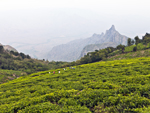 "+
"
"+
" "+
"
"+
" "+
"
"+
" "+
"",
ooticoonoorbengali : "উটি ও কুন্নুরঃ-উটি বা উটাকমাণ্ড নীলগিরি জেলার একটা পাহাড়ি জনপদ। ভ্রমণার্থী ও পর্যটকদের জন্যে এটা অত্যন্ত জনপ্রিয় পর্যটন কেন্দ্র। জনপদটা মূলতঃ টোডা উপজাতি অধ্যুষিত এলাকা হলেও এখানে কোটা, বাডাগা ও কুরুম্বা উপজাতিদের অস্তিত্বও রয়েছে। তাদের জীবিকা প্রধানত পর্যটন ও চাষ-আবাদ। অষ্টাদশ শতাব্দীতে ব্রিটিশ ইষ্ট ইণ্ডিয়া কোম্পানি উটি দখল করে। এখানে অনেক ঔষধের ও এক সময়ে ফটোগ্রাফারদের হৃদয় জয় করা ইন্দু ফিল্মের কারখানা আছে। প্রাকৃতিক সৌন্দর্যের আকর্ষণ ও ঠাণ্ডা পরিবেশের জন্যে উটিতে অনেক পর্যটকের সমাগম হয়, বিশেষতঃ গ্রীষ্মকালে। উটাকমাণ্ড কথাটা কোথা থেকে এসেছে সেটা জানা যায়নি তবে ১৮২১ সালে মাদ্রাজ গেজেটে এই রকম একটা নাম পাওয়া যায়। তামিল সাহিত্য অনুযায়ী দ্বিতীয় শতাব্দীতে চেরা রাজা সেঙ্গুট্টুভান হিমালয়ের দিকে যাত্রা করার সময় এখানে রাজত্ব করেন। চেরা, গঙ্গা, কাদম্ব, রাষ্ট্রকুটা, চোলা, বিজয়নগরের রাজা ইত্যাদি রাজারা নীলগিরি রাজত্ব করেন। টিপু সুলতান নীলগিরি ব্রিটিশদের হাতে ছেড়ে দেন ১৭৯৯ সালে। কোয়াম্বাটোরের কালেক্টর জন সুলিভানের সহায়ক এন কিনডার্সলে নীলগিরি পরিদর্শন করে এক রিপোর্ট দেন। তার বর্ণনায় এই এলাকায় রয়েছে অসাধারণ ঝোরা-ঝর্ণা ও প্রচুর নদীপ্রবাহ যা ঘন সবুজ পরিবেশের মধ্যে লুকিয়ে আছে, আর সুন্দর সুন্দর সবুজ উপত্যকা এলাকার শ্রী বৃদ্ধি করেছে। এই অঞ্চল ইউরোপের যে কোনও জায়গার থেকে কম কিছু নয় ও সুইজারল্যান্ডের সঙ্গে তুলনীয়। এই রিপোর্ট পাবার পর ১৮২৩ সালে রাস্তা তৈরি হয় যা ১৮৩২ সালে কুন্নুর অব্দি বিস্তৃত হয়েছিল। "+
"Read More..."+
"
"+
"",
ooticoonoorbengali : "উটি ও কুন্নুরঃ-উটি বা উটাকমাণ্ড নীলগিরি জেলার একটা পাহাড়ি জনপদ। ভ্রমণার্থী ও পর্যটকদের জন্যে এটা অত্যন্ত জনপ্রিয় পর্যটন কেন্দ্র। জনপদটা মূলতঃ টোডা উপজাতি অধ্যুষিত এলাকা হলেও এখানে কোটা, বাডাগা ও কুরুম্বা উপজাতিদের অস্তিত্বও রয়েছে। তাদের জীবিকা প্রধানত পর্যটন ও চাষ-আবাদ। অষ্টাদশ শতাব্দীতে ব্রিটিশ ইষ্ট ইণ্ডিয়া কোম্পানি উটি দখল করে। এখানে অনেক ঔষধের ও এক সময়ে ফটোগ্রাফারদের হৃদয় জয় করা ইন্দু ফিল্মের কারখানা আছে। প্রাকৃতিক সৌন্দর্যের আকর্ষণ ও ঠাণ্ডা পরিবেশের জন্যে উটিতে অনেক পর্যটকের সমাগম হয়, বিশেষতঃ গ্রীষ্মকালে। উটাকমাণ্ড কথাটা কোথা থেকে এসেছে সেটা জানা যায়নি তবে ১৮২১ সালে মাদ্রাজ গেজেটে এই রকম একটা নাম পাওয়া যায়। তামিল সাহিত্য অনুযায়ী দ্বিতীয় শতাব্দীতে চেরা রাজা সেঙ্গুট্টুভান হিমালয়ের দিকে যাত্রা করার সময় এখানে রাজত্ব করেন। চেরা, গঙ্গা, কাদম্ব, রাষ্ট্রকুটা, চোলা, বিজয়নগরের রাজা ইত্যাদি রাজারা নীলগিরি রাজত্ব করেন। টিপু সুলতান নীলগিরি ব্রিটিশদের হাতে ছেড়ে দেন ১৭৯৯ সালে। কোয়াম্বাটোরের কালেক্টর জন সুলিভানের সহায়ক এন কিনডার্সলে নীলগিরি পরিদর্শন করে এক রিপোর্ট দেন। তার বর্ণনায় এই এলাকায় রয়েছে অসাধারণ ঝোরা-ঝর্ণা ও প্রচুর নদীপ্রবাহ যা ঘন সবুজ পরিবেশের মধ্যে লুকিয়ে আছে, আর সুন্দর সুন্দর সবুজ উপত্যকা এলাকার শ্রী বৃদ্ধি করেছে। এই অঞ্চল ইউরোপের যে কোনও জায়গার থেকে কম কিছু নয় ও সুইজারল্যান্ডের সঙ্গে তুলনীয়। এই রিপোর্ট পাবার পর ১৮২৩ সালে রাস্তা তৈরি হয় যা ১৮৩২ সালে কুন্নুর অব্দি বিস্তৃত হয়েছিল। "+
"Read More..."+
" "+
"
"+
" "+
"
"+
" "+
"
"+
" "+
"
"+
" "+
"
"+
" "+
"
"+
"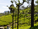 "+
"
"+
" "+
"",
mudumalaibengali : "মুডুমালাইঃ-কেরালা, কর্ণাটক ও তামিলনাডুর এই তিন রাজ্যের সংযোগস্থলে অবস্থিত মুডুমালাই সারা দেশের মধ্যে একটা অন্যতম গুরুত্বপূর্ণ এবং অনন্য সুন্দর অভয়ারণ্য। ৩২১ স্কো. কি.মি. অঞ্চল পরিবৃত এই অভয়ারণ্যে রয়েছে প্রচুর স্পটেড ডিয়ার, হাতি, বাইসন, বাঘ, চিতাবাঘ, ভালুক, কালো চিতা, বনবেড়াল, বেজি, কৃষ্ণসার মৃগ, শিয়াল, বাঁদর ও অন্যান্য জীবজন্তু। আদিম পিঁপড়ে খাওয়া প্যাঙ্গোলিন একমাত্র এখানেই পাওয়া যায়। এখানকার পক্ষী সাম্রাজ্যের বিস্তৃতিও নেহাত কম নয়। পাইকারা লেক উটি থেকে মাত্র ১৯ কি.মি. দূরে অবস্থিত। পাইকারা নদী টোডা উপজাতিদের কাছে অত্যন্ত পবিত্র নদী হিসাবে বিবেচিত। মুকুরতি পর্বতমালা থেকে বেরিয়ে উত্তরদিকে প্রবাহিত হয়ে মালভূমির কিনারায় এসে তার প্রবাহ পশ্চিমদিকে চলমান। এই নদীতে প্রচুর ছোট বড় জলপ্রপাত আছে যার মধ্যে ৫৫ মিটার ও ৬১ মিটার উচ্চ জলপ্রপাতকে পাইকারা ফলস বলে। এই এলাকায় টোডা উপজাতিদের বাস ও অনেক রকমের বন্যপ্রাণী রয়েছে। "+
"Read More..."+
"
"+
"",
mudumalaibengali : "মুডুমালাইঃ-কেরালা, কর্ণাটক ও তামিলনাডুর এই তিন রাজ্যের সংযোগস্থলে অবস্থিত মুডুমালাই সারা দেশের মধ্যে একটা অন্যতম গুরুত্বপূর্ণ এবং অনন্য সুন্দর অভয়ারণ্য। ৩২১ স্কো. কি.মি. অঞ্চল পরিবৃত এই অভয়ারণ্যে রয়েছে প্রচুর স্পটেড ডিয়ার, হাতি, বাইসন, বাঘ, চিতাবাঘ, ভালুক, কালো চিতা, বনবেড়াল, বেজি, কৃষ্ণসার মৃগ, শিয়াল, বাঁদর ও অন্যান্য জীবজন্তু। আদিম পিঁপড়ে খাওয়া প্যাঙ্গোলিন একমাত্র এখানেই পাওয়া যায়। এখানকার পক্ষী সাম্রাজ্যের বিস্তৃতিও নেহাত কম নয়। পাইকারা লেক উটি থেকে মাত্র ১৯ কি.মি. দূরে অবস্থিত। পাইকারা নদী টোডা উপজাতিদের কাছে অত্যন্ত পবিত্র নদী হিসাবে বিবেচিত। মুকুরতি পর্বতমালা থেকে বেরিয়ে উত্তরদিকে প্রবাহিত হয়ে মালভূমির কিনারায় এসে তার প্রবাহ পশ্চিমদিকে চলমান। এই নদীতে প্রচুর ছোট বড় জলপ্রপাত আছে যার মধ্যে ৫৫ মিটার ও ৬১ মিটার উচ্চ জলপ্রপাতকে পাইকারা ফলস বলে। এই এলাকায় টোডা উপজাতিদের বাস ও অনেক রকমের বন্যপ্রাণী রয়েছে। "+
"Read More..."+
" "+
"
"+
" "+
"
"+
" "+
"
"+
" "+
"
"+
" "+
"
"+
" "+
"
"+
" "+
"
"+
" "+
"",
coimbatorbengali : "কোয়াম্বটোরঃ-পশ্চিম তামিলনাডুতে নীলগিরির পাদদেশে অবস্থিত কোয়াম্বাটোর জেলার সদর দপ্তর কোয়াম্বটোর শহর। এটা তামিলনাডুর তৃতীয় বৃহত্তম শহর। কোয়াম্বটোর তার কৃষিজ উৎপাদন ও স্বাস্থ্যকর জলবায়ুর জন্যে পরিচিত। এই শহর অত্যন্ত শিল্পায়িত, বিশেষতঃ বস্ত্রশিল্প, আর তাই জন্যে কোয়াম্বটোরকে দক্ষিণ ভারতের ম্যানচেস্টার বলে। এখানে প্রায় ১০০টার ওপর বস্ত্র কারখানা আছে যা প্রায় গোটা তামিলনাডুর বস্ত্র কারখানার অর্ধেক। এই জেলা তামিলনাডুর অত্যন্ত বর্ধিষ্ণু অঞ্চল। এখানে শাকসবজি, ধান, তুলো, চা, তৈলবীজ, সুপুরি, হলুদ, কফি ও তামাক চাষ হয়। কৃষি ও শিল্প সম্পদের প্রাচুর্য থাকা সত্যেও কোয়াম্বটোর কিন্তু তার প্রাচীন সংস্কৃতি ও সামাজিক রীতিনীতি মেনে চলে। এখানকার মানুষদের পারিবারিক বন্ধন অত্যন্ত মজবুত আর পরিবারের সমস্ত সদস্য তাদের পুরানো ঐতিহ্য ও সনাতনী প্রথা মেনে চলে। শিল্পশহর হলেও এখানকার প্রাকৃতিক দৃশ্যাবলীও যথেষ্ট মনোরম। পাহাড়ি অরণ্যে দেখা পাওয়া যায় অজস্র ঝোরা-ঝর্ণা, জীবজন্তু ও আদিবাসীদের জীবনযাত্রা সাথে ইতিহাস ও ঐতিহ্য সংপৃক্ত অনেক পুরানো মন্দির। "+
"Read More..."+
"
"+
"",
coimbatorbengali : "কোয়াম্বটোরঃ-পশ্চিম তামিলনাডুতে নীলগিরির পাদদেশে অবস্থিত কোয়াম্বাটোর জেলার সদর দপ্তর কোয়াম্বটোর শহর। এটা তামিলনাডুর তৃতীয় বৃহত্তম শহর। কোয়াম্বটোর তার কৃষিজ উৎপাদন ও স্বাস্থ্যকর জলবায়ুর জন্যে পরিচিত। এই শহর অত্যন্ত শিল্পায়িত, বিশেষতঃ বস্ত্রশিল্প, আর তাই জন্যে কোয়াম্বটোরকে দক্ষিণ ভারতের ম্যানচেস্টার বলে। এখানে প্রায় ১০০টার ওপর বস্ত্র কারখানা আছে যা প্রায় গোটা তামিলনাডুর বস্ত্র কারখানার অর্ধেক। এই জেলা তামিলনাডুর অত্যন্ত বর্ধিষ্ণু অঞ্চল। এখানে শাকসবজি, ধান, তুলো, চা, তৈলবীজ, সুপুরি, হলুদ, কফি ও তামাক চাষ হয়। কৃষি ও শিল্প সম্পদের প্রাচুর্য থাকা সত্যেও কোয়াম্বটোর কিন্তু তার প্রাচীন সংস্কৃতি ও সামাজিক রীতিনীতি মেনে চলে। এখানকার মানুষদের পারিবারিক বন্ধন অত্যন্ত মজবুত আর পরিবারের সমস্ত সদস্য তাদের পুরানো ঐতিহ্য ও সনাতনী প্রথা মেনে চলে। শিল্পশহর হলেও এখানকার প্রাকৃতিক দৃশ্যাবলীও যথেষ্ট মনোরম। পাহাড়ি অরণ্যে দেখা পাওয়া যায় অজস্র ঝোরা-ঝর্ণা, জীবজন্তু ও আদিবাসীদের জীবনযাত্রা সাথে ইতিহাস ও ঐতিহ্য সংপৃক্ত অনেক পুরানো মন্দির। "+
"Read More..."+
" "+
"
"+
" "+
"
"+
" "+
"
"+
" "+
"
"+
" "+
"
"+
" "+
"
"+
" "+
"
"+
" "+
"",
kodaikanalbengali : "কোদাইকানালঃ-তামিলনাডুর ডিণ্ডিগুল জেলায় অবস্থিত একটা সুন্দর পাহাড়ি শহর কোদাইকানাল। তামিল ভাষায় এর অর্থ–জঙ্গলের দান। পালানি পাহাড়ের মুকুট হচ্ছে কোদাইকানাল। পুরো এলাকাটা ঘন জঙ্গল দিয়ে ঘেরা ও তাই অনেক সময় এই জনপদকে পাহাড়ি অঞ্চলের রাণী বলা হয় যার অনেক ইতিহাস এই জনপ্রিয় পর্যটন শহরের সঙ্গে যুক্ত। কোদাইকানালের পুরানো বাসিন্দা হ'ল পালি আদিবাসী গোষ্ঠি। তামিল সঙ্গম সাহিত্যে কোদাইকানালের নাম পাওয়া যায়। ১৮৪৫ সালে আধুনিক কোদাইকানাল প্রতিষ্ঠা করেন এক আমেরিকান খৃষ্টান মিশনারি ও ব্রিটিশ আমলারা। এদের কোদাইকানালে আসার প্রধান কারণ ছিল সমতলের তীব্র গরমে তাদের শরীরে তৈরি হওয়া ক্রান্তীয় রোগের হাত থেকে রেহাই পাওয়া। বিংশ শতাব্দীতে কিছু অভিজাত ভারতীয় এই সুন্দর জায়গাটার মর্ম উপলব্ধি করেন ও এখানে বসবাস শুরু করেন। পর্যটনের খানিকটা বিঘ্ন ঘটে যখন এখানে একটা ইউনিলিভারের ভারতীয় সহায়ক কোম্পানি হিন্দুস্থান ইউনিলিভার একটা পারদের কারখানা তৈরি করে। এ নিয়ে অনেক প্রতিবাদ প্রতিরোধ হলেও তেমন কিছু করা যায়নি। ২০১৫ সালে Kodaikanal Won’t নামে একটা RAP মিউজিক সারা দুনিয়ায় প্রতিবাদের ভাষা তৈরি করে ও চারদিনে প্রায় এক মিলিয়ন লোক তা শোনে। কিন্তু তা সত্যেও এখনও অব্দি পারদ পরিষ্কার করার কোনও সুনির্দিষ্ট কর্মসূচি নেওয়া হয়নি। "+
"Read More..."+
"
"+
"",
kodaikanalbengali : "কোদাইকানালঃ-তামিলনাডুর ডিণ্ডিগুল জেলায় অবস্থিত একটা সুন্দর পাহাড়ি শহর কোদাইকানাল। তামিল ভাষায় এর অর্থ–জঙ্গলের দান। পালানি পাহাড়ের মুকুট হচ্ছে কোদাইকানাল। পুরো এলাকাটা ঘন জঙ্গল দিয়ে ঘেরা ও তাই অনেক সময় এই জনপদকে পাহাড়ি অঞ্চলের রাণী বলা হয় যার অনেক ইতিহাস এই জনপ্রিয় পর্যটন শহরের সঙ্গে যুক্ত। কোদাইকানালের পুরানো বাসিন্দা হ'ল পালি আদিবাসী গোষ্ঠি। তামিল সঙ্গম সাহিত্যে কোদাইকানালের নাম পাওয়া যায়। ১৮৪৫ সালে আধুনিক কোদাইকানাল প্রতিষ্ঠা করেন এক আমেরিকান খৃষ্টান মিশনারি ও ব্রিটিশ আমলারা। এদের কোদাইকানালে আসার প্রধান কারণ ছিল সমতলের তীব্র গরমে তাদের শরীরে তৈরি হওয়া ক্রান্তীয় রোগের হাত থেকে রেহাই পাওয়া। বিংশ শতাব্দীতে কিছু অভিজাত ভারতীয় এই সুন্দর জায়গাটার মর্ম উপলব্ধি করেন ও এখানে বসবাস শুরু করেন। পর্যটনের খানিকটা বিঘ্ন ঘটে যখন এখানে একটা ইউনিলিভারের ভারতীয় সহায়ক কোম্পানি হিন্দুস্থান ইউনিলিভার একটা পারদের কারখানা তৈরি করে। এ নিয়ে অনেক প্রতিবাদ প্রতিরোধ হলেও তেমন কিছু করা যায়নি। ২০১৫ সালে Kodaikanal Won’t নামে একটা RAP মিউজিক সারা দুনিয়ায় প্রতিবাদের ভাষা তৈরি করে ও চারদিনে প্রায় এক মিলিয়ন লোক তা শোনে। কিন্তু তা সত্যেও এখনও অব্দি পারদ পরিষ্কার করার কোনও সুনির্দিষ্ট কর্মসূচি নেওয়া হয়নি। "+
"Read More..."+
" "+
"
"+
" "+
"
"+
" "+
"
"+
" "+
"
"+
" "+
"
"+
" "+
"
"+
" "+
"
"+
" "+
"",
kanyakumaribengali : "কন্যাকুমারীঃ-কন্যাকুমারী, জলবেষ্টিত ভারতের শেষ জনপদ। এই জনপদের মহিমা তার সূর্যোদয় ও সূর্যাস্তের জন্যে। আর তা অদ্বিতীয় কারণ এখানেই রয়েছে ভারত মহাসাগর, আরব সাগর আর বঙ্গোপসাগরের সঙ্গমস্থল। এটা ভারতের সেই বিন্দু যেখানে পূর্ণচন্দ্রিমায় একই সাথে সূর্যাস্ত ও চন্দ্রোদয় দেখা যায়। কন্যাকুমারী শুধু তামিলনাডুর শেষ জেলা নয় ভারতেরও শেষ স্থানাঙ্ক যার সদর দপ্তর রয়েছে ২২ কি.মি. দূরের নাগেরকোয়েলে। কন্যাকুমারীকে ঘিরে রেখেছে রাজকীয় পাহাড়ের শ্রেণী আর সমতলে রয়েছে রঙবেরঙের সমুদ্রসৈকত যার আঁচলে রয়েছে নকশি করা শাড়ির মতো নারকোল গাছ ও ধানক্ষেতের সবুজ প্রাঙ্গণ। পাহাড়ের শ্রেণী ও সমতলের মধ্যে রয়েছে, এখানে সেখানে ছড়িয়ে ছিটিয়ে থাকা ছোট ছোট অনুচ্চ পাহাড়ের লাল ক্লিফ, তরঙ্গায়িত উপত্যকা ও বিচিত্র সমুদ্রসৈকতের সঙ্গে ঠাস বুননে জড়িয়ে আছে মন্দির, গির্জা ও অন্যান্য সৌধ। এখানকার মানুষজন সহজ সরল এবং ধার্মিক হলেও তামিলনাডুতে সবথেকে শিক্ষিত জেলার খেতাব কন্যাকুমারীই অর্জন করেছে। "+
"Read More..."+
"
"+
"",
kanyakumaribengali : "কন্যাকুমারীঃ-কন্যাকুমারী, জলবেষ্টিত ভারতের শেষ জনপদ। এই জনপদের মহিমা তার সূর্যোদয় ও সূর্যাস্তের জন্যে। আর তা অদ্বিতীয় কারণ এখানেই রয়েছে ভারত মহাসাগর, আরব সাগর আর বঙ্গোপসাগরের সঙ্গমস্থল। এটা ভারতের সেই বিন্দু যেখানে পূর্ণচন্দ্রিমায় একই সাথে সূর্যাস্ত ও চন্দ্রোদয় দেখা যায়। কন্যাকুমারী শুধু তামিলনাডুর শেষ জেলা নয় ভারতেরও শেষ স্থানাঙ্ক যার সদর দপ্তর রয়েছে ২২ কি.মি. দূরের নাগেরকোয়েলে। কন্যাকুমারীকে ঘিরে রেখেছে রাজকীয় পাহাড়ের শ্রেণী আর সমতলে রয়েছে রঙবেরঙের সমুদ্রসৈকত যার আঁচলে রয়েছে নকশি করা শাড়ির মতো নারকোল গাছ ও ধানক্ষেতের সবুজ প্রাঙ্গণ। পাহাড়ের শ্রেণী ও সমতলের মধ্যে রয়েছে, এখানে সেখানে ছড়িয়ে ছিটিয়ে থাকা ছোট ছোট অনুচ্চ পাহাড়ের লাল ক্লিফ, তরঙ্গায়িত উপত্যকা ও বিচিত্র সমুদ্রসৈকতের সঙ্গে ঠাস বুননে জড়িয়ে আছে মন্দির, গির্জা ও অন্যান্য সৌধ। এখানকার মানুষজন সহজ সরল এবং ধার্মিক হলেও তামিলনাডুতে সবথেকে শিক্ষিত জেলার খেতাব কন্যাকুমারীই অর্জন করেছে। "+
"Read More..."+
" "+
"
"+
" "+
"
"+
" "+
"
"+
" "+
"
"+
" "+
"
"+
" "+
"
"+
" "+
"
"+
" "+
"",
maduraibengali : "মাদুরাইঃ-ভাগাই নদীর তীরে অবস্থিত মাদুরাই জেলার সদর দপ্তর মাদুরাই শহর। এটা তামিলনাডুর দ্বিতীয় বৃহত্তম শহর। এই শহর খৃষ্টপূর্ব তৃতীয় শতাব্দী থেকে বর্তমান ও তামিলনাডুর অন্যতম সাংস্কৃতিক ও বাণিজ্যিক কেন্দ্রস্থল। সঙ্গম সাহিত্য থেকে জানা যায় যে ৫৯০ সালে যখন পাণ্ডা রাজারা মাদুরাইয়ে তাঁদের রাজধানী স্থাপন করেছিলেন তখনও মাদুরাই দাক্ষিণাত্যের অন্যতম শহর হিসাবে স্বীকৃত ছিল। আধুনিক মাদুরাই দ্রুত বেড়ে উঠছে একটা শিল্পনগরী হিসাবে যদিও এখানে রয়েছে অনেক সবুজ ধানক্ষেতের বিস্তৃতি, ধুলাময় ঘিঞ্জি নগর জনপদ ও জনাকীর্ণ ব্যস্ত বাজার। মেগাস্থিনিস হয়ত এই শহরে এসেছিলেন খৃষ্টপূর্ব তৃতীয় শতকে যখন এই শহরকে মেথরা বলে উল্লেখ করেছেন যা উত্তর ভারতের মথুরার সমার্থক এবং যা তৎকালীন ময়ূরা রাজত্বের একটা বিশাল শহর ছিল। গ্রীক গণিতবিদ পি টেলমি তাঁর লেখায় মাদুরাইয়ের নাম করেন। প্রথমে কালাভ্রা রাজত্ব, পরে পাণ্ডা ও শেষকালে চোলা রাজত্বের রাজারা মাদুরাই রাজত্ব করেন এবং তা চলে প্রায় ত্রয়োদশ শতাব্দী অব্দি। পরবর্তীকালে মাদুরাই দিল্লীর সুলতানদের কব্জায় আসে। কিন্তু বিজয়নগরের স্বাধীন রাজারা ১৩৭৮ সালে মাদুরাই দখল করে। ১৫৫৯ সালে নায়েকরা মাদুরাই দখল করে ও ১৭৩৬ সাল অব্দি রাজত্ব করেন। তাঁরাই তৈরি করেন স্থাপত্যসমৃদ্ধ বিখ্যাত মীনাক্ষী মন্দির। অষ্টাদশ শতাব্দী অব্দি চন্দ সাহিব, কর্ণাটকের নবাব ও মহম্মদ ইউসুফ খান মাদুরাইয়ের ক্ষমতা দখল করেন। ১৮০১ সালে মাদুরাই পুরোপুরি ব্রিটিশদের দখলে আসে ও মাদ্রাজ প্রেসিডেন্সিতে অন্তর্ভুক্ত হয়। প্রথমদিকে তাঁরা মীনাক্ষী মন্দিরের জন্য অর্থ সাহায্য ও বিভিন্ন হিন্দু অনুষ্ঠানে অংশগ্রহণ করতেন। ঊনবিংশ ও বিংশ শতাব্দীতে মাদুরাই জেলা রাজনৈতিক ও শিল্পায়নের কেন্দ্রস্থল হিসাবে আত্মপ্রকাশ করে। ব্রিটিশরা ১৮৩৭ সালে মীনাক্ষী মন্দিরকে ঘিরে থাকা ফোর্টের দেওয়াল ভেঙ্গে দেয় ও ফোর্টের চতুর্দিকে একটা পরিখা তৈরি করে। ভাঙ্গা আবর্জনা দিয়ে নতুন রাস্তা তৈরি করে। মাদুরাইয়ে প্রথম মিউনিসিপ্যলিটি তৈরি হয় ১৮৬৬ সালে। "+
"Read More..."+
"
"+
"",
maduraibengali : "মাদুরাইঃ-ভাগাই নদীর তীরে অবস্থিত মাদুরাই জেলার সদর দপ্তর মাদুরাই শহর। এটা তামিলনাডুর দ্বিতীয় বৃহত্তম শহর। এই শহর খৃষ্টপূর্ব তৃতীয় শতাব্দী থেকে বর্তমান ও তামিলনাডুর অন্যতম সাংস্কৃতিক ও বাণিজ্যিক কেন্দ্রস্থল। সঙ্গম সাহিত্য থেকে জানা যায় যে ৫৯০ সালে যখন পাণ্ডা রাজারা মাদুরাইয়ে তাঁদের রাজধানী স্থাপন করেছিলেন তখনও মাদুরাই দাক্ষিণাত্যের অন্যতম শহর হিসাবে স্বীকৃত ছিল। আধুনিক মাদুরাই দ্রুত বেড়ে উঠছে একটা শিল্পনগরী হিসাবে যদিও এখানে রয়েছে অনেক সবুজ ধানক্ষেতের বিস্তৃতি, ধুলাময় ঘিঞ্জি নগর জনপদ ও জনাকীর্ণ ব্যস্ত বাজার। মেগাস্থিনিস হয়ত এই শহরে এসেছিলেন খৃষ্টপূর্ব তৃতীয় শতকে যখন এই শহরকে মেথরা বলে উল্লেখ করেছেন যা উত্তর ভারতের মথুরার সমার্থক এবং যা তৎকালীন ময়ূরা রাজত্বের একটা বিশাল শহর ছিল। গ্রীক গণিতবিদ পি টেলমি তাঁর লেখায় মাদুরাইয়ের নাম করেন। প্রথমে কালাভ্রা রাজত্ব, পরে পাণ্ডা ও শেষকালে চোলা রাজত্বের রাজারা মাদুরাই রাজত্ব করেন এবং তা চলে প্রায় ত্রয়োদশ শতাব্দী অব্দি। পরবর্তীকালে মাদুরাই দিল্লীর সুলতানদের কব্জায় আসে। কিন্তু বিজয়নগরের স্বাধীন রাজারা ১৩৭৮ সালে মাদুরাই দখল করে। ১৫৫৯ সালে নায়েকরা মাদুরাই দখল করে ও ১৭৩৬ সাল অব্দি রাজত্ব করেন। তাঁরাই তৈরি করেন স্থাপত্যসমৃদ্ধ বিখ্যাত মীনাক্ষী মন্দির। অষ্টাদশ শতাব্দী অব্দি চন্দ সাহিব, কর্ণাটকের নবাব ও মহম্মদ ইউসুফ খান মাদুরাইয়ের ক্ষমতা দখল করেন। ১৮০১ সালে মাদুরাই পুরোপুরি ব্রিটিশদের দখলে আসে ও মাদ্রাজ প্রেসিডেন্সিতে অন্তর্ভুক্ত হয়। প্রথমদিকে তাঁরা মীনাক্ষী মন্দিরের জন্য অর্থ সাহায্য ও বিভিন্ন হিন্দু অনুষ্ঠানে অংশগ্রহণ করতেন। ঊনবিংশ ও বিংশ শতাব্দীতে মাদুরাই জেলা রাজনৈতিক ও শিল্পায়নের কেন্দ্রস্থল হিসাবে আত্মপ্রকাশ করে। ব্রিটিশরা ১৮৩৭ সালে মীনাক্ষী মন্দিরকে ঘিরে থাকা ফোর্টের দেওয়াল ভেঙ্গে দেয় ও ফোর্টের চতুর্দিকে একটা পরিখা তৈরি করে। ভাঙ্গা আবর্জনা দিয়ে নতুন রাস্তা তৈরি করে। মাদুরাইয়ে প্রথম মিউনিসিপ্যলিটি তৈরি হয় ১৮৬৬ সালে। "+
"Read More..."+
" "+
"
"+
" "+
"
"+
" "+
"
"+
" "+
"
"+
" "+
"
"+
" "+
"
"+
" "+
"
"+
" "+
"",
rameshwarambengali : "রামেশ্বরমঃ-রামেশ্বরম তামিলনাডুর রামনাথপুরম জেলায় অবস্থিত একটা ছোট্ট জনপদ। পামবন চ্যানেল দ্বারা মূল ভূখণ্ড থেকে বিচ্ছিন্ন হয়ে পামবন আইল্যান্ডে অবস্থিত রামেশ্বরম, শ্রীলঙ্কার মান্নার দ্বীপ থেকে মাত্র ৫০ কি.মি. দূরে অবস্থিত যা ভারতীয় পেনিনসুলার খুব কাছেই পড়ে। রামেশ্বরম হিন্দুদের কাছে এক অন্যতম পবিত্র তীর্থস্থান বলে বিবেচিত। লোককথা বলে যে সীতাকে রাবণের হাত থেকে উদ্ধার করার জন্যে ভগবান রাম সমুদ্রের ওপর দিয়ে ভারত থেকে শ্রীলঙ্কা অব্দি এক ব্রিজ তৈরি করেন। রামেশ্বরম শ্রীলঙ্কার এতই কাছে যে বিভিন্ন ভারতীয় মৎস্যজীবীদের, শ্রীলঙ্কার মিলিটারিদের দ্বারা বন্দী হওয়া প্রায় রোজের খবর। রামেশ্বরমের মূল জীবিকা মৎসশিকার ও পর্যটন। রামেশ্বরমে রামানাথস্বামী মন্দিরে রামের (বিষ্ণুর এক রূপ রাম) পুজো করা হয় ও মন্দিরটা সেই নামেই উৎসর্গ করা আছে। লোককথা অনুযায়ী ব্রাহ্মণ রাবণের সঙ্গে যুদ্ধ করার সময় যদি ব্রহ্মহত্যার কোনও পাপ হয়ে থাকে তা মুছে ব্রহ্মত্ব লাভ করার জন্যে, বিষ্ণুর সপ্তম অবতার রাম, বহু সন্ন্যাসীর পরামর্শে রামেশ্বরমে শিবের পুজো করতে শুরু করেন। এই শিবলিঙ্গ হিমালয় থেকে আনার জন্যে রাম তাঁর বানর সেনাপতি হনুমানকে আদেশ দেন। হনুমানের দেরির কারণে সীতা বালি দিয়ে এক শিবলিঙ্গ তৈরি করেন ও তা পূজা করা হয়। রামেশ্বরমের ইতিহাস রচিত হয় রামনাথস্বামী মন্দির ও একটা দ্বীপ নিয়ে যা ভারত ও শ্রীলঙ্কা যাবার একটা ট্রানজিট পয়েন্ট ছিল। চোলা রাজবংশের রাজা, রাজেন্দর চোলার এই জনপদের ওপর সাময়িক নিয়ন্ত্রণ ছিল। জাফনার রাজাদের রামেশ্বরমের সাথে ঘনিষ্ঠ যোগাযোগ ছিল ও নাম দিয়েছিলেন সেতুকভলন। যেহেতু জাফনার রাজার হিন্দু ছিলেন তাই রামশ্বরমের জন্য অনেক ব্যয় করতেন। রামেশ্বরমের সেতু তাঁদের কয়েনের খোদাই হিসাবে দৃশ্যমান ছিল। দিল্লীর সুলতানের সেনাপতি আলাউদ্দীন খিলিজী তাঁর সৈন্যদল নিয়ে রামেশ্বরমে পৌঁছান ধর্মীয় প্রচারের উদ্দেশ্যে। প্রচুর বাধা স্বত্বেও খিলিজী একটা মসজিদ তৈরি করেন ও ইসলামের জয় হিসাবে তার নাম দেয় আলিয়া-আল-দিন-খালদিজী। পঞ্চদশ শতাব্দীর প্রথম দিকে পুরো এলাকা পাণ্ডা রাজাদের আয়ত্তে আসে। ১৫২০ সালে বিজয়নগরের রাজাদের হাতে আসে ও তাঁরা রামেশ্বরমের মন্দিরের উন্নতির জন্যে অনেক ব্যয় করেন। পরবর্তীকালে কর্ণাটকের নবাব, মহম্মদ ইউসুফ খান ও অন্যান্য মুসলিম রাজারা বহুবার রামেশ্বরম আক্রমণ করেন ও দখল করেন। ১৭৯৫ সালে ব্রিটিশরা রামেশ্বরমের দখল নেয় ও ১৯৪৭ সাল অব্দি তা কায়েম রাখে। "+
"Read More..."+
"
"+
"",
rameshwarambengali : "রামেশ্বরমঃ-রামেশ্বরম তামিলনাডুর রামনাথপুরম জেলায় অবস্থিত একটা ছোট্ট জনপদ। পামবন চ্যানেল দ্বারা মূল ভূখণ্ড থেকে বিচ্ছিন্ন হয়ে পামবন আইল্যান্ডে অবস্থিত রামেশ্বরম, শ্রীলঙ্কার মান্নার দ্বীপ থেকে মাত্র ৫০ কি.মি. দূরে অবস্থিত যা ভারতীয় পেনিনসুলার খুব কাছেই পড়ে। রামেশ্বরম হিন্দুদের কাছে এক অন্যতম পবিত্র তীর্থস্থান বলে বিবেচিত। লোককথা বলে যে সীতাকে রাবণের হাত থেকে উদ্ধার করার জন্যে ভগবান রাম সমুদ্রের ওপর দিয়ে ভারত থেকে শ্রীলঙ্কা অব্দি এক ব্রিজ তৈরি করেন। রামেশ্বরম শ্রীলঙ্কার এতই কাছে যে বিভিন্ন ভারতীয় মৎস্যজীবীদের, শ্রীলঙ্কার মিলিটারিদের দ্বারা বন্দী হওয়া প্রায় রোজের খবর। রামেশ্বরমের মূল জীবিকা মৎসশিকার ও পর্যটন। রামেশ্বরমে রামানাথস্বামী মন্দিরে রামের (বিষ্ণুর এক রূপ রাম) পুজো করা হয় ও মন্দিরটা সেই নামেই উৎসর্গ করা আছে। লোককথা অনুযায়ী ব্রাহ্মণ রাবণের সঙ্গে যুদ্ধ করার সময় যদি ব্রহ্মহত্যার কোনও পাপ হয়ে থাকে তা মুছে ব্রহ্মত্ব লাভ করার জন্যে, বিষ্ণুর সপ্তম অবতার রাম, বহু সন্ন্যাসীর পরামর্শে রামেশ্বরমে শিবের পুজো করতে শুরু করেন। এই শিবলিঙ্গ হিমালয় থেকে আনার জন্যে রাম তাঁর বানর সেনাপতি হনুমানকে আদেশ দেন। হনুমানের দেরির কারণে সীতা বালি দিয়ে এক শিবলিঙ্গ তৈরি করেন ও তা পূজা করা হয়। রামেশ্বরমের ইতিহাস রচিত হয় রামনাথস্বামী মন্দির ও একটা দ্বীপ নিয়ে যা ভারত ও শ্রীলঙ্কা যাবার একটা ট্রানজিট পয়েন্ট ছিল। চোলা রাজবংশের রাজা, রাজেন্দর চোলার এই জনপদের ওপর সাময়িক নিয়ন্ত্রণ ছিল। জাফনার রাজাদের রামেশ্বরমের সাথে ঘনিষ্ঠ যোগাযোগ ছিল ও নাম দিয়েছিলেন সেতুকভলন। যেহেতু জাফনার রাজার হিন্দু ছিলেন তাই রামশ্বরমের জন্য অনেক ব্যয় করতেন। রামেশ্বরমের সেতু তাঁদের কয়েনের খোদাই হিসাবে দৃশ্যমান ছিল। দিল্লীর সুলতানের সেনাপতি আলাউদ্দীন খিলিজী তাঁর সৈন্যদল নিয়ে রামেশ্বরমে পৌঁছান ধর্মীয় প্রচারের উদ্দেশ্যে। প্রচুর বাধা স্বত্বেও খিলিজী একটা মসজিদ তৈরি করেন ও ইসলামের জয় হিসাবে তার নাম দেয় আলিয়া-আল-দিন-খালদিজী। পঞ্চদশ শতাব্দীর প্রথম দিকে পুরো এলাকা পাণ্ডা রাজাদের আয়ত্তে আসে। ১৫২০ সালে বিজয়নগরের রাজাদের হাতে আসে ও তাঁরা রামেশ্বরমের মন্দিরের উন্নতির জন্যে অনেক ব্যয় করেন। পরবর্তীকালে কর্ণাটকের নবাব, মহম্মদ ইউসুফ খান ও অন্যান্য মুসলিম রাজারা বহুবার রামেশ্বরম আক্রমণ করেন ও দখল করেন। ১৭৯৫ সালে ব্রিটিশরা রামেশ্বরমের দখল নেয় ও ১৯৪৭ সাল অব্দি তা কায়েম রাখে। "+
"Read More..."+
" "+
"
"+
" "+
"
"+
" "+
"
"+
" "+
"
"+
" "+
"
"+
" "+
"
"+
" "+
"
"+
" "+
"",
trichibengali : "তিরুচিরাপল্লীঃ-কাবেরি নদীর তীরে অবস্থিত তিরুচিরাপল্লী বা ত্রিচি তামিলনাডুর চতুর্থ বৃহত্তম শহর। এই শহর বিখ্যাত হয়ে আছে তার উন্নত সংস্কৃতি, স্থাপত্য ও ঐতিহ্যের জন্যে ও এটা অবশ্যই তামিলনাডুর অন্যতম দর্শনীয় স্থান। কাবেরি নদীর ত্রিভুজের আগায় অবস্থিত সমভূমির দুদিকে রয়েছে শেভারয় ও পালানি পাহাড়। প্রত্নতাত্ত্বিক প্রমাণ, পুরানো ভারতীয় সাহিত্য ও টলেমির লেখা অনুযায়ী এই শহরের ইতিহাস তৈরি হয়েছে খৃষ্টপূর্ব ৩০০ সালে। এই শহর দেখেছে প্রথম চোলা, পল্লব, মধ্যযুগীয় চোলা, পাণ্ডব, মোঘল, বিদ্যানগরের রাজা, নায়েক, কর্ণাটকের নবাব ও শেষ অব্দি ব্রিটিশদের রাজত্ব। তিরুচিরাপল্লী তার শ্রেষ্ঠত্বের শিখরে উঠেছিল মাদুরাইয়ের নায়েকদের আমলে। শহরের রক ফোর্ট তৈরি ও শহর বিস্তার লাভ করেছিল সেই আমলেই। ত্রিচি দক্ষিণের একটা গুরুত্বপূর্ণ ব্যবসায়িক কেন্দ্র হয়ে উঠেছিল নায়েকদের আমলেই। ১৮০১ সালে ব্রিটিশ ইষ্ট ইণ্ডিয়া কোম্পানি তিরুচিরাপল্লী জেলা তৈরি করে তাদের রাজধানী হিসাবে ঘোষণা করে। জন ওয়ালেস তিরুচিরাপল্লী জেলার প্রথম কালেক্টরেট হয়েছিল। "+
"Read More..."+
"
"+
"",
trichibengali : "তিরুচিরাপল্লীঃ-কাবেরি নদীর তীরে অবস্থিত তিরুচিরাপল্লী বা ত্রিচি তামিলনাডুর চতুর্থ বৃহত্তম শহর। এই শহর বিখ্যাত হয়ে আছে তার উন্নত সংস্কৃতি, স্থাপত্য ও ঐতিহ্যের জন্যে ও এটা অবশ্যই তামিলনাডুর অন্যতম দর্শনীয় স্থান। কাবেরি নদীর ত্রিভুজের আগায় অবস্থিত সমভূমির দুদিকে রয়েছে শেভারয় ও পালানি পাহাড়। প্রত্নতাত্ত্বিক প্রমাণ, পুরানো ভারতীয় সাহিত্য ও টলেমির লেখা অনুযায়ী এই শহরের ইতিহাস তৈরি হয়েছে খৃষ্টপূর্ব ৩০০ সালে। এই শহর দেখেছে প্রথম চোলা, পল্লব, মধ্যযুগীয় চোলা, পাণ্ডব, মোঘল, বিদ্যানগরের রাজা, নায়েক, কর্ণাটকের নবাব ও শেষ অব্দি ব্রিটিশদের রাজত্ব। তিরুচিরাপল্লী তার শ্রেষ্ঠত্বের শিখরে উঠেছিল মাদুরাইয়ের নায়েকদের আমলে। শহরের রক ফোর্ট তৈরি ও শহর বিস্তার লাভ করেছিল সেই আমলেই। ত্রিচি দক্ষিণের একটা গুরুত্বপূর্ণ ব্যবসায়িক কেন্দ্র হয়ে উঠেছিল নায়েকদের আমলেই। ১৮০১ সালে ব্রিটিশ ইষ্ট ইণ্ডিয়া কোম্পানি তিরুচিরাপল্লী জেলা তৈরি করে তাদের রাজধানী হিসাবে ঘোষণা করে। জন ওয়ালেস তিরুচিরাপল্লী জেলার প্রথম কালেক্টরেট হয়েছিল। "+
"Read More..."+
" "+
"
"+
" "+
"
"+
" "+
"
"+
" "+
"
"+
" "+
"
"+
" "+
"
"+
" "+
"
"+
" "+
"",
narthmalaibengali : "নার্থামালাইঃ-পডুকোট্টাই জেলার এক পঞ্চায়েত গ্রাম নার্থামালাইয়ের বিজয়ালিয়া চোলেশ্বরম মন্দির, শিব ভগবানের উদ্দেশ্যে উৎসর্গ করা আছে আর তা তৈরি হয়েছে পাথর খোদাই করে নাগারা গঠনশৈলীতে। মন্দিরটা নবম শতাব্দীতে পল্লব রাজবংশের মুট্টারাইয়ার রাজারা তৈরি করেন বলে মনে করা হয় ও পরবর্তীকালে তা সম্প্রসারণ করেন চোলা রাজারা। পাথরের খোদাই, চোলা রাজাদের চারুকলার এক অন্যতম নিদর্শন, ও সেই ঐতিহ্য শুরু হয়েছে পল্লব রাজাদের আমল থেকে। নার্থামালাইয়ের অন্য আকর্ষণ হচ্ছে অষ্টম শতাব্দীর একটা জৈন মন্দির আলুরুট্টিমালাই জৈন গুহা। এখানে আরও দুটো পাথরের খোদাই করা গুহা আছে যাতে প্রমাণ মাপের ১২ টা বিষ্ণুর মূর্তি আছে। এই মন্দির দক্ষিণ ভারতে সবথেকে পুরানো মন্দির বলে পরিচিত। "+
"Read More..."+
"
"+
"",
narthmalaibengali : "নার্থামালাইঃ-পডুকোট্টাই জেলার এক পঞ্চায়েত গ্রাম নার্থামালাইয়ের বিজয়ালিয়া চোলেশ্বরম মন্দির, শিব ভগবানের উদ্দেশ্যে উৎসর্গ করা আছে আর তা তৈরি হয়েছে পাথর খোদাই করে নাগারা গঠনশৈলীতে। মন্দিরটা নবম শতাব্দীতে পল্লব রাজবংশের মুট্টারাইয়ার রাজারা তৈরি করেন বলে মনে করা হয় ও পরবর্তীকালে তা সম্প্রসারণ করেন চোলা রাজারা। পাথরের খোদাই, চোলা রাজাদের চারুকলার এক অন্যতম নিদর্শন, ও সেই ঐতিহ্য শুরু হয়েছে পল্লব রাজাদের আমল থেকে। নার্থামালাইয়ের অন্য আকর্ষণ হচ্ছে অষ্টম শতাব্দীর একটা জৈন মন্দির আলুরুট্টিমালাই জৈন গুহা। এখানে আরও দুটো পাথরের খোদাই করা গুহা আছে যাতে প্রমাণ মাপের ১২ টা বিষ্ণুর মূর্তি আছে। এই মন্দির দক্ষিণ ভারতে সবথেকে পুরানো মন্দির বলে পরিচিত। "+
"Read More..."+
" "+
"
"+
" "+
"
"+
" "+
"
"+
" "+
"
"+
" "+
"
"+
" "+
"
"+
" "+
"
"+
" "+
"",
thirumayambengali : "থিরুমায়ামঃ-পুডুকোট্টাই জেলার থিরুমায়াম জনপদের অন্যতম বিখ্যাত দর্শনীয় স্থান হচ্ছে থিরুমায়াম ফোর্ট। ১৬৮৭ সালে এটা তৈরি করেন রামনাদের রাজা বিজয় রঘুনাথ সেথুপথি। পরবর্তীকালে এই ফোর্ট তাঁর শ্যালক রঘুনাথ রায়া টণ্ডাইম্যানকে দিয়ে দেন। ফোর্টটা প্রাথমিক ভাবে তৈরি হয়েছিল একটা গোলাকার ফোর্ট হিসাবে যার সাতটা এককেন্দ্রিক গোলাকার দেওয়াল ছিল। সাতটার মধ্যে চারটে এখনও বেঁচে আছে। ফোর্টের গঠনশৈলী নিম্নমানের কারণ ছোট ছোট পাথরের খণ্ড ও ইট দিয়ে তৈরি করা হয়েছে যা ফোর্টের নিরাপত্তার জন্যে মোটেই ভালো নয়। উত্তর, দক্ষিণ ও পূর্বদিকে ফোর্টের তিনটে প্রবেশপথ রয়েছে। মন্দিরগুলোর মধ্যে হনুমান, শক্তি, গণপতি, কারুপ্পার রয়েছে দক্ষিণদিকে ও উত্তরদিকে রয়েছে ভৈরব মন্দির। একেবারে মাথায় রয়েছে ব্রিটিশ জমানার একটা কামান। এই প্ল্যাটফর্মের দক্ষিণে একটা প্রাকৃতিক জলাশয় ও দুটো পাথর খোদাই করা মন্দির রয়েছে যার মধ্যে একটা শিবের ও একটা বৈষ্ণবদের। মন্দির দুটো ঐতিহাসিক ও ধর্মীয় দিক থেকে যথেষ্ট গুরুত্বপূর্ণ। ১৭৯৯ সালে ব্রিটিশদের সঙ্গে প্রথম পলিগার যুদ্ধের সময় বিদ্রোহী কোট্টাবোমনের রাজা পঞ্চলানকুরুচ্চির ভাই ওমার্থুরাই এই ফোর্টে বন্দী হ’ন ও ব্রিটিশরা তাঁকে ফাঁসি দেয়। পরে ১৮০০ সালে আবার দ্বিতীয় পলিগার যুদ্ধ হয় ও ব্রিটিশদের প্রচুর ক্ষয়ক্ষতি হয়। ২০১২ সালে ভারতের প্রত্নতাত্ত্বিক বিভাগ ফোর্টের মধ্যে ব্যাপক সংস্কার কার্য চালায়। "+
"Read More..."+
"
"+
"",
thirumayambengali : "থিরুমায়ামঃ-পুডুকোট্টাই জেলার থিরুমায়াম জনপদের অন্যতম বিখ্যাত দর্শনীয় স্থান হচ্ছে থিরুমায়াম ফোর্ট। ১৬৮৭ সালে এটা তৈরি করেন রামনাদের রাজা বিজয় রঘুনাথ সেথুপথি। পরবর্তীকালে এই ফোর্ট তাঁর শ্যালক রঘুনাথ রায়া টণ্ডাইম্যানকে দিয়ে দেন। ফোর্টটা প্রাথমিক ভাবে তৈরি হয়েছিল একটা গোলাকার ফোর্ট হিসাবে যার সাতটা এককেন্দ্রিক গোলাকার দেওয়াল ছিল। সাতটার মধ্যে চারটে এখনও বেঁচে আছে। ফোর্টের গঠনশৈলী নিম্নমানের কারণ ছোট ছোট পাথরের খণ্ড ও ইট দিয়ে তৈরি করা হয়েছে যা ফোর্টের নিরাপত্তার জন্যে মোটেই ভালো নয়। উত্তর, দক্ষিণ ও পূর্বদিকে ফোর্টের তিনটে প্রবেশপথ রয়েছে। মন্দিরগুলোর মধ্যে হনুমান, শক্তি, গণপতি, কারুপ্পার রয়েছে দক্ষিণদিকে ও উত্তরদিকে রয়েছে ভৈরব মন্দির। একেবারে মাথায় রয়েছে ব্রিটিশ জমানার একটা কামান। এই প্ল্যাটফর্মের দক্ষিণে একটা প্রাকৃতিক জলাশয় ও দুটো পাথর খোদাই করা মন্দির রয়েছে যার মধ্যে একটা শিবের ও একটা বৈষ্ণবদের। মন্দির দুটো ঐতিহাসিক ও ধর্মীয় দিক থেকে যথেষ্ট গুরুত্বপূর্ণ। ১৭৯৯ সালে ব্রিটিশদের সঙ্গে প্রথম পলিগার যুদ্ধের সময় বিদ্রোহী কোট্টাবোমনের রাজা পঞ্চলানকুরুচ্চির ভাই ওমার্থুরাই এই ফোর্টে বন্দী হ’ন ও ব্রিটিশরা তাঁকে ফাঁসি দেয়। পরে ১৮০০ সালে আবার দ্বিতীয় পলিগার যুদ্ধ হয় ও ব্রিটিশদের প্রচুর ক্ষয়ক্ষতি হয়। ২০১২ সালে ভারতের প্রত্নতাত্ত্বিক বিভাগ ফোর্টের মধ্যে ব্যাপক সংস্কার কার্য চালায়। "+
"Read More..."+
" "+
"
"+
" "+
"
"+
" "+
"
"+
" "+
"
"+
" "+
"
"+
" "+
"
"+
" "+
"",
pudukottaibengali : "পুডুকোট্টাইঃ-তামিলনাডুর ভেল্লার নদীর তীরে পুডুকোট্টাই জেলার প্রশাসনিক সদর দফতর পুডুকোট্টাই। এখানে অনেক রাজা রাজত্ব করেন যাদের মধ্যে পাণ্ডা, থনডাইমান ও ব্রিটিশ উল্লেখযোগ্য। ত্রিচির ৩৪ কি.মি. দূরে বর্তমানে অস্পষ্ট ও অবর্ণিত ছোট্ট জনপদ পুডুকোট্টাই ঐতিহাসিক দিক থেকে অত্যন্ত গুরুত্বপূর্ণ ও ১৬৮০ থেকে ১৯৪৭ সাল অব্ধি তা উন্নতমানের এক রাজ্য ছিল। দর্শনীয় স্থানের মধ্যে পুডুকোট্টাই মিউজিয়াম, বিজয়ালায়া চোলিসভরম মন্দির ইত্যাদি। পুডুকোট্টাই শহর তৈরি করেন রঘুনাথ থোনডাইমান। রামনাদ রাজত্বের রঘুনাথ কিলভ্যান সেতুপতি, থোনডাইমানের বোন কাথালি নাচিয়ারকে বিবাহ করেন। তিনি তাঁর শ্যালক থোনডাইমানকে পুডুকোট্টাই জেলার প্রধান হিসাবে নিযুক্ত করেন। থোনডাইমান আগে থিরুমায়ামের রাজা ছিলেন। সেই সম্মানেই তিনি পুডুক্কোট্টাইকে তাঁর হাতে সঁপে দেন। পরবর্তী শতাব্দীতে ভারতের অন্যান্য প্রান্তের মতোই থোনডাইমান শাসকরা স্বাধীন বিদেশনীতি ঘোষণা করেন। রঘুনাথ কিলভ্যান সেতুপতির মৃত্যুর পর থোনডাইমান পুডুকোট্টাইয়ের রাজা হ’ন। তিনি রাজা হবার পর মাদুরাইয়ের নায়েকদের সমর্থনে তাঞ্জোরের নায়েকদের বিরুদ্ধে আক্রমণ করেন ও সরাসরি যুদ্ধে তাঞ্জোরের থিরুক্কোট্টুপাল্লাই দখল করেন। পরবর্তী থোনডাইমান রাজা পশ্চিম থিরুক্কোট্টুপাল্লাই দখল করেন। তাঁর পরবর্তী শাসক বিজয় রঘুনাথ রায়া থোনডাইমান, মহীশুরের শাসক হায়দার আলির বিরুদ্ধে কর্ণাটকের নবাবকে সমর্থন করেন। ইনি ব্রিটিশদের অনুগত ছিলেন। হায়দার আলি পুডুকোট্টাই আক্রমণ করেন ও থোনডাইমানের কাছে পরাজিত হ’ন। থোনডাইমান কিলানিলাই ও আরানথ্যাঙ্গি দখল করে নেন। ইনি টিপু সুলতানের বিরুদ্ধে ব্রিটিশদের সমর্থন করেন। হায়দার আলি ও টিপু সুলতানের বিরুদ্ধে লড়াই করার জন্যে শেষ অব্ধি পুডুক্কোট্টাই ব্রিটিশ আধিপত্যের মধ্যে চলে আসে। পাশাপাশি রাজ্যগুলো যেমন তাঞ্জোর, ত্রাভাঙ্কুর ইত্যাদি ফরাসিদের থেকে বাঁচতে ব্রিটিশদের সঙ্গে হাত মেলায় ফলে স্বাধীন বিদেশনীতি থাকা সত্ত্বেও পুডুক্কোট্টাইয়ের ব্রিটিশদের সাথে হাত মেলানো ছাড়া কোনও উপায়ও ছিল না। "+
"Read More..."+
"
"+
"",
pudukottaibengali : "পুডুকোট্টাইঃ-তামিলনাডুর ভেল্লার নদীর তীরে পুডুকোট্টাই জেলার প্রশাসনিক সদর দফতর পুডুকোট্টাই। এখানে অনেক রাজা রাজত্ব করেন যাদের মধ্যে পাণ্ডা, থনডাইমান ও ব্রিটিশ উল্লেখযোগ্য। ত্রিচির ৩৪ কি.মি. দূরে বর্তমানে অস্পষ্ট ও অবর্ণিত ছোট্ট জনপদ পুডুকোট্টাই ঐতিহাসিক দিক থেকে অত্যন্ত গুরুত্বপূর্ণ ও ১৬৮০ থেকে ১৯৪৭ সাল অব্ধি তা উন্নতমানের এক রাজ্য ছিল। দর্শনীয় স্থানের মধ্যে পুডুকোট্টাই মিউজিয়াম, বিজয়ালায়া চোলিসভরম মন্দির ইত্যাদি। পুডুকোট্টাই শহর তৈরি করেন রঘুনাথ থোনডাইমান। রামনাদ রাজত্বের রঘুনাথ কিলভ্যান সেতুপতি, থোনডাইমানের বোন কাথালি নাচিয়ারকে বিবাহ করেন। তিনি তাঁর শ্যালক থোনডাইমানকে পুডুকোট্টাই জেলার প্রধান হিসাবে নিযুক্ত করেন। থোনডাইমান আগে থিরুমায়ামের রাজা ছিলেন। সেই সম্মানেই তিনি পুডুক্কোট্টাইকে তাঁর হাতে সঁপে দেন। পরবর্তী শতাব্দীতে ভারতের অন্যান্য প্রান্তের মতোই থোনডাইমান শাসকরা স্বাধীন বিদেশনীতি ঘোষণা করেন। রঘুনাথ কিলভ্যান সেতুপতির মৃত্যুর পর থোনডাইমান পুডুকোট্টাইয়ের রাজা হ’ন। তিনি রাজা হবার পর মাদুরাইয়ের নায়েকদের সমর্থনে তাঞ্জোরের নায়েকদের বিরুদ্ধে আক্রমণ করেন ও সরাসরি যুদ্ধে তাঞ্জোরের থিরুক্কোট্টুপাল্লাই দখল করেন। পরবর্তী থোনডাইমান রাজা পশ্চিম থিরুক্কোট্টুপাল্লাই দখল করেন। তাঁর পরবর্তী শাসক বিজয় রঘুনাথ রায়া থোনডাইমান, মহীশুরের শাসক হায়দার আলির বিরুদ্ধে কর্ণাটকের নবাবকে সমর্থন করেন। ইনি ব্রিটিশদের অনুগত ছিলেন। হায়দার আলি পুডুকোট্টাই আক্রমণ করেন ও থোনডাইমানের কাছে পরাজিত হ’ন। থোনডাইমান কিলানিলাই ও আরানথ্যাঙ্গি দখল করে নেন। ইনি টিপু সুলতানের বিরুদ্ধে ব্রিটিশদের সমর্থন করেন। হায়দার আলি ও টিপু সুলতানের বিরুদ্ধে লড়াই করার জন্যে শেষ অব্ধি পুডুক্কোট্টাই ব্রিটিশ আধিপত্যের মধ্যে চলে আসে। পাশাপাশি রাজ্যগুলো যেমন তাঞ্জোর, ত্রাভাঙ্কুর ইত্যাদি ফরাসিদের থেকে বাঁচতে ব্রিটিশদের সঙ্গে হাত মেলায় ফলে স্বাধীন বিদেশনীতি থাকা সত্ত্বেও পুডুক্কোট্টাইয়ের ব্রিটিশদের সাথে হাত মেলানো ছাড়া কোনও উপায়ও ছিল না। "+
"Read More..."+
" "+
"
"+
" "+
"
"+
" "+
"
"+
" "+
"
"+
" "+
"
"+
" "+
"
"+
" "+
"
"+
" "+
"",
karaikudibengali : "কড়াইকুডিঃ-তামিলনাডুর শিবগঙ্গা জেলার চেট্টিনাড অঞ্চলের সবথেকে বড় জনপদ কড়াইকুডি। কড়াইকুডি নামটার উৎপত্তি কড়াই নামে একটা লতাগুল্ম থেকে যা ঐ এলাকায় প্রচুর জন্মায় ও কুডির অর্থ বসতি। ব্রিটিশ আমলে চেট্টিনাডের ৮০টা জনপদ নিয়ে তৈরি হয়েছিল কড়াইকুডি যা রামনাদ জেলা থেকে পুডুকোট্টাই জেলা অব্ধি বিস্তৃত ছিল। চেট্টিনাড আক্ষরিক অর্থে ছেত্রিদের দেশ। নাগারথ ও ছেত্রি এই দুই সম্প্রদায়ের মানুষজন এই এলাকায় সবথেকে বেশি বাস করেন। এঁরা সারা পৃথিবীতে ব্যবসা বাণিজ্য করে সমৃদ্ধি লাভ করেছেন। অত্যন্ত প্রাতিষ্ঠানিক মানসিকতার জন্য তাঁরা প্রচুর শিক্ষা প্রতিষ্ঠান, অর্থনৈতিক প্রতিষ্ঠান ও মন্দির স্থাপন করেন। তার সঙ্গে উৎসব, ঐতিহ্যবাহী ধর্মীয় অনুষ্ঠান ও সামাজিক কল্যাণমূলক কাজও করেন। ১৭০০ সালের কাছাকাছি এই অঞ্চল কড়াইকুডি নামে পরিচিত ছিল না। কিছু দীপ্যমান বসতি ছিল যাদের নাম উত্তরপূর্বে জয়ামকোণ্ডানপুরম, উত্তর-পশ্চিমে মিথুপাট্টিয়ানাম, দক্ষিণপশ্চিমে কাল্লুকাট্টি ও দক্ষিণপূর্বে নাগানাথ পুডুর। এই বসতিগুলো ঘন জঙ্গলে ঢাকা ছিল ও কোনও রাস্তা ছিল না। চোর ডাকাত থাকতে পারে এই ভেবে মানুষ এই এলাকা দিয়ে যাতায়াত করতে ভয় পেতেন। ১৯০০ সালে এই এলাকা উন্নত হয় ও স্বাভাবিক নিয়মেই রাস্তাঘাট, রেল স্টেশন, হসপিট্যাল, শিক্ষাকেন্দ্র ইত্যাদি তৈরি হয়। "+
"Read More..."+
"
"+
"",
karaikudibengali : "কড়াইকুডিঃ-তামিলনাডুর শিবগঙ্গা জেলার চেট্টিনাড অঞ্চলের সবথেকে বড় জনপদ কড়াইকুডি। কড়াইকুডি নামটার উৎপত্তি কড়াই নামে একটা লতাগুল্ম থেকে যা ঐ এলাকায় প্রচুর জন্মায় ও কুডির অর্থ বসতি। ব্রিটিশ আমলে চেট্টিনাডের ৮০টা জনপদ নিয়ে তৈরি হয়েছিল কড়াইকুডি যা রামনাদ জেলা থেকে পুডুকোট্টাই জেলা অব্ধি বিস্তৃত ছিল। চেট্টিনাড আক্ষরিক অর্থে ছেত্রিদের দেশ। নাগারথ ও ছেত্রি এই দুই সম্প্রদায়ের মানুষজন এই এলাকায় সবথেকে বেশি বাস করেন। এঁরা সারা পৃথিবীতে ব্যবসা বাণিজ্য করে সমৃদ্ধি লাভ করেছেন। অত্যন্ত প্রাতিষ্ঠানিক মানসিকতার জন্য তাঁরা প্রচুর শিক্ষা প্রতিষ্ঠান, অর্থনৈতিক প্রতিষ্ঠান ও মন্দির স্থাপন করেন। তার সঙ্গে উৎসব, ঐতিহ্যবাহী ধর্মীয় অনুষ্ঠান ও সামাজিক কল্যাণমূলক কাজও করেন। ১৭০০ সালের কাছাকাছি এই অঞ্চল কড়াইকুডি নামে পরিচিত ছিল না। কিছু দীপ্যমান বসতি ছিল যাদের নাম উত্তরপূর্বে জয়ামকোণ্ডানপুরম, উত্তর-পশ্চিমে মিথুপাট্টিয়ানাম, দক্ষিণপশ্চিমে কাল্লুকাট্টি ও দক্ষিণপূর্বে নাগানাথ পুডুর। এই বসতিগুলো ঘন জঙ্গলে ঢাকা ছিল ও কোনও রাস্তা ছিল না। চোর ডাকাত থাকতে পারে এই ভেবে মানুষ এই এলাকা দিয়ে যাতায়াত করতে ভয় পেতেন। ১৯০০ সালে এই এলাকা উন্নত হয় ও স্বাভাবিক নিয়মেই রাস্তাঘাট, রেল স্টেশন, হসপিট্যাল, শিক্ষাকেন্দ্র ইত্যাদি তৈরি হয়। "+
"Read More..."+
" "+
"
"+
" "+
"
"+
" "+
"
"+
" "+
"
"+
" "+
"
"+
" "+
"
"+
" "+
"
"+
" "+
"",
tanjavourbengali : "তাঞ্জোরঃ-কাবেরি নদীর ত্রিভুজে অবস্থিত তাঞ্জাভুরকে বলা হয় তামিলনাডুর শস্যভাণ্ডার। এ ছাড়াও এখানে প্রচুর পরিমাণে নারকোল ও অন্যান্য শাক-সবজিও উৎপন্ন হয়। তাঞ্জাভুর নামটা এসেছে তামিল ভাষায় তানঞ্জন বা হিন্দু পৌরাণিক কাহিনী অনুযায়ী অসুর শব্দ থেকে। আবার কেউ কেউ বলে থাকেন এটা এসেছে তানসেইউর বা নদী দিয়ে ঘেরা ধানক্ষেত থেকে। তিরুচিরাপল্লীর কাছেই অবস্থিত তাঞ্জাভুর একটা অতি প্রাচীন শহর ও তা চোলা রাজত্ব থেকে বিদ্যমান। এই অঞ্চল নায়েক ও মারাঠিরাও শাসন করেছে যারা সেই সময় কাবেরি নদীর ওপর বাঁধ, বড় বড় মন্দির, মহল ও লাইব্রেরি তৈরি করেন। এই অঞ্চলের একটা পৌরাণিক প্রেক্ষাপটও আছে যার ফলে এটা একটা ঐশ্বরিক স্থান হিসাবে বিবেচিত। এখান দিয়ে বয়ে চলেছে পোন্নি নদী যা সোনা বয়ে নিয়ে যায়, আমাদের রাজ্যের সুবর্ণরেখার মতো। তামিল ভাষায় পোন্নি মানে সোনা। তাই এখানকার আদিবাসীরা মনে করেন যে তাঞ্জাভুরের এক কণা মাটি এক কণা সোনা। এখানে কাবেরি নদীকে বলা হয় মা, কারণ মা যেমন তার শিশুকে খাইয়ে পড়িয়ে মানুষ করে কাবেরি নদী এখানে তার পলি সমৃদ্ধ মাটি দিয়ে চাষ আবাদের উপযুক্ত পরিবেশ তৈরি করেছে। "+
"Read More..."+
"
"+
"",
tanjavourbengali : "তাঞ্জোরঃ-কাবেরি নদীর ত্রিভুজে অবস্থিত তাঞ্জাভুরকে বলা হয় তামিলনাডুর শস্যভাণ্ডার। এ ছাড়াও এখানে প্রচুর পরিমাণে নারকোল ও অন্যান্য শাক-সবজিও উৎপন্ন হয়। তাঞ্জাভুর নামটা এসেছে তামিল ভাষায় তানঞ্জন বা হিন্দু পৌরাণিক কাহিনী অনুযায়ী অসুর শব্দ থেকে। আবার কেউ কেউ বলে থাকেন এটা এসেছে তানসেইউর বা নদী দিয়ে ঘেরা ধানক্ষেত থেকে। তিরুচিরাপল্লীর কাছেই অবস্থিত তাঞ্জাভুর একটা অতি প্রাচীন শহর ও তা চোলা রাজত্ব থেকে বিদ্যমান। এই অঞ্চল নায়েক ও মারাঠিরাও শাসন করেছে যারা সেই সময় কাবেরি নদীর ওপর বাঁধ, বড় বড় মন্দির, মহল ও লাইব্রেরি তৈরি করেন। এই অঞ্চলের একটা পৌরাণিক প্রেক্ষাপটও আছে যার ফলে এটা একটা ঐশ্বরিক স্থান হিসাবে বিবেচিত। এখান দিয়ে বয়ে চলেছে পোন্নি নদী যা সোনা বয়ে নিয়ে যায়, আমাদের রাজ্যের সুবর্ণরেখার মতো। তামিল ভাষায় পোন্নি মানে সোনা। তাই এখানকার আদিবাসীরা মনে করেন যে তাঞ্জাভুরের এক কণা মাটি এক কণা সোনা। এখানে কাবেরি নদীকে বলা হয় মা, কারণ মা যেমন তার শিশুকে খাইয়ে পড়িয়ে মানুষ করে কাবেরি নদী এখানে তার পলি সমৃদ্ধ মাটি দিয়ে চাষ আবাদের উপযুক্ত পরিবেশ তৈরি করেছে। "+
"Read More..."+
" "+
"
"+
" "+
"
"+
" "+
"
"+
" "+
"
"+
" "+
"
"+
" "+
"
"+
" "+
"
"+
" "+
"",
trankuvarbengali : "ট্রাঙ্কুবারঃ-নাগাপট্টিনাম জেলার একটা ছোট্ট পঞ্চায়েত শহর হচ্ছে ট্রাঙ্কুবার বা থারাঙ্গামবাডি। থারাঙ্গামবাডি নামটির অর্থ গুঞ্জন করা সমুদ্রের ঢেউয়ের স্থান। ১৬২০ থেকে ১৮৪৫ সাল অব্ধি এই অঞ্চল ডেনিশদের উপনিবেশ ছিল। দশম থেকে ত্রয়োদশ শতাব্দী অব্ধি চোলা রাজবংশ এখানে রাজত্ব করেন। পরবর্তীকালে চতুর্দশ শতাব্দীতে পাণ্ডারা রাজত্ব করেন। পঞ্চদশ শতাব্দীতে তাঞ্জাভুরের রাজা রঘুনাথ নায়েক রাজত্ব করেন। এই সময় ট্রাঙ্কুবার একটা আন্তর্জাতিক বাণিজ্য বন্দর ছিল ও পর্তুগীজ, জার্মান, আরব ও মধ্যপ্রাচ্যের বিভিন্ন মুসলিম দেশের ব্যবসায়ীরা এই বন্দরের মাধ্যমে ভারত সহ পূর্ব ও দক্ষিণপূর্ব এশিয়ায় ব্যবসা চালাত। তাঞ্জাভুরের রাজার সাথে ডেনিশ ইষ্ট ইণ্ডিয়া কোম্পানির প্রতিনিধি ক্যাপ্টেন ওভ জিদের চুক্তি হয় ও আট কি.মি. লম্বা ও চার কি.মি. চওড়া একটা জমি বাৎসরিক ৩,১১১ টাকার বিনিময়ে লিজ নেয়। সেই লিজের দলিল লেখা হয় স্বর্ণপত্রে যা এখন কোপেনহেগেনের সরকারি মিউজিয়ামে রাখা আছে। ১৬২০ সালে ওভ জিদ একদম স্ক্যান্ডিনিভিয়ান আদলে ডেন্সবার্গ ফোর্ট তৈরি করেন। ১৭৭৭ সালে পুরো এলাকাই ডেনিশরা দখল করে। ১৮০১ সালে ব্রিটিশরা ট্রাঙ্কুবার দখল করে কিন্তু ১৮১৪ সালে ডেনিশরা আবার পুনর্দখল করে ও শেষকালে ১৮৪৫ সালে তা ব্রিটিশদের কাছে বিক্রি করে দেয়। বর্তমানে ট্রাঙ্কুবার মূলতঃ জেলেদের গ্রাম। প্রোটেস্টান্ট মিশনারিদের ভারতে আসার পর প্রথম ছাপাখানা তৈরি হয় এখানেই। "+
"Read More..."+
"
"+
"",
trankuvarbengali : "ট্রাঙ্কুবারঃ-নাগাপট্টিনাম জেলার একটা ছোট্ট পঞ্চায়েত শহর হচ্ছে ট্রাঙ্কুবার বা থারাঙ্গামবাডি। থারাঙ্গামবাডি নামটির অর্থ গুঞ্জন করা সমুদ্রের ঢেউয়ের স্থান। ১৬২০ থেকে ১৮৪৫ সাল অব্ধি এই অঞ্চল ডেনিশদের উপনিবেশ ছিল। দশম থেকে ত্রয়োদশ শতাব্দী অব্ধি চোলা রাজবংশ এখানে রাজত্ব করেন। পরবর্তীকালে চতুর্দশ শতাব্দীতে পাণ্ডারা রাজত্ব করেন। পঞ্চদশ শতাব্দীতে তাঞ্জাভুরের রাজা রঘুনাথ নায়েক রাজত্ব করেন। এই সময় ট্রাঙ্কুবার একটা আন্তর্জাতিক বাণিজ্য বন্দর ছিল ও পর্তুগীজ, জার্মান, আরব ও মধ্যপ্রাচ্যের বিভিন্ন মুসলিম দেশের ব্যবসায়ীরা এই বন্দরের মাধ্যমে ভারত সহ পূর্ব ও দক্ষিণপূর্ব এশিয়ায় ব্যবসা চালাত। তাঞ্জাভুরের রাজার সাথে ডেনিশ ইষ্ট ইণ্ডিয়া কোম্পানির প্রতিনিধি ক্যাপ্টেন ওভ জিদের চুক্তি হয় ও আট কি.মি. লম্বা ও চার কি.মি. চওড়া একটা জমি বাৎসরিক ৩,১১১ টাকার বিনিময়ে লিজ নেয়। সেই লিজের দলিল লেখা হয় স্বর্ণপত্রে যা এখন কোপেনহেগেনের সরকারি মিউজিয়ামে রাখা আছে। ১৬২০ সালে ওভ জিদ একদম স্ক্যান্ডিনিভিয়ান আদলে ডেন্সবার্গ ফোর্ট তৈরি করেন। ১৭৭৭ সালে পুরো এলাকাই ডেনিশরা দখল করে। ১৮০১ সালে ব্রিটিশরা ট্রাঙ্কুবার দখল করে কিন্তু ১৮১৪ সালে ডেনিশরা আবার পুনর্দখল করে ও শেষকালে ১৮৪৫ সালে তা ব্রিটিশদের কাছে বিক্রি করে দেয়। বর্তমানে ট্রাঙ্কুবার মূলতঃ জেলেদের গ্রাম। প্রোটেস্টান্ট মিশনারিদের ভারতে আসার পর প্রথম ছাপাখানা তৈরি হয় এখানেই। "+
"Read More..."+
" "+
"
"+
" "+
"
"+
" "+
"
"+
" "+
"
"+
" "+
"
"+
" "+
"
"+
" "+
"
"+
" "+
"",
velankannaibengali : "ভেলানকান্নাইঃ-করমণ্ডল উপকূলের ১২ কি.মি. দক্ষিণে ভেলানকান্নাই নাগাপট্টিনাম জেলার একটা পবিত্র জনপদ। এখানকার সবচেয়ে পবিত্র স্থান হচ্ছে কুমারী মেরির মন্দির যা উৎসর্গ করা হয়েছে ভেলানকান্নাইয়ের ম্যাডোনাকে আর তাই একে বলা হয়ে থাকে ‘Our Lady of Wealth’. ভেলানকান্নাইয়ের ইতিহাস তৈরি হয়েছে ১৫৬০ সাল থেকে যখন কুমারী মেরি এই এলাকা পরিদর্শন করেন। লোককথা অনুযায়ী মেরি এখানে এক মেষপালকের কাছ থেকে শিশু যিশুখ্রিস্টের তৃষ্ণা নিবারণের জন্যে একটু দুধ চেয়েছিলেন। তখন থেকেই এই জায়গা বিখ্যাত হয়ে আছে। ষোড়শ শতাব্দীতে কুমারী মেরি আবার দেখা দেন ও তখন এখানে একটা চার্চ নির্মিত হয়। এলাকার বেশিরভাগ মানুষ খৃষ্টান ধর্মাবলম্বী ও এই চার্চ তাদের কাছে অত্যন্ত পবিত্র। "+
"Read More..."+
"
"+
"",
velankannaibengali : "ভেলানকান্নাইঃ-করমণ্ডল উপকূলের ১২ কি.মি. দক্ষিণে ভেলানকান্নাই নাগাপট্টিনাম জেলার একটা পবিত্র জনপদ। এখানকার সবচেয়ে পবিত্র স্থান হচ্ছে কুমারী মেরির মন্দির যা উৎসর্গ করা হয়েছে ভেলানকান্নাইয়ের ম্যাডোনাকে আর তাই একে বলা হয়ে থাকে ‘Our Lady of Wealth’. ভেলানকান্নাইয়ের ইতিহাস তৈরি হয়েছে ১৫৬০ সাল থেকে যখন কুমারী মেরি এই এলাকা পরিদর্শন করেন। লোককথা অনুযায়ী মেরি এখানে এক মেষপালকের কাছ থেকে শিশু যিশুখ্রিস্টের তৃষ্ণা নিবারণের জন্যে একটু দুধ চেয়েছিলেন। তখন থেকেই এই জায়গা বিখ্যাত হয়ে আছে। ষোড়শ শতাব্দীতে কুমারী মেরি আবার দেখা দেন ও তখন এখানে একটা চার্চ নির্মিত হয়। এলাকার বেশিরভাগ মানুষ খৃষ্টান ধর্মাবলম্বী ও এই চার্চ তাদের কাছে অত্যন্ত পবিত্র। "+
"Read More..."+
" "+
"
"+
" "+
"
"+
" "+
"
"+
" "+
"
"+
" "+
"
"+
" "+
"
"+
" "+
"
"+
"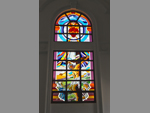 "+
"",
gangaikondacholapurambengali : "গঙ্গাইকোণ্ডাচোলাপুরমঃ-তামিলনাডুর আরিইয়ালুর জেলায় গঙ্গাইকোণ্ডাচোলাপুরম বিখ্যাত তার বৃহদেশ্বর মন্দিরের জন্যে। এটা একটা হিন্দু মন্দির যা শিব ভগবানের উদ্দেশ্যে উৎসর্গ করা হয়েছে। এটা ভারতের অন্যতম বৃহৎ মন্দির ও দ্রাবিড় স্থাপত্যের নির্মাণ রীতি অনুযায়ী তৈরি। ১০৩৫ খৃষ্টাব্দে মন্দিরটা তৈরি করেন চোলা বংশের বিখ্যাত রাজা রাজেন্দ্র চোলা। বর্তমানে ভাঙা দেওয়ালের মাঝখানে এই বিশাল মন্দির দাঁড়িয়ে আছে। মন্দিরের উচ্চতা ১৮০ ফুট। বছরের বিভিন্ন সময়ে এখানে বিভিন্ন অনুষ্ঠান হয় বিশেষতঃ ফেব্রুয়ারি-মার্চ মাসে শিবরাত্রির সময়। ভারতের প্রত্নতাত্ত্বিক সংস্থা এই মন্দিরের দেখভাল করেন। মন্দিরটা ইউনেস্কো ওয়ার্ল্ড হেরিটেজ সাইট হিসাবে ঘোষিত। "+
"Read More..."+
"
"+
"",
gangaikondacholapurambengali : "গঙ্গাইকোণ্ডাচোলাপুরমঃ-তামিলনাডুর আরিইয়ালুর জেলায় গঙ্গাইকোণ্ডাচোলাপুরম বিখ্যাত তার বৃহদেশ্বর মন্দিরের জন্যে। এটা একটা হিন্দু মন্দির যা শিব ভগবানের উদ্দেশ্যে উৎসর্গ করা হয়েছে। এটা ভারতের অন্যতম বৃহৎ মন্দির ও দ্রাবিড় স্থাপত্যের নির্মাণ রীতি অনুযায়ী তৈরি। ১০৩৫ খৃষ্টাব্দে মন্দিরটা তৈরি করেন চোলা বংশের বিখ্যাত রাজা রাজেন্দ্র চোলা। বর্তমানে ভাঙা দেওয়ালের মাঝখানে এই বিশাল মন্দির দাঁড়িয়ে আছে। মন্দিরের উচ্চতা ১৮০ ফুট। বছরের বিভিন্ন সময়ে এখানে বিভিন্ন অনুষ্ঠান হয় বিশেষতঃ ফেব্রুয়ারি-মার্চ মাসে শিবরাত্রির সময়। ভারতের প্রত্নতাত্ত্বিক সংস্থা এই মন্দিরের দেখভাল করেন। মন্দিরটা ইউনেস্কো ওয়ার্ল্ড হেরিটেজ সাইট হিসাবে ঘোষিত। "+
"Read More..."+
" "+
"
"+
" "+
"
"+
" "+
"
"+
" "+
"
"+
" "+
"
"+
" "+
"
"+
" "+
"
"+
" "+
"",
chidambrambengali : "চিদমব্রমঃ-মধ্যপূর্ব তামিলনাডুর কলেরুণ নদীর অববাহিকায় চিদমব্রম একটা অত্যন্ত জনপ্রিয় মন্দির শহর। চিদমব্রমকে বলা হয় থিল্লাই কারণ এখানে থিল্লাই জাতীয় গুল্ম গাছ প্রচুর হয়। এখানকার বিখ্যাত মন্দির হচ্ছে নটরাজ মন্দির। হিন্দুদের শৈবতীর্থ ও বৈষ্ণবতীর্থ হিসাবে চিদমব্রমের খ্যাতি রয়েছে সারা ভারতে। এখানকার মন্দিরের বৈশিষ্ট্য হল যে কোনও ধর্মের, জাতের ও গোষ্ঠীর মানুষজন তাদের ভক্তি নিবেদন করতে পারেন। চিদমব্রমের ঐতিহাসিক ও সাংস্কৃতিক গুরুত্বের বেশিরভাগটাই নটরাজ মন্দিরকে নিয়েই। মন্দিরের জ্ঞান কক্ষে রয়েছে নটরাজ বা শিবের নৃত্যের এক অভিনব ভঙ্গিমা যা মহাজাগতিক শান্তির প্রতীক হিসাবে পরিচিত। অক্ষয় লিঙ্গম, যা শিবের এক অবয়ববিহীন আদিরূপ হিসাবে এটা একটা তীর্থস্থান, তেমনই শিবকে এখানে চিদমবরা রাহাশ্যাম নামে পূজা করা হয়। লোককথা অনুযায়ী পাণ্ডা, পল্লব, চোলা ও বিজয়নগরের রাজারা সবাই এখানে নটরাজের পূজা করতেন। এনারা মন্দিরের সংস্কারের ও সৌন্দর্যের জন্য অনেক কাজ করেছেন। মারাঠি, ফরাসি, ব্রিটিশ ও হায়দার আলি এই মন্দিরকে একটা সেনা ছাউনি হিসাবে প্রায় ৩৫ বছর ব্যবহার করে। ফেব্রুয়ারি মাসে মহাশিবরাত্রিতে এখানে নৃত্যাঞ্জলি অনুষ্ঠান সংগঠিত হয় ও ভারতের বহু নর্তক নর্তকীরা এখানে অংশগ্রহণ করেন। "+
"Read More..."+
"
"+
"",
chidambrambengali : "চিদমব্রমঃ-মধ্যপূর্ব তামিলনাডুর কলেরুণ নদীর অববাহিকায় চিদমব্রম একটা অত্যন্ত জনপ্রিয় মন্দির শহর। চিদমব্রমকে বলা হয় থিল্লাই কারণ এখানে থিল্লাই জাতীয় গুল্ম গাছ প্রচুর হয়। এখানকার বিখ্যাত মন্দির হচ্ছে নটরাজ মন্দির। হিন্দুদের শৈবতীর্থ ও বৈষ্ণবতীর্থ হিসাবে চিদমব্রমের খ্যাতি রয়েছে সারা ভারতে। এখানকার মন্দিরের বৈশিষ্ট্য হল যে কোনও ধর্মের, জাতের ও গোষ্ঠীর মানুষজন তাদের ভক্তি নিবেদন করতে পারেন। চিদমব্রমের ঐতিহাসিক ও সাংস্কৃতিক গুরুত্বের বেশিরভাগটাই নটরাজ মন্দিরকে নিয়েই। মন্দিরের জ্ঞান কক্ষে রয়েছে নটরাজ বা শিবের নৃত্যের এক অভিনব ভঙ্গিমা যা মহাজাগতিক শান্তির প্রতীক হিসাবে পরিচিত। অক্ষয় লিঙ্গম, যা শিবের এক অবয়ববিহীন আদিরূপ হিসাবে এটা একটা তীর্থস্থান, তেমনই শিবকে এখানে চিদমবরা রাহাশ্যাম নামে পূজা করা হয়। লোককথা অনুযায়ী পাণ্ডা, পল্লব, চোলা ও বিজয়নগরের রাজারা সবাই এখানে নটরাজের পূজা করতেন। এনারা মন্দিরের সংস্কারের ও সৌন্দর্যের জন্য অনেক কাজ করেছেন। মারাঠি, ফরাসি, ব্রিটিশ ও হায়দার আলি এই মন্দিরকে একটা সেনা ছাউনি হিসাবে প্রায় ৩৫ বছর ব্যবহার করে। ফেব্রুয়ারি মাসে মহাশিবরাত্রিতে এখানে নৃত্যাঞ্জলি অনুষ্ঠান সংগঠিত হয় ও ভারতের বহু নর্তক নর্তকীরা এখানে অংশগ্রহণ করেন। "+
"Read More..."+
" "+
"
"+
" "+
"
"+
" "+
"
"+
" "+
"
"+
"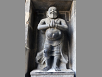 "+
"
"+
" "+
"
"+
" "+
"
"+
" "+
"",
parangipettaibengali : "পারাঙ্গিপেট্টাইঃ-পারাঙ্গিপেট্টাই বা পোর্টো নোভো তামিলনাডুর কুড্ডালোর জেলার করমণ্ডল উপকূলের ভেল্লার নদীর মোহনায় অবস্থিত একটা সমুদ্রতীরবর্তী অদ্ভুত খেয়ালী জনপদ। এই সমুদ্রতীরবর্তী গ্রামে রয়েছে অনেক চিত্তাকর্ষক পুরোনো ও নতুন ইতিহাস। পুরোনো এই ঔপনিবেশিক শহরের রাস্তা দিয়ে চলতে চলতে অনুভব করা যায় পুরোনো ইতিহাসের স্বাদ, বাতাসে ভাসে তার ঐতিহ্যের খুসবু। পারাঙ্গিপেট্টির অর্থ বিদেশীদের জায়গা। ঔপনিবেশিক আমলে এই এলাকা একটা গুরুত্বপূর্ণ বাণিজ্যিক কেন্দ্র ছিল। পর্তুগীজরাই প্রথম ইউরোপীয় যারা এখানে উপনিবেশ স্থাপন করে ও পরে তা ডাচেদের হাতে যায় এবং সর্বশেষে ব্রিটিশদের হাতে আসে ১৮২৪ সালে। জনপদে মুসলিম ধর্মাবলম্বীদের আধিক্য বেশি যারা মাছের ব্যবসা করে। পোর্টো নোভো নামটা দেয় পর্তুগীজরা যারা এই অঞ্চল শাসন করতো ষোড়শ শতাব্দীর প্রথম দিক থেকে অষ্টাদশ শতাব্দীর প্রথমভাগ অব্ধি। ব্রিটিশরা তাদের পরাজিত করে এই অঞ্চলের দখল নেয় ১৮২৪ সালে। মোঘলরা এখানকার নাম দিয়েছিল মামুদ ভান্তার। ব্রিটিশ আমলে এটা একটা শিল্পাঞ্চল ছিল ও এখানকার লোহার জিনিস ব্রিটেনে রপ্তানি করা হতো। এখানে ব্রিটিশদের সঙ্গে মহীশুরের রাজা হায়দার আলির যুদ্ধ হয় ১৭৮১ সালে ও ব্রিটিশরা জয়ী হয়। "+
"Read More..."+
"
"+
"",
parangipettaibengali : "পারাঙ্গিপেট্টাইঃ-পারাঙ্গিপেট্টাই বা পোর্টো নোভো তামিলনাডুর কুড্ডালোর জেলার করমণ্ডল উপকূলের ভেল্লার নদীর মোহনায় অবস্থিত একটা সমুদ্রতীরবর্তী অদ্ভুত খেয়ালী জনপদ। এই সমুদ্রতীরবর্তী গ্রামে রয়েছে অনেক চিত্তাকর্ষক পুরোনো ও নতুন ইতিহাস। পুরোনো এই ঔপনিবেশিক শহরের রাস্তা দিয়ে চলতে চলতে অনুভব করা যায় পুরোনো ইতিহাসের স্বাদ, বাতাসে ভাসে তার ঐতিহ্যের খুসবু। পারাঙ্গিপেট্টির অর্থ বিদেশীদের জায়গা। ঔপনিবেশিক আমলে এই এলাকা একটা গুরুত্বপূর্ণ বাণিজ্যিক কেন্দ্র ছিল। পর্তুগীজরাই প্রথম ইউরোপীয় যারা এখানে উপনিবেশ স্থাপন করে ও পরে তা ডাচেদের হাতে যায় এবং সর্বশেষে ব্রিটিশদের হাতে আসে ১৮২৪ সালে। জনপদে মুসলিম ধর্মাবলম্বীদের আধিক্য বেশি যারা মাছের ব্যবসা করে। পোর্টো নোভো নামটা দেয় পর্তুগীজরা যারা এই অঞ্চল শাসন করতো ষোড়শ শতাব্দীর প্রথম দিক থেকে অষ্টাদশ শতাব্দীর প্রথমভাগ অব্ধি। ব্রিটিশরা তাদের পরাজিত করে এই অঞ্চলের দখল নেয় ১৮২৪ সালে। মোঘলরা এখানকার নাম দিয়েছিল মামুদ ভান্তার। ব্রিটিশ আমলে এটা একটা শিল্পাঞ্চল ছিল ও এখানকার লোহার জিনিস ব্রিটেনে রপ্তানি করা হতো। এখানে ব্রিটিশদের সঙ্গে মহীশুরের রাজা হায়দার আলির যুদ্ধ হয় ১৭৮১ সালে ও ব্রিটিশরা জয়ী হয়। "+
"Read More..."+
" "+
"
"+
" "+
"
"+
" "+
"",
tiruvannamalaibengali : "তিরুভান্নামালাইঃ-তিরুভান্নামালাই জেলা গর্ব করে তার চিরন্তন শান্তি ও ঐশ্বরিক ভাবাবেগের জন্যে। পবিত্র অরুণাচলেশ্বর মন্দির সেখানকার একটা অন্যতম সম্পদ যা তিরুভান্নামালাইকে করেছে আকর্ষণের কেন্দ্রবিন্দু। এটা তামিলনাডুর একটা অন্যতম তীর্থ জনপদ। তিরু কথার অর্থ মর্যাদাসম্পন্ন ও আন্নামালাই কথার অর্থ দুষ্প্রবেশ্য পর্বতমালা। ভারতে শৈব ধর্মের বহু পুরানো হেরিটেজ হচ্ছে তিরুভান্নামালাই। মন্দিরের উচ্চতা ৬১ মিটার ও ১১ টা তলা আছে। রয়েছে ১০০০ পিলারের মণ্ডপ। অরুণাচল পর্বতমালা ও পারিপার্শ্বিক পরিবেশ তামিলদের কাছে অত্যন্ত পবিত্র। অরুণাচলেশ্বর মন্দিরের বিগ্রহ কে বলা হয় তেজো লিঙ্গম অর্থাৎ এটা অগ্নি দেবতার নামে উৎসর্গ করা হয়েছে। মন্দিরের কারুশিল্পের কল্পনা, পরিবেশের সঙ্গে ভীষণ মানানসই যা মন্দিরের গড়নে অন্য মাত্রা এনে দিয়েছে। নভেম্বর-ডিসেম্বর মাসে পূর্ণিমার দিন এখানে দ্বীপম উৎসব পালিত হয় যখন সারা তামিলনাডুর মানুষজন এতে সামিল হ’ন। মন্দিরে ছবি তোলা একেবারে নিষিদ্ধ। "+
"Read More..."+
"
"+
"",
tiruvannamalaibengali : "তিরুভান্নামালাইঃ-তিরুভান্নামালাই জেলা গর্ব করে তার চিরন্তন শান্তি ও ঐশ্বরিক ভাবাবেগের জন্যে। পবিত্র অরুণাচলেশ্বর মন্দির সেখানকার একটা অন্যতম সম্পদ যা তিরুভান্নামালাইকে করেছে আকর্ষণের কেন্দ্রবিন্দু। এটা তামিলনাডুর একটা অন্যতম তীর্থ জনপদ। তিরু কথার অর্থ মর্যাদাসম্পন্ন ও আন্নামালাই কথার অর্থ দুষ্প্রবেশ্য পর্বতমালা। ভারতে শৈব ধর্মের বহু পুরানো হেরিটেজ হচ্ছে তিরুভান্নামালাই। মন্দিরের উচ্চতা ৬১ মিটার ও ১১ টা তলা আছে। রয়েছে ১০০০ পিলারের মণ্ডপ। অরুণাচল পর্বতমালা ও পারিপার্শ্বিক পরিবেশ তামিলদের কাছে অত্যন্ত পবিত্র। অরুণাচলেশ্বর মন্দিরের বিগ্রহ কে বলা হয় তেজো লিঙ্গম অর্থাৎ এটা অগ্নি দেবতার নামে উৎসর্গ করা হয়েছে। মন্দিরের কারুশিল্পের কল্পনা, পরিবেশের সঙ্গে ভীষণ মানানসই যা মন্দিরের গড়নে অন্য মাত্রা এনে দিয়েছে। নভেম্বর-ডিসেম্বর মাসে পূর্ণিমার দিন এখানে দ্বীপম উৎসব পালিত হয় যখন সারা তামিলনাডুর মানুষজন এতে সামিল হ’ন। মন্দিরে ছবি তোলা একেবারে নিষিদ্ধ। "+
"Read More..."+
" "+
"
"+
" "+
"
"+
" "+
"
"+
" "+
"
"+
" "+
"
"+
" "+
"
"+
" "+
"
"+
" "+
"",
ginjeebengali : "গিঞ্জিঃ-তামিলনাডুর ভিল্লুপূরম জেলায় অবস্থিত গিঞ্জি বা সিঞ্জি ফোর্ট দক্ষিণ ভারতের এক অন্যতম ফোর্ট যা এখনও টিকে আছে। গিঞ্জি ফোর্ট তৈরি হয়েছে তিনটে ছোট ছোট পাহাড়ের ওপর। উত্তরে কৃষ্ণগিরি, পশ্চিমে রাজগিরি ও দক্ষিণপূর্বে চন্দ্রয়ানদুর্গ। এই তিনটে পাহাড়ের ওপর তৈরি হয়েছে পুরো ফোর্টটা কিন্তু প্রত্যেকের নিজস্ব আলাদা আলাদা সিটাডেল রয়েছে। এগুলোকে একসঙ্গে জুড়ে তৈরি হয়েছে এক বিশাল ত্রিভুজ যা উত্তর থেকে দক্ষিণে প্রায় এক মাইল আর বিরামচিহ্নের মতো স্থানে স্থানে রয়েছে সামরিক নিরাপত্তামূলক ব্যবস্থা ও ফটক যার ফলে ভেতর থেকেই একে অপরের সঙ্গে যোগাযোগ রাখতে পারে। ফোর্টটা এত মজবুত করে তৈরি যে প্রবল প্রতাপশালী মারাঠি রাজা শিবাজীও বলেছিলেন যে ‘ভারতের অন্যতম দুর্ভেদ্য ফোর্ট’। ফোর্টের ভেতর রয়েছে পাথরে খোদাই করা জৈন সন্ন্যাসী চন্দ্রনান্দীর মূর্তি যিনি ২৪ জৈন তীর্থঙ্করের অন্যতম। ভারতের প্রত্নতাত্ত্বিক বিশ্লেষণ অনুযায়ী খৃষ্টপূর্ব ২০০ সাল থেকে ৫০০ খৃষ্টাব্দ অব্ধি জৈনরা এখানে বাস করতেন। "+
"Read More..."+
"
"+
"",
ginjeebengali : "গিঞ্জিঃ-তামিলনাডুর ভিল্লুপূরম জেলায় অবস্থিত গিঞ্জি বা সিঞ্জি ফোর্ট দক্ষিণ ভারতের এক অন্যতম ফোর্ট যা এখনও টিকে আছে। গিঞ্জি ফোর্ট তৈরি হয়েছে তিনটে ছোট ছোট পাহাড়ের ওপর। উত্তরে কৃষ্ণগিরি, পশ্চিমে রাজগিরি ও দক্ষিণপূর্বে চন্দ্রয়ানদুর্গ। এই তিনটে পাহাড়ের ওপর তৈরি হয়েছে পুরো ফোর্টটা কিন্তু প্রত্যেকের নিজস্ব আলাদা আলাদা সিটাডেল রয়েছে। এগুলোকে একসঙ্গে জুড়ে তৈরি হয়েছে এক বিশাল ত্রিভুজ যা উত্তর থেকে দক্ষিণে প্রায় এক মাইল আর বিরামচিহ্নের মতো স্থানে স্থানে রয়েছে সামরিক নিরাপত্তামূলক ব্যবস্থা ও ফটক যার ফলে ভেতর থেকেই একে অপরের সঙ্গে যোগাযোগ রাখতে পারে। ফোর্টটা এত মজবুত করে তৈরি যে প্রবল প্রতাপশালী মারাঠি রাজা শিবাজীও বলেছিলেন যে ‘ভারতের অন্যতম দুর্ভেদ্য ফোর্ট’। ফোর্টের ভেতর রয়েছে পাথরে খোদাই করা জৈন সন্ন্যাসী চন্দ্রনান্দীর মূর্তি যিনি ২৪ জৈন তীর্থঙ্করের অন্যতম। ভারতের প্রত্নতাত্ত্বিক বিশ্লেষণ অনুযায়ী খৃষ্টপূর্ব ২০০ সাল থেকে ৫০০ খৃষ্টাব্দ অব্ধি জৈনরা এখানে বাস করতেন। "+
"Read More..."+
" "+
"
"+
" "+
"
"+
" "+
"
"+
" "+
"
"+
" "+
"
"+
" "+
"
"+
" "+
"
"+
" "+
"",
pondicherrybengali : "পণ্ডিচেরীঃ-প্রস্ফুটিত কাগজ ফুলের গাছ, ভাঙাচোরা গির্জা, বৃক্ষরাজি শোভিত রাজপথ ও অষ্টাদশ শতাব্দীর ঔপনিবেশিক অট্টালিকা, রাঙিয়ে রেখেছে বঙ্গোপসাগরের তীরে ফরাসি উপনিবেশ পন্ডিচেরীকে। ফরাসি উপনিবেশ হলেও এখানে সারা বছরই অনুষ্ঠিত হয় বিভিন্ন রকমের ভারতীয় সাংস্কৃতিক অনুষ্ঠান ও প্রতিদিন শ্রী অরবিন্দ আশ্রমের বিভিন্ন ধর্মীয় অনুষ্ঠান তো রয়েছেই। রয়েছে উত্তর থেকে দক্ষিণ অব্ধি বিস্তৃত শান্ত সমুদ্রসৈকত ও সূর্যোদয়ের অপরূপ শোভা। পন্ডিচেরীর ইতিহাস পাওয়া যায় চতুর্থ শতাব্দী থেকে যখন এটা কাঞ্চিপূরমের পল্লব রাজাদের অধীনে ছিল। পরবর্তী কয়েক শতাব্দী ধরে দাক্ষিণাত্যের বিভিন্ন রাজারা পন্ডিচেরী শাসন করেন। তাঞ্জাভুরের চোলা রাজারা দশম শতাব্দীতে এখানকার দখল নেন। পরবর্তীকালে বিজয়নগরের সুলতানরা এর দখল নেয় যা প্রায় ১৬৩৮ সাল অব্ধি কায়েম ছিল। পন্ডিচেরী গুরুত্ব পায় ফরাসি আমলে যখন ফরাসি ইষ্ট ইণ্ডিয়া কোম্পানি ১৬৭৪ সালে এখানে একটা ব্যবসায়িক কেন্দ্র গড়ে তোলে। ফলে এই অঞ্চল ফরাসি উপনিবেশের অন্যতম প্রধান কেন্দ্র হয়ে ওঠে। ডাচ ও ব্রিটিশ কোম্পানিগুলোও এখানে ব্যবসা করতে আগ্রহী হয়, ফলে এই ইউরোপীয় কোম্পানিগুলো নিজেদের মধ্যে যুদ্ধে জড়িয়ে পড়ে। ১৬৯৩ সালে ডাচরা পন্ডিচেরী দখল করে তবে নেদারল্যান্ডে রেসউইক চুক্তি অনুযায়ী ১৬৯৯ সালে আবার ফরাসিদের ফেরত দিয়ে দেয়। পরবর্তীকালে ডাচরা বর্তমান ভিলুপ্পুরম ও নাগাপাট্টিনাম জেলার প্রায় পুরোটাই দখল করে নেয়। ব্রিটিশরা পন্ডিচেরী দখল করে ১৭৬১ সালে কিন্তু প্যারিস চুক্তি অনুযায়ী তা আবার ফেরত দিয়ে দেয় ১৭৬৩ সালে। ১৭৮৯ সালে রাজতন্ত্রের বিরুদ্ধে ফরাসি বিপ্লবের সময়, ব্রিটিশরা ১৭৯৩ সালে আবার পন্ডিচেরী দখল করে। কিন্তু তা আবারও ফেরত দেয় ১৮১৪ সালে যখন তারা প্রায় পুরো ভারতের দখল নেয়। ১৯৫৪ সালে ফরাসি উপনিবেশ ভারত থেকে হাত ওঠায়। "+
"Read More..."+
"
"+
"",
pondicherrybengali : "পণ্ডিচেরীঃ-প্রস্ফুটিত কাগজ ফুলের গাছ, ভাঙাচোরা গির্জা, বৃক্ষরাজি শোভিত রাজপথ ও অষ্টাদশ শতাব্দীর ঔপনিবেশিক অট্টালিকা, রাঙিয়ে রেখেছে বঙ্গোপসাগরের তীরে ফরাসি উপনিবেশ পন্ডিচেরীকে। ফরাসি উপনিবেশ হলেও এখানে সারা বছরই অনুষ্ঠিত হয় বিভিন্ন রকমের ভারতীয় সাংস্কৃতিক অনুষ্ঠান ও প্রতিদিন শ্রী অরবিন্দ আশ্রমের বিভিন্ন ধর্মীয় অনুষ্ঠান তো রয়েছেই। রয়েছে উত্তর থেকে দক্ষিণ অব্ধি বিস্তৃত শান্ত সমুদ্রসৈকত ও সূর্যোদয়ের অপরূপ শোভা। পন্ডিচেরীর ইতিহাস পাওয়া যায় চতুর্থ শতাব্দী থেকে যখন এটা কাঞ্চিপূরমের পল্লব রাজাদের অধীনে ছিল। পরবর্তী কয়েক শতাব্দী ধরে দাক্ষিণাত্যের বিভিন্ন রাজারা পন্ডিচেরী শাসন করেন। তাঞ্জাভুরের চোলা রাজারা দশম শতাব্দীতে এখানকার দখল নেন। পরবর্তীকালে বিজয়নগরের সুলতানরা এর দখল নেয় যা প্রায় ১৬৩৮ সাল অব্ধি কায়েম ছিল। পন্ডিচেরী গুরুত্ব পায় ফরাসি আমলে যখন ফরাসি ইষ্ট ইণ্ডিয়া কোম্পানি ১৬৭৪ সালে এখানে একটা ব্যবসায়িক কেন্দ্র গড়ে তোলে। ফলে এই অঞ্চল ফরাসি উপনিবেশের অন্যতম প্রধান কেন্দ্র হয়ে ওঠে। ডাচ ও ব্রিটিশ কোম্পানিগুলোও এখানে ব্যবসা করতে আগ্রহী হয়, ফলে এই ইউরোপীয় কোম্পানিগুলো নিজেদের মধ্যে যুদ্ধে জড়িয়ে পড়ে। ১৬৯৩ সালে ডাচরা পন্ডিচেরী দখল করে তবে নেদারল্যান্ডে রেসউইক চুক্তি অনুযায়ী ১৬৯৯ সালে আবার ফরাসিদের ফেরত দিয়ে দেয়। পরবর্তীকালে ডাচরা বর্তমান ভিলুপ্পুরম ও নাগাপাট্টিনাম জেলার প্রায় পুরোটাই দখল করে নেয়। ব্রিটিশরা পন্ডিচেরী দখল করে ১৭৬১ সালে কিন্তু প্যারিস চুক্তি অনুযায়ী তা আবার ফেরত দিয়ে দেয় ১৭৬৩ সালে। ১৭৮৯ সালে রাজতন্ত্রের বিরুদ্ধে ফরাসি বিপ্লবের সময়, ব্রিটিশরা ১৭৯৩ সালে আবার পন্ডিচেরী দখল করে। কিন্তু তা আবারও ফেরত দেয় ১৮১৪ সালে যখন তারা প্রায় পুরো ভারতের দখল নেয়। ১৯৫৪ সালে ফরাসি উপনিবেশ ভারত থেকে হাত ওঠায়। "+
"Read More..."+
" "+
"
"+
" "+
"
"+
" "+
"
"+
" "+
"
"+
" "+
"
"+
" "+
"
"+
" "+
"
"+
" "+
"",
yalagiribengali : "ইয়ালাগিরিঃ-জাভাডু পাহাড়, পালামাথি পাহাড়, স্বামীমালাই পাহাড় ও জলাগামপাড়াই পাহাড়, এই চারটে পাহাড় নিয়ে তৈরি হয়েছে তামিলনাডুর ভেলোর জেলার এক অত্যন্ত সুন্দর ও স্বাস্থ্যকর পাহাড়ি জনপদ ইয়ালাগিরি। ৩০ স্কো. কি.মি. বিস্তৃত এই জনপদের উচ্চতা ১,৪১০ মিটার ও সর্বোচ্চ পর্বত শিখর স্বামীমালাইয়ের উচ্চতা ৪,৩৩৮ ফুট। ইয়ালাগিরি পর্যটকদের জন্য নতুন হলেও এখানে প্রায় ২০০ বছর আগে থেকে জনবসতি রয়েছে, যদিও তা মূলত আদিবাসী সম্প্রদায়ের। ১৪টা গ্রাম নিয়ে তৈরি এই জনপদের মানুষজনের জীবিকা, কৃষি, ফুল চাষ ও অন্যান্য বনজ সম্পদের ওপর নির্ভরশীল। সবুজে মোড়া এই উপত্যকা একসময় ইয়ালাগিরির জমিদারদের ব্যক্তিগত সম্পত্তি ছিল। ১৯৫০ সালে সরকার তা অধিগ্রহণ করে নেয়। জমিদাররা এখনও বর্তমান কিন্তু তারা রেড্ডিয়ুর নামে এক জায়গায় বসবাস করে। এই এলাকা ট্রেকারদের স্বর্গরাজ্য। গোটা এলাকায় ছড়িয়ে ছিটিয়ে রয়েছে ছোট বড় অনেক আকর্ষণীয় ট্রেকিং রুট যা অ্যাডভেঞ্চার প্রিয় মানুষদের আকৃষ্ট করে। ইয়ালাগিরির সপ্নালস পাহাড়ি দৃশ্যপটের রাস্তায় ২০টা হেয়ারপিন বাঁক আছে। প্রতিটা বাঁক থেকেই মনে হবে, শহরের ব্যস্ততা ও কৃত্রিমতা আমাদের থেকে একটু একটু করে দূরে সরে যাচ্ছে। এখানে পৌঁছে প্রথমেই যা পাওয়া যাবে তা হল অকৃত্রিম পারিপার্শ্বিকতা ও অনন্যসাধারণ শান্ত পরিবেশ। শোনা যাবে সকাল সন্ধ্যায় টুং-টাং করে বেজে ওঠা মন্দিরের ঘণ্টার আওয়াজ, পাওয়া যাবে তরতাজা ফুলের সুরভি, শ্রবণেন্দ্রিয়ে বাজবে বহু রকমের পাখির কাকলি আর পাওয়া যাবে সরল সাদাসিধে পল্লীগ্রামের আদিবাসী মানুষজনের সান্নিধ্য। সকালে বিকালে লেকের ধারে একটু হেঁটে বা হাল্কা ট্রেকে জঙ্গলের পথে সূর্যাস্ত দেখে বা স্নিগ্ধ রাত্রে তারার দিকে তাকিয়ে কেটে যাবে বেশ কিছু সময়। তখন আস্তে আস্তে অনুভব করা যাবে প্রকৃতি পরিচয়টা আসলে কি। "+
"Read More..."+
"
"+
"",
yalagiribengali : "ইয়ালাগিরিঃ-জাভাডু পাহাড়, পালামাথি পাহাড়, স্বামীমালাই পাহাড় ও জলাগামপাড়াই পাহাড়, এই চারটে পাহাড় নিয়ে তৈরি হয়েছে তামিলনাডুর ভেলোর জেলার এক অত্যন্ত সুন্দর ও স্বাস্থ্যকর পাহাড়ি জনপদ ইয়ালাগিরি। ৩০ স্কো. কি.মি. বিস্তৃত এই জনপদের উচ্চতা ১,৪১০ মিটার ও সর্বোচ্চ পর্বত শিখর স্বামীমালাইয়ের উচ্চতা ৪,৩৩৮ ফুট। ইয়ালাগিরি পর্যটকদের জন্য নতুন হলেও এখানে প্রায় ২০০ বছর আগে থেকে জনবসতি রয়েছে, যদিও তা মূলত আদিবাসী সম্প্রদায়ের। ১৪টা গ্রাম নিয়ে তৈরি এই জনপদের মানুষজনের জীবিকা, কৃষি, ফুল চাষ ও অন্যান্য বনজ সম্পদের ওপর নির্ভরশীল। সবুজে মোড়া এই উপত্যকা একসময় ইয়ালাগিরির জমিদারদের ব্যক্তিগত সম্পত্তি ছিল। ১৯৫০ সালে সরকার তা অধিগ্রহণ করে নেয়। জমিদাররা এখনও বর্তমান কিন্তু তারা রেড্ডিয়ুর নামে এক জায়গায় বসবাস করে। এই এলাকা ট্রেকারদের স্বর্গরাজ্য। গোটা এলাকায় ছড়িয়ে ছিটিয়ে রয়েছে ছোট বড় অনেক আকর্ষণীয় ট্রেকিং রুট যা অ্যাডভেঞ্চার প্রিয় মানুষদের আকৃষ্ট করে। ইয়ালাগিরির সপ্নালস পাহাড়ি দৃশ্যপটের রাস্তায় ২০টা হেয়ারপিন বাঁক আছে। প্রতিটা বাঁক থেকেই মনে হবে, শহরের ব্যস্ততা ও কৃত্রিমতা আমাদের থেকে একটু একটু করে দূরে সরে যাচ্ছে। এখানে পৌঁছে প্রথমেই যা পাওয়া যাবে তা হল অকৃত্রিম পারিপার্শ্বিকতা ও অনন্যসাধারণ শান্ত পরিবেশ। শোনা যাবে সকাল সন্ধ্যায় টুং-টাং করে বেজে ওঠা মন্দিরের ঘণ্টার আওয়াজ, পাওয়া যাবে তরতাজা ফুলের সুরভি, শ্রবণেন্দ্রিয়ে বাজবে বহু রকমের পাখির কাকলি আর পাওয়া যাবে সরল সাদাসিধে পল্লীগ্রামের আদিবাসী মানুষজনের সান্নিধ্য। সকালে বিকালে লেকের ধারে একটু হেঁটে বা হাল্কা ট্রেকে জঙ্গলের পথে সূর্যাস্ত দেখে বা স্নিগ্ধ রাত্রে তারার দিকে তাকিয়ে কেটে যাবে বেশ কিছু সময়। তখন আস্তে আস্তে অনুভব করা যাবে প্রকৃতি পরিচয়টা আসলে কি। "+
"Read More..."+
" "+
"
"+
" "+
"
"+
" "+
"
"+
" "+
"
"+
" "+
"
"+
" "+
"
"+
" "+
"
"+
" "+
"",
vellorebengali : "ভেলোরঃ-ভেলোর কথার অর্থ ‘যুদ্ধের শহর’। তামিলনাডুর উত্তরে ঘন জঙ্গলাকীর্ণ পূর্বঘাট পর্বতমালার ঢালে, পালার নদীর তীরে এক শান্ত অঞ্চলে ভেলোর জেলা অবস্থিত, যার সদর দফতর হচ্ছে ভেলোর শহর। অঞ্চলটা বর্তমানে শান্ত হলেও এই অঞ্চল বহু যুদ্ধের সাক্ষী। ছোট্ট এই শহরকে ঘিরে রেখেছে পূর্বঘাট পর্বতমালার বিভিন্ন ছোট বড় পাহাড়ের শ্রেণী। ভেলোরকে সবাই চেনে খৃষ্টান মিশনারি চিকিৎসক ডাঃ ইডা স্কুড্ডারের মেডিকেল কলেজে ও অসাধারণ সুন্দর এক ফোটের জন্যে। এই বিশ্বমানের মেডিকেল কলেজ ভারতবর্ষের সেরা চিকিৎসা কেন্দ্র। ত্রয়োদশ শতাব্দীর শেষভাগে ভেলোর ফোর্ট তৈরি করেন বিজয়নগরের রাজারা। ভারতের দক্ষিণভাগে ভেলোর ফোর্ট মিলিটারি স্থাপত্যবিদ্যার এক শ্রেষ্ঠ নিদর্শন। দেওয়াল ঘেরা অংশে রয়েছে বহু বড় বড় অট্টালিকা ও চমৎকার জলকান্তেশ্বর মন্দির। ফোটের অন্যান্য অংশের মতো এই শিব মন্দিরও অত্যন্ত সুন্দরভাবে সংরক্ষিত। সাততলা গোপুরাম মন্দিরও যথেষ্ট সুন্দর ও পার্শ্বদেশে রয়েছে নৃত্যরত পার্বতী। মন্দিরের ভেতরের থামগুলো সুন্দরভাবে খোদাই করা ও ঘোড়ার ওপর উপবিষ্ট মানবাকৃতির চিহ্ন, বিজয়নগরের চারুকলার সর্বোত্তম উদাহরণ। উঠোনের মধ্যে রয়েছে শিবের বাহন নন্দী। "+
"Read More..."+
"
"+
"",
vellorebengali : "ভেলোরঃ-ভেলোর কথার অর্থ ‘যুদ্ধের শহর’। তামিলনাডুর উত্তরে ঘন জঙ্গলাকীর্ণ পূর্বঘাট পর্বতমালার ঢালে, পালার নদীর তীরে এক শান্ত অঞ্চলে ভেলোর জেলা অবস্থিত, যার সদর দফতর হচ্ছে ভেলোর শহর। অঞ্চলটা বর্তমানে শান্ত হলেও এই অঞ্চল বহু যুদ্ধের সাক্ষী। ছোট্ট এই শহরকে ঘিরে রেখেছে পূর্বঘাট পর্বতমালার বিভিন্ন ছোট বড় পাহাড়ের শ্রেণী। ভেলোরকে সবাই চেনে খৃষ্টান মিশনারি চিকিৎসক ডাঃ ইডা স্কুড্ডারের মেডিকেল কলেজে ও অসাধারণ সুন্দর এক ফোটের জন্যে। এই বিশ্বমানের মেডিকেল কলেজ ভারতবর্ষের সেরা চিকিৎসা কেন্দ্র। ত্রয়োদশ শতাব্দীর শেষভাগে ভেলোর ফোর্ট তৈরি করেন বিজয়নগরের রাজারা। ভারতের দক্ষিণভাগে ভেলোর ফোর্ট মিলিটারি স্থাপত্যবিদ্যার এক শ্রেষ্ঠ নিদর্শন। দেওয়াল ঘেরা অংশে রয়েছে বহু বড় বড় অট্টালিকা ও চমৎকার জলকান্তেশ্বর মন্দির। ফোটের অন্যান্য অংশের মতো এই শিব মন্দিরও অত্যন্ত সুন্দরভাবে সংরক্ষিত। সাততলা গোপুরাম মন্দিরও যথেষ্ট সুন্দর ও পার্শ্বদেশে রয়েছে নৃত্যরত পার্বতী। মন্দিরের ভেতরের থামগুলো সুন্দরভাবে খোদাই করা ও ঘোড়ার ওপর উপবিষ্ট মানবাকৃতির চিহ্ন, বিজয়নগরের চারুকলার সর্বোত্তম উদাহরণ। উঠোনের মধ্যে রয়েছে শিবের বাহন নন্দী। "+
"Read More..."+
" "+
"
"+
" "+
"
"+
" "+
"
"+
" "+
"
"+
"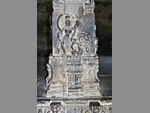 "+
"
"+
" "+
"
"+
" "+
"
"+
" "+
"",
mahabalipurambengali : "মহাবলীপূরমঃ-করমণ্ডল সমুদ্র উপকূল বরাবর বঙ্গোপসাগরের তীরে মহাবলীপূরম তামিলনাডুর একটা অসম্ভব সুন্দর পর্যটন কেন্দ্র, যেখানে রয়েছে নজরকাড়া ঐতিহাসিক মনুমেন্ট, বিচিত্র ভাস্কর্য, চমৎকার সমুদ্রসৈকত, উন্নতমানের সংস্কৃতি ও সনাতনী ঐতিহ্য। দক্ষিণভারতের তামিলনাডু ভ্রমণে মহাবলীপূরম একটা অবশ্য দর্শনীয় ভ্রমণ ঠিকানা। মহাবলীপূরম নামটা এসেছে একটা রূপকথা থেকে। এই এলাকা শাসন করতো এক অত্যন্ত নিষ্ঠুর রাজা যার নাম মহাবলী, যে পরবর্তীকালে ভগবান বিষ্ণুর হাতে নিহত হয়। সেই রাজার নামেই এই জায়গার নাম মহাবলীপূরম হয়েছে। এখানে পল্লব রাজারা ৬৫০ থেকে ৭৫০ সাল অব্ধি রাজত্ব করেন ও সেই সময়কে পল্লবদের স্বর্ণযুগ বলা হয়। এই সময়েই বিকাশ লাভ করে বিখ্যাত কবি, মহান সিদ্ধপুরুষ, দক্ষ কারিগর ও প্রতিভাবান নাট্যকার। মহাবলীপূরমে রয়েছে অনন্য ভাস্কর্য ও চিত্রকলা যা তখনকার প্রতিভা ও দক্ষতার পরিচয় বহন করে। নতুন নতুন স্থাপত্যশৈলীর সৃষ্টি ও প্রবর্তন, এককথায় চারুকলার সর্বোৎকৃষ্ট উদাহরণ। মহাবলীপূরমের মন্দিরগুলো একখণ্ড পাথর থেকে তৈরি। দুটো অনুচ্চ পাহাড়ের দুদিকে বিভিন্ন মন্দির রয়েছে যাকে বলা হয় মণ্ডপ। রয়েছে অসাধারণ খোদাইয়ের কাজ যেমন নন্দী, সিংহ, হাতি ও মন্দিরের এই অংশকে বলা হয় রথ। এখানে প্রতিবছর শীতকালে নৃত্য উৎসব অনুষ্ঠিত হয় ও সারা ভারতের বিভিন্ন নৃত্য পরিবেশনা হয় যেমন ভরতনট্টম, কুচিপুডি, কথাকলি ও ওড়িয়া। "+
"Read More..."+
"
"+
"",
mahabalipurambengali : "মহাবলীপূরমঃ-করমণ্ডল সমুদ্র উপকূল বরাবর বঙ্গোপসাগরের তীরে মহাবলীপূরম তামিলনাডুর একটা অসম্ভব সুন্দর পর্যটন কেন্দ্র, যেখানে রয়েছে নজরকাড়া ঐতিহাসিক মনুমেন্ট, বিচিত্র ভাস্কর্য, চমৎকার সমুদ্রসৈকত, উন্নতমানের সংস্কৃতি ও সনাতনী ঐতিহ্য। দক্ষিণভারতের তামিলনাডু ভ্রমণে মহাবলীপূরম একটা অবশ্য দর্শনীয় ভ্রমণ ঠিকানা। মহাবলীপূরম নামটা এসেছে একটা রূপকথা থেকে। এই এলাকা শাসন করতো এক অত্যন্ত নিষ্ঠুর রাজা যার নাম মহাবলী, যে পরবর্তীকালে ভগবান বিষ্ণুর হাতে নিহত হয়। সেই রাজার নামেই এই জায়গার নাম মহাবলীপূরম হয়েছে। এখানে পল্লব রাজারা ৬৫০ থেকে ৭৫০ সাল অব্ধি রাজত্ব করেন ও সেই সময়কে পল্লবদের স্বর্ণযুগ বলা হয়। এই সময়েই বিকাশ লাভ করে বিখ্যাত কবি, মহান সিদ্ধপুরুষ, দক্ষ কারিগর ও প্রতিভাবান নাট্যকার। মহাবলীপূরমে রয়েছে অনন্য ভাস্কর্য ও চিত্রকলা যা তখনকার প্রতিভা ও দক্ষতার পরিচয় বহন করে। নতুন নতুন স্থাপত্যশৈলীর সৃষ্টি ও প্রবর্তন, এককথায় চারুকলার সর্বোৎকৃষ্ট উদাহরণ। মহাবলীপূরমের মন্দিরগুলো একখণ্ড পাথর থেকে তৈরি। দুটো অনুচ্চ পাহাড়ের দুদিকে বিভিন্ন মন্দির রয়েছে যাকে বলা হয় মণ্ডপ। রয়েছে অসাধারণ খোদাইয়ের কাজ যেমন নন্দী, সিংহ, হাতি ও মন্দিরের এই অংশকে বলা হয় রথ। এখানে প্রতিবছর শীতকালে নৃত্য উৎসব অনুষ্ঠিত হয় ও সারা ভারতের বিভিন্ন নৃত্য পরিবেশনা হয় যেমন ভরতনট্টম, কুচিপুডি, কথাকলি ও ওড়িয়া। "+
"Read More..."+
" "+
"
"+
" "+
"
"+
" "+
"
"+
" "+
"
"+
" "+
"
"+
" "+
"
"+
" "+
"
"+
" "+
"",
kanchipurambengali : "কাঞ্চিপূরমঃ-তামিলনাডুর উত্তরপূর্ব উপকূলে অবস্থিত কাঞ্চিপূরম জেলার নামেই তৈরি হয়েছে কাঞ্চিপূরম শহর। এই শহরকে বলা হয় ‘হাজার মন্দিরের শহর’। এই শহর তার দ্যুতিময় সংস্কৃতি, হেরিটেজ ও ভারত বিখ্যাত সিল্কের শাড়ির জন্যে পরিচিত। দক্ষিণ ভারতের অন্যতম পুরানো শহর হওয়ার সুবাদে, কাঞ্চিপুরমের ইতিহাস পল্লব রাজাদের আমল থেকে পাওয়া যায়। কাঞ্চিপূরম তার শ্রেষ্ঠত্বের শিখরে ওঠে চতুর্থ থেকে নবম শতাব্দীতে, পল্লব রাজবংশের আমলে। এটা পল্লবদের রাজধানী ছিল। এখানকার বেশিরভাগ মন্দিরই সেই আমলেই তৈরি। কাঞ্চিপূরমকে তামিলনাডুর সাংস্কৃতিক রাজধানী বলা হয় ও এই শহর হিন্দুদের অন্যতম পবিত্র তীর্থস্থান। এখানকার মন্দির, স্মৃতিস্তম্ভ ও অন্যান্য স্থাপত্য দ্রাবিড় রাজাদের অনন্য সৃষ্টি বলে অভিহিত। বিখ্যাত মন্দিরগুলোর মধ্যে শাক্কিশ্বরার মন্দির, বৈকুণ্ঠ পেরিমল মন্দির, কৈলাসনাথ মন্দির, একাম্ববারেশ্বর মন্দির, কমলাক্ষী আম্মান মন্দির ইত্যাদি বিখ্যাত। কাঞ্চিপুরমের সিল্কের শাড়ি ভারত বিখ্যাত। রুচিসম্মত রঙ, ঐতিহ্যবাহী দক্ষিণী কাজ ও মসৃণতার জন্য সারা ভারতব্যাপী এর কদর আছে। "+
"Read More..."+
"
"+
"",
kanchipurambengali : "কাঞ্চিপূরমঃ-তামিলনাডুর উত্তরপূর্ব উপকূলে অবস্থিত কাঞ্চিপূরম জেলার নামেই তৈরি হয়েছে কাঞ্চিপূরম শহর। এই শহরকে বলা হয় ‘হাজার মন্দিরের শহর’। এই শহর তার দ্যুতিময় সংস্কৃতি, হেরিটেজ ও ভারত বিখ্যাত সিল্কের শাড়ির জন্যে পরিচিত। দক্ষিণ ভারতের অন্যতম পুরানো শহর হওয়ার সুবাদে, কাঞ্চিপুরমের ইতিহাস পল্লব রাজাদের আমল থেকে পাওয়া যায়। কাঞ্চিপূরম তার শ্রেষ্ঠত্বের শিখরে ওঠে চতুর্থ থেকে নবম শতাব্দীতে, পল্লব রাজবংশের আমলে। এটা পল্লবদের রাজধানী ছিল। এখানকার বেশিরভাগ মন্দিরই সেই আমলেই তৈরি। কাঞ্চিপূরমকে তামিলনাডুর সাংস্কৃতিক রাজধানী বলা হয় ও এই শহর হিন্দুদের অন্যতম পবিত্র তীর্থস্থান। এখানকার মন্দির, স্মৃতিস্তম্ভ ও অন্যান্য স্থাপত্য দ্রাবিড় রাজাদের অনন্য সৃষ্টি বলে অভিহিত। বিখ্যাত মন্দিরগুলোর মধ্যে শাক্কিশ্বরার মন্দির, বৈকুণ্ঠ পেরিমল মন্দির, কৈলাসনাথ মন্দির, একাম্ববারেশ্বর মন্দির, কমলাক্ষী আম্মান মন্দির ইত্যাদি বিখ্যাত। কাঞ্চিপুরমের সিল্কের শাড়ি ভারত বিখ্যাত। রুচিসম্মত রঙ, ঐতিহ্যবাহী দক্ষিণী কাজ ও মসৃণতার জন্য সারা ভারতব্যাপী এর কদর আছে। "+
"Read More..."+
" "+
"
"+
" "+
"
"+
" "+
"
"+
" "+
"
"+
" "+
"
"+
" "+
"
"+
" "+
"
"+
" "+
"",
chennaibengali : "চেন্নাইঃ-চেন্নাই, তামিলনাডুর রাজধানী ও ভারতের চতুর্থ বৃহত্তম শহর। বঙ্গোপসাগরের করমণ্ডল উপকূলে অবস্থিত চেন্নাইকে বলা হয় দাক্ষিণাত্যের প্রবেশপথ, কারণ এই শহর সংস্কৃতি ও শিক্ষার পীঠস্থান বলে স্বীকৃত। মোটরগাড়ি শিল্পের রাজধানীর সম্মান অর্জন করার সাথে সাথে এই শহর ভারতের তৃতীয় বৃহত্তম বাণিজ্য ও শিল্পের কেন্দ্রস্থল। লোককথা অনুযায়ী চেন্নাইপট্টনাম নামটা আসে চেন্না কেশভা পেরুমাল মন্দিরের নাম থেকে। এটাও লোককথা অনুযায়ীই বলা হয় যে এই অঞ্চলের নাম দামারলা চেন্নাপ্পা নয়াকুডুর নামে তৈরি হয়, যিনি কলাহস্তি ও বিন্দবাসীর নায়েক ছিলেন। ভারতের প্রত্নতাত্ত্বিক বিভাগ চেন্নাইয়ের পল্লভরম থেকে প্রস্তর যুগের বহু কিছু আবিষ্কার করে, যাতে প্রমাণ হয় যে চেন্নাই অঞ্চল মেগালিথিক সংস্কৃতির প্রতিষ্ঠাতা ছিল। চেন্নাইয়ের ইতিহাস পাওয়া যায় প্রথম শতাব্দী থেকে যখন এটা একটা গুরুত্বপূর্ণ অর্থনৈতিক ও মিলিটারি কেন্দ্র ছিল। এই সুন্দর শহরের প্রায় পাঁচ মিলিয়ন মানুষের হৃদয়ে রয়েছে সনাতনী ঐতিহ্যের প্রতি এক প্রগাঢ় ভক্তি ও পরম শ্রদ্ধা। এই সবুজ খোলামেলা শহর সেই সমস্ত পর্যটকদেরই ডাকে যারা অলসভাবে দিন কাটাতে চায়। এটা সেই শহর যার বাসিন্দাদের মধ্যে রয়েছে শিষ্টাচার, আকর্ষণীয়তা, সংস্কৃতি ও মূল্যবোধের এক অপরিমেয় মননশীলতা কিন্তু অদ্ভুতভাবে এই সমস্তই হয়, অত্যন্ত আধুনিক এক বিশ্বজনীন শহরের কর্মব্যস্ততার মধ্যে। মন্দির ও মসজিদ, গির্জা ও দুর্গ, বেলাভূমি ও উদ্যান, স্মৃতিসৌধ ও পুরাকীর্তি এ সবই চেন্নাই শহরের এক একটা সম্পদ। "+
"Read More..."+
"
"+
"",
chennaibengali : "চেন্নাইঃ-চেন্নাই, তামিলনাডুর রাজধানী ও ভারতের চতুর্থ বৃহত্তম শহর। বঙ্গোপসাগরের করমণ্ডল উপকূলে অবস্থিত চেন্নাইকে বলা হয় দাক্ষিণাত্যের প্রবেশপথ, কারণ এই শহর সংস্কৃতি ও শিক্ষার পীঠস্থান বলে স্বীকৃত। মোটরগাড়ি শিল্পের রাজধানীর সম্মান অর্জন করার সাথে সাথে এই শহর ভারতের তৃতীয় বৃহত্তম বাণিজ্য ও শিল্পের কেন্দ্রস্থল। লোককথা অনুযায়ী চেন্নাইপট্টনাম নামটা আসে চেন্না কেশভা পেরুমাল মন্দিরের নাম থেকে। এটাও লোককথা অনুযায়ীই বলা হয় যে এই অঞ্চলের নাম দামারলা চেন্নাপ্পা নয়াকুডুর নামে তৈরি হয়, যিনি কলাহস্তি ও বিন্দবাসীর নায়েক ছিলেন। ভারতের প্রত্নতাত্ত্বিক বিভাগ চেন্নাইয়ের পল্লভরম থেকে প্রস্তর যুগের বহু কিছু আবিষ্কার করে, যাতে প্রমাণ হয় যে চেন্নাই অঞ্চল মেগালিথিক সংস্কৃতির প্রতিষ্ঠাতা ছিল। চেন্নাইয়ের ইতিহাস পাওয়া যায় প্রথম শতাব্দী থেকে যখন এটা একটা গুরুত্বপূর্ণ অর্থনৈতিক ও মিলিটারি কেন্দ্র ছিল। এই সুন্দর শহরের প্রায় পাঁচ মিলিয়ন মানুষের হৃদয়ে রয়েছে সনাতনী ঐতিহ্যের প্রতি এক প্রগাঢ় ভক্তি ও পরম শ্রদ্ধা। এই সবুজ খোলামেলা শহর সেই সমস্ত পর্যটকদেরই ডাকে যারা অলসভাবে দিন কাটাতে চায়। এটা সেই শহর যার বাসিন্দাদের মধ্যে রয়েছে শিষ্টাচার, আকর্ষণীয়তা, সংস্কৃতি ও মূল্যবোধের এক অপরিমেয় মননশীলতা কিন্তু অদ্ভুতভাবে এই সমস্তই হয়, অত্যন্ত আধুনিক এক বিশ্বজনীন শহরের কর্মব্যস্ততার মধ্যে। মন্দির ও মসজিদ, গির্জা ও দুর্গ, বেলাভূমি ও উদ্যান, স্মৃতিসৌধ ও পুরাকীর্তি এ সবই চেন্নাই শহরের এক একটা সম্পদ। "+
"Read More..."+
" "+
"
"+
" "+
"
"+
" "+
"
"+
" "+
"
"+
" "+
"
"+
" "+
"
"+
" "+
"
"+
" "+
"",
kombakonambengali : "কোম্বাকোনমঃ-কোম্বাকোনমকে বলা হয় মন্দির শহর। এই শহরের ইতিহাস সঙ্গম সময়ের থেকে। কোম্বাকোনমে চোলা, পল্লব, মধ্যযুগের চোলা রাজবংশ ও পাণ্ডবরা রাজত্ব করে। বিজয়নগরের সম্রাট, মাদুরাইয়ের নায়েকরা, তাঞ্জাভুরের নায়েকরা ও মারাঠিরাও এখানে রাজত্ব করে। সপ্তম ও নবম শতাব্দীর মধ্যে এই শহর তার শ্রেষ্ঠত্বের শিখরে আরোহণ করে যখন এটা চোলাদের রাজধানী ছিল। এই শহর আবার তার সমৃদ্ধির শিখরে ওঠে ব্রিটিশ আমলে যখন এখানে ইউরোপীয় শিক্ষা ও হিন্দু সংস্কৃতির অনেক বিকাশ হয়। সেই সময় কোম্বাকোনমকে বলা হতো দক্ষিণ ভারতের কেমব্রিজ। "+
"Read More..."+
"
"+
"",
kombakonambengali : "কোম্বাকোনমঃ-কোম্বাকোনমকে বলা হয় মন্দির শহর। এই শহরের ইতিহাস সঙ্গম সময়ের থেকে। কোম্বাকোনমে চোলা, পল্লব, মধ্যযুগের চোলা রাজবংশ ও পাণ্ডবরা রাজত্ব করে। বিজয়নগরের সম্রাট, মাদুরাইয়ের নায়েকরা, তাঞ্জাভুরের নায়েকরা ও মারাঠিরাও এখানে রাজত্ব করে। সপ্তম ও নবম শতাব্দীর মধ্যে এই শহর তার শ্রেষ্ঠত্বের শিখরে আরোহণ করে যখন এটা চোলাদের রাজধানী ছিল। এই শহর আবার তার সমৃদ্ধির শিখরে ওঠে ব্রিটিশ আমলে যখন এখানে ইউরোপীয় শিক্ষা ও হিন্দু সংস্কৃতির অনেক বিকাশ হয়। সেই সময় কোম্বাকোনমকে বলা হতো দক্ষিণ ভারতের কেমব্রিজ। "+
"Read More..."+
" "+
"
"+
" "+
"
"+
" "+
"
"+
" "+
"
"+
" "+
"
"+
" "+
"
"+
" "+
"
"+
"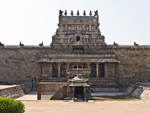 "+
"",
silentvalleybengali : "সাইলেন্ট ভ্যালিঃ-সাইলেন্ট ভ্যালি জাতীয় উদ্যান নীলগিরি বায়োস্ফিয়ারের একটা অংশ যা তামিলনাডু, কেরল এবং কর্ণাটক জুড়ে বিস্তৃত। সাইলেন্ট ভ্যালির উত্তরপূর্ব দিকে আট্টাপাডি রিজার্ভ ফরেস্টের একটা অংশ রয়েছে তামিলনাডুতে। যদি উত্তর দিকে অগ্রসর হওয়া যায় তবে, উপত্যকার বনভূমির কোর এরিয়ার পরে রয়েছে অমরামবালাম অভয়ারণ্য যা তামিলনাডু অব্দি বিস্তৃত ও আরও এগিয়ে, একদিকে মুডুমালাই টাইগার রিজার্ভ এবং অন্যদিকে উটির মুকুরঠি জাতীয় উদ্যানের সাথে মিশেছে। সাইলেন্ট ভ্যালির মূল প্রবেশদ্বার কেরালার পালাক্কাড থেকে যা তামিলনাডু ও কেরালার বিভাজন রেখা। পালাক্কাডের উত্তরপূর্ব কোণে রয়েছে বিখ্যাত সাইলেন্ট ভ্যালি। সাইলেন্ট ভ্যালির আয়তন ২৩৭ বর্গকিলোমিটার এবং এটাকে পৃথিবীর প্রাচীনতম রেইনফরেস্ট বলা হয়। এটা সম্ভবত দেশের একমাত্র অঞ্চল, যেখানে অবিচ্ছিন্নভাবে অপরিবর্তনীয় পরিবেশের কমপক্ষে ৫০ কোটি বছরের ইতিহাস রয়েছে। কিংবদন্তি আর ইতিহাসে সজ্জিত, উপত্যকাতে নীলগিরি থর, লায়নটেল মাকাউ ও মালাবার গ্রে হর্নবিল, হোয়াইট বেলিড ট্রিপী ইত্যাদি পাখির দেখা পাওয়া যায়। মহাভারতের গল্প অনুসারে পাণ্ডবরা যখন শকুনির কাছে পাশা খেলায় হেরে যান এবং ১৪ বছরের জন্যে বনবাসে নির্বাসিত হ’ন, তখন তাঁরা নাকি এই বছরগুলি সাইলেন্ট ভ্যালিতে কাটিয়েছিলেন বলে সেখানকার মানুষের ধারণা। তবে আমরা সাইলেন্ট ভ্যালির স্বাদ নেবার জন্যে কোডাইকানাল থেকে বেরিজাম লেকের রাস্তায় খানিকটা গেছিলাম। কেরালায় ভ্যালির প্রায় ২২ কি.মি. ভেতরে কুন্তি নদীর ব্রিজ অব্দি যাবার অনুমতি দেয়, যে অভিজ্ঞতার কথা কেরলের পেজে পাওয়া যাবে। কোডাইকানালে দর্শনীয় স্থানের মধ্যে একটা বিস্ময়কর স্থান হলো সাইলেন্ট ভ্যালি ভিউ পয়েন্ট। বেরিজাম লেকের রাস্তায় এটা পিলার রকের কাছে অবস্থিত। প্রকৃতি প্রেমীদের এটা একটা অন্যতম জনপ্রিয় জায়গা যেখান থেকে এই উপত্যকা তার সম্মোহিত করা দৃশ্য উপস্থাপন করে। হালকা কুয়াশামাখা শান্ত পরিবেশ আর প্রকৃতির এলোমেলো তুলির টানে তৈরি হওয়া উচ্ছল সবুজের প্রলেপ, বিভিন্ন রকমের পাখি ও জন্তু-জানোয়ার, উপত্যকার মনোমুগ্ধকর দৃশ্যাবলীতে যোগ করে এক নতুন মাত্রা, যা প্রত্যেক দর্শনার্থীকে অবাক করে দেয়। সাইলেন্ট ভ্যালি তার অবগুণ্ঠন উন্মোচিত করে ঊষাকালে ও সায়াহ্নে। যদি সেই সময় যাওয়া যায় তবে পাওয়া যাবে তার অভিভূত করা এক কুমারী রূপ। অসংগঠিত বিরামচিহ্নের মতো স্থানে স্থানে গাছের ফাঁক দিয়ে হালকা কুয়াশা মেখে থাকা এক শাড়ির আবরণ, নীল আকাশে সাদা মেঘের নির্মল হাসি আর পৃথিবীর একচ্ছত্র অধিপতির আগমন বা প্রস্থানে তৈরি হওয়া বর্ণময় নৈসর্গিক শোভা মনের মণিকোঠায় চিরবিরাজমান হয়ে থাকবে তা একপ্রকার নিশ্চিত। "+
"Read More..."+
"
"+
"",
silentvalleybengali : "সাইলেন্ট ভ্যালিঃ-সাইলেন্ট ভ্যালি জাতীয় উদ্যান নীলগিরি বায়োস্ফিয়ারের একটা অংশ যা তামিলনাডু, কেরল এবং কর্ণাটক জুড়ে বিস্তৃত। সাইলেন্ট ভ্যালির উত্তরপূর্ব দিকে আট্টাপাডি রিজার্ভ ফরেস্টের একটা অংশ রয়েছে তামিলনাডুতে। যদি উত্তর দিকে অগ্রসর হওয়া যায় তবে, উপত্যকার বনভূমির কোর এরিয়ার পরে রয়েছে অমরামবালাম অভয়ারণ্য যা তামিলনাডু অব্দি বিস্তৃত ও আরও এগিয়ে, একদিকে মুডুমালাই টাইগার রিজার্ভ এবং অন্যদিকে উটির মুকুরঠি জাতীয় উদ্যানের সাথে মিশেছে। সাইলেন্ট ভ্যালির মূল প্রবেশদ্বার কেরালার পালাক্কাড থেকে যা তামিলনাডু ও কেরালার বিভাজন রেখা। পালাক্কাডের উত্তরপূর্ব কোণে রয়েছে বিখ্যাত সাইলেন্ট ভ্যালি। সাইলেন্ট ভ্যালির আয়তন ২৩৭ বর্গকিলোমিটার এবং এটাকে পৃথিবীর প্রাচীনতম রেইনফরেস্ট বলা হয়। এটা সম্ভবত দেশের একমাত্র অঞ্চল, যেখানে অবিচ্ছিন্নভাবে অপরিবর্তনীয় পরিবেশের কমপক্ষে ৫০ কোটি বছরের ইতিহাস রয়েছে। কিংবদন্তি আর ইতিহাসে সজ্জিত, উপত্যকাতে নীলগিরি থর, লায়নটেল মাকাউ ও মালাবার গ্রে হর্নবিল, হোয়াইট বেলিড ট্রিপী ইত্যাদি পাখির দেখা পাওয়া যায়। মহাভারতের গল্প অনুসারে পাণ্ডবরা যখন শকুনির কাছে পাশা খেলায় হেরে যান এবং ১৪ বছরের জন্যে বনবাসে নির্বাসিত হ’ন, তখন তাঁরা নাকি এই বছরগুলি সাইলেন্ট ভ্যালিতে কাটিয়েছিলেন বলে সেখানকার মানুষের ধারণা। তবে আমরা সাইলেন্ট ভ্যালির স্বাদ নেবার জন্যে কোডাইকানাল থেকে বেরিজাম লেকের রাস্তায় খানিকটা গেছিলাম। কেরালায় ভ্যালির প্রায় ২২ কি.মি. ভেতরে কুন্তি নদীর ব্রিজ অব্দি যাবার অনুমতি দেয়, যে অভিজ্ঞতার কথা কেরলের পেজে পাওয়া যাবে। কোডাইকানালে দর্শনীয় স্থানের মধ্যে একটা বিস্ময়কর স্থান হলো সাইলেন্ট ভ্যালি ভিউ পয়েন্ট। বেরিজাম লেকের রাস্তায় এটা পিলার রকের কাছে অবস্থিত। প্রকৃতি প্রেমীদের এটা একটা অন্যতম জনপ্রিয় জায়গা যেখান থেকে এই উপত্যকা তার সম্মোহিত করা দৃশ্য উপস্থাপন করে। হালকা কুয়াশামাখা শান্ত পরিবেশ আর প্রকৃতির এলোমেলো তুলির টানে তৈরি হওয়া উচ্ছল সবুজের প্রলেপ, বিভিন্ন রকমের পাখি ও জন্তু-জানোয়ার, উপত্যকার মনোমুগ্ধকর দৃশ্যাবলীতে যোগ করে এক নতুন মাত্রা, যা প্রত্যেক দর্শনার্থীকে অবাক করে দেয়। সাইলেন্ট ভ্যালি তার অবগুণ্ঠন উন্মোচিত করে ঊষাকালে ও সায়াহ্নে। যদি সেই সময় যাওয়া যায় তবে পাওয়া যাবে তার অভিভূত করা এক কুমারী রূপ। অসংগঠিত বিরামচিহ্নের মতো স্থানে স্থানে গাছের ফাঁক দিয়ে হালকা কুয়াশা মেখে থাকা এক শাড়ির আবরণ, নীল আকাশে সাদা মেঘের নির্মল হাসি আর পৃথিবীর একচ্ছত্র অধিপতির আগমন বা প্রস্থানে তৈরি হওয়া বর্ণময় নৈসর্গিক শোভা মনের মণিকোঠায় চিরবিরাজমান হয়ে থাকবে তা একপ্রকার নিশ্চিত। "+
"Read More..."+
" "+
"
"+
" "+
"
"+
" "+
"
"+
" "+
"
"+
" "+
"
"+
" "+
"
"+
" "+
"
"+
" "+
"",
paikarabengali : "পাইকার হ্রদঃ-ভারতের অন্যতম জনপ্রিয় টুরিস্ট স্পট, তামিলনাড়ুর নীলগিরি জেলার উটি থেকে প্রায় ২৫ কিলোমিটার দূরে পাইকার হ্রদ অবস্থিত। একই নামে রয়েছে সুন্দর নদী সহ পাইকার গ্রাম, একটা বাঁধ ও একটা বিদ্যুৎ কেন্দ্র। বাঁধ নির্মাণের কারণে, ব্যাকওয়াটারগুলোর জল এক জায়গায় মিশে এই বিশাল হ্রদ তৈরি হয়েছে, যা এখন পাইকার হ্রদ হিসাবে পরিচিত। বর্তমানে হ্রদটা একটি গুরুত্বপূর্ণ পর্যটক আকর্ষণে পরিণত হয়েছে, যেখানে প্রায় সারা বছরই বিপুল সংখ্যক মানুষ ভ্রমণ করতে আসেন। প্রকৃতিপ্রেমী, ফটোগ্রাফার, নব্য বিবাহিত দম্পতি, অ্যাডভেঞ্চার প্রিয় যুবক যুবতী বা ভ্রমণ করতে যাওয়া যে কোনও ব্যক্তির কাছে, পারিপার্শ্বিকতা এবং স্বাচ্ছন্দ্য থেকে শুরু করে প্রাকৃতিক সৌন্দর্য ও রোমান্সের ব্যাপারে যা কিছু জিজ্ঞাসা করা যাক না কেন, পাইকারায় তার সবই আছে। হ্রদটা দেখার সেরা সময় অবশ্যই বর্ষাকাল, তবু অন্য সময়ও এর আকর্ষণ বিন্দুমাত্র কমে না। পাইকার এই জেলার বৃহত্তম নদী এবং এটা আদিবাসী সম্প্রদায় টোডাদের কাছে অত্যন্ত শ্রদ্ধাভাজন ও পবিত্র। নদীটা মুকুরথি পাহাড় থেকে উৎপন্ন হয়ে, ধারাবাহিক ভাবে একের পর এক অসাধারণ দৃষ্টিনন্দন জলপ্রপাতের সৃষ্টি করে, নৃত্যরত রমণীর অঙ্গবিন্যাসের মতো পাহাড়ি অঞ্চল পেরিয়ে মালভূমির প্রান্তে নেমে এসে, জন্ম দেয় পাইকার হ্রদের। শেষ দুটো জলপ্রপাত পাইকারা জলপ্রপাত হিসেবে পরিচিত এবং ৫৫ মিটার ও ৬১ মিটার উচ্চতা থেকে থেকে বাধাহীনভাবে পড়ে তৈরি করেছে এক দৃষ্টিনন্দন পরিপ্রেক্ষিত। জলপ্রপাতগুলো বিস্ময়কর হ্রদ থেকে থেকে মাত্র 2 কিলোমিটার দূরে অবস্থিত। পাইকারা, উটি লেকের চেয়ে যথেষ্ট বড়, ও এটা উটির পর্যটন হটস্পটের এক নতুন বিকল্প। পাইকার হ্রদের আশেপাশের অঞ্চলের নাম শোলা বন যা শোলা গাছ দ্বারা পরিবেষ্টিত। লেকের উত্তেজনাপূর্ণ ভ্রমণ উপভোগ করতে এখানে পাওয়া যাবে স্পিডবোট এবং মোটরবোট। সুস্বাদু খাবারের স্বাদ নেবার জন্যে, সুন্দর প্রাকৃতিক পরিবেশে তৈরি হয়েছে রেস্তোরাঁ। আর শুধু শুয়ে বসে আনন্দ উপভোগ করার জন্যে রয়েছে আরামদায়ক রেস্টহাউস। এ সবই চলে সরকারি ব্যবস্থাপনায়। লেকের চারপাশে ঘন সবুজ জঙ্গলের পটভূমিতে নীল জলের এই হ্রদ এক মনমোহিনী পরিবেশ তৈরি করে যা সত্যিই শুধুমাত্র নৌকা চড়া ছাড়াও অন্য এক আনন্দ দেয়। একা, বন্ধুবান্ধব বা পরিবারের সঙ্গে একদিন আনন্দ করার এক সুন্দর জায়গা হচ্ছে পাইকারা লেক। "+
"Read More..."+
"
"+
"",
paikarabengali : "পাইকার হ্রদঃ-ভারতের অন্যতম জনপ্রিয় টুরিস্ট স্পট, তামিলনাড়ুর নীলগিরি জেলার উটি থেকে প্রায় ২৫ কিলোমিটার দূরে পাইকার হ্রদ অবস্থিত। একই নামে রয়েছে সুন্দর নদী সহ পাইকার গ্রাম, একটা বাঁধ ও একটা বিদ্যুৎ কেন্দ্র। বাঁধ নির্মাণের কারণে, ব্যাকওয়াটারগুলোর জল এক জায়গায় মিশে এই বিশাল হ্রদ তৈরি হয়েছে, যা এখন পাইকার হ্রদ হিসাবে পরিচিত। বর্তমানে হ্রদটা একটি গুরুত্বপূর্ণ পর্যটক আকর্ষণে পরিণত হয়েছে, যেখানে প্রায় সারা বছরই বিপুল সংখ্যক মানুষ ভ্রমণ করতে আসেন। প্রকৃতিপ্রেমী, ফটোগ্রাফার, নব্য বিবাহিত দম্পতি, অ্যাডভেঞ্চার প্রিয় যুবক যুবতী বা ভ্রমণ করতে যাওয়া যে কোনও ব্যক্তির কাছে, পারিপার্শ্বিকতা এবং স্বাচ্ছন্দ্য থেকে শুরু করে প্রাকৃতিক সৌন্দর্য ও রোমান্সের ব্যাপারে যা কিছু জিজ্ঞাসা করা যাক না কেন, পাইকারায় তার সবই আছে। হ্রদটা দেখার সেরা সময় অবশ্যই বর্ষাকাল, তবু অন্য সময়ও এর আকর্ষণ বিন্দুমাত্র কমে না। পাইকার এই জেলার বৃহত্তম নদী এবং এটা আদিবাসী সম্প্রদায় টোডাদের কাছে অত্যন্ত শ্রদ্ধাভাজন ও পবিত্র। নদীটা মুকুরথি পাহাড় থেকে উৎপন্ন হয়ে, ধারাবাহিক ভাবে একের পর এক অসাধারণ দৃষ্টিনন্দন জলপ্রপাতের সৃষ্টি করে, নৃত্যরত রমণীর অঙ্গবিন্যাসের মতো পাহাড়ি অঞ্চল পেরিয়ে মালভূমির প্রান্তে নেমে এসে, জন্ম দেয় পাইকার হ্রদের। শেষ দুটো জলপ্রপাত পাইকারা জলপ্রপাত হিসেবে পরিচিত এবং ৫৫ মিটার ও ৬১ মিটার উচ্চতা থেকে থেকে বাধাহীনভাবে পড়ে তৈরি করেছে এক দৃষ্টিনন্দন পরিপ্রেক্ষিত। জলপ্রপাতগুলো বিস্ময়কর হ্রদ থেকে থেকে মাত্র 2 কিলোমিটার দূরে অবস্থিত। পাইকারা, উটি লেকের চেয়ে যথেষ্ট বড়, ও এটা উটির পর্যটন হটস্পটের এক নতুন বিকল্প। পাইকার হ্রদের আশেপাশের অঞ্চলের নাম শোলা বন যা শোলা গাছ দ্বারা পরিবেষ্টিত। লেকের উত্তেজনাপূর্ণ ভ্রমণ উপভোগ করতে এখানে পাওয়া যাবে স্পিডবোট এবং মোটরবোট। সুস্বাদু খাবারের স্বাদ নেবার জন্যে, সুন্দর প্রাকৃতিক পরিবেশে তৈরি হয়েছে রেস্তোরাঁ। আর শুধু শুয়ে বসে আনন্দ উপভোগ করার জন্যে রয়েছে আরামদায়ক রেস্টহাউস। এ সবই চলে সরকারি ব্যবস্থাপনায়। লেকের চারপাশে ঘন সবুজ জঙ্গলের পটভূমিতে নীল জলের এই হ্রদ এক মনমোহিনী পরিবেশ তৈরি করে যা সত্যিই শুধুমাত্র নৌকা চড়া ছাড়াও অন্য এক আনন্দ দেয়। একা, বন্ধুবান্ধব বা পরিবারের সঙ্গে একদিন আনন্দ করার এক সুন্দর জায়গা হচ্ছে পাইকারা লেক। "+
"Read More..."+
" "+
"
"+
" "+
"
"+
" "+
"
"+
" "+
"
"+
" "+
"
"+
" "+
"
"+
" "+
"
"+
" "+
"",
headingbengali : "তামিলনাডু",
headingenglish : "TAMILNADU",
};
"+
"",
headingbengali : "তামিলনাডু",
headingenglish : "TAMILNADU",
};