var Sikkimplaces =
{
menusystembengali :
" "+
"এই পাতার জায়গাসমূহঃ-"+
"মেনু দেখতে ক্লিক করুন"+
" •সিল্ক-রুট"+
" •রোলেপ "+
" •নাথাং-ভ্যালি"+
" •জুলুক"+
" •মাংখিম "+
" •ভার্সে"+
" •রিবদি"+
" •ওখড়ে "+
" •গুরদোংমার-লেক"+
" •ইউমথাং-ভ্যালি",
menusystemenglish :
" "+
"Places in This Page:-"+
"Click To See Menu"+
" •Silk-Route"+
" •Rolep "+
" •Nathang-Valley"+
" •Zuluk"+
" •Mankhim "+
" •Versay"+
" •Ribdi"+
" •Okhray "+
" •Gurdongmar-Lake"+
" •Yumthang-Valley",
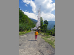
sikkimsilkroutebengali : "সিকিম সিল্ক রুটঃ-সিকিম সিল্ক রুট বা পুরানো সিল্ক রুট, তিব্বত ও ভারতের মধ্যে ব্যবসায়িক যোগাযোগের একটা রাস্তা, যা তিব্বতের লাসা থেকে চুম্বী ভ্যালি পেরিয়ে নাথুলা, জীপলা হয়ে তাম্রলিপ্ত বা তমলুকের সমুদ্র বন্দরে প্রবেশ করেছে। এখান থেকে সামুদ্রিক পথে ব্যবসা চলত দূরপ্রাচ্যে (চীন, জাপান, শ্রীলঙ্কা, বালি, জাভা ও পূর্ব এশিয়ার বিভিন্ন দেশে)। এটা মনে করা হয় যে এই সিল্ক রুট আবিষ্কার হয় প্রথম শতাব্দীতে (কেউ কেউ চতুর্থ শতাব্দী বলে থাকেন)। বাণিজ্য পণ্যের মধ্যে সিল্ক, চিনি, তুলো, চা, ঘোড়া ও বিভিন্ন রকমের ধনরত্ন উল্লেখযোগ্য। এই রাস্তা শীতকালে চলার অযোগ্য হয়ে যায় ও গ্রীষ্মকালে আবার চালু হয়। অনেকে এই রুটকে দক্ষিণ-পশ্চিম সিল্ক রুটও বলে থাকেন যা চীনের ইউনান প্রদেশ থেকে তিব্বত ও পরিশেষে ভারতবর্ষে এসে শেষ হয়। এই রুটে যে শুধু পণ্য বাণিজ্য হতো তাই নয় এখান দিয়েই এশিয়া, ইউরোপ ও আফ্রিকার সাথে বিভিন্ন চিন্তা, ভাবনা, শিল্পকলা, বৈজ্ঞানিক গবেষণা ও অন্যান্য সাংস্কৃতিক মননের আদান প্রদান হতো। আরব দেশের মানুষজন ভারত ও চীন থেকে ঔষধ ও অঙ্কের ধারণা নিয়ে বীজগণিতের মতো ফলিত গণিত আবিষ্কার করেন ও পরবর্তীকালে ইউরোপে তা গৃহীত হয়। এসবের জন্যে এই রুটকে বলা হয় পৃথিবীর প্রথম তথ্য আদান প্রদানের সড়কপথ ও সাংস্কৃতিক বিনিময় কেন্দ্র। এই রুটের বিভিন্ন জায়গার নিখুঁত তথ্য পরিবেশন করেন ফ্রান্সিস এডওয়ার্ড ইয়ংহাসব্যাণ্ড নামে একজন ব্রিটিশ মিলিটারি অফিসার ও অনুসন্ধানকারী। তিনি তাঁর বাহিনী নিয়ে লাসা দখল ও লুণ্ঠনের সময় এই রুট, উত্তর সিকিমের বিভিন্ন অঞ্চল ও তিব্বতের বিভিন্ন ভূখণ্ডের ব্যাপক নিরীক্ষণ করেন যা তাঁর লেখা “India & Tibet” বইটাতে পাওয়া যায়। অত্যন্ত গুরুত্বপূর্ণ এই সড়কপথ বন্ধ হয়ে যায় ১৯৬২ সালে ভারত-চীন যুদ্ধের পর। "+
"Read More..."+ "
"+
"শব্দঃ প্রতিবেদনঃ "+
""+ "ভিডিও"+
"স্লাইডশোর জন্যে নীচের ছবিতে ক্লিক করুন "+
"
"+ "পেজ মেনুতে যান",
sikkimsilkrouteenglish : "Sikkim Silk Route:-The Sikkim Silk Route, or the old Silk Route, is a trade link between Tibet and India, which crosses the Chumbi Valley from Lhasa in Tibet to Nathula, Jipla, Tamralipta or the seaport of Tamluk. From here the sea trade took place in the Far East (China, Japan, Sri Lanka, Bali, Java and various countries in East Asia). It is believed that the Silk Route was discovered in the first century (some call it in the fourth century). Among the trade goods are silk, sugar, cotton, tea, horse and various kinds of gems. This road becomes impassable in winter and reopens in summer. Many call this route the Southwest Silk Route, which runs from China's Yunnan Province to Tibet and finally to India. This route not only traded goods but also exchanged ideas, thoughts, art, scientific research and other cultural philosophies with Asia, Europe and Africa. The people of the Arab world invented applied algebra-like mathematics taking the concept of medicine and arithmetic from India and China and later it was adopted in Europe. For all this, this route is called the world's first information exchange road and cultural exchange center. Francis Edward Younghasband, a British military officer and investigator, provided accurate information on various locations along the route. During his occupation and plunder of Lhasa with his troops, he made extensive observations of this route, various parts of North Sikkim and various parts of Tibet, which he described in his book named ‘India & Tibet’. This important road was closed after India China war in 1962. "+
"Read More..."+ "
"+
"Sound Stream: "+
""+ "Video"+
"Click any Picture for Slide Show "+
"
"+ "Go To Page Menu",
photosikkimsilkroute :
""+
" "+
" "+
" "+
" "+
" "+
" "+
" "+
""+
"",
rolepbengali : "রোলেপঃ-সিকিম সিল্ক রুটে যাবার অনুমতিপত্র যেখান থেকে নিতে হয় সেই রঙ্গোলীর কাছ দিয়ে একটা রাস্তা চলে গেছে পূর্ব সিকিমের এক অপূর্ব সুন্দর জায়গা, রোলেপে। রোলেপকে বলা হয় পাখির নতুন স্বর্গরাজ্য ও শান্তির জায়গা। গ্রামের পাশ দিয়ে নীল ফেনায়িত জলের রাশি নিয়ে কল কল ছল ছল শব্দে বয়ে চলেছে সোকে খোলা নদী। আর কাছেই রয়েছে চোখ জোড়ানো বুদ্ধা ফলস। তার ধারা আবার জলের অঞ্জলি দিচ্ছে পুণ্যতোয়া সোকে খোলা নদীতে। ঘন জঙ্গল থাকার কারণে এখানে প্রচুর পাখি প্রায় সারা বছরই পাওয়া যায়। সিল্ক রুটে অবস্থিত নাথাং ভ্যালির সমস্ত জলধারা বয়ে চলেছে এই সোকে খোলা নদী দিয়েই, কারণ এই গ্রামের ঠিক ওপরেই রয়েছে নাথাং ভ্যালি। কাছেই রয়েছে তারের একটা ঝুলন্ত ব্রিজ যেখান থেকে সোকে খোলা নদীকে খুব ভাল ভাবে পর্যবেক্ষণ করা যায়। প্রকৃতির সাথে থাকার সঙ্গে সঙ্গে একটু স্বাদ পরিবর্তন করে দেখে নেওয়া যায় কাছেই থাকা ডেকলিং মনাস্ট্রি। সকাল-সন্ধ্যায় ওঁ মণি-পদ্মে হুম শব্দ সবার মধ্যে আধ্যাত্মিক অনুভব সৃষ্টি করতে না পারলেও, ভাল লাগবে তা একপ্রকার নিশ্চিত। অলস-ভাবে দিন কাটানোর এক অনন্য ঠিকানা হচ্ছে রোলেপ। "+
"Read More..."+ "
"+
"শব্দঃ প্রতিবেদনঃ "+
""+ "ভিডিও"+
"স্লাইডশোর জন্যে নীচের ছবিতে ক্লিক করুন "+
"
"+ "পেজ মেনুতে যান",
rolepenglish : "Rolep:-A road has passed through Rangoli to Rolem, a beautiful place in East Sikkim, the place where you have to get permission to go on the Sikkim Silk Route,. Rolep is called the new bird's paradise and place of peace. The open river Soke is flowing with lisp of blue foamy water by the side of the village. And nearby is the eye-catching Buddha Falls. Its stream is again offering water in the open river of sacred Soke. Due to the dense jungle, a lot of birds are found here almost all the year round. Located on the Silk Route, all the waters of the Nathang Valley flow through this open river, as the Nathang Valley is just above the village. Neighboring is a cable-stayed suspension bridge overlooking the Soke River. The nearby Decling Monastery can be seen by changing the taste a little while staying with nature. Although the word Om Manipadme Om in the morning and evening may not create a spiritual feeling to everyone, it is sure that everybody will like it. Rolep is a unique place to spend your day lazily. "+
"Read More..."+ "
"+
"Sound Stream: "+
""+ "Video"+
"Click any Picture for Slide Show "+
"
"+ "Go To Page Menu",
photorolep :
""+
" "+
" "+
" "+
" "+
" "+
" "+
" "+
""+
"",
nathangvalleybengali : "নাথাং ভ্যালিঃ-নাথাং উপত্যকা সমুদ্রতল থেকে প্রায় ১৩,৫০০ ফুট উচ্চতায় অবস্থিত এক অজানা স্বর্গ। অতিরিক্ত তুষারপাতের জন্যে বছরে চার পাঁচ মাস এই উপত্যকায় প্রবেশ করা দুরূহ হয়ে যায় ও সেখানকার মানুষজন নীচে নেমে আসেন। থেকে যান শুধু ভারতীয় সেনারা। এখানকার মানুষজন বেশিরভাগ তিব্বতি ও পুরো সিল্ক রুটের সবাই শেভ তিব্বতের সমর্থক। সাধারণভাবে এনাদের পেশা ইয়াক চড়ানো। এখানকার ছোট ছোট জলপ্রবাহ একটু একটু করে মিশে তৈরি হয়েছে ঠিক নাথাং ভ্যালির নীচে অবস্থিত রোলেপ গ্রামের মধ্যে দিয়ে প্রবাহিত হওয়া সোকে খোলা নদী। পাহাড়ের মাথায় পতপত করে উড়তে থাকা বিচিত্র রঙের বৌদ্ধ প্রার্থনা পতাকা নাথাঙের সৌন্দর্যে যোগ করেছে আর এক মুকুট। আবহাওয়া চক্রের এক এক সময়ে নাথাঙের সৌন্দর্য এক এক রকম। বর্ষাকালে বহু বর্ণের ফুলের সমারোহে নাথাং সেজে ওঠে রাণীর সাজে। শরৎকালে শুকনো ঘাসের রঙ তৈরি করে এক স্বর্ণালী আবহমণ্ডল। আর শীতকালে নাথাং ঘুমিয়ে পড়ে প্রায় পাঁচ-ছ ফুট বরফের নীচে। শীতের প্রারম্ভে বহু পরিযায়ী পাখি এখানে আসে। সেই সময়ে অনেক পক্ষী বিশারদ ও ফটোগ্রাফারদের দেখা মেলে। এখান থেকে বিখ্যাত সূর্যোদয় পয়েন্ট লুংথাং প্রায় হাত ছোঁয়া দূরত্বে। এই নাথাং ভ্যালিতেই রয়েছে পর্যটকদের জন্য অজস্র আকর্ষণ যা অনুভব করতে গেলে এখানে থাকতে হবে। থাকা কষ্টকর হলেও বর্তমানে হোমস্টেগুলোতে ঘর গরম করার যন্ত্র, গরম জলের ব্যবস্থা ও খাওয়া-দাওয়ার সুবন্দোবস্ত রয়েছে। বেড়ানোর মধ্যে রয়েছে পুরানো বাবা হরভজন সিং মন্দির, ঈগলস নেস্ট বাঙ্কার, কুপুপ লেক (এই লেককে দেখতে হাতির মতো তাই একে এলিফ্যান্ট লেকও বলে) আর তুষারাবৃত ছোট ছোট নাম না জানা পর্বতশৃঙ্গ। প্রাকৃতিক দৃশ্যাবলী ও এই অঞ্চলের দুর্গমতার জন্যে নাথাং ভ্যালিকে বলা হয় পূর্ব সিকিমের স্বর্গ। "+
"Read More..."+ "
"+
"শব্দঃ প্রতিবেদনঃ "+
""+ "ভিডিও"+
"স্লাইডশোর জন্যে নীচের ছবিতে ক্লিক করুন "+
"
"+ "পেজ মেনুতে যান",
nathangvalleyenglish : "Nathang Valley:- Nathang Valley is an unknown paradise located at an altitude of about 13,500 feet above sea level. Excessive snowfall makes it difficult to enter the valley for four to five months of the year, and people flock down. Only Indian troops remain. The people here are mostly Tibetans and everyone on the entire Silk Route is a supporter of Save Tibet. In general, their profession is to graze yaks. The small streams are gradually merged to form the Soke River, which flows through the village of Rolep, just below the Nathang Valley. The colorful Buddhist prayer flag fluttering on the top of the hill adds another crown to Nathang's beauty. At different weather cycle, Nathang's beauty is of a different kind. In the rainy season, Nathang is dressed as a queen in a multi-colored flower ceremony. A golden atmosphere creates the color of dry grass in autumn. And in the winter Nathang fell asleep about five or six feet under the snow. Many migratory birds come here in early winter. Many ornithologists and photographers met at that time. The famous sunrise point Lungthang is almost a handful distance away from here. This Nathang Valley has a lot of tourist attractions to experience. Although it is difficult to stay, homestays now have heating equipment, hot water and food and drink. Excursions include the old Baba Harbhajan Singh Temple, Eagles Nest Bunker, Kupup Lake (this lake looks like an elephant hence it is also called Elephant Lake) and small snow-capped mountain peaks. Nathang Valley is said to be the paradise of East Sikkim due to its scenic beauty and inaccessibility to the region. "+
"Read More..."+ "
"+
"Sound Stream: "+
""+ "Video"+
"Click any Picture for Slide Show "+
"
"+ "Go To Page Menu",
photonathangvalley :
""+
" "+
" "+
" "+
" "+
" "+
" "+
" "+
""+
"",
julukbengali : "জুলুকঃ-খাঁজকাটা পাহাড়ের বন্ধুর প্রস্তরময় পথের মাঝে ১০,০০০ফুট উচ্চতায় অবস্থিত জুলুক পূর্ব সিকিম সিল্ক রুটের অন্যতম জনপ্রিয় জনপদ। পাহাড়ে পথের বেষ্টনী দেওয়া রাস্তা শুরু হয়েছে জুলুক থেকেই। আগে তিব্বত থেকে আসা ব্যবসায়ীরা এখানে বিশ্রাম নিতেন ফলে জুলুক অনেক পুরানো গ্রাম হিসাবে সবার কাছে পরিচিত। সীমান্তবর্তী এলাকা ও মিলিটারি স্ট্র্যাটিজিক পয়েন্ট হওয়ার ফলে এখানকার মিলিটারি গুরুত্ব অনেক, তাই এখানে মিলিটারি ক্যাম্প আছে এবং সেখান থেকেই গ্রামে বিদ্যুৎ সরবরাহ করা হয়। এখান থেকে কাঞ্চনজঙ্ঘার সূর্যোদয়ের অপার সৌন্দর্য উপভোগ করা যায়। তবে কিছুটা ওপরে থাম্বি ভিউ পয়েন্ট থেকে পুরো কাঞ্চনজঙ্ঘাকে আরও ভালো ভাবে দেখা যায়। জুলুক থেকে অনেক পরিদর্শকই পদমচেন, লুংথাং, নাথাং, টুকলা ভ্যালি,, পুরানো বাবা মন্দির হয়ে কুপুপ লেক গিয়ে আবার ফিরে আসেন। "+
"Read More..."+ "
"+
"শব্দঃ প্রতিবেদনঃ "+
""+ "ভিডিও"+
"স্লাইডশোর জন্যে নীচের ছবিতে ক্লিক করুন "+
"
"+ "পেজ মেনুতে যান",
julukenglish : "Zuluk:-Located at a height of 10,000 feet in the middle of the shaggier rocky path of the notched hills, Zuluk is one of the most popular towns on the Silk Route in East Sikkim. The road that encircles the mountains has started from Zuluk. Traders from Tibet used to rest here, so Zuluk is known as a very old village. Being a border area and a military strategic point, it has a lot of military importance, so there are military camps here and electricity is supplied to the village from there. From here one can enjoy the immense beauty of Kanchenjunga sunrise. However, the whole of Kanchenjunga can be seen better from the Thumbi view point a little above. Many visitors from Zuluk return to Padamchen, Lungthang, Nathang, Tukla Valley, Kupup Lake through the old Baba Temple. "+
"Read More..."+ "
"+
"Sound Stream: "+
""+ "Video"+
"Click any Picture for Slide Show "+
"
"+ "Go To Page Menu",
photojuluk :
""+
" "+
" "+
" "+
" "+
" "+
" "+
" "+
""+
"",
mankhimbengali : "মাংখিমঃ-দালাপচাঁদ গ্রামের ওপরে প্রকৃতির এক নাটকীয় রঙ্গমঞ্চে অবস্থিত, অতি ছোট্ট একটা জনপদের নাম মাংখিম। গ্রামটা মাংখিম ভিউ-পয়েন্টের ঠিক নীচেই অবস্থিত যেখান থেকে দৃশ্যমান হয় অত্যন্ত জনপ্রিয় ভ্রমণ-স্থান আরিটার। মাংখিম থেকে এখনও অনুভব করা যায় প্রকৃতির সেই অনাবৃত আদিম রূপ যা মানুষের মনে সাময়িকভাবে হলেও এনে দেয় এক অনাবিল আনন্দ-স্রোত। গ্রামের নীচেই রয়েছে লামপোখরি লেক যার পান্না-সবুজ জল ও কাঞ্চনজঙ্ঘার চোখ ধাঁধানো সৌন্দর্যের স্ফুলিঙ্গ মানুষকে করে দেয় বাকরুদ্ধ। আর এই সৌন্দর্যকে পরিকীর্ণ করে আছে আরিটার মনাস্ট্রি ও পাহাড়ের মাথায় থাকা এক ছোট্ট শিব মন্দির। শহরের কোলাহল ও দৈনন্দিন প্রতিযোগিতামূলক জীবন থেকে এই শান্ত পরিবেশে কয়েকটা দিন থাকলে মানুষ পাবে নতুনভাবে বাঁচার ইন্ধন। ঘন জঙ্গলের মধ্যে পাখির ডাক শুনতে শুনতে কখন যে সন্ধ্যা গড়িয়ে যাবে তা টেরও পাওয়া যায় না। "+
"Read More..."+ "
"+
"শব্দঃ প্রতিবেদনঃ "+
""+ "ভিডিও"+
"স্লাইডশোর জন্যে নীচের ছবিতে ক্লিক করুন "+
"
"+ "পেজ মেনুতে যান",
mankhimenglish : "Mankhim:-Mankhim is a very small town situated on a dramatic stage of nature above the village of Dalapchand. The village is located just below Mankhim View Point, overlooking the very popular tourist destination of Aritar. From Mankhim one can still feel the unveiled primitive form of nature which, even if only temporarily, brings an inexhaustible stream of joy to the human mind. Below the village is Lampokhari Lake, whose emerald-green waters and the dazzling spark of Kanchenjunga make people speechless. And this beauty is surrounded by the Aritar Monastery and a small Shiva temple at the top of the hill. With a few days in this quiet environment, away from the noise and daily competitive life of the city, people will get new way of life to live. Unknowingly the evening will pass when you hear the call of birds in the dense forest. "+
"Read More..."+ "
"+
"Sound Stream: "+
""+ "Video"+
"Click any Picture for Slide Show "+
"
"+ "Go To Page Menu",
photomankhim :
""+
" "+
" "+
" "+
" "+
" "+
" "+
" "+
""+
"",
versaybengali : "ভার্সেঃ-ভার্সে সিকিমের একেবারে পশ্চিম সীমান্তে, প্রায় পশ্চিমবঙ্গ লাগোয় এক জায়গা, যা রডোডেনড্রন ফুলের জন্যে বিখ্যাত। এটা একটা বিশাল ১০৪ বর্গ কিমি রডোডেনড্রন স্যাঙ্কচুয়ারি, যা মার্চের মাঝামাঝি থেকে এপ্রিলের মাঝামাঝি পর্যন্ত, ফুলের মরসুমে, ভ্রমণার্থীদের আকর্ষণ করে। রক্ত লাল থেকে দুধ সাদা বিভিন্ন রঙের ৬০০ রকমের রডোডেনড্রন ফুলের সমারোহে পুরো বন জ্বলজ্বল করে। আবার এই অভয়ারণ্যেই রয়েছে বিরল উদ্ভিদজগত ও প্রাণীজগতের আবাস যার মধ্যে বিলুপ্তপ্রায় প্রাণী রেড পান্ডা উল্লেখযোগ্য। রয়েছে অর্কিডের বৈচিত্র্য আর বিভিন্ন রকমের পাখির ঠিকানা। ঠিক বিপরীতে রয়েছে কাঞ্চনজঙ্ঘা ম্যাসিফের সুউচ্চ পর্বতশৃঙ্গের হাতছানি। সূর্যোদয়ে রঙের খেলা দেখা সত্যিই একটি অবিস্মরণীয় অভিজ্ঞতা। ভার্সে রডোডেনড্রন অভয়ারণ্য সার্কিট ট্রেক টেথিসের হিমায়িত তরঙ্গের একটা অসাধারণ দৃশ্য দেখায়। ৩,৬০০ মিটার উচ্চতায় দাঁড়িয়ে ৮,০০০ মিটার উচ্চতার ঢেউ খেলানো স্তরগুলোয় পৃথিবীর সর্বোচ্চ পর্বতশৃঙ্গের চারটে একসাথে মিলিত হয়, যার মধ্যমণি পৃথিবীর দ্বিতীয় সর্বোচ্চ পর্বতশৃঙ্গ কাঞ্চনজঙ্ঘা। বাকিগুলো মাউন্ট এভারেস্ট, মাউন্ট লোৎসে এবং মাকালু। তবে এখান থেকে কাঞ্চনজঙ্ঘাকেই সবথেকে কাছে ও সুন্দর দেখায়। বাকিরা তুলনায় অনেক ছোট ও দূরে দেখা যায়।ভার্সে, সিঙ্গালীলা জাতীয় উদ্যানের অন্তর্গত, যার পশ্চিম প্রান্তে রয়েছে নেপাল সীমান্ত এবং দক্ষিণে পশ্চিমবঙ্গ রাজ্য। রামাম খোলা বা নদী, সিকিম ও পশ্চিমবঙ্গকে ভাগ করেছে। এখান থেকে অনেক সুন্দর সুন্দর ট্রেক করা যায় যা অ্যাডভেঞ্চার প্রেমীদের আকর্ষণ করে। মিনিট পনের হাঁটলেই পাওয়া যাবে ১০০ ডিগ্রি উন্মুক্ত এক ক্যানভাসে প্রকৃতির খেয়ালী তুলির টানে আঁকা সুউচ্চ পর্বতমালা কাঞ্চনজঙ্ঘার ছবি। পাঁচ কিমি দূরে রয়েছে প্রকৃতির অকৃপণ দানে তৈরি হওয়া নীল জলের লেক গুরাসতাল। নৈসর্গিক বৈচিত্রের মধ্যে আর একটু হেঁটে ফুটেধারা গেলে, চলে যাওয়া যাবে প্রাকৃতিক সৌন্দর্যের নাট্যমঞ্চের আরও দুই রমণীয়ার কাছে - সোরেং ও হি-বার্মোইক। আরও বেশি চাইলে, যেতে পারা যাবে দেওলিঙ্গা ধাপ, জড়িবুটি, থুলধাপ, কালিঝাড় ইত্যাদি হয়ে সিঙ্গালীলা পাস ও তারপর ফালুট, সান্দাকফু ইত্যাদি। তবে সিঙ্গালীলা ট্রেক মনের মধ্যে রেখাপাত করে যাবে তার প্রাকৃতিক সৌন্দর্যের জন্যে। কি নেই তাতে – ঝর্ণা, নদী, গহন অরণ্য, সবুজ গালচে পাতা ভ্যলি, সুউচ্চ পর্বতমালা, নীল আকাশে সাদা মেঘের আনাগোনা, পাখির ডাকে মুখরিত এলাকা, প্রকৃতির নিজের হাতে লেখা উপন্যাসে বিরামচিহ্নের মতো ছোট ছোট গ্রাম ও আরো অনেক কিছু যা আমার মতো নগন্য মানুষের পক্ষে বর্ণনা করা অসম্ভব। ভার্সেতে থাকার জন্যে নিজের টেন্ট ও খাবাররে সংস্থান নিজেকেই করতে হবে। আর তা নইলে একমাত্র থাকার জায়গা গুরাসকুঞ্জের ডরমিটরি। কিছু টেন্টও ভাড়া পাওয়া যায়। খুব ভিড় হয় ছুটির দিনে, তাই থাকার ব্যবস্থা আগে থেকে করা ভাল। তবে এখানে থাকার ব্যবস্থা অত্যন্ত সীমিত স্বাচ্ছন্দ্যের ভিত্তিতে। যেমন থাকার প্রাইভেট ঘর নেই, টয়লেট ইন্ডিয়ান, লাগাতার জলের যোগান নেই, রাত্রে মোমের আলোই ভরসা ইত্যাদি। বস্তুত, নাগরিক সভ্যতার যান্ত্রিক জীবনযাপন থেকে শত যোজন দূরে বেঁচে থাকার এই একমাত্র জায়গা, যেখানে স্বাচ্ছন্দ্য সীমিত হলেও বিস্তৃতি অসীম।যদি কেউ আগে থাকতে বুক করতে চান তবে যোগাযোগ করুনঃ- সামদিং শেরপা, মোবাইল +৯১ ৭৫৫১৮৭৮৯৪৫, ৯৪৭৫৯১৯৭১৪। হিলে থেকে শুরু হয় ভার্সে ট্রেকিং। হিলেতে থাকার জন্যে সামদিং শেরপার দুটো ঘর আছে। জনপ্রতি ও দিনপ্রতি ১,০০০ টাকা খাওয়া থাকা সমেত। ভার্সেতেও থাকা খাওয়ার খরচ একই মানে ১,০০০ টাকা জনপ্রতি ও দিনপ্রতি।যাওয়া আসাঃ-নিউ জলপাইগুড়ি থেকে সরাসরি হিলে ভাড়া নেবে প্রায় ৫০০০ টাকা। শেয়ার জিপে জোরথাং ৩০০ টাকা ও সেখান থেকে রিবদি ২৫০ টাকা। সেখান থেকে গাড়ি বুক করে হিলে ১,০০০ টাকা। অথবা জোরথাং থেকে শেয়ার জিপে ওখরে নেমে এক রাত কাটিয়ে পরের দিন হিলে যাওয়া যেতে পারে। ওখরে থেকে হিলের ভাড়া একপিঠে ১,০০০ টাকা। হিলে থেকে রিবদি ১,৫০০ টাকা, ওখরে ১,০০০ টাকা। এই এলাকায় যত হোমস্টে আছে সবের ভাড়াই ১,০০০ টাকা জনপ্রতি ও দিনপ্রতি। ওখরেতে যদি কোন হোমস্টেতে কেউ থাকে, তবে সেই হোমস্টের মালিকও ভার্সেতে থাকার ব্যবস্থা করে দেয়। "+
"Read More..."+ "
"+
"শব্দঃ প্রতিবেদনঃ "+
""+ "ভিডিও"+
"স্লাইডশোর জন্যে নীচের ছবিতে ক্লিক করুন "+
"
"+ "পেজ মেনুতে যান",
versayenglish : "Versay:-Versay is a place on the very western border of Sikkim, near West Bengal, which is famous for its rhododendron flowers. It is a huge 104 square km rhododendron sanctuary, which attracts tourists during the flowering season from mid-March to mid-April. The whole forest is ablaze with 600 varieties of rhododendron flowers of different colours from blood red to milk white. The sanctuary is home to rare flora and fauna, most notably the endangered Red Panda. It is an address to variety of orchids and birds. Opposite is the beckoning of the high mountains of Kanchenjunga Massif. Watching the drama of colours at sunrise is truly an unforgettable experience. The Versay Rhododendron Sanctuary Circuit Trek shows a spectacular view of the frozen waves of Tethys. Standing at an altitude of 3,600 meters, the four 8,000-meter-high mountain peaks of the world meet together in the liny layers, the central jem of which is Kanchenjunga, the second highest mountain in the world. The rest are Mount Everest, Mount Lhotse and Mount Makalu. But from here, Kanchenjunga looks the closest and most beautiful. Others are much smaller and farther away.Versay belongs to the Singalila National Park, which borders Nepal on the west and the state of West Bengal on the south. Ramam Khola or river, divided Sikkim and West Bengal. From here many beautiful treks can be done which attracts adventure lovers. Within a 15-minute walk one can find a picture of towering mountain Kanchenjunga, painted by the whimsical brushwork on a natural canvas with a 100-degree open canopy. Five kilometers away is Lake Guras Tal, a blue-water lake created by the generous gifts of nature. After a short walk through the natural diversity, you can head to the two more floozies of the dramatic stage of Natural Beauty - Soreng and Hi-Bermoic. If you want more, you can go to Deolinga Dhap, Jaributi, Thuldhap, Kalijhar up to Singalila Pass and then Phalut, Sandakfu etc. But the Singalila trek will linger in the mind for its natural beauty. What's not to like - fountains, rivers, deep forests, lush green valleys, towering mountains, white clouds in the blue sky, singing birds, small villages like punctuation marks in nature's own handwritten novels and much more which is impossible to describe for trivial people like me. To stay in Versay you have to provide your own tents and food. Otherwise, the only place to stay is the dormitory of Gurasakunj. Some tents are also available for rent. It is very crowded on holidays, so it is better to make arrangements in advance. However, accommodation here is based on very limited comfort. For example, there is no private house, toilet is Indian, there is no continuous water supply, candle light at night is the only hope. In fact, it is the only place that survives hundreds of miles away from the mechanical life of civilized society, where comfort is limited but the extent is infinite.If anyone wants to book in advance, Please contact:-Samding Sherpa, Mobile 91 85517945, 9465919614. Trekking starts from the Hillay. Samding Sherpa has two rooms to stay in the Hillay. Including food Rs.1000/- per person and per day. The cost of food in Versay is the same, which means Rs.1,000/- per person and per day.Getting there:-For going direct to Hillay, taxi from New Jalpaiguri will cost around Rs.5000/-. With Share Jeep Jorthang Rs.300/- and Ribdi Rs.250/-. From Ribdi, book a car for Rs.1000/- to Hillay. Or you can take a share jeep from Jorthang to Okhre and spend one night there and go to the Hillay the next day. From Okhre, the rent for the Hillay is Rs. 1,000/-. From Hillay to Ribdi Rs.1,500/-. The rent of all the homestays in this area is Rs.1000/- per person and per day. If anyone stays in a homestay at Okhray or Hillay, the owner of that homestay also arranges for you to stay in Versay. "+
"Read More..."+ "
"+
"Sound Stream: "+
""+ "Video"+
"Click any Picture for Slide Show "+
"
"+ "Go To Page Menu",
photoversay :
""+
" "+
" "+
" "+
" "+
" "+
" "+
" "+
""+
"",
okhraybengali : "ওখড়েঃ-মনোরম এবং মনোমুগ্ধকর ওখড়ে পশ্চিম সিকিমের ভার্সে রডোডেনড্রন স্যাঙ্কচুয়ারি কাছে অবস্থিত একটা ছোট অনামা গ্রাম। এই গ্রামের বেশিরভাগই শেরপা ও ভুটিয়া অধ্যুষিত ও তাদের মূল জীবিকা কৃষিকার্য। প্রাকৃতিক সৌন্দর্য ও শান্ত পরিবেশের জন্যে এই গ্রাম ভ্রমণার্থীদের কাছে বেশি পছন্দের। নিকটতম জনপদ রয়েছে প্রায় ২০ কিলোমিটার দূরে সোম্বেরিয়ায়। ওখড়ে বিখ্যাত হয়ে উঠেছে ভার্সে রডোডেনড্রন অভয়ারণ্যের প্রবেশদ্বার এবং সেই সঙ্গে চেওয়া ট্রেলসের মিলনস্থল যা দক্ষিণে দার্জিলিং, উত্তরে সিকিম এবং পশ্চিমে নেপালের দিকে নিয়ে যায়। প্রতি বছর মার্চের মাঝামাঝি থেকে এপ্রিলের মাঝামাঝি পর্যন্ত, অনেক প্রকৃতিপ্রেমী, অ্যাডভেঞ্চাচারিষ্ট এবং উদ্ভিদবিদরা মহিমান্বিত রডোডেনড্রনের গৌরব অনুভব করতে এই ছোট্ট গ্রামে আসেন ও আশেপাশের বনের লাল এবং গোলাপি রঙের প্রাণবন্ত ছায়ায় জীবনকে রাঙিয়ে নিয়ে যান। চতুর্দিকের বনফুল বিনম্রভাবে অভ্যাগতকে শুভেচ্ছা জানায়। পরিষ্কার আকাশ ও মনোরম তাপমাত্রা এই আবেদনে শান্তির এক নতুন মাত্রা যোগ করে।প্রকৃতি সিকিম রাজ্যটার প্রতিটা বাঁক বেশ সুন্দর করে সাজিয়ে রেখেছে। গুটিকতক ছড়ানো ছিটনো কাঠের বাড়ি নিয়ে তৈরি এই ছোট্ট গ্রামটাও এক অনন্য টুরিস্ট স্পট। এখন কিছু কংক্রিটের বাসস্থান গড়ে উঠলেও তা গ্রামের সৌন্দর্যে এখনও শহুরে প্রভাব ফেলতে পারেনি। এখনও নিজের মত করে দিব্যি সতেজ ও সুন্দর রয়েছে ওখড়ে গ্রামটা। এখানকার বেশিরভাগ হোমস্টেতে অকারণ বাহুল্য বা বিলাসিতার চিহ্নমাত্র নেই। তবে রয়েছে স্বাভাবিক জীবনযাপনের পরিচ্ছন্ন ব্যবস্থাপনা। আর যারা একটু ভোজন রসিক, তাঁরা খাঁটি সিকিমিজ খাবারের লোভেই শুধুমাত্র চলে যেতে পারেন। অসাধারণ এই গ্রামটায় মেঘ পাহাড়ের আলিঙ্গনের রঙিন ছবি দেখা, চুল এলোমেলো করা ঠাণ্ডা বাতাসে সোঁদা জংলী গন্ধ পরখ করা, পাখির গান শোনা, গ্রামের শিশুদের সঙ্গে খেলা করা (দু-একটা চকোলেট অবশ্যই দিতে হবে), আর আরও অনুভবী হলে পাহাড়ের সঙ্গে গল্প করা যেতে পারে। আর এসব কিছু করতে ইচ্ছে না করলে শুধু বসে বসেই সারাদিন কাটিয়ে দেওয়া যায়। আদিগন্ত সবুজ গালচে বেছানো নিরিবিলি এই গ্রামে ঘুম ভাঙায় হিমালয়ের অচিন পাখিরা। দু-তিন দিনের ছুটি পেলে বেড়িয়ে নেওয়া যায় এই মেঘ পাহাড়ের দেশ, সঙ্গে অবশ্যই থাকবে হিলে ও ভার্সে। একটু সময় থাকলে রিবদিটাও জুড়ে নেওয়া যায়। হেঁটে বা গাড়িতে চলে যাওয়া যেতে পারে ওখড়ে মঠে। ওখড়ের উগেন থংমিওংলিং মঠ ১৯০৫ সালে শেরপা বৌদ্ধ অনুগামীদের দ্বারা নির্মিত হয়েছিল। এটা ওখড়ে গ্রামের ওপরে একটা পাহাড়ে অবস্থিত এবং এখানে সারা বছর ধরে বিভিন্ন ধর্মীয় অনুষ্ঠান অনুষ্ঠিত হয়। ১৯৬৬ সালে ডুকপা লামা এই মঠের দায়িত্ব নেন ও একটা বৌদ্ধ স্কুল তৈরি করেন। ১৯৮৬ সালে এই মঠের দায়িত্ব, গ্যাংটকের দদ্রুবচেন রিংপনচেন মনাস্ট্রির কাছে হস্তান্তর করা হয়েছিল। এটা তিব্বতি বৌদ্ধধর্মের নাইংমাপা সম্প্রদায়কে অনুসরণ করে।ওখড়ের ঠিক উল্টো দিকের পাহাড়টাই দার্জিলিং। নির্জন ওখড়ের নিঝুম রাতকে বড় বেশি মায়াবী করে দেয় দূর পাহাড়ের ওই শৈলশহর। দার্জিলিঙের এক ঝাঁক ঝিকমিকে জোনাকি আলোর সমারোহ এসে রাতের তারার সঙ্গে মিশে যায়। সঙ্গে যদি থাকে প্রেয়সী, তবে জ্যোৎস্না রাতে ওখড়ে নতুন এক অনুক্ত প্রেমের সাক্ষী হয়ে থেকে যাবে। নির্ভুল না হলেও অনেকেই ভালোবেসে ওখড়েকে ল্যান্ড অফ রডোডেনড্রন বলে থাকেন। মধ্য মার্চ থেকে মধ্য এপ্রিল এই এক মাস রডোডেনড্রন ফুলের সিজন। এই সময় টুরিস্টদের আকর্ষণের কেন্দ্রবিন্দু হয়ে ওঠে ভার্সে রডোডেনড্রন স্যাঙ্কচুয়ারি। ওখড়ে থেকে হিলের দূরত্ব মাত্র ১৩ কিমি। গাড়ী হিলে অবধিই যাবে তারপর হাটা পথে গভীর ঘন অন্ধকার জঙ্গলের পথে চার কিমি ট্রেক করে পৌঁছতে হবে ভার্সে। "+
"Read More..."+ "
"+
"শব্দঃ প্রতিবেদনঃ "+
""+ "ভিডিও"+
"স্লাইডশোর জন্যে নীচের ছবিতে ক্লিক করুন "+
"
"+ "পেজ মেনুতে যান",
okhrayenglish : "Okhray:-A picturesque and captivating Okhare is a small unnamed village near the Rhododendron Sanctuary in Versey, West Sikkim. Most of this village is inhabited by Sherpas and Bhutias and their main livelihood is agriculture. Due to its natural beauty and tranquil environment, this village is a favourite destination for travellers. The nearest town is Somberia, about 20 kilometers away. Okhre is famous for being the gateway to the Versay Rhododendron Sanctuary, as well as the meeting point of the Chewa Trails that lead to Darjeeling in the south, Sikkim in the north, and Nepal in the west. Every year from mid-March to mid-April, many nature lovers, adventurers and botanists come to this small village to experience the splendour of the glorious rhododendrons and paint life in the vibrant shades of red and pink in the surrounding forests. The forest flowers greet the visitors in an amatory manner. Clear skies and pleasant temperatures add a new dimension of peace to this appeal.Nature has beautifully decorated every turn of the state of Sikkim. This small village with a few scattered wooden houses is also a unique tourist spot. Now some concrete dwellings have been erected, but they have not yet made an urban impact on the beauty of the village. The village is still fresh and beautiful like itself. Most homestays here have no trace of extravagance or luxury. However, there is a clean management of normal life. And those who are a little fond of food, they can only go away in the voracity of authentic Sikkimese food. In this wonderful village you can perceive the colourful pictures of the embrace of the cloud and mountains, taste the wild aroma in the cool air with the hair shuffled, listen to the birds singing, play with the children of the village (a couple of chocolates must be given), and if your perception surpasses bounds, talk with mountains. And if you don't want to do all these things, you can just sit and spend the whole day idly. You will be awakened with the singing of unknown Himalayan birds in this unspoiled secluded village with its primitive green carpet extended to horizon. If you get two or three days of vacation, you can go to this country of cloud and mountains, which must be accompanied by Hillay and Versey. Ribdi, another gem, can be covered, if there is a little time in hand. You can walk or drive to Okhary Monastery. Ugyen Thong Meon Ling Monastery in Okhary was built in 1905 by Sherpa Buddhists. It is located on a hill above the village of Okhrey and holds various religious ceremonies throughout the year. In 1967, Dukpa Lama took charge of the monastery and built a Buddhist school. In 1986, responsibility for the monastery was transferred to the Dodrupchen Rinpoche Monastery in Gangtok. It follows the Ningmapa community of Tibetan Buddhism.Darjeeling hill is just opposite to Okhary. The hilly city of the distant mountains enchants the silent night of the lonely Okhary. The exhibition of the swarm of flickering fireflies from Darjeeling merged with the stars of the night. If sweetheart is with you, Okhrey will be a witness of the new unspoken love in a moonlit night. Although not accurate, many people affectionately call Okhrey, the Land of Rhododendrons. This one-month rhododendron flowering season starts from mid-March to mid-April. During this time the Rhododendron Sanctuary became the centre of attraction for tourists. The distance from Okhrey to the Hillay is only 13 km. The car will go up to the Hillay and then you will have to trek four km on foot in the deep dark forest to reach Versay. "+
"Read More..."+ "
"+
"Sound Stream: "+
""+ "Video"+
"Click any Picture for Slide Show "+
"
"+ "Go To Page Menu",
photookhray :
""+
" "+
" "+
" "+
" "+
" "+
" "+
" "+
""+
"",
ribdibengali : "রিবদিঃ-পাহাড়ের ঢালে সুন্দরভাবে অবস্থিত রিবদি একটা ছোট গ্রাম, যার অর্থ হলো, রডোডেনড্রন ভ্যালি। গ্রামের বাড়িগুলো কাঠের তৈরি ও বিভিন্ন রঙের হয়। একটা পরিচিত সিকিমিজ ল্যান্ডস্কেপ হিসাবে, বাড়িগুলোর সবকটাতেই রয়েছে সুন্দর সুন্দর ফুলের বাগান, সামনের ছোট্ট জমিতে ধাপ চাষ করে তৈরি হয় অর্গানিক ফসল ও প্রতিটি মানুষ অতিথি বৎসল ও সিংহ হৃদয়। রিবদিতে বর্তমানে কয়েকটা হোমস্টে তৈরি হয়েছে যেখানে ট্যুরিস্টরা আরামে থাকতে পারেন। প্রতি হোমস্টের বাড়ির মালকিন রান্না ও খাওয়ার দায়িত্ব নেন ও পুরুষেরা ট্যুরিস্টদের স্থানীয় জায়গা ঘুরিয়ে দেখান। আবার প্রত্যেক হোমস্টের একটা নাম আছে ও তার একটা মানে আছে যা কোন এক বোর্ডে লেখা থাকে। বাসিন্দারা শেরপা, তামাং এবং রাই, ও বেশিরভাগই বৌদ্ধ। রিবদি এই অঞ্চল থেকে কয়েকটা ট্রেক শুরু করার জন্য উপযুক্ত পয়েন্ট যার মধ্যে গোর্কে ট্রেকারদের কাছে অতি পরিচিত। ভারেঙ থেকে গোর্কে আর একটা ছোট্ট কিন্তু সুন্দর ট্রেক। রিবদির বৌদ্ধ মন্দির এবং মঠ একটা দেখার জায়গা। ঐতিহ্যবাহী উৎসবগুলো সারা বছর ধরে এখানে পালিত হয় যার মধ্যে প্রধান গুরুত্বপূর্ণ অনুষ্ঠান হলো লুসার যা আমাদের নববর্ষের অনুরূপ। এটা শেরপা সম্প্রদায়ের নতুন বছর ও অনুষ্ঠিত হয় ফেব্রুয়ারিতে। গ্রামের ছোট ছোট দোকান ও রবিবারের হাট আর একটা দর্শনীয় জায়গা। হাটের দিন স্থানীয় বাজারে ইয়াক পনির, জামাকাপড়, ফল এবং সবজি ইত্যাদি পাওয়া যায়।তাজা বাতাস, তাজা জল, তাজা শাকসবজির স্বাদ গ্রহণ এবং স্থানীয় শেরপা সম্প্রদায়ের বিভিন্ন সাংস্কৃতিক আচার অনুষ্ঠান সম্বন্ধে জ্ঞান লাভ করতে গেলে এখানে কদিন থাকতে হবে। এখানে শেরপারা কিভাবে প্রাকৃতিক পরিবেশ সংরক্ষণ এবং তার সুরক্ষা করে তা দেখার জন্য আদর্শ জায়গা রিবদি। রডোডেনড্রন গাছ, সুন্দর পাখি এবং যদি কেউ সৌভাগ্যবান হ’ন তো রেড পাণ্ডা দেখার সুযোগ মেলে এখানে। জঙ্গলে অনেক ভালুক রয়েছে ফলে সন্ধ্যাবেলা সেখানে বেরনো সমস্যার হতে পারে। ইচ্ছে হলে বিশুদ্ধ রডোডেনড্রন ফুলের রস বা রডোডেনড্রন ওয়াইনের স্বাদ নেওয়া যেতে পারে তবে তা ওষুধের মতো খাওয়াই ভালো নইলে... "+
"Read More..."+ "
"+
"শব্দঃ প্রতিবেদনঃ "+
""+ "ভিডিও"+
"স্লাইডশোর জন্যে নীচের ছবিতে ক্লিক করুন "+
"
"+ "পেজ মেনুতে যান",
ribdienglish : "Ribdi:-Ribdi is a small village situated on a beautiful hillside. Ribdi means Rhododendron Valley. The village houses are made of wood and come in different colours. As a familiar Sikkimese landscape, all of the houses have beautiful flower gardens, a small plot of land in front of the house is cultivated with organic crops and each person is a hospitable and lionheart. Ribdi currently has a few homestays where tourists can stay in comfort. The females of each homestay take charge of cooking and eating, and the men take the responsibility of local tour. Again, each homestay has a name and a meaning that is written on one of the boards nearby. The inhabitants are Sherpas, Tamangs and Rai, and are mostly Buddhists. Ribdi is a good place to start trekking from this area, the best known to trekkers is Gorkey. Another short but beautiful trek from Vareng to Gorkey. Buddhist temple and monastery at Ribdi is a place to visit. Traditional festivals are celebrated here throughout the year, the most important of which is Lusar similar to our New Year. It is the New Year of the Sherpa community and is held in February. The village's small shops and Sunday market is another place of interest. Yak cheese, clothes, fruits and vegetables are available in the local market on mart day.Fresh air, fresh water, tasting of fresh vegetables and gaining knowledge about the various cultural rituals of the local Sherpa community, few day’s stay here is a must. Ribdi is an ideal place to see how the Sherpas conserve and protect the natural environment. Rhododendron trees, beautiful birds, and if you are lucky enough you can have an opportunity to see the red panda. There are many bears in the forest so it can be difficult to get out in the evening. Pure rhododendron flower juice or rhododendron wine can be tasted if desired but it is better to take it as medicine otherwise... "+
"Read More..."+ "
"+
"Sound Stream: "+
""+ "Video"+
"Click any Picture for Slide Show "+
"
"+ "Go To Page Menu",
photoribdi :
""+
" "+
" "+
" "+
" "+
" "+
" "+
" "+
""+
"",
gurdongmarbengali : "গুরদোংমার লেকঃ-ইয়াকদের দেশে, তুষার পর্বতমালার কোলে, গুরদোংমার লেক, একটা উজ্জ্বল আকাশী রত্ন ও সিকিমের আদিম সৌন্দর্যের হ্রদগুলোর মধ্যে একটা, যার উত্তরে কয়েক কিলোমিটারের মধ্যেই রয়েছে চীন অধিকৃত তিব্বত সীমান্ত। রৌদ্রোজ্জ্বল দিনে হ্রদটা এক স্ফটিক স্বচ্ছ আয়নার মতো, নীল আকাশ, এবং চারপাশের বরফের শিখরগুলোকে প্রতিফলিত করে। লেকটা খাংচেংয়াও রেঞ্জের উত্তর দিকে ও ভারতের সবচেয়ে উঁচু পর্বতশৃঙ্গ মাউন্ট কাঞ্চনজঙ্ঘা রেঞ্জ এবং মাউন্ট সিনিয়ালচুর মধ্যে অবস্থিত। এখান থেকে এই পর্বতশৃঙ্গগুলোর অপূর্ব দৃশ্য পরখ করা যায়। ব্রিটিশ পর্বতারোহী ডগলাস ফ্রেশফিল্ড এর সৌন্দর্যে মুগ্ধ হয়ে গিয়ে লিখেছিলেন 'পর্বত স্থাপত্যের সবচেয়ে চমৎকার সৃষ্টি ও বিশ্বের সবচেয়ে সুন্দর তুষার পর্বত'। ঝলমলে চূড়ার বিপরীতে রয়েছে অ্যালপাইন চারণভূমি এবং স্থানে স্থানে ঝোপঝাড় যা লেককে করেছে অন্য এক জাগতিক আকর্ষণের কেন্দ্রবিন্দু। ভ্রমণের সময় যদি ভাগ্য সহায় থাকে, তাহলে সুন্দর সাদা ব্রহ্মকমল দেখার সৌভাগ্য হবে, যা এক অলৌকিক নিরাময় বৈশিষ্ট্যের জন্যে পরিচিত। এই অঞ্চলে কিছু বিপন্ন প্রজাতি যেমন বুনো গাধা প্রজাতির মধ্যে বৃহত্তম কিয়াং, গ্রেট তিব্বতি ভেড়া, তিব্বতি গাজেল, তিব্বতি নেকড়ে এবং অধরা তুষার চিতাবাঘের আবাসস্থল। ৫,১৮৩ মিটার বা ১৭,১০৪ ফুট উচ্চতায় পাহাড়ের মাঝখানে অবস্থিত, হিমায়িত এই অ্যালপাইন হ্রদ তিস্তা নদীর প্রধান উৎসগুলোর মধ্যে একটা। এই লেক সম্ভবত গ্রহের সবচেয়ে আশ্চর্যজনক হ্রদ। পবিত্র হ্রদের একটা মাত্র স্থান বাদ দিয়ে বাকি অংশ শীতকালে শক্ত বরফ হয়ে যায়। এই আশ্চর্য ঘটনা বৌদ্ধ ধর্মাবলম্বী মানুষজনের প্রবল ধর্মীয় বিশ্বাসকে বিশেষভাবে বিশ্বাসযোগ্য করে তোলে। হ্রদের স্বাদযুক্ত জল সন্তানহীন দম্পতিদের সন্তান প্রাপ্ত হওয়ার জন্যে সাহায্য করে বলে মানুষের বিশ্বাস। আশ্চর্যের বিষয় হল, গুরদোংমার লেকের কল্পনাকে সব ধর্মের মানুষজনই সমানভাবে শ্রদ্ধা করেন। বিশিষ্ট গুরু পদ্মসম্ভবের নামানুসারে হ্রদের নাম হয়েছে গুরদোংমার, যিনি তিব্বত সফরের সময় এই অঞ্চল অতিক্রম করেছিলেন বলে মনে করা হয়। গুরু পদ্মসম্ভব, গুরু রিনপোচে নামেও পরিচিত। এই হ্রদে যাবার রাস্তা বেশ রুক্ষ কিন্তু সুন্দর অ্যালপাইন চারণভূমি এবং মনোরম রডোডেনড্রন তাতে এক অন্য মাত্রা যোগ করে, ফলে যাত্রাপথ অনেক বেশী আকর্ষণীয় করে তোলে।কিংবদন্তি বলে যে স্থানীয় লোকদের আবেদনের কারণে, হ্রদটা গুরু পদ্মসম্ভবের আশীর্বাদের সূচীতে পড়ে। অতি উচ্চতায় অবস্থানের কারণে, হ্রদটা বছরের বেশিরভাগ সময় হিমায়িত থাকে। তাই স্থানীয় মানুষজন, গুরু পদ্মসম্ভবের কাছে সাহায্য চেয়েছিলেন, যাতে সারা বছর লেকের জল বরফমুক্ত থাকে। গুরু পদ্মসম্ভব হ্রদের একটা অংশে তাঁর হাত রেখেছিলেন, যে জায়গাটা শীতকালেও বরফমুক্ত থাকে, এবং এইভাবে স্থানীয় মানুষজন পানীয় জলের সমস্যা থেকে রেহাই পান। এই ঘটনার পর থেকে, হ্রদটাকে পবিত্র বলে মনে করা হয়, এবং তীর্থযাত্রীরা লেকের পবিত্র জল পাত্রে নিয়ে যেতে শুরু করেন। অন্য এক কাহিনী মতে, গুরু নানক পঞ্চদশ শতাব্দীতে এই হ্রদের মধ্য দিয়ে হেঁটে চলে গিয়েছিলেন, এবং যখন স্থানীয় মানুষজন জলের সমস্যা মেটানোর জন্যে প্রার্থনা করেন, তিনি তখন তাঁর হাঁটার লাঠি দিয়ে, এই হ্রদের একটা অংশ স্পর্শ করেছিলেন, এবং সেই থেকে এই হ্রদের ওই অংশটা সারা বছর ধরে বরফমুক্ত থাকে ও স্থানীয় মানুষজনকে পানীয় জল সরবরাহ করে। তিনি লেকের জলকে শক্তি এবং বীরত্বের প্রতীক হওয়ার আশীর্বাদও করেছিলেন, তাই এই জল সবার কাছে অত্যন্ত পবিত্র বলে মনে করা হয়।গ্যাংটক থেকে গুরদোংমার হ্রদে পৌঁছনোর জন্যে সবচেয়ে ভাল বিকল্প হল লাচেনে রাত্রিযাপন করা। দু জায়গার মধ্যে দূরত্ব প্রায় ১২০ কিলোমিটার, যা ঘণ্টা পাঁচেকের মধ্যে পৌঁছে যাওয়া যায়। লাচেন একটা মনোরম পাহাড়ি গ্রাম, এবং গ্যাংটক থেকে হ্রদে সরাসরি যাওয়ার থেকে, এখানে এক রাত কাটিয়ে গেলে তা সব দিক থেকে ভাল। লাচেন গ্রামে পাওয়া যায় সুন্দর আপেল বাগান, ঘন পাইন জঙ্গল, ঊনবিংশ শতাব্দীর লাচেন বৌদ্ধ মঠ ও তুষারাবৃত পর্বতমালা ঘেরা একটা নিখুঁত পরিষ্কার গ্রাম। প্রচুর হোটেল থাকলেও তা সবই পরিষ্কার পরিচ্ছন্ন ও রাস্তায় ময়লা প্রায় দেখাই যায় না। লাচেনের প্রাকৃতিক সৌন্দর্যের হাতছানি ছাড়াও, অতি উচ্চতার সঙ্গে শরীরকে খাপ খাইয়ে নেওয়ার জন্যে এখানে একরাত্রি থাকা ভাল। হ্রদে হাই অলটিচিউড সিকনেস বা শ্বাস নিতে সমস্যা হতে পারে। হ্রদ পরিদর্শন করতে হলে, ভোর পাঁচটা থেকে ছটার মধ্যে বেরোনো জরুরি। লেকে পৌঁছোতে অন্তত চার ঘণ্টা সময় লাগবে। ভারতীয় সেনাবাহিনী সকাল ১২টার পরে হ্রদে প্রবেশ বন্ধ করে দেয়, কারণ এর পরে ঠাণ্ডা বাতাস অধিক গতিতে চলা শুরু করে ও আবহাওয়া বেশিরভাগ সময়েই খারাপ হয়ে যায় ও পরিবেশ খুব ঠাণ্ডা হয়ে যায়। গুরদোংমার লেকের কাছে পৌঁছতে হলে তা পুরো সেনাবাহিনীর এলাকার মধ্যে দিয়ে যেতে হবে। প্রাকৃতিক দৃশ্যের ছবি ব্যতীত সেনা ক্যাম্প বা তাদের ট্রেনিং এর ছবি নেওয়া কঠোরভাবে নিষিদ্ধ। ১৩,০০০ ফুট উচ্চতায় অবস্থিত থাঙ্গু চেকপোস্টে পৌঁছোনোর পর, কাগজে কলমে ডাক্তারি পরীক্ষা হয়। তবে সেখানে কেউ অসুস্থ হলে তাকে যেতে দেওয়া হয় না। এমনকি আবহাওয়া খারাপ থাকলেও সমস্ত গাড়ি আটকে দেওয়া হয়। চলার পথে বাদামী রঙের নগ্ন পর্বতশৃঙ্গগুলো লাদাখ ভ্রমণের কথা মনে করিয়ে দেয়। রাস্তার ধারে খোলা তৃণভূমিতে প্রচুর সংখ্যক ইয়াকের দেখা পাওয়া যায়। লেক দেখে ফেরার পথে, চোপতা ভ্যালি ছাড়িয়ে ১৫,৫০০ ফুট উচ্চতায় পড়বে কালা পাত্থর। এখানকার সব পাথরই কালো ও চতুর্দিক তুষারাবৃত। সেনাবাহিনীর ট্রাক ছাড়া শীতকালে এই রাস্তায় যাওয়া মুস্কিল। তবে চতুর্দিকের দৃশ্য মনোমুগ্ধকর। "+
"Read More..."+ "
"+
"শব্দঃ প্রতিবেদনঃ "+
""+ "ভিডিও"+
"স্লাইডশোর জন্যে নীচের ছবিতে ক্লিক করুন "+
"
"+ "পেজ মেনুতে যান",
gurdongmarenglish : "Gurdongmar Lake:-In the land of the Yaks, in the lap of the Snowy Mountains, Gurdongmar Lake is a bright blue jewel, and one of the pristine beauty of the lakes of Sikkim, lies just a few kilometres north of the China-occupied Tibet border. On a sunny day the lake is like a crystal-clear mirror, reflecting the blue sky, and surrounding snow peaks. The lake is located on the northern side of the Khanchengyao range and between Mount Kanchenjunga range and Mount Sinialchu, India's highest mountain peaks. From here one can enjoy the wonderful view of these mountain peaks. British mountaineer Douglas Freshfield marvelled at its beauty and wrote that 'it is the most superb triumph of mountain architecture and the most beautiful snow mountain in the world'. Contrasted with the glistening peaks are the alpine pastures and thickets in places that make the lake a focal point of unearthly charm. If luck is in favour during the trip, one may be blessed enough to see the beautiful white Brahmakamal flower, which is known for its miraculous healing properties. The region is home to some endangered species such as the largest of the wild donkey species the Kiang, the Great Tibetan Sheep, the Tibetan gazelle, the Tibetan wolf and the elusive snow leopard. Located in the middle of the surrounded mountains at an altitude of 5,183 meters or 17,104 feet, this frozen alpine lake is one of the main sources of the Teesta River. This lake is probably the most amazing lake on the planet. Except for one part of the sacred lake, the rest becomes solid ice in winter. This amazing phenomenon makes the strong religious faith of the Buddhist people is especially convincing. People believe that the scrumptious water of the lake helps childless couples to conceive. Surprisingly, people of all religions respect the immagination of Gurdongmar Lake equally. The lake is named Gurdongmar after the eminent guru Padmasambhava, who is believed to have passed through the region during his visit to Tibet. Guru Padmasambhava is also known as Guru Rinpoche. The road leading to this lake is quite rough but the beautiful alpine pastures and bewitching rhododendrons add another dimension, making the journey quite interesting.Legend has it that due to the appeals of the local people, the lake was on the blessing item by Guru Padmasambhava. Due to its high altitude, the lake remains frozen for most of the year. So, the local people sought help from Guru Padmasambhava to keep the water of the lake ice-free throughout the year. Guru Padmasambhava placed his hands on a part of the lake, which remained ice-free even in winter, and thus the local people got rid of drinking water problems. Since this incident, the lake has been considered sacred, and pilgrims have started carrying holy water from the lake in vessels. According to another story, Guru Nanak walked through this lake in the 15th century, and when the local people prayed for the water problem, he touched a part of the lake with his walking stick, and from then, that part of the lake remains ice-free throughout the year and provides drinking water to the local people. He also blessed the water of the lake to be a symbol of strength and valour, hence this water is considered very sacred to all.The best option to reach Gurdongmar Lake from Gangtok, is an overnight stay at Lachen. The distance between the two places is about 120 km, which can be reached in five hours. Lachen is a picturesque hilly village, and instead of going directly to the lake from Gangtok, spending a night here is all the better. Lachen village is a pristine village surrounded by beautiful apple orchards, dense pine forests, the 19th century Lachen Buddhist Monastery and snow-capped mountains. Although there are many hotels, they are all clean and there is hardly any dirt on the streets. Apart from enjoying the natural beauty of Lachen, it is advisable to stay overnight here to acclimatise the body to the high altitude. High altitude sickness or difficulty in breathing can occur in the lake. To visit the lake, it is important to leave between 5 am and 6 am. It will take at least four hours to reach the lake. The Indian Army stopped entering the lake after 12 am, as after that the cold winds started blowing at high speed, the inclement of weather at most of the time, and the environment became very cold. To reach Gurdongmar Lake, one has to pass through the entire army area. Photography of army camps or their training is strictly prohibited except for scenic shots. After reaching the Thangu check post at an altitude of 13,000 feet, a casual medical examination takes place. But if someone is sick there, he is not allowed to go. All cars are blocked even if the weather is bad. The unadorned bronzed peaks on the way are reminiscent of a trip to Ladakh. A large number of yaks can be seen in the open grasslands along the road. On the way back from the lake view, Kala Patthar falls at a height of 15,500 feet beyond the Chopta Valley. All the rocks here are black and covered with snow. This road is difficult to pass in winter except army trucks. But the scenery around is charming. "+
"Read More..."+ "
"+
"Sound Stream: "+
""+ "Video"+
"Click any Picture for Slide Show "+
"
"+ "Go To Page Menu",
photogurdongmar :
""+
" "+
" "+
" "+
" "+
" "+
" "+
" "+
""+
"",
yumthangbengali : "ইউমথাং ভ্যালিঃ-সিকিমের উত্তরে ৩,৫৬৪ মিটার বা ১১,৭৬১ ফুট উঁচুতে অবস্থিত ইউমথাং উপত্যকা অত্যন্ত মনোরম ও সিকিমের সবচেয়ে বিখ্যাত পর্যটন গন্তব্যস্থলগুলোর মধ্যে একটা, যা ‘ফুলের উপত্যকা’ নামে পরিচিত। এই অবস্থানের ওপর দিকে কোনও গাছ জন্মায় না। উপত্যকার চারপাশে তুষার-ঢাকা পাহাড়ের সারি, নীচের ঢালে ঝোপঝাড়, ফুলের তৃণভূমিতে আচ্ছাদিত দীর্ঘ প্রসারিত জমি, এবং সুগন্ধি পরিবেশ, এই স্থানটাকে প্রকৃতির এক আশ্চর্যভূমি করে তুলেছে যা সারা দেশের বহু পর্যটককে আকর্ষণ করে। উপত্যকায় রয়েছে পানহুনরি এবং শুন্ডু সেনপার মতো সুন্দর পর্বতচূড়া ও তার ব্যাপ্তি, আর ফুলের উপত্যকার বুক চিরে কলকল শব্দে বয়ে চলা, স্ফটিক স্বচ্ছ তিস্তা নদীর প্রবাহের সমন্বয়ে তৈরি হয়েছে এক রূপসী পরিবেশ যা প্রত্যাখ্যান করা অত্যন্ত নিষ্ঠুর মানুষের পক্ষেও সম্ভব নয়। ইয়াকের চারণভূমিতে, হাজার হাজার জানা-অজানা ফুল হিমালয়ের কোলে নিশ্চিন্ত আশ্রয়ে ফুটে আছে, ও তাদের অভিভাবকের মতো রয়েছে নানা রঙের রডোডেনড্রন ফুলের বিস্ময়কর সংগ্রহ যা পর্যটকদের আরও কিছুক্ষণ থাকার জন্য প্রলুব্ধ করে।ইউমথাং উপত্যকায় ইয়াকের পিঠে চেপে ভ্রমণ এক অন্য মাত্রার আনন্দ। আবহাওয়া সাথ দিলে এই আনন্দ অধিরোহণ কেউ হারাতে চায় না। কাছেই রয়েছে দুটো সুন্দর নদী ইউমথাং চু এবং পুনিয়া চু। মাত্র সাত আট কিলোমিটার দূরে গেলেই পাওয়া যাবে ৩৫ বর্গ কিলোমিটারের শিংবা রডোডেনড্রন অভয়ারণ্য, যেখানে রয়েছে ৩৮ রকমেরও বেশি অত্যন্ত চিত্তাকর্ষক রডোডেনড্রন ফুলের সংগ্রহ। উপত্যকায় যাওয়ার পথে রয়েছে একটা ছোট্ট সেতু যা দিয়ে ইউমথাং গরম জলের কুণ্ডে পৌঁছনো যায়। এই জায়গাটার বিশেষত্ব হলো খুব ঠাণ্ডা আবহাওয়াতেও এখান দিয়ে প্রবাহিত জল উষ্ণ থাকে। এই জলে প্রচুর পরিমাণে গন্ধক থাকায়, এটা বিভিন্ন অসুখে নিরাময়ের ওষুধ বলে বিশ্বাস করা হয়। উষ্ণ প্রস্রবণের উত্তরে প্রায় সাত কিলোমিটার দূরে, একটা বিখ্যাত শিব মন্দির রয়েছে। ইউমথাং উপত্যকা থেকে প্রায় ২৫ কিলোমিটার দূরে, ১৫,০০০ ফুটেরও বেশি উচ্চতায়, চীন সীমান্তের খুব কাছে রয়েছে, খুবই জনপ্রিয় গন্তব্যস্থল জিরো পয়েন্ট বা ইউম স্যামডং। এখানে রয়েছে প্রাকৃতিক দৃশ্যের মনোমুগ্ধকর চারুত্ব এবং তুষারাবৃত পর্বতচূড়ার অনিরুদ্ধ পটভূমি। মাত্রাহীন সৌন্দর্যের এক মূর্ত প্রতীক এই জিরো পয়েন্ট। পর্যটকরা বরফ নিয়ে খেলা করে, ছবি তোলে, ও প্রকৃতির অসীম আর্শীবাদ পরখ করে। বাঁদিকে রয়েছে ডংকিলা ও ডানদিকে রয়েছে খারগুলা পর্বতশৃঙ্গ। এগুলো তিব্বতে অবস্থিত হলেও এর দৃশ্য অত্যন্ত মনোরম।কাঞ্চনজঙ্ঘার ৭৫ কিলোমিটার উত্তর-পূর্বে পাউহুনরি রেঞ্জ থেকে একটা বৃহৎ এলাকা বেরিয়ে নিম্ন হিমালয়ে প্রায় পঞ্চাশ কিলোমিটার পর্যন্ত দক্ষিণ ডংকিয়া রেঞ্জ তৈরি করেছে। এটা লাচুং নদীর উপত্যকা থেকে ভেঙ্গে, সেন গুই কাং পর্বতশৃঙ্গ থেকে বিচ্ছিন্ন হয়েছে, এবং ৪,৪৩৫ মিটার উচ্চতার চো লা এর ঠিক উত্তরে, চো লা রেঞ্জের উপর হেলে পড়েছে। চো লা এর কাছে উৎপন্ন হয়েছে রাতে চু নদী, যা উত্তর এবং পূর্ব সিকিমের মধ্যে একটা বিভাজন রেখা তৈরি করেছে, ও শেষ পর্যন্ত ডিকচুর কাছে তিস্তা নদীতে গিয়ে মিশেছে। চো লা রেঞ্জ পূর্ব সিকিমের পূর্ব সীমানা বরাবর আরও দক্ষিণে কুড়ি কিলোমিটার পর্যন্ত বিস্তৃত হয়েছে, ও তিব্বতের আম্মো চু জেলায় রংপো-দে চু উপত্যকায় এক জলবিভাজিকা সৃষ্টি করেছে। অঞ্চলের দক্ষিণ-পূর্ব অংশে রংপো-দে চু একটা সরু উপত্যকা তৈরি করেছে, ও চো লা রেঞ্জের শেষ প্রান্তকে গভীরভাবে বিভক্ত করে, শেষ পর্যন্ত দার্জিলিং জেলা এবং ভুটানের মধ্যে সীমানা চিহ্নিত করেছে, ও একটা গিরিসঙ্কটের মাধ্যমে দক্ষিণ দিকে প্রবাহিত হয়েছে। সিকিমের সঙ্গে তিব্বতের সীমানা, পশ্চিমে গ্রেট হিমালয় রেঞ্জের উত্তর-দক্ষিণ শাখা দ্বারা আবদ্ধ, যা বিশ্বের তৃতীয় সর্বোচ্চ শৃঙ্গ কাঞ্চনজঙ্ঘা, এবং এর দক্ষিণে সিঙ্গালিলা পর্বতমালা রয়েছে। উত্তরে ডংকিয়া রেঞ্জ দ্বারা আবদ্ধ, এবং আংশিকভাবে তিব্বতীয় মালভূমিও রয়েছে। আসলে তিব্বতের সঙ্গে ভারতের সীমানা প্রায় চার হাজার কিলোমিটারের যা, পূর্ব লাদাখ থেকে শুরু করে অরুণাচল প্রদেশের পূর্ব প্রান্ত ইটানগর অব্দি বিস্তৃত। চীন অধিকৃত তিব্বতের জন্যেই এই পুরো এলাকাটায় মিলিটারি ক্যাম্প রয়েছে ও অসামরিক মানুষজনের জন্যে রয়েছে অনেক বিধিনিষেধ।অঞ্চলটা দেখার সর্বোত্তম সময় অবশ্যই গ্রীষ্মকালে, এপ্রিল এবং মে মাসের মধ্যে। কারণ এর উচ্চতা বেশি না হলেও তিব্বতের রুক্ষ মালভূমির খুব কাছে থাকার কারণে, এখানে প্রচুর তুষারপাত হয়। আবহাওয়া একটু খারাপ হলেই এখানে তুষারপাত হয়, ও এই এলাকা ঘোরা প্রায় অসম্ভব হয়ে যায়। আবার শীতকালে প্রবল তুষারপাত ও অসহনীয় ঠান্ডার ফলে এই জায়গায় পৌঁছানোই বিপজ্জনক হয়ে যায়। বর্ষার ক্ষেত্রেও প্রায় একই অবস্থা।ইউমথাং উপত্যকা গ্যাংটক থেকে ১৪০ কিলোমিটার দূরে অবস্থিত। সাধারণত পর্যটকরা গুরদোংমার লেক ও ইউমথাং ভ্যালি একই ট্যুরে ঘুরে থাকেন। কারণ এখানে সম্ভবত জিরোর পর ইনার লাইন পারমিট লাগে। তাই পর্যটকরা একই পারমিটে দুদিন বা তিনদিনে গুরদোংমার লেক ও ইউমথাং ভ্যালি দেখে নেন। এখানে আসতে হলে, সরকার স্বীকৃত ১৪৪টা ট্র্যাভেল এজেন্টের মধ্যে, কোনও এক ট্র্যাভেল এজেন্টের সঙ্গে আসতে হবে। নিজের গাড়ি বা নিজের প্রোগ্রাম এখানে চলতে পারে, তবে তা সবই ট্র্যাভেল এজেন্টের মাধ্যমে ও শর্তে করতে হবে। এখানকার গাড়ির ড্রাইভাররা ট্যুর সংক্রান্ত প্রত্যেক বিষয়ে বিশেষভাবে ওয়াকিবহাল, ফলে ট্যুর অপারেটররা ড্রাইভারদের ওপর পুরোপুরি নির্ভরশীল। এখানে আসতে হলে লাচুং-এ এক রাত থাকা জরুরি। কারণ পুলিশ চেকপোষ্ট খোলে সকাল ছটার পরে ও তা বেলা বারোটার পর বন্ধ হয়ে যায়। লাচুংও প্রকৃতি সৃষ্ট এক অনবদ্য রূপসী অবস্থান। প্রচুর হোটেল থাকলেও পুরো এলাকাটা পরিষ্কার পরিচ্ছন্ন ও প্রাকৃতিক পরিবেশের ঘেরাটোপে রয়েছে। এখান থেকে দেখা যায় বরফের টোপর পরা নিকটবর্তী পাহাড়ের সৌন্দর্য, ঝরণা, ও ঘন সবুজ আদিম জঙ্গলের এক অনবদ্য স্বাদ। কাছেই রয়েছে সর্পিল আকারে বয়ে চলা কাকচক্ষু নীলাভ জলের নদী লাচুং, যা তিস্তার একটা অন্যতম শাখানদী। বিভিন্ন ধরণের ফুল, গাছ, জরিবুটি ও ঝোপঝাড়ের সাথে এখানকার জঙ্গলে রয়েছে বিভিন্ন ধরণের জন্তু জানোয়ার। তবে জন্তু জানোয়ারের দেখা পাওয়া মুস্কিল হলেও ফুল, জঙ্গল, ও ঝোপঝাড়ের সাথে তুষারাবৃত পাহাড়ের সৌন্দর্য প্রত্যেক পর্যটককে মুগ্ধ করবেই তা একপ্রকার নিশ্চিত। "+
"Read More..."+ "
"+
"শব্দঃ প্রতিবেদনঃ "+
""+ "ভিডিও"+
"স্লাইডশোর জন্যে নীচের ছবিতে ক্লিক করুন "+
"
"+ "পেজ মেনুতে যান",
yumthangenglish : "Yumthang Valley:-Located at an altitude of 3,564 meters or 11,761 feet in the north of Sikkim, the Yumthang Valley is extremely picturesque and one of the most distinguished tourist destinations in Sikkim, known as the 'Valley of Flowers'. No trees grow above this location. Ranges of snow-capped mountains around the valley, groves on the lower slopes, long stretches of land covered with flowering meadows, and the aromatic atmosphere, make this place a wonderland of nature, that attracts many tourists from all over the country. The valley is home to beautiful peaks like Panhunri and Shundu Senpa and its ranges, and the gurgling, crystal-clear Teesta River flowing through the valley of flowers creates a picturesque setting that even the cruellest man cannot deny. At Yak Pasture, thousands of unknown flowers bloom in serene shelter in the lap of the Himalayas, and like their guardians there is a wonderful collection of multi-coloured rhododendron flowers that tempt tourists to stay a little longer.Yak riding in Yumthang valley is another level of pleasure. If weather permits, no one wants to miss out this joyous outing. Two beautiful rivers Yumthang Chu and Punia Chu are nearby. Just seven to eight kilometres away is the 35 square kilometre Shingba Rhododendron Sanctuary, home to over 38 highly impressive collections of rhododendron flowers. On the way to the valley there is a small bridge to reach the Yumthang hot spring. The specialty of this place is that the water flowing through it is warm even in very cold weather. Due to the high sulphur content in this water, it is believed to be a cure for various ailments. About seven km north of the hot spring, there is a famous Shiva temple. About 25 kilometres from the Yumthang Valley, at an altitude of over 15,000 feet, very close to the Chinese border, is the very popular destination Zero Point or Yum Samdong. It has the mesmerizing beauty of the landscape and the unobstructed backdrop of snow-capped mountain peaks. Zero point is an embodiment of immeasurable beauty. Tourists play with ice, take pictures, and experience the infinite bounty of nature. On the left is Dongkila and on the right is the Khargula mountain range. Although they are located in Tibet, the scenery is very beautiful.75 km northeast of Kanchenjunga, a large area emerges from the Pauhunri range to form the southern Dongkia range for about fifty kilometres in the lower Himalayas. It breaks out of the Lachung River valley, detaches from the Sen Gui Kang ridge, and descends over the Cho La Range, just north of Cho La at an elevation of 4,435 m. The Rate Chu River originates near Cho La, forming a dividing line between North and East Sikkim, and finally joins the Teesta River near Dikchu. The Cho La Range extends further south along the eastern border of East Sikkim for twenty kilometres, forming a water divide in the Rangpo-de Chu Valley in Ammo Chu District, Tibet. The Rangpo-de Chu forms a narrow valley in the south-eastern part of the region, and deeply bisects the end of the Cho La range, ultimately marking the boundary between Darjeeling District and Bhutan, and flows south through a gorge. Tibet's border with Sikkim is bounded on the west by the north-south branch of the Great Himalayan range, the world's third highest peak, the Kanchenjunga, and on the south by the Singalila Mountain range. Bounded on the north by the Dongkia Range, and partly also by the Tibetan Plateau. In fact, India's border with Tibet is about 4,000 kilometres long, extending from eastern Ladakh to Itanagar, the eastern tip of Arunachal Pradesh. There are military camps in this whole area for Chinese occupied Tibet and there are many restrictions for civilians.The best time to visit the region is definitely during the summer, between April and May. Because, it may be of low altitude but close proximity to the rugged Tibetan Plateau, it gets a lot of snow. If the weather gets a bit bad, it snows here, and the area becomes almost impossible to navigate. Again, in winter, heavy snowfall and excruciating cold make it dangerous to reach this place. The situation is almost the same in monsoon.Yumthang Valley is located at a distance of 140 kilometres from Gangtok. Usually, tourists visit Gurdongmar Lake and Yumthang Valley in the same tour. Because it probably needs inner line permit after Zero. So, tourists see Gurdongmar Lake and Yumthang Valley in two or three days on the same permit. To come here, one must come with one of the 144 travel agents recognized by the government. Own car or own program can run here, but all must be done through and under the terms of the travel agent. The car drivers here are well-versed in every aspect related to the tour, so the tour operators are completely dependent on the drivers. But to come here it is necessary to stay one night in Lachung. Because the police check post opens after 6 am and closes after 12 noon. Lachung is also an exquisitely beautiful location created by nature. Although there are many hotels, the whole area is clean and surrounded by natural environment. From here you can see the beauty of the nearby snow-capped mountains, waterfalls, and an incomparable taste of the dense green primeval forest. Close by is the meandering, crow's-eye blue water river Lachung, one of the Teesta's tributaries. Along with a variety of flowers, trees, shrubs and bushes, the forest is home to a variety of animals. But even if it is difficult to see animals, the beauty of the snow-capped mountains with flowers, forests, and shrubs is sure to impress every tourist. "+
"Read More..."+ "
"+
"Sound Stream: "+
""+ "Video"+
"Click any Picture for Slide Show "+
"
 "+
"
"+
" "+
"
"+
" "+
"
"+
" "+
"
"+
" "+
"
"+
" "+
"
"+
" "+
"
"+
" "+
"
"+
" "+
"
"+
" "+
"
"+
" "+
"
"+
" "+
"
"+
" "+
"
"+
" "+
"
"+
" "+
"
"+
" "+
"",
nathangvalleybengali : "নাথাং ভ্যালিঃ-নাথাং উপত্যকা সমুদ্রতল থেকে প্রায় ১৩,৫০০ ফুট উচ্চতায় অবস্থিত এক অজানা স্বর্গ। অতিরিক্ত তুষারপাতের জন্যে বছরে চার পাঁচ মাস এই উপত্যকায় প্রবেশ করা দুরূহ হয়ে যায় ও সেখানকার মানুষজন নীচে নেমে আসেন। থেকে যান শুধু ভারতীয় সেনারা। এখানকার মানুষজন বেশিরভাগ তিব্বতি ও পুরো সিল্ক রুটের সবাই শেভ তিব্বতের সমর্থক। সাধারণভাবে এনাদের পেশা ইয়াক চড়ানো। এখানকার ছোট ছোট জলপ্রবাহ একটু একটু করে মিশে তৈরি হয়েছে ঠিক নাথাং ভ্যালির নীচে অবস্থিত রোলেপ গ্রামের মধ্যে দিয়ে প্রবাহিত হওয়া সোকে খোলা নদী। পাহাড়ের মাথায় পতপত করে উড়তে থাকা বিচিত্র রঙের বৌদ্ধ প্রার্থনা পতাকা নাথাঙের সৌন্দর্যে যোগ করেছে আর এক মুকুট। আবহাওয়া চক্রের এক এক সময়ে নাথাঙের সৌন্দর্য এক এক রকম। বর্ষাকালে বহু বর্ণের ফুলের সমারোহে নাথাং সেজে ওঠে রাণীর সাজে। শরৎকালে শুকনো ঘাসের রঙ তৈরি করে এক স্বর্ণালী আবহমণ্ডল। আর শীতকালে নাথাং ঘুমিয়ে পড়ে প্রায় পাঁচ-ছ ফুট বরফের নীচে। শীতের প্রারম্ভে বহু পরিযায়ী পাখি এখানে আসে। সেই সময়ে অনেক পক্ষী বিশারদ ও ফটোগ্রাফারদের দেখা মেলে। এখান থেকে বিখ্যাত সূর্যোদয় পয়েন্ট লুংথাং প্রায় হাত ছোঁয়া দূরত্বে। এই নাথাং ভ্যালিতেই রয়েছে পর্যটকদের জন্য অজস্র আকর্ষণ যা অনুভব করতে গেলে এখানে থাকতে হবে। থাকা কষ্টকর হলেও বর্তমানে হোমস্টেগুলোতে ঘর গরম করার যন্ত্র, গরম জলের ব্যবস্থা ও খাওয়া-দাওয়ার সুবন্দোবস্ত রয়েছে। বেড়ানোর মধ্যে রয়েছে পুরানো বাবা হরভজন সিং মন্দির, ঈগলস নেস্ট বাঙ্কার, কুপুপ লেক (এই লেককে দেখতে হাতির মতো তাই একে এলিফ্যান্ট লেকও বলে) আর তুষারাবৃত ছোট ছোট নাম না জানা পর্বতশৃঙ্গ। প্রাকৃতিক দৃশ্যাবলী ও এই অঞ্চলের দুর্গমতার জন্যে নাথাং ভ্যালিকে বলা হয় পূর্ব সিকিমের স্বর্গ। "+
"Read More..."+ "
"+
"",
nathangvalleybengali : "নাথাং ভ্যালিঃ-নাথাং উপত্যকা সমুদ্রতল থেকে প্রায় ১৩,৫০০ ফুট উচ্চতায় অবস্থিত এক অজানা স্বর্গ। অতিরিক্ত তুষারপাতের জন্যে বছরে চার পাঁচ মাস এই উপত্যকায় প্রবেশ করা দুরূহ হয়ে যায় ও সেখানকার মানুষজন নীচে নেমে আসেন। থেকে যান শুধু ভারতীয় সেনারা। এখানকার মানুষজন বেশিরভাগ তিব্বতি ও পুরো সিল্ক রুটের সবাই শেভ তিব্বতের সমর্থক। সাধারণভাবে এনাদের পেশা ইয়াক চড়ানো। এখানকার ছোট ছোট জলপ্রবাহ একটু একটু করে মিশে তৈরি হয়েছে ঠিক নাথাং ভ্যালির নীচে অবস্থিত রোলেপ গ্রামের মধ্যে দিয়ে প্রবাহিত হওয়া সোকে খোলা নদী। পাহাড়ের মাথায় পতপত করে উড়তে থাকা বিচিত্র রঙের বৌদ্ধ প্রার্থনা পতাকা নাথাঙের সৌন্দর্যে যোগ করেছে আর এক মুকুট। আবহাওয়া চক্রের এক এক সময়ে নাথাঙের সৌন্দর্য এক এক রকম। বর্ষাকালে বহু বর্ণের ফুলের সমারোহে নাথাং সেজে ওঠে রাণীর সাজে। শরৎকালে শুকনো ঘাসের রঙ তৈরি করে এক স্বর্ণালী আবহমণ্ডল। আর শীতকালে নাথাং ঘুমিয়ে পড়ে প্রায় পাঁচ-ছ ফুট বরফের নীচে। শীতের প্রারম্ভে বহু পরিযায়ী পাখি এখানে আসে। সেই সময়ে অনেক পক্ষী বিশারদ ও ফটোগ্রাফারদের দেখা মেলে। এখান থেকে বিখ্যাত সূর্যোদয় পয়েন্ট লুংথাং প্রায় হাত ছোঁয়া দূরত্বে। এই নাথাং ভ্যালিতেই রয়েছে পর্যটকদের জন্য অজস্র আকর্ষণ যা অনুভব করতে গেলে এখানে থাকতে হবে। থাকা কষ্টকর হলেও বর্তমানে হোমস্টেগুলোতে ঘর গরম করার যন্ত্র, গরম জলের ব্যবস্থা ও খাওয়া-দাওয়ার সুবন্দোবস্ত রয়েছে। বেড়ানোর মধ্যে রয়েছে পুরানো বাবা হরভজন সিং মন্দির, ঈগলস নেস্ট বাঙ্কার, কুপুপ লেক (এই লেককে দেখতে হাতির মতো তাই একে এলিফ্যান্ট লেকও বলে) আর তুষারাবৃত ছোট ছোট নাম না জানা পর্বতশৃঙ্গ। প্রাকৃতিক দৃশ্যাবলী ও এই অঞ্চলের দুর্গমতার জন্যে নাথাং ভ্যালিকে বলা হয় পূর্ব সিকিমের স্বর্গ। "+
"Read More..."+ "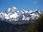 "+
"
"+
" "+
"
"+
" "+
"
"+
" "+
"
"+
" "+
"
"+
" "+
"
"+
" "+
"
"+
" "+
"",
julukbengali : "জুলুকঃ-খাঁজকাটা পাহাড়ের বন্ধুর প্রস্তরময় পথের মাঝে ১০,০০০ফুট উচ্চতায় অবস্থিত জুলুক পূর্ব সিকিম সিল্ক রুটের অন্যতম জনপ্রিয় জনপদ। পাহাড়ে পথের বেষ্টনী দেওয়া রাস্তা শুরু হয়েছে জুলুক থেকেই। আগে তিব্বত থেকে আসা ব্যবসায়ীরা এখানে বিশ্রাম নিতেন ফলে জুলুক অনেক পুরানো গ্রাম হিসাবে সবার কাছে পরিচিত। সীমান্তবর্তী এলাকা ও মিলিটারি স্ট্র্যাটিজিক পয়েন্ট হওয়ার ফলে এখানকার মিলিটারি গুরুত্ব অনেক, তাই এখানে মিলিটারি ক্যাম্প আছে এবং সেখান থেকেই গ্রামে বিদ্যুৎ সরবরাহ করা হয়। এখান থেকে কাঞ্চনজঙ্ঘার সূর্যোদয়ের অপার সৌন্দর্য উপভোগ করা যায়। তবে কিছুটা ওপরে থাম্বি ভিউ পয়েন্ট থেকে পুরো কাঞ্চনজঙ্ঘাকে আরও ভালো ভাবে দেখা যায়। জুলুক থেকে অনেক পরিদর্শকই পদমচেন, লুংথাং, নাথাং, টুকলা ভ্যালি,, পুরানো বাবা মন্দির হয়ে কুপুপ লেক গিয়ে আবার ফিরে আসেন। "+
"Read More..."+ "
"+
"",
julukbengali : "জুলুকঃ-খাঁজকাটা পাহাড়ের বন্ধুর প্রস্তরময় পথের মাঝে ১০,০০০ফুট উচ্চতায় অবস্থিত জুলুক পূর্ব সিকিম সিল্ক রুটের অন্যতম জনপ্রিয় জনপদ। পাহাড়ে পথের বেষ্টনী দেওয়া রাস্তা শুরু হয়েছে জুলুক থেকেই। আগে তিব্বত থেকে আসা ব্যবসায়ীরা এখানে বিশ্রাম নিতেন ফলে জুলুক অনেক পুরানো গ্রাম হিসাবে সবার কাছে পরিচিত। সীমান্তবর্তী এলাকা ও মিলিটারি স্ট্র্যাটিজিক পয়েন্ট হওয়ার ফলে এখানকার মিলিটারি গুরুত্ব অনেক, তাই এখানে মিলিটারি ক্যাম্প আছে এবং সেখান থেকেই গ্রামে বিদ্যুৎ সরবরাহ করা হয়। এখান থেকে কাঞ্চনজঙ্ঘার সূর্যোদয়ের অপার সৌন্দর্য উপভোগ করা যায়। তবে কিছুটা ওপরে থাম্বি ভিউ পয়েন্ট থেকে পুরো কাঞ্চনজঙ্ঘাকে আরও ভালো ভাবে দেখা যায়। জুলুক থেকে অনেক পরিদর্শকই পদমচেন, লুংথাং, নাথাং, টুকলা ভ্যালি,, পুরানো বাবা মন্দির হয়ে কুপুপ লেক গিয়ে আবার ফিরে আসেন। "+
"Read More..."+ " "+
"
"+
" "+
"
"+
" "+
"
"+
" "+
"
"+
" "+
"
"+
" "+
"
"+
" "+
"
"+
" "+
"",
mankhimbengali : "মাংখিমঃ-দালাপচাঁদ গ্রামের ওপরে প্রকৃতির এক নাটকীয় রঙ্গমঞ্চে অবস্থিত, অতি ছোট্ট একটা জনপদের নাম মাংখিম। গ্রামটা মাংখিম ভিউ-পয়েন্টের ঠিক নীচেই অবস্থিত যেখান থেকে দৃশ্যমান হয় অত্যন্ত জনপ্রিয় ভ্রমণ-স্থান আরিটার। মাংখিম থেকে এখনও অনুভব করা যায় প্রকৃতির সেই অনাবৃত আদিম রূপ যা মানুষের মনে সাময়িকভাবে হলেও এনে দেয় এক অনাবিল আনন্দ-স্রোত। গ্রামের নীচেই রয়েছে লামপোখরি লেক যার পান্না-সবুজ জল ও কাঞ্চনজঙ্ঘার চোখ ধাঁধানো সৌন্দর্যের স্ফুলিঙ্গ মানুষকে করে দেয় বাকরুদ্ধ। আর এই সৌন্দর্যকে পরিকীর্ণ করে আছে আরিটার মনাস্ট্রি ও পাহাড়ের মাথায় থাকা এক ছোট্ট শিব মন্দির। শহরের কোলাহল ও দৈনন্দিন প্রতিযোগিতামূলক জীবন থেকে এই শান্ত পরিবেশে কয়েকটা দিন থাকলে মানুষ পাবে নতুনভাবে বাঁচার ইন্ধন। ঘন জঙ্গলের মধ্যে পাখির ডাক শুনতে শুনতে কখন যে সন্ধ্যা গড়িয়ে যাবে তা টেরও পাওয়া যায় না। "+
"Read More..."+ "
"+
"",
mankhimbengali : "মাংখিমঃ-দালাপচাঁদ গ্রামের ওপরে প্রকৃতির এক নাটকীয় রঙ্গমঞ্চে অবস্থিত, অতি ছোট্ট একটা জনপদের নাম মাংখিম। গ্রামটা মাংখিম ভিউ-পয়েন্টের ঠিক নীচেই অবস্থিত যেখান থেকে দৃশ্যমান হয় অত্যন্ত জনপ্রিয় ভ্রমণ-স্থান আরিটার। মাংখিম থেকে এখনও অনুভব করা যায় প্রকৃতির সেই অনাবৃত আদিম রূপ যা মানুষের মনে সাময়িকভাবে হলেও এনে দেয় এক অনাবিল আনন্দ-স্রোত। গ্রামের নীচেই রয়েছে লামপোখরি লেক যার পান্না-সবুজ জল ও কাঞ্চনজঙ্ঘার চোখ ধাঁধানো সৌন্দর্যের স্ফুলিঙ্গ মানুষকে করে দেয় বাকরুদ্ধ। আর এই সৌন্দর্যকে পরিকীর্ণ করে আছে আরিটার মনাস্ট্রি ও পাহাড়ের মাথায় থাকা এক ছোট্ট শিব মন্দির। শহরের কোলাহল ও দৈনন্দিন প্রতিযোগিতামূলক জীবন থেকে এই শান্ত পরিবেশে কয়েকটা দিন থাকলে মানুষ পাবে নতুনভাবে বাঁচার ইন্ধন। ঘন জঙ্গলের মধ্যে পাখির ডাক শুনতে শুনতে কখন যে সন্ধ্যা গড়িয়ে যাবে তা টেরও পাওয়া যায় না। "+
"Read More..."+ " "+
"
"+
" "+
"
"+
" "+
"
"+
" "+
"
"+
" "+
"
"+
" "+
"
"+
" "+
"
"+
" "+
"",
versaybengali : "ভার্সেঃ-ভার্সে সিকিমের একেবারে পশ্চিম সীমান্তে, প্রায় পশ্চিমবঙ্গ লাগোয় এক জায়গা, যা রডোডেনড্রন ফুলের জন্যে বিখ্যাত। এটা একটা বিশাল ১০৪ বর্গ কিমি রডোডেনড্রন স্যাঙ্কচুয়ারি, যা মার্চের মাঝামাঝি থেকে এপ্রিলের মাঝামাঝি পর্যন্ত, ফুলের মরসুমে, ভ্রমণার্থীদের আকর্ষণ করে। রক্ত লাল থেকে দুধ সাদা বিভিন্ন রঙের ৬০০ রকমের রডোডেনড্রন ফুলের সমারোহে পুরো বন জ্বলজ্বল করে। আবার এই অভয়ারণ্যেই রয়েছে বিরল উদ্ভিদজগত ও প্রাণীজগতের আবাস যার মধ্যে বিলুপ্তপ্রায় প্রাণী রেড পান্ডা উল্লেখযোগ্য। রয়েছে অর্কিডের বৈচিত্র্য আর বিভিন্ন রকমের পাখির ঠিকানা। ঠিক বিপরীতে রয়েছে কাঞ্চনজঙ্ঘা ম্যাসিফের সুউচ্চ পর্বতশৃঙ্গের হাতছানি। সূর্যোদয়ে রঙের খেলা দেখা সত্যিই একটি অবিস্মরণীয় অভিজ্ঞতা। ভার্সে রডোডেনড্রন অভয়ারণ্য সার্কিট ট্রেক টেথিসের হিমায়িত তরঙ্গের একটা অসাধারণ দৃশ্য দেখায়। ৩,৬০০ মিটার উচ্চতায় দাঁড়িয়ে ৮,০০০ মিটার উচ্চতার ঢেউ খেলানো স্তরগুলোয় পৃথিবীর সর্বোচ্চ পর্বতশৃঙ্গের চারটে একসাথে মিলিত হয়, যার মধ্যমণি পৃথিবীর দ্বিতীয় সর্বোচ্চ পর্বতশৃঙ্গ কাঞ্চনজঙ্ঘা। বাকিগুলো মাউন্ট এভারেস্ট, মাউন্ট লোৎসে এবং মাকালু। তবে এখান থেকে কাঞ্চনজঙ্ঘাকেই সবথেকে কাছে ও সুন্দর দেখায়। বাকিরা তুলনায় অনেক ছোট ও দূরে দেখা যায়।ভার্সে, সিঙ্গালীলা জাতীয় উদ্যানের অন্তর্গত, যার পশ্চিম প্রান্তে রয়েছে নেপাল সীমান্ত এবং দক্ষিণে পশ্চিমবঙ্গ রাজ্য। রামাম খোলা বা নদী, সিকিম ও পশ্চিমবঙ্গকে ভাগ করেছে। এখান থেকে অনেক সুন্দর সুন্দর ট্রেক করা যায় যা অ্যাডভেঞ্চার প্রেমীদের আকর্ষণ করে। মিনিট পনের হাঁটলেই পাওয়া যাবে ১০০ ডিগ্রি উন্মুক্ত এক ক্যানভাসে প্রকৃতির খেয়ালী তুলির টানে আঁকা সুউচ্চ পর্বতমালা কাঞ্চনজঙ্ঘার ছবি। পাঁচ কিমি দূরে রয়েছে প্রকৃতির অকৃপণ দানে তৈরি হওয়া নীল জলের লেক গুরাসতাল। নৈসর্গিক বৈচিত্রের মধ্যে আর একটু হেঁটে ফুটেধারা গেলে, চলে যাওয়া যাবে প্রাকৃতিক সৌন্দর্যের নাট্যমঞ্চের আরও দুই রমণীয়ার কাছে - সোরেং ও হি-বার্মোইক। আরও বেশি চাইলে, যেতে পারা যাবে দেওলিঙ্গা ধাপ, জড়িবুটি, থুলধাপ, কালিঝাড় ইত্যাদি হয়ে সিঙ্গালীলা পাস ও তারপর ফালুট, সান্দাকফু ইত্যাদি। তবে সিঙ্গালীলা ট্রেক মনের মধ্যে রেখাপাত করে যাবে তার প্রাকৃতিক সৌন্দর্যের জন্যে। কি নেই তাতে – ঝর্ণা, নদী, গহন অরণ্য, সবুজ গালচে পাতা ভ্যলি, সুউচ্চ পর্বতমালা, নীল আকাশে সাদা মেঘের আনাগোনা, পাখির ডাকে মুখরিত এলাকা, প্রকৃতির নিজের হাতে লেখা উপন্যাসে বিরামচিহ্নের মতো ছোট ছোট গ্রাম ও আরো অনেক কিছু যা আমার মতো নগন্য মানুষের পক্ষে বর্ণনা করা অসম্ভব। ভার্সেতে থাকার জন্যে নিজের টেন্ট ও খাবাররে সংস্থান নিজেকেই করতে হবে। আর তা নইলে একমাত্র থাকার জায়গা গুরাসকুঞ্জের ডরমিটরি। কিছু টেন্টও ভাড়া পাওয়া যায়। খুব ভিড় হয় ছুটির দিনে, তাই থাকার ব্যবস্থা আগে থেকে করা ভাল। তবে এখানে থাকার ব্যবস্থা অত্যন্ত সীমিত স্বাচ্ছন্দ্যের ভিত্তিতে। যেমন থাকার প্রাইভেট ঘর নেই, টয়লেট ইন্ডিয়ান, লাগাতার জলের যোগান নেই, রাত্রে মোমের আলোই ভরসা ইত্যাদি। বস্তুত, নাগরিক সভ্যতার যান্ত্রিক জীবনযাপন থেকে শত যোজন দূরে বেঁচে থাকার এই একমাত্র জায়গা, যেখানে স্বাচ্ছন্দ্য সীমিত হলেও বিস্তৃতি অসীম।যদি কেউ আগে থাকতে বুক করতে চান তবে যোগাযোগ করুনঃ- সামদিং শেরপা, মোবাইল +৯১ ৭৫৫১৮৭৮৯৪৫, ৯৪৭৫৯১৯৭১৪। হিলে থেকে শুরু হয় ভার্সে ট্রেকিং। হিলেতে থাকার জন্যে সামদিং শেরপার দুটো ঘর আছে। জনপ্রতি ও দিনপ্রতি ১,০০০ টাকা খাওয়া থাকা সমেত। ভার্সেতেও থাকা খাওয়ার খরচ একই মানে ১,০০০ টাকা জনপ্রতি ও দিনপ্রতি।যাওয়া আসাঃ-নিউ জলপাইগুড়ি থেকে সরাসরি হিলে ভাড়া নেবে প্রায় ৫০০০ টাকা। শেয়ার জিপে জোরথাং ৩০০ টাকা ও সেখান থেকে রিবদি ২৫০ টাকা। সেখান থেকে গাড়ি বুক করে হিলে ১,০০০ টাকা। অথবা জোরথাং থেকে শেয়ার জিপে ওখরে নেমে এক রাত কাটিয়ে পরের দিন হিলে যাওয়া যেতে পারে। ওখরে থেকে হিলের ভাড়া একপিঠে ১,০০০ টাকা। হিলে থেকে রিবদি ১,৫০০ টাকা, ওখরে ১,০০০ টাকা। এই এলাকায় যত হোমস্টে আছে সবের ভাড়াই ১,০০০ টাকা জনপ্রতি ও দিনপ্রতি। ওখরেতে যদি কোন হোমস্টেতে কেউ থাকে, তবে সেই হোমস্টের মালিকও ভার্সেতে থাকার ব্যবস্থা করে দেয়। "+
"Read More..."+ "
"+
"",
versaybengali : "ভার্সেঃ-ভার্সে সিকিমের একেবারে পশ্চিম সীমান্তে, প্রায় পশ্চিমবঙ্গ লাগোয় এক জায়গা, যা রডোডেনড্রন ফুলের জন্যে বিখ্যাত। এটা একটা বিশাল ১০৪ বর্গ কিমি রডোডেনড্রন স্যাঙ্কচুয়ারি, যা মার্চের মাঝামাঝি থেকে এপ্রিলের মাঝামাঝি পর্যন্ত, ফুলের মরসুমে, ভ্রমণার্থীদের আকর্ষণ করে। রক্ত লাল থেকে দুধ সাদা বিভিন্ন রঙের ৬০০ রকমের রডোডেনড্রন ফুলের সমারোহে পুরো বন জ্বলজ্বল করে। আবার এই অভয়ারণ্যেই রয়েছে বিরল উদ্ভিদজগত ও প্রাণীজগতের আবাস যার মধ্যে বিলুপ্তপ্রায় প্রাণী রেড পান্ডা উল্লেখযোগ্য। রয়েছে অর্কিডের বৈচিত্র্য আর বিভিন্ন রকমের পাখির ঠিকানা। ঠিক বিপরীতে রয়েছে কাঞ্চনজঙ্ঘা ম্যাসিফের সুউচ্চ পর্বতশৃঙ্গের হাতছানি। সূর্যোদয়ে রঙের খেলা দেখা সত্যিই একটি অবিস্মরণীয় অভিজ্ঞতা। ভার্সে রডোডেনড্রন অভয়ারণ্য সার্কিট ট্রেক টেথিসের হিমায়িত তরঙ্গের একটা অসাধারণ দৃশ্য দেখায়। ৩,৬০০ মিটার উচ্চতায় দাঁড়িয়ে ৮,০০০ মিটার উচ্চতার ঢেউ খেলানো স্তরগুলোয় পৃথিবীর সর্বোচ্চ পর্বতশৃঙ্গের চারটে একসাথে মিলিত হয়, যার মধ্যমণি পৃথিবীর দ্বিতীয় সর্বোচ্চ পর্বতশৃঙ্গ কাঞ্চনজঙ্ঘা। বাকিগুলো মাউন্ট এভারেস্ট, মাউন্ট লোৎসে এবং মাকালু। তবে এখান থেকে কাঞ্চনজঙ্ঘাকেই সবথেকে কাছে ও সুন্দর দেখায়। বাকিরা তুলনায় অনেক ছোট ও দূরে দেখা যায়।ভার্সে, সিঙ্গালীলা জাতীয় উদ্যানের অন্তর্গত, যার পশ্চিম প্রান্তে রয়েছে নেপাল সীমান্ত এবং দক্ষিণে পশ্চিমবঙ্গ রাজ্য। রামাম খোলা বা নদী, সিকিম ও পশ্চিমবঙ্গকে ভাগ করেছে। এখান থেকে অনেক সুন্দর সুন্দর ট্রেক করা যায় যা অ্যাডভেঞ্চার প্রেমীদের আকর্ষণ করে। মিনিট পনের হাঁটলেই পাওয়া যাবে ১০০ ডিগ্রি উন্মুক্ত এক ক্যানভাসে প্রকৃতির খেয়ালী তুলির টানে আঁকা সুউচ্চ পর্বতমালা কাঞ্চনজঙ্ঘার ছবি। পাঁচ কিমি দূরে রয়েছে প্রকৃতির অকৃপণ দানে তৈরি হওয়া নীল জলের লেক গুরাসতাল। নৈসর্গিক বৈচিত্রের মধ্যে আর একটু হেঁটে ফুটেধারা গেলে, চলে যাওয়া যাবে প্রাকৃতিক সৌন্দর্যের নাট্যমঞ্চের আরও দুই রমণীয়ার কাছে - সোরেং ও হি-বার্মোইক। আরও বেশি চাইলে, যেতে পারা যাবে দেওলিঙ্গা ধাপ, জড়িবুটি, থুলধাপ, কালিঝাড় ইত্যাদি হয়ে সিঙ্গালীলা পাস ও তারপর ফালুট, সান্দাকফু ইত্যাদি। তবে সিঙ্গালীলা ট্রেক মনের মধ্যে রেখাপাত করে যাবে তার প্রাকৃতিক সৌন্দর্যের জন্যে। কি নেই তাতে – ঝর্ণা, নদী, গহন অরণ্য, সবুজ গালচে পাতা ভ্যলি, সুউচ্চ পর্বতমালা, নীল আকাশে সাদা মেঘের আনাগোনা, পাখির ডাকে মুখরিত এলাকা, প্রকৃতির নিজের হাতে লেখা উপন্যাসে বিরামচিহ্নের মতো ছোট ছোট গ্রাম ও আরো অনেক কিছু যা আমার মতো নগন্য মানুষের পক্ষে বর্ণনা করা অসম্ভব। ভার্সেতে থাকার জন্যে নিজের টেন্ট ও খাবাররে সংস্থান নিজেকেই করতে হবে। আর তা নইলে একমাত্র থাকার জায়গা গুরাসকুঞ্জের ডরমিটরি। কিছু টেন্টও ভাড়া পাওয়া যায়। খুব ভিড় হয় ছুটির দিনে, তাই থাকার ব্যবস্থা আগে থেকে করা ভাল। তবে এখানে থাকার ব্যবস্থা অত্যন্ত সীমিত স্বাচ্ছন্দ্যের ভিত্তিতে। যেমন থাকার প্রাইভেট ঘর নেই, টয়লেট ইন্ডিয়ান, লাগাতার জলের যোগান নেই, রাত্রে মোমের আলোই ভরসা ইত্যাদি। বস্তুত, নাগরিক সভ্যতার যান্ত্রিক জীবনযাপন থেকে শত যোজন দূরে বেঁচে থাকার এই একমাত্র জায়গা, যেখানে স্বাচ্ছন্দ্য সীমিত হলেও বিস্তৃতি অসীম।যদি কেউ আগে থাকতে বুক করতে চান তবে যোগাযোগ করুনঃ- সামদিং শেরপা, মোবাইল +৯১ ৭৫৫১৮৭৮৯৪৫, ৯৪৭৫৯১৯৭১৪। হিলে থেকে শুরু হয় ভার্সে ট্রেকিং। হিলেতে থাকার জন্যে সামদিং শেরপার দুটো ঘর আছে। জনপ্রতি ও দিনপ্রতি ১,০০০ টাকা খাওয়া থাকা সমেত। ভার্সেতেও থাকা খাওয়ার খরচ একই মানে ১,০০০ টাকা জনপ্রতি ও দিনপ্রতি।যাওয়া আসাঃ-নিউ জলপাইগুড়ি থেকে সরাসরি হিলে ভাড়া নেবে প্রায় ৫০০০ টাকা। শেয়ার জিপে জোরথাং ৩০০ টাকা ও সেখান থেকে রিবদি ২৫০ টাকা। সেখান থেকে গাড়ি বুক করে হিলে ১,০০০ টাকা। অথবা জোরথাং থেকে শেয়ার জিপে ওখরে নেমে এক রাত কাটিয়ে পরের দিন হিলে যাওয়া যেতে পারে। ওখরে থেকে হিলের ভাড়া একপিঠে ১,০০০ টাকা। হিলে থেকে রিবদি ১,৫০০ টাকা, ওখরে ১,০০০ টাকা। এই এলাকায় যত হোমস্টে আছে সবের ভাড়াই ১,০০০ টাকা জনপ্রতি ও দিনপ্রতি। ওখরেতে যদি কোন হোমস্টেতে কেউ থাকে, তবে সেই হোমস্টের মালিকও ভার্সেতে থাকার ব্যবস্থা করে দেয়। "+
"Read More..."+ " "+
"
"+
" "+
"
"+
" "+
"
"+
" "+
"
"+
" "+
"
"+
" "+
"
"+
" "+
"
"+
" "+
"",
okhraybengali : "ওখড়েঃ-মনোরম এবং মনোমুগ্ধকর ওখড়ে পশ্চিম সিকিমের ভার্সে রডোডেনড্রন স্যাঙ্কচুয়ারি কাছে অবস্থিত একটা ছোট অনামা গ্রাম। এই গ্রামের বেশিরভাগই শেরপা ও ভুটিয়া অধ্যুষিত ও তাদের মূল জীবিকা কৃষিকার্য। প্রাকৃতিক সৌন্দর্য ও শান্ত পরিবেশের জন্যে এই গ্রাম ভ্রমণার্থীদের কাছে বেশি পছন্দের। নিকটতম জনপদ রয়েছে প্রায় ২০ কিলোমিটার দূরে সোম্বেরিয়ায়। ওখড়ে বিখ্যাত হয়ে উঠেছে ভার্সে রডোডেনড্রন অভয়ারণ্যের প্রবেশদ্বার এবং সেই সঙ্গে চেওয়া ট্রেলসের মিলনস্থল যা দক্ষিণে দার্জিলিং, উত্তরে সিকিম এবং পশ্চিমে নেপালের দিকে নিয়ে যায়। প্রতি বছর মার্চের মাঝামাঝি থেকে এপ্রিলের মাঝামাঝি পর্যন্ত, অনেক প্রকৃতিপ্রেমী, অ্যাডভেঞ্চাচারিষ্ট এবং উদ্ভিদবিদরা মহিমান্বিত রডোডেনড্রনের গৌরব অনুভব করতে এই ছোট্ট গ্রামে আসেন ও আশেপাশের বনের লাল এবং গোলাপি রঙের প্রাণবন্ত ছায়ায় জীবনকে রাঙিয়ে নিয়ে যান। চতুর্দিকের বনফুল বিনম্রভাবে অভ্যাগতকে শুভেচ্ছা জানায়। পরিষ্কার আকাশ ও মনোরম তাপমাত্রা এই আবেদনে শান্তির এক নতুন মাত্রা যোগ করে।প্রকৃতি সিকিম রাজ্যটার প্রতিটা বাঁক বেশ সুন্দর করে সাজিয়ে রেখেছে। গুটিকতক ছড়ানো ছিটনো কাঠের বাড়ি নিয়ে তৈরি এই ছোট্ট গ্রামটাও এক অনন্য টুরিস্ট স্পট। এখন কিছু কংক্রিটের বাসস্থান গড়ে উঠলেও তা গ্রামের সৌন্দর্যে এখনও শহুরে প্রভাব ফেলতে পারেনি। এখনও নিজের মত করে দিব্যি সতেজ ও সুন্দর রয়েছে ওখড়ে গ্রামটা। এখানকার বেশিরভাগ হোমস্টেতে অকারণ বাহুল্য বা বিলাসিতার চিহ্নমাত্র নেই। তবে রয়েছে স্বাভাবিক জীবনযাপনের পরিচ্ছন্ন ব্যবস্থাপনা। আর যারা একটু ভোজন রসিক, তাঁরা খাঁটি সিকিমিজ খাবারের লোভেই শুধুমাত্র চলে যেতে পারেন। অসাধারণ এই গ্রামটায় মেঘ পাহাড়ের আলিঙ্গনের রঙিন ছবি দেখা, চুল এলোমেলো করা ঠাণ্ডা বাতাসে সোঁদা জংলী গন্ধ পরখ করা, পাখির গান শোনা, গ্রামের শিশুদের সঙ্গে খেলা করা (দু-একটা চকোলেট অবশ্যই দিতে হবে), আর আরও অনুভবী হলে পাহাড়ের সঙ্গে গল্প করা যেতে পারে। আর এসব কিছু করতে ইচ্ছে না করলে শুধু বসে বসেই সারাদিন কাটিয়ে দেওয়া যায়। আদিগন্ত সবুজ গালচে বেছানো নিরিবিলি এই গ্রামে ঘুম ভাঙায় হিমালয়ের অচিন পাখিরা। দু-তিন দিনের ছুটি পেলে বেড়িয়ে নেওয়া যায় এই মেঘ পাহাড়ের দেশ, সঙ্গে অবশ্যই থাকবে হিলে ও ভার্সে। একটু সময় থাকলে রিবদিটাও জুড়ে নেওয়া যায়। হেঁটে বা গাড়িতে চলে যাওয়া যেতে পারে ওখড়ে মঠে। ওখড়ের উগেন থংমিওংলিং মঠ ১৯০৫ সালে শেরপা বৌদ্ধ অনুগামীদের দ্বারা নির্মিত হয়েছিল। এটা ওখড়ে গ্রামের ওপরে একটা পাহাড়ে অবস্থিত এবং এখানে সারা বছর ধরে বিভিন্ন ধর্মীয় অনুষ্ঠান অনুষ্ঠিত হয়। ১৯৬৬ সালে ডুকপা লামা এই মঠের দায়িত্ব নেন ও একটা বৌদ্ধ স্কুল তৈরি করেন। ১৯৮৬ সালে এই মঠের দায়িত্ব, গ্যাংটকের দদ্রুবচেন রিংপনচেন মনাস্ট্রির কাছে হস্তান্তর করা হয়েছিল। এটা তিব্বতি বৌদ্ধধর্মের নাইংমাপা সম্প্রদায়কে অনুসরণ করে।ওখড়ের ঠিক উল্টো দিকের পাহাড়টাই দার্জিলিং। নির্জন ওখড়ের নিঝুম রাতকে বড় বেশি মায়াবী করে দেয় দূর পাহাড়ের ওই শৈলশহর। দার্জিলিঙের এক ঝাঁক ঝিকমিকে জোনাকি আলোর সমারোহ এসে রাতের তারার সঙ্গে মিশে যায়। সঙ্গে যদি থাকে প্রেয়সী, তবে জ্যোৎস্না রাতে ওখড়ে নতুন এক অনুক্ত প্রেমের সাক্ষী হয়ে থেকে যাবে। নির্ভুল না হলেও অনেকেই ভালোবেসে ওখড়েকে ল্যান্ড অফ রডোডেনড্রন বলে থাকেন। মধ্য মার্চ থেকে মধ্য এপ্রিল এই এক মাস রডোডেনড্রন ফুলের সিজন। এই সময় টুরিস্টদের আকর্ষণের কেন্দ্রবিন্দু হয়ে ওঠে ভার্সে রডোডেনড্রন স্যাঙ্কচুয়ারি। ওখড়ে থেকে হিলের দূরত্ব মাত্র ১৩ কিমি। গাড়ী হিলে অবধিই যাবে তারপর হাটা পথে গভীর ঘন অন্ধকার জঙ্গলের পথে চার কিমি ট্রেক করে পৌঁছতে হবে ভার্সে। "+
"Read More..."+ "
"+
"",
okhraybengali : "ওখড়েঃ-মনোরম এবং মনোমুগ্ধকর ওখড়ে পশ্চিম সিকিমের ভার্সে রডোডেনড্রন স্যাঙ্কচুয়ারি কাছে অবস্থিত একটা ছোট অনামা গ্রাম। এই গ্রামের বেশিরভাগই শেরপা ও ভুটিয়া অধ্যুষিত ও তাদের মূল জীবিকা কৃষিকার্য। প্রাকৃতিক সৌন্দর্য ও শান্ত পরিবেশের জন্যে এই গ্রাম ভ্রমণার্থীদের কাছে বেশি পছন্দের। নিকটতম জনপদ রয়েছে প্রায় ২০ কিলোমিটার দূরে সোম্বেরিয়ায়। ওখড়ে বিখ্যাত হয়ে উঠেছে ভার্সে রডোডেনড্রন অভয়ারণ্যের প্রবেশদ্বার এবং সেই সঙ্গে চেওয়া ট্রেলসের মিলনস্থল যা দক্ষিণে দার্জিলিং, উত্তরে সিকিম এবং পশ্চিমে নেপালের দিকে নিয়ে যায়। প্রতি বছর মার্চের মাঝামাঝি থেকে এপ্রিলের মাঝামাঝি পর্যন্ত, অনেক প্রকৃতিপ্রেমী, অ্যাডভেঞ্চাচারিষ্ট এবং উদ্ভিদবিদরা মহিমান্বিত রডোডেনড্রনের গৌরব অনুভব করতে এই ছোট্ট গ্রামে আসেন ও আশেপাশের বনের লাল এবং গোলাপি রঙের প্রাণবন্ত ছায়ায় জীবনকে রাঙিয়ে নিয়ে যান। চতুর্দিকের বনফুল বিনম্রভাবে অভ্যাগতকে শুভেচ্ছা জানায়। পরিষ্কার আকাশ ও মনোরম তাপমাত্রা এই আবেদনে শান্তির এক নতুন মাত্রা যোগ করে।প্রকৃতি সিকিম রাজ্যটার প্রতিটা বাঁক বেশ সুন্দর করে সাজিয়ে রেখেছে। গুটিকতক ছড়ানো ছিটনো কাঠের বাড়ি নিয়ে তৈরি এই ছোট্ট গ্রামটাও এক অনন্য টুরিস্ট স্পট। এখন কিছু কংক্রিটের বাসস্থান গড়ে উঠলেও তা গ্রামের সৌন্দর্যে এখনও শহুরে প্রভাব ফেলতে পারেনি। এখনও নিজের মত করে দিব্যি সতেজ ও সুন্দর রয়েছে ওখড়ে গ্রামটা। এখানকার বেশিরভাগ হোমস্টেতে অকারণ বাহুল্য বা বিলাসিতার চিহ্নমাত্র নেই। তবে রয়েছে স্বাভাবিক জীবনযাপনের পরিচ্ছন্ন ব্যবস্থাপনা। আর যারা একটু ভোজন রসিক, তাঁরা খাঁটি সিকিমিজ খাবারের লোভেই শুধুমাত্র চলে যেতে পারেন। অসাধারণ এই গ্রামটায় মেঘ পাহাড়ের আলিঙ্গনের রঙিন ছবি দেখা, চুল এলোমেলো করা ঠাণ্ডা বাতাসে সোঁদা জংলী গন্ধ পরখ করা, পাখির গান শোনা, গ্রামের শিশুদের সঙ্গে খেলা করা (দু-একটা চকোলেট অবশ্যই দিতে হবে), আর আরও অনুভবী হলে পাহাড়ের সঙ্গে গল্প করা যেতে পারে। আর এসব কিছু করতে ইচ্ছে না করলে শুধু বসে বসেই সারাদিন কাটিয়ে দেওয়া যায়। আদিগন্ত সবুজ গালচে বেছানো নিরিবিলি এই গ্রামে ঘুম ভাঙায় হিমালয়ের অচিন পাখিরা। দু-তিন দিনের ছুটি পেলে বেড়িয়ে নেওয়া যায় এই মেঘ পাহাড়ের দেশ, সঙ্গে অবশ্যই থাকবে হিলে ও ভার্সে। একটু সময় থাকলে রিবদিটাও জুড়ে নেওয়া যায়। হেঁটে বা গাড়িতে চলে যাওয়া যেতে পারে ওখড়ে মঠে। ওখড়ের উগেন থংমিওংলিং মঠ ১৯০৫ সালে শেরপা বৌদ্ধ অনুগামীদের দ্বারা নির্মিত হয়েছিল। এটা ওখড়ে গ্রামের ওপরে একটা পাহাড়ে অবস্থিত এবং এখানে সারা বছর ধরে বিভিন্ন ধর্মীয় অনুষ্ঠান অনুষ্ঠিত হয়। ১৯৬৬ সালে ডুকপা লামা এই মঠের দায়িত্ব নেন ও একটা বৌদ্ধ স্কুল তৈরি করেন। ১৯৮৬ সালে এই মঠের দায়িত্ব, গ্যাংটকের দদ্রুবচেন রিংপনচেন মনাস্ট্রির কাছে হস্তান্তর করা হয়েছিল। এটা তিব্বতি বৌদ্ধধর্মের নাইংমাপা সম্প্রদায়কে অনুসরণ করে।ওখড়ের ঠিক উল্টো দিকের পাহাড়টাই দার্জিলিং। নির্জন ওখড়ের নিঝুম রাতকে বড় বেশি মায়াবী করে দেয় দূর পাহাড়ের ওই শৈলশহর। দার্জিলিঙের এক ঝাঁক ঝিকমিকে জোনাকি আলোর সমারোহ এসে রাতের তারার সঙ্গে মিশে যায়। সঙ্গে যদি থাকে প্রেয়সী, তবে জ্যোৎস্না রাতে ওখড়ে নতুন এক অনুক্ত প্রেমের সাক্ষী হয়ে থেকে যাবে। নির্ভুল না হলেও অনেকেই ভালোবেসে ওখড়েকে ল্যান্ড অফ রডোডেনড্রন বলে থাকেন। মধ্য মার্চ থেকে মধ্য এপ্রিল এই এক মাস রডোডেনড্রন ফুলের সিজন। এই সময় টুরিস্টদের আকর্ষণের কেন্দ্রবিন্দু হয়ে ওঠে ভার্সে রডোডেনড্রন স্যাঙ্কচুয়ারি। ওখড়ে থেকে হিলের দূরত্ব মাত্র ১৩ কিমি। গাড়ী হিলে অবধিই যাবে তারপর হাটা পথে গভীর ঘন অন্ধকার জঙ্গলের পথে চার কিমি ট্রেক করে পৌঁছতে হবে ভার্সে। "+
"Read More..."+ " "+
"
"+
" "+
"
"+
" "+
"
"+
" "+
"
"+
" "+
"
"+
" "+
"
"+
" "+
"
"+
" "+
"",
ribdibengali : "রিবদিঃ-পাহাড়ের ঢালে সুন্দরভাবে অবস্থিত রিবদি একটা ছোট গ্রাম, যার অর্থ হলো, রডোডেনড্রন ভ্যালি। গ্রামের বাড়িগুলো কাঠের তৈরি ও বিভিন্ন রঙের হয়। একটা পরিচিত সিকিমিজ ল্যান্ডস্কেপ হিসাবে, বাড়িগুলোর সবকটাতেই রয়েছে সুন্দর সুন্দর ফুলের বাগান, সামনের ছোট্ট জমিতে ধাপ চাষ করে তৈরি হয় অর্গানিক ফসল ও প্রতিটি মানুষ অতিথি বৎসল ও সিংহ হৃদয়। রিবদিতে বর্তমানে কয়েকটা হোমস্টে তৈরি হয়েছে যেখানে ট্যুরিস্টরা আরামে থাকতে পারেন। প্রতি হোমস্টের বাড়ির মালকিন রান্না ও খাওয়ার দায়িত্ব নেন ও পুরুষেরা ট্যুরিস্টদের স্থানীয় জায়গা ঘুরিয়ে দেখান। আবার প্রত্যেক হোমস্টের একটা নাম আছে ও তার একটা মানে আছে যা কোন এক বোর্ডে লেখা থাকে। বাসিন্দারা শেরপা, তামাং এবং রাই, ও বেশিরভাগই বৌদ্ধ। রিবদি এই অঞ্চল থেকে কয়েকটা ট্রেক শুরু করার জন্য উপযুক্ত পয়েন্ট যার মধ্যে গোর্কে ট্রেকারদের কাছে অতি পরিচিত। ভারেঙ থেকে গোর্কে আর একটা ছোট্ট কিন্তু সুন্দর ট্রেক। রিবদির বৌদ্ধ মন্দির এবং মঠ একটা দেখার জায়গা। ঐতিহ্যবাহী উৎসবগুলো সারা বছর ধরে এখানে পালিত হয় যার মধ্যে প্রধান গুরুত্বপূর্ণ অনুষ্ঠান হলো লুসার যা আমাদের নববর্ষের অনুরূপ। এটা শেরপা সম্প্রদায়ের নতুন বছর ও অনুষ্ঠিত হয় ফেব্রুয়ারিতে। গ্রামের ছোট ছোট দোকান ও রবিবারের হাট আর একটা দর্শনীয় জায়গা। হাটের দিন স্থানীয় বাজারে ইয়াক পনির, জামাকাপড়, ফল এবং সবজি ইত্যাদি পাওয়া যায়।তাজা বাতাস, তাজা জল, তাজা শাকসবজির স্বাদ গ্রহণ এবং স্থানীয় শেরপা সম্প্রদায়ের বিভিন্ন সাংস্কৃতিক আচার অনুষ্ঠান সম্বন্ধে জ্ঞান লাভ করতে গেলে এখানে কদিন থাকতে হবে। এখানে শেরপারা কিভাবে প্রাকৃতিক পরিবেশ সংরক্ষণ এবং তার সুরক্ষা করে তা দেখার জন্য আদর্শ জায়গা রিবদি। রডোডেনড্রন গাছ, সুন্দর পাখি এবং যদি কেউ সৌভাগ্যবান হ’ন তো রেড পাণ্ডা দেখার সুযোগ মেলে এখানে। জঙ্গলে অনেক ভালুক রয়েছে ফলে সন্ধ্যাবেলা সেখানে বেরনো সমস্যার হতে পারে। ইচ্ছে হলে বিশুদ্ধ রডোডেনড্রন ফুলের রস বা রডোডেনড্রন ওয়াইনের স্বাদ নেওয়া যেতে পারে তবে তা ওষুধের মতো খাওয়াই ভালো নইলে... "+
"Read More..."+ "
"+
"",
ribdibengali : "রিবদিঃ-পাহাড়ের ঢালে সুন্দরভাবে অবস্থিত রিবদি একটা ছোট গ্রাম, যার অর্থ হলো, রডোডেনড্রন ভ্যালি। গ্রামের বাড়িগুলো কাঠের তৈরি ও বিভিন্ন রঙের হয়। একটা পরিচিত সিকিমিজ ল্যান্ডস্কেপ হিসাবে, বাড়িগুলোর সবকটাতেই রয়েছে সুন্দর সুন্দর ফুলের বাগান, সামনের ছোট্ট জমিতে ধাপ চাষ করে তৈরি হয় অর্গানিক ফসল ও প্রতিটি মানুষ অতিথি বৎসল ও সিংহ হৃদয়। রিবদিতে বর্তমানে কয়েকটা হোমস্টে তৈরি হয়েছে যেখানে ট্যুরিস্টরা আরামে থাকতে পারেন। প্রতি হোমস্টের বাড়ির মালকিন রান্না ও খাওয়ার দায়িত্ব নেন ও পুরুষেরা ট্যুরিস্টদের স্থানীয় জায়গা ঘুরিয়ে দেখান। আবার প্রত্যেক হোমস্টের একটা নাম আছে ও তার একটা মানে আছে যা কোন এক বোর্ডে লেখা থাকে। বাসিন্দারা শেরপা, তামাং এবং রাই, ও বেশিরভাগই বৌদ্ধ। রিবদি এই অঞ্চল থেকে কয়েকটা ট্রেক শুরু করার জন্য উপযুক্ত পয়েন্ট যার মধ্যে গোর্কে ট্রেকারদের কাছে অতি পরিচিত। ভারেঙ থেকে গোর্কে আর একটা ছোট্ট কিন্তু সুন্দর ট্রেক। রিবদির বৌদ্ধ মন্দির এবং মঠ একটা দেখার জায়গা। ঐতিহ্যবাহী উৎসবগুলো সারা বছর ধরে এখানে পালিত হয় যার মধ্যে প্রধান গুরুত্বপূর্ণ অনুষ্ঠান হলো লুসার যা আমাদের নববর্ষের অনুরূপ। এটা শেরপা সম্প্রদায়ের নতুন বছর ও অনুষ্ঠিত হয় ফেব্রুয়ারিতে। গ্রামের ছোট ছোট দোকান ও রবিবারের হাট আর একটা দর্শনীয় জায়গা। হাটের দিন স্থানীয় বাজারে ইয়াক পনির, জামাকাপড়, ফল এবং সবজি ইত্যাদি পাওয়া যায়।তাজা বাতাস, তাজা জল, তাজা শাকসবজির স্বাদ গ্রহণ এবং স্থানীয় শেরপা সম্প্রদায়ের বিভিন্ন সাংস্কৃতিক আচার অনুষ্ঠান সম্বন্ধে জ্ঞান লাভ করতে গেলে এখানে কদিন থাকতে হবে। এখানে শেরপারা কিভাবে প্রাকৃতিক পরিবেশ সংরক্ষণ এবং তার সুরক্ষা করে তা দেখার জন্য আদর্শ জায়গা রিবদি। রডোডেনড্রন গাছ, সুন্দর পাখি এবং যদি কেউ সৌভাগ্যবান হ’ন তো রেড পাণ্ডা দেখার সুযোগ মেলে এখানে। জঙ্গলে অনেক ভালুক রয়েছে ফলে সন্ধ্যাবেলা সেখানে বেরনো সমস্যার হতে পারে। ইচ্ছে হলে বিশুদ্ধ রডোডেনড্রন ফুলের রস বা রডোডেনড্রন ওয়াইনের স্বাদ নেওয়া যেতে পারে তবে তা ওষুধের মতো খাওয়াই ভালো নইলে... "+
"Read More..."+ " "+
"
"+
" "+
"
"+
" "+
"
"+
" "+
"
"+
" "+
"
"+
" "+
"
"+
" "+
"
"+
" "+
"",
gurdongmarbengali : "গুরদোংমার লেকঃ-ইয়াকদের দেশে, তুষার পর্বতমালার কোলে, গুরদোংমার লেক, একটা উজ্জ্বল আকাশী রত্ন ও সিকিমের আদিম সৌন্দর্যের হ্রদগুলোর মধ্যে একটা, যার উত্তরে কয়েক কিলোমিটারের মধ্যেই রয়েছে চীন অধিকৃত তিব্বত সীমান্ত। রৌদ্রোজ্জ্বল দিনে হ্রদটা এক স্ফটিক স্বচ্ছ আয়নার মতো, নীল আকাশ, এবং চারপাশের বরফের শিখরগুলোকে প্রতিফলিত করে। লেকটা খাংচেংয়াও রেঞ্জের উত্তর দিকে ও ভারতের সবচেয়ে উঁচু পর্বতশৃঙ্গ মাউন্ট কাঞ্চনজঙ্ঘা রেঞ্জ এবং মাউন্ট সিনিয়ালচুর মধ্যে অবস্থিত। এখান থেকে এই পর্বতশৃঙ্গগুলোর অপূর্ব দৃশ্য পরখ করা যায়। ব্রিটিশ পর্বতারোহী ডগলাস ফ্রেশফিল্ড এর সৌন্দর্যে মুগ্ধ হয়ে গিয়ে লিখেছিলেন 'পর্বত স্থাপত্যের সবচেয়ে চমৎকার সৃষ্টি ও বিশ্বের সবচেয়ে সুন্দর তুষার পর্বত'। ঝলমলে চূড়ার বিপরীতে রয়েছে অ্যালপাইন চারণভূমি এবং স্থানে স্থানে ঝোপঝাড় যা লেককে করেছে অন্য এক জাগতিক আকর্ষণের কেন্দ্রবিন্দু। ভ্রমণের সময় যদি ভাগ্য সহায় থাকে, তাহলে সুন্দর সাদা ব্রহ্মকমল দেখার সৌভাগ্য হবে, যা এক অলৌকিক নিরাময় বৈশিষ্ট্যের জন্যে পরিচিত। এই অঞ্চলে কিছু বিপন্ন প্রজাতি যেমন বুনো গাধা প্রজাতির মধ্যে বৃহত্তম কিয়াং, গ্রেট তিব্বতি ভেড়া, তিব্বতি গাজেল, তিব্বতি নেকড়ে এবং অধরা তুষার চিতাবাঘের আবাসস্থল। ৫,১৮৩ মিটার বা ১৭,১০৪ ফুট উচ্চতায় পাহাড়ের মাঝখানে অবস্থিত, হিমায়িত এই অ্যালপাইন হ্রদ তিস্তা নদীর প্রধান উৎসগুলোর মধ্যে একটা। এই লেক সম্ভবত গ্রহের সবচেয়ে আশ্চর্যজনক হ্রদ। পবিত্র হ্রদের একটা মাত্র স্থান বাদ দিয়ে বাকি অংশ শীতকালে শক্ত বরফ হয়ে যায়। এই আশ্চর্য ঘটনা বৌদ্ধ ধর্মাবলম্বী মানুষজনের প্রবল ধর্মীয় বিশ্বাসকে বিশেষভাবে বিশ্বাসযোগ্য করে তোলে। হ্রদের স্বাদযুক্ত জল সন্তানহীন দম্পতিদের সন্তান প্রাপ্ত হওয়ার জন্যে সাহায্য করে বলে মানুষের বিশ্বাস। আশ্চর্যের বিষয় হল, গুরদোংমার লেকের কল্পনাকে সব ধর্মের মানুষজনই সমানভাবে শ্রদ্ধা করেন। বিশিষ্ট গুরু পদ্মসম্ভবের নামানুসারে হ্রদের নাম হয়েছে গুরদোংমার, যিনি তিব্বত সফরের সময় এই অঞ্চল অতিক্রম করেছিলেন বলে মনে করা হয়। গুরু পদ্মসম্ভব, গুরু রিনপোচে নামেও পরিচিত। এই হ্রদে যাবার রাস্তা বেশ রুক্ষ কিন্তু সুন্দর অ্যালপাইন চারণভূমি এবং মনোরম রডোডেনড্রন তাতে এক অন্য মাত্রা যোগ করে, ফলে যাত্রাপথ অনেক বেশী আকর্ষণীয় করে তোলে।কিংবদন্তি বলে যে স্থানীয় লোকদের আবেদনের কারণে, হ্রদটা গুরু পদ্মসম্ভবের আশীর্বাদের সূচীতে পড়ে। অতি উচ্চতায় অবস্থানের কারণে, হ্রদটা বছরের বেশিরভাগ সময় হিমায়িত থাকে। তাই স্থানীয় মানুষজন, গুরু পদ্মসম্ভবের কাছে সাহায্য চেয়েছিলেন, যাতে সারা বছর লেকের জল বরফমুক্ত থাকে। গুরু পদ্মসম্ভব হ্রদের একটা অংশে তাঁর হাত রেখেছিলেন, যে জায়গাটা শীতকালেও বরফমুক্ত থাকে, এবং এইভাবে স্থানীয় মানুষজন পানীয় জলের সমস্যা থেকে রেহাই পান। এই ঘটনার পর থেকে, হ্রদটাকে পবিত্র বলে মনে করা হয়, এবং তীর্থযাত্রীরা লেকের পবিত্র জল পাত্রে নিয়ে যেতে শুরু করেন। অন্য এক কাহিনী মতে, গুরু নানক পঞ্চদশ শতাব্দীতে এই হ্রদের মধ্য দিয়ে হেঁটে চলে গিয়েছিলেন, এবং যখন স্থানীয় মানুষজন জলের সমস্যা মেটানোর জন্যে প্রার্থনা করেন, তিনি তখন তাঁর হাঁটার লাঠি দিয়ে, এই হ্রদের একটা অংশ স্পর্শ করেছিলেন, এবং সেই থেকে এই হ্রদের ওই অংশটা সারা বছর ধরে বরফমুক্ত থাকে ও স্থানীয় মানুষজনকে পানীয় জল সরবরাহ করে। তিনি লেকের জলকে শক্তি এবং বীরত্বের প্রতীক হওয়ার আশীর্বাদও করেছিলেন, তাই এই জল সবার কাছে অত্যন্ত পবিত্র বলে মনে করা হয়।গ্যাংটক থেকে গুরদোংমার হ্রদে পৌঁছনোর জন্যে সবচেয়ে ভাল বিকল্প হল লাচেনে রাত্রিযাপন করা। দু জায়গার মধ্যে দূরত্ব প্রায় ১২০ কিলোমিটার, যা ঘণ্টা পাঁচেকের মধ্যে পৌঁছে যাওয়া যায়। লাচেন একটা মনোরম পাহাড়ি গ্রাম, এবং গ্যাংটক থেকে হ্রদে সরাসরি যাওয়ার থেকে, এখানে এক রাত কাটিয়ে গেলে তা সব দিক থেকে ভাল। লাচেন গ্রামে পাওয়া যায় সুন্দর আপেল বাগান, ঘন পাইন জঙ্গল, ঊনবিংশ শতাব্দীর লাচেন বৌদ্ধ মঠ ও তুষারাবৃত পর্বতমালা ঘেরা একটা নিখুঁত পরিষ্কার গ্রাম। প্রচুর হোটেল থাকলেও তা সবই পরিষ্কার পরিচ্ছন্ন ও রাস্তায় ময়লা প্রায় দেখাই যায় না। লাচেনের প্রাকৃতিক সৌন্দর্যের হাতছানি ছাড়াও, অতি উচ্চতার সঙ্গে শরীরকে খাপ খাইয়ে নেওয়ার জন্যে এখানে একরাত্রি থাকা ভাল। হ্রদে হাই অলটিচিউড সিকনেস বা শ্বাস নিতে সমস্যা হতে পারে। হ্রদ পরিদর্শন করতে হলে, ভোর পাঁচটা থেকে ছটার মধ্যে বেরোনো জরুরি। লেকে পৌঁছোতে অন্তত চার ঘণ্টা সময় লাগবে। ভারতীয় সেনাবাহিনী সকাল ১২টার পরে হ্রদে প্রবেশ বন্ধ করে দেয়, কারণ এর পরে ঠাণ্ডা বাতাস অধিক গতিতে চলা শুরু করে ও আবহাওয়া বেশিরভাগ সময়েই খারাপ হয়ে যায় ও পরিবেশ খুব ঠাণ্ডা হয়ে যায়। গুরদোংমার লেকের কাছে পৌঁছতে হলে তা পুরো সেনাবাহিনীর এলাকার মধ্যে দিয়ে যেতে হবে। প্রাকৃতিক দৃশ্যের ছবি ব্যতীত সেনা ক্যাম্প বা তাদের ট্রেনিং এর ছবি নেওয়া কঠোরভাবে নিষিদ্ধ। ১৩,০০০ ফুট উচ্চতায় অবস্থিত থাঙ্গু চেকপোস্টে পৌঁছোনোর পর, কাগজে কলমে ডাক্তারি পরীক্ষা হয়। তবে সেখানে কেউ অসুস্থ হলে তাকে যেতে দেওয়া হয় না। এমনকি আবহাওয়া খারাপ থাকলেও সমস্ত গাড়ি আটকে দেওয়া হয়। চলার পথে বাদামী রঙের নগ্ন পর্বতশৃঙ্গগুলো লাদাখ ভ্রমণের কথা মনে করিয়ে দেয়। রাস্তার ধারে খোলা তৃণভূমিতে প্রচুর সংখ্যক ইয়াকের দেখা পাওয়া যায়। লেক দেখে ফেরার পথে, চোপতা ভ্যালি ছাড়িয়ে ১৫,৫০০ ফুট উচ্চতায় পড়বে কালা পাত্থর। এখানকার সব পাথরই কালো ও চতুর্দিক তুষারাবৃত। সেনাবাহিনীর ট্রাক ছাড়া শীতকালে এই রাস্তায় যাওয়া মুস্কিল। তবে চতুর্দিকের দৃশ্য মনোমুগ্ধকর। "+
"Read More..."+ "
"+
"",
gurdongmarbengali : "গুরদোংমার লেকঃ-ইয়াকদের দেশে, তুষার পর্বতমালার কোলে, গুরদোংমার লেক, একটা উজ্জ্বল আকাশী রত্ন ও সিকিমের আদিম সৌন্দর্যের হ্রদগুলোর মধ্যে একটা, যার উত্তরে কয়েক কিলোমিটারের মধ্যেই রয়েছে চীন অধিকৃত তিব্বত সীমান্ত। রৌদ্রোজ্জ্বল দিনে হ্রদটা এক স্ফটিক স্বচ্ছ আয়নার মতো, নীল আকাশ, এবং চারপাশের বরফের শিখরগুলোকে প্রতিফলিত করে। লেকটা খাংচেংয়াও রেঞ্জের উত্তর দিকে ও ভারতের সবচেয়ে উঁচু পর্বতশৃঙ্গ মাউন্ট কাঞ্চনজঙ্ঘা রেঞ্জ এবং মাউন্ট সিনিয়ালচুর মধ্যে অবস্থিত। এখান থেকে এই পর্বতশৃঙ্গগুলোর অপূর্ব দৃশ্য পরখ করা যায়। ব্রিটিশ পর্বতারোহী ডগলাস ফ্রেশফিল্ড এর সৌন্দর্যে মুগ্ধ হয়ে গিয়ে লিখেছিলেন 'পর্বত স্থাপত্যের সবচেয়ে চমৎকার সৃষ্টি ও বিশ্বের সবচেয়ে সুন্দর তুষার পর্বত'। ঝলমলে চূড়ার বিপরীতে রয়েছে অ্যালপাইন চারণভূমি এবং স্থানে স্থানে ঝোপঝাড় যা লেককে করেছে অন্য এক জাগতিক আকর্ষণের কেন্দ্রবিন্দু। ভ্রমণের সময় যদি ভাগ্য সহায় থাকে, তাহলে সুন্দর সাদা ব্রহ্মকমল দেখার সৌভাগ্য হবে, যা এক অলৌকিক নিরাময় বৈশিষ্ট্যের জন্যে পরিচিত। এই অঞ্চলে কিছু বিপন্ন প্রজাতি যেমন বুনো গাধা প্রজাতির মধ্যে বৃহত্তম কিয়াং, গ্রেট তিব্বতি ভেড়া, তিব্বতি গাজেল, তিব্বতি নেকড়ে এবং অধরা তুষার চিতাবাঘের আবাসস্থল। ৫,১৮৩ মিটার বা ১৭,১০৪ ফুট উচ্চতায় পাহাড়ের মাঝখানে অবস্থিত, হিমায়িত এই অ্যালপাইন হ্রদ তিস্তা নদীর প্রধান উৎসগুলোর মধ্যে একটা। এই লেক সম্ভবত গ্রহের সবচেয়ে আশ্চর্যজনক হ্রদ। পবিত্র হ্রদের একটা মাত্র স্থান বাদ দিয়ে বাকি অংশ শীতকালে শক্ত বরফ হয়ে যায়। এই আশ্চর্য ঘটনা বৌদ্ধ ধর্মাবলম্বী মানুষজনের প্রবল ধর্মীয় বিশ্বাসকে বিশেষভাবে বিশ্বাসযোগ্য করে তোলে। হ্রদের স্বাদযুক্ত জল সন্তানহীন দম্পতিদের সন্তান প্রাপ্ত হওয়ার জন্যে সাহায্য করে বলে মানুষের বিশ্বাস। আশ্চর্যের বিষয় হল, গুরদোংমার লেকের কল্পনাকে সব ধর্মের মানুষজনই সমানভাবে শ্রদ্ধা করেন। বিশিষ্ট গুরু পদ্মসম্ভবের নামানুসারে হ্রদের নাম হয়েছে গুরদোংমার, যিনি তিব্বত সফরের সময় এই অঞ্চল অতিক্রম করেছিলেন বলে মনে করা হয়। গুরু পদ্মসম্ভব, গুরু রিনপোচে নামেও পরিচিত। এই হ্রদে যাবার রাস্তা বেশ রুক্ষ কিন্তু সুন্দর অ্যালপাইন চারণভূমি এবং মনোরম রডোডেনড্রন তাতে এক অন্য মাত্রা যোগ করে, ফলে যাত্রাপথ অনেক বেশী আকর্ষণীয় করে তোলে।কিংবদন্তি বলে যে স্থানীয় লোকদের আবেদনের কারণে, হ্রদটা গুরু পদ্মসম্ভবের আশীর্বাদের সূচীতে পড়ে। অতি উচ্চতায় অবস্থানের কারণে, হ্রদটা বছরের বেশিরভাগ সময় হিমায়িত থাকে। তাই স্থানীয় মানুষজন, গুরু পদ্মসম্ভবের কাছে সাহায্য চেয়েছিলেন, যাতে সারা বছর লেকের জল বরফমুক্ত থাকে। গুরু পদ্মসম্ভব হ্রদের একটা অংশে তাঁর হাত রেখেছিলেন, যে জায়গাটা শীতকালেও বরফমুক্ত থাকে, এবং এইভাবে স্থানীয় মানুষজন পানীয় জলের সমস্যা থেকে রেহাই পান। এই ঘটনার পর থেকে, হ্রদটাকে পবিত্র বলে মনে করা হয়, এবং তীর্থযাত্রীরা লেকের পবিত্র জল পাত্রে নিয়ে যেতে শুরু করেন। অন্য এক কাহিনী মতে, গুরু নানক পঞ্চদশ শতাব্দীতে এই হ্রদের মধ্য দিয়ে হেঁটে চলে গিয়েছিলেন, এবং যখন স্থানীয় মানুষজন জলের সমস্যা মেটানোর জন্যে প্রার্থনা করেন, তিনি তখন তাঁর হাঁটার লাঠি দিয়ে, এই হ্রদের একটা অংশ স্পর্শ করেছিলেন, এবং সেই থেকে এই হ্রদের ওই অংশটা সারা বছর ধরে বরফমুক্ত থাকে ও স্থানীয় মানুষজনকে পানীয় জল সরবরাহ করে। তিনি লেকের জলকে শক্তি এবং বীরত্বের প্রতীক হওয়ার আশীর্বাদও করেছিলেন, তাই এই জল সবার কাছে অত্যন্ত পবিত্র বলে মনে করা হয়।গ্যাংটক থেকে গুরদোংমার হ্রদে পৌঁছনোর জন্যে সবচেয়ে ভাল বিকল্প হল লাচেনে রাত্রিযাপন করা। দু জায়গার মধ্যে দূরত্ব প্রায় ১২০ কিলোমিটার, যা ঘণ্টা পাঁচেকের মধ্যে পৌঁছে যাওয়া যায়। লাচেন একটা মনোরম পাহাড়ি গ্রাম, এবং গ্যাংটক থেকে হ্রদে সরাসরি যাওয়ার থেকে, এখানে এক রাত কাটিয়ে গেলে তা সব দিক থেকে ভাল। লাচেন গ্রামে পাওয়া যায় সুন্দর আপেল বাগান, ঘন পাইন জঙ্গল, ঊনবিংশ শতাব্দীর লাচেন বৌদ্ধ মঠ ও তুষারাবৃত পর্বতমালা ঘেরা একটা নিখুঁত পরিষ্কার গ্রাম। প্রচুর হোটেল থাকলেও তা সবই পরিষ্কার পরিচ্ছন্ন ও রাস্তায় ময়লা প্রায় দেখাই যায় না। লাচেনের প্রাকৃতিক সৌন্দর্যের হাতছানি ছাড়াও, অতি উচ্চতার সঙ্গে শরীরকে খাপ খাইয়ে নেওয়ার জন্যে এখানে একরাত্রি থাকা ভাল। হ্রদে হাই অলটিচিউড সিকনেস বা শ্বাস নিতে সমস্যা হতে পারে। হ্রদ পরিদর্শন করতে হলে, ভোর পাঁচটা থেকে ছটার মধ্যে বেরোনো জরুরি। লেকে পৌঁছোতে অন্তত চার ঘণ্টা সময় লাগবে। ভারতীয় সেনাবাহিনী সকাল ১২টার পরে হ্রদে প্রবেশ বন্ধ করে দেয়, কারণ এর পরে ঠাণ্ডা বাতাস অধিক গতিতে চলা শুরু করে ও আবহাওয়া বেশিরভাগ সময়েই খারাপ হয়ে যায় ও পরিবেশ খুব ঠাণ্ডা হয়ে যায়। গুরদোংমার লেকের কাছে পৌঁছতে হলে তা পুরো সেনাবাহিনীর এলাকার মধ্যে দিয়ে যেতে হবে। প্রাকৃতিক দৃশ্যের ছবি ব্যতীত সেনা ক্যাম্প বা তাদের ট্রেনিং এর ছবি নেওয়া কঠোরভাবে নিষিদ্ধ। ১৩,০০০ ফুট উচ্চতায় অবস্থিত থাঙ্গু চেকপোস্টে পৌঁছোনোর পর, কাগজে কলমে ডাক্তারি পরীক্ষা হয়। তবে সেখানে কেউ অসুস্থ হলে তাকে যেতে দেওয়া হয় না। এমনকি আবহাওয়া খারাপ থাকলেও সমস্ত গাড়ি আটকে দেওয়া হয়। চলার পথে বাদামী রঙের নগ্ন পর্বতশৃঙ্গগুলো লাদাখ ভ্রমণের কথা মনে করিয়ে দেয়। রাস্তার ধারে খোলা তৃণভূমিতে প্রচুর সংখ্যক ইয়াকের দেখা পাওয়া যায়। লেক দেখে ফেরার পথে, চোপতা ভ্যালি ছাড়িয়ে ১৫,৫০০ ফুট উচ্চতায় পড়বে কালা পাত্থর। এখানকার সব পাথরই কালো ও চতুর্দিক তুষারাবৃত। সেনাবাহিনীর ট্রাক ছাড়া শীতকালে এই রাস্তায় যাওয়া মুস্কিল। তবে চতুর্দিকের দৃশ্য মনোমুগ্ধকর। "+
"Read More..."+ " "+
"
"+
" "+
"
"+
" "+
"
"+
" "+
"
"+
" "+
"
"+
" "+
"
"+
" "+
"
"+
"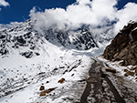 "+
"",
yumthangbengali : "ইউমথাং ভ্যালিঃ-সিকিমের উত্তরে ৩,৫৬৪ মিটার বা ১১,৭৬১ ফুট উঁচুতে অবস্থিত ইউমথাং উপত্যকা অত্যন্ত মনোরম ও সিকিমের সবচেয়ে বিখ্যাত পর্যটন গন্তব্যস্থলগুলোর মধ্যে একটা, যা ‘ফুলের উপত্যকা’ নামে পরিচিত। এই অবস্থানের ওপর দিকে কোনও গাছ জন্মায় না। উপত্যকার চারপাশে তুষার-ঢাকা পাহাড়ের সারি, নীচের ঢালে ঝোপঝাড়, ফুলের তৃণভূমিতে আচ্ছাদিত দীর্ঘ প্রসারিত জমি, এবং সুগন্ধি পরিবেশ, এই স্থানটাকে প্রকৃতির এক আশ্চর্যভূমি করে তুলেছে যা সারা দেশের বহু পর্যটককে আকর্ষণ করে। উপত্যকায় রয়েছে পানহুনরি এবং শুন্ডু সেনপার মতো সুন্দর পর্বতচূড়া ও তার ব্যাপ্তি, আর ফুলের উপত্যকার বুক চিরে কলকল শব্দে বয়ে চলা, স্ফটিক স্বচ্ছ তিস্তা নদীর প্রবাহের সমন্বয়ে তৈরি হয়েছে এক রূপসী পরিবেশ যা প্রত্যাখ্যান করা অত্যন্ত নিষ্ঠুর মানুষের পক্ষেও সম্ভব নয়। ইয়াকের চারণভূমিতে, হাজার হাজার জানা-অজানা ফুল হিমালয়ের কোলে নিশ্চিন্ত আশ্রয়ে ফুটে আছে, ও তাদের অভিভাবকের মতো রয়েছে নানা রঙের রডোডেনড্রন ফুলের বিস্ময়কর সংগ্রহ যা পর্যটকদের আরও কিছুক্ষণ থাকার জন্য প্রলুব্ধ করে।ইউমথাং উপত্যকায় ইয়াকের পিঠে চেপে ভ্রমণ এক অন্য মাত্রার আনন্দ। আবহাওয়া সাথ দিলে এই আনন্দ অধিরোহণ কেউ হারাতে চায় না। কাছেই রয়েছে দুটো সুন্দর নদী ইউমথাং চু এবং পুনিয়া চু। মাত্র সাত আট কিলোমিটার দূরে গেলেই পাওয়া যাবে ৩৫ বর্গ কিলোমিটারের শিংবা রডোডেনড্রন অভয়ারণ্য, যেখানে রয়েছে ৩৮ রকমেরও বেশি অত্যন্ত চিত্তাকর্ষক রডোডেনড্রন ফুলের সংগ্রহ। উপত্যকায় যাওয়ার পথে রয়েছে একটা ছোট্ট সেতু যা দিয়ে ইউমথাং গরম জলের কুণ্ডে পৌঁছনো যায়। এই জায়গাটার বিশেষত্ব হলো খুব ঠাণ্ডা আবহাওয়াতেও এখান দিয়ে প্রবাহিত জল উষ্ণ থাকে। এই জলে প্রচুর পরিমাণে গন্ধক থাকায়, এটা বিভিন্ন অসুখে নিরাময়ের ওষুধ বলে বিশ্বাস করা হয়। উষ্ণ প্রস্রবণের উত্তরে প্রায় সাত কিলোমিটার দূরে, একটা বিখ্যাত শিব মন্দির রয়েছে। ইউমথাং উপত্যকা থেকে প্রায় ২৫ কিলোমিটার দূরে, ১৫,০০০ ফুটেরও বেশি উচ্চতায়, চীন সীমান্তের খুব কাছে রয়েছে, খুবই জনপ্রিয় গন্তব্যস্থল জিরো পয়েন্ট বা ইউম স্যামডং। এখানে রয়েছে প্রাকৃতিক দৃশ্যের মনোমুগ্ধকর চারুত্ব এবং তুষারাবৃত পর্বতচূড়ার অনিরুদ্ধ পটভূমি। মাত্রাহীন সৌন্দর্যের এক মূর্ত প্রতীক এই জিরো পয়েন্ট। পর্যটকরা বরফ নিয়ে খেলা করে, ছবি তোলে, ও প্রকৃতির অসীম আর্শীবাদ পরখ করে। বাঁদিকে রয়েছে ডংকিলা ও ডানদিকে রয়েছে খারগুলা পর্বতশৃঙ্গ। এগুলো তিব্বতে অবস্থিত হলেও এর দৃশ্য অত্যন্ত মনোরম।কাঞ্চনজঙ্ঘার ৭৫ কিলোমিটার উত্তর-পূর্বে পাউহুনরি রেঞ্জ থেকে একটা বৃহৎ এলাকা বেরিয়ে নিম্ন হিমালয়ে প্রায় পঞ্চাশ কিলোমিটার পর্যন্ত দক্ষিণ ডংকিয়া রেঞ্জ তৈরি করেছে। এটা লাচুং নদীর উপত্যকা থেকে ভেঙ্গে, সেন গুই কাং পর্বতশৃঙ্গ থেকে বিচ্ছিন্ন হয়েছে, এবং ৪,৪৩৫ মিটার উচ্চতার চো লা এর ঠিক উত্তরে, চো লা রেঞ্জের উপর হেলে পড়েছে। চো লা এর কাছে উৎপন্ন হয়েছে রাতে চু নদী, যা উত্তর এবং পূর্ব সিকিমের মধ্যে একটা বিভাজন রেখা তৈরি করেছে, ও শেষ পর্যন্ত ডিকচুর কাছে তিস্তা নদীতে গিয়ে মিশেছে। চো লা রেঞ্জ পূর্ব সিকিমের পূর্ব সীমানা বরাবর আরও দক্ষিণে কুড়ি কিলোমিটার পর্যন্ত বিস্তৃত হয়েছে, ও তিব্বতের আম্মো চু জেলায় রংপো-দে চু উপত্যকায় এক জলবিভাজিকা সৃষ্টি করেছে। অঞ্চলের দক্ষিণ-পূর্ব অংশে রংপো-দে চু একটা সরু উপত্যকা তৈরি করেছে, ও চো লা রেঞ্জের শেষ প্রান্তকে গভীরভাবে বিভক্ত করে, শেষ পর্যন্ত দার্জিলিং জেলা এবং ভুটানের মধ্যে সীমানা চিহ্নিত করেছে, ও একটা গিরিসঙ্কটের মাধ্যমে দক্ষিণ দিকে প্রবাহিত হয়েছে। সিকিমের সঙ্গে তিব্বতের সীমানা, পশ্চিমে গ্রেট হিমালয় রেঞ্জের উত্তর-দক্ষিণ শাখা দ্বারা আবদ্ধ, যা বিশ্বের তৃতীয় সর্বোচ্চ শৃঙ্গ কাঞ্চনজঙ্ঘা, এবং এর দক্ষিণে সিঙ্গালিলা পর্বতমালা রয়েছে। উত্তরে ডংকিয়া রেঞ্জ দ্বারা আবদ্ধ, এবং আংশিকভাবে তিব্বতীয় মালভূমিও রয়েছে। আসলে তিব্বতের সঙ্গে ভারতের সীমানা প্রায় চার হাজার কিলোমিটারের যা, পূর্ব লাদাখ থেকে শুরু করে অরুণাচল প্রদেশের পূর্ব প্রান্ত ইটানগর অব্দি বিস্তৃত। চীন অধিকৃত তিব্বতের জন্যেই এই পুরো এলাকাটায় মিলিটারি ক্যাম্প রয়েছে ও অসামরিক মানুষজনের জন্যে রয়েছে অনেক বিধিনিষেধ।অঞ্চলটা দেখার সর্বোত্তম সময় অবশ্যই গ্রীষ্মকালে, এপ্রিল এবং মে মাসের মধ্যে। কারণ এর উচ্চতা বেশি না হলেও তিব্বতের রুক্ষ মালভূমির খুব কাছে থাকার কারণে, এখানে প্রচুর তুষারপাত হয়। আবহাওয়া একটু খারাপ হলেই এখানে তুষারপাত হয়, ও এই এলাকা ঘোরা প্রায় অসম্ভব হয়ে যায়। আবার শীতকালে প্রবল তুষারপাত ও অসহনীয় ঠান্ডার ফলে এই জায়গায় পৌঁছানোই বিপজ্জনক হয়ে যায়। বর্ষার ক্ষেত্রেও প্রায় একই অবস্থা।ইউমথাং উপত্যকা গ্যাংটক থেকে ১৪০ কিলোমিটার দূরে অবস্থিত। সাধারণত পর্যটকরা গুরদোংমার লেক ও ইউমথাং ভ্যালি একই ট্যুরে ঘুরে থাকেন। কারণ এখানে সম্ভবত জিরোর পর ইনার লাইন পারমিট লাগে। তাই পর্যটকরা একই পারমিটে দুদিন বা তিনদিনে গুরদোংমার লেক ও ইউমথাং ভ্যালি দেখে নেন। এখানে আসতে হলে, সরকার স্বীকৃত ১৪৪টা ট্র্যাভেল এজেন্টের মধ্যে, কোনও এক ট্র্যাভেল এজেন্টের সঙ্গে আসতে হবে। নিজের গাড়ি বা নিজের প্রোগ্রাম এখানে চলতে পারে, তবে তা সবই ট্র্যাভেল এজেন্টের মাধ্যমে ও শর্তে করতে হবে। এখানকার গাড়ির ড্রাইভাররা ট্যুর সংক্রান্ত প্রত্যেক বিষয়ে বিশেষভাবে ওয়াকিবহাল, ফলে ট্যুর অপারেটররা ড্রাইভারদের ওপর পুরোপুরি নির্ভরশীল। এখানে আসতে হলে লাচুং-এ এক রাত থাকা জরুরি। কারণ পুলিশ চেকপোষ্ট খোলে সকাল ছটার পরে ও তা বেলা বারোটার পর বন্ধ হয়ে যায়। লাচুংও প্রকৃতি সৃষ্ট এক অনবদ্য রূপসী অবস্থান। প্রচুর হোটেল থাকলেও পুরো এলাকাটা পরিষ্কার পরিচ্ছন্ন ও প্রাকৃতিক পরিবেশের ঘেরাটোপে রয়েছে। এখান থেকে দেখা যায় বরফের টোপর পরা নিকটবর্তী পাহাড়ের সৌন্দর্য, ঝরণা, ও ঘন সবুজ আদিম জঙ্গলের এক অনবদ্য স্বাদ। কাছেই রয়েছে সর্পিল আকারে বয়ে চলা কাকচক্ষু নীলাভ জলের নদী লাচুং, যা তিস্তার একটা অন্যতম শাখানদী। বিভিন্ন ধরণের ফুল, গাছ, জরিবুটি ও ঝোপঝাড়ের সাথে এখানকার জঙ্গলে রয়েছে বিভিন্ন ধরণের জন্তু জানোয়ার। তবে জন্তু জানোয়ারের দেখা পাওয়া মুস্কিল হলেও ফুল, জঙ্গল, ও ঝোপঝাড়ের সাথে তুষারাবৃত পাহাড়ের সৌন্দর্য প্রত্যেক পর্যটককে মুগ্ধ করবেই তা একপ্রকার নিশ্চিত। "+
"Read More..."+ "
"+
"",
yumthangbengali : "ইউমথাং ভ্যালিঃ-সিকিমের উত্তরে ৩,৫৬৪ মিটার বা ১১,৭৬১ ফুট উঁচুতে অবস্থিত ইউমথাং উপত্যকা অত্যন্ত মনোরম ও সিকিমের সবচেয়ে বিখ্যাত পর্যটন গন্তব্যস্থলগুলোর মধ্যে একটা, যা ‘ফুলের উপত্যকা’ নামে পরিচিত। এই অবস্থানের ওপর দিকে কোনও গাছ জন্মায় না। উপত্যকার চারপাশে তুষার-ঢাকা পাহাড়ের সারি, নীচের ঢালে ঝোপঝাড়, ফুলের তৃণভূমিতে আচ্ছাদিত দীর্ঘ প্রসারিত জমি, এবং সুগন্ধি পরিবেশ, এই স্থানটাকে প্রকৃতির এক আশ্চর্যভূমি করে তুলেছে যা সারা দেশের বহু পর্যটককে আকর্ষণ করে। উপত্যকায় রয়েছে পানহুনরি এবং শুন্ডু সেনপার মতো সুন্দর পর্বতচূড়া ও তার ব্যাপ্তি, আর ফুলের উপত্যকার বুক চিরে কলকল শব্দে বয়ে চলা, স্ফটিক স্বচ্ছ তিস্তা নদীর প্রবাহের সমন্বয়ে তৈরি হয়েছে এক রূপসী পরিবেশ যা প্রত্যাখ্যান করা অত্যন্ত নিষ্ঠুর মানুষের পক্ষেও সম্ভব নয়। ইয়াকের চারণভূমিতে, হাজার হাজার জানা-অজানা ফুল হিমালয়ের কোলে নিশ্চিন্ত আশ্রয়ে ফুটে আছে, ও তাদের অভিভাবকের মতো রয়েছে নানা রঙের রডোডেনড্রন ফুলের বিস্ময়কর সংগ্রহ যা পর্যটকদের আরও কিছুক্ষণ থাকার জন্য প্রলুব্ধ করে।ইউমথাং উপত্যকায় ইয়াকের পিঠে চেপে ভ্রমণ এক অন্য মাত্রার আনন্দ। আবহাওয়া সাথ দিলে এই আনন্দ অধিরোহণ কেউ হারাতে চায় না। কাছেই রয়েছে দুটো সুন্দর নদী ইউমথাং চু এবং পুনিয়া চু। মাত্র সাত আট কিলোমিটার দূরে গেলেই পাওয়া যাবে ৩৫ বর্গ কিলোমিটারের শিংবা রডোডেনড্রন অভয়ারণ্য, যেখানে রয়েছে ৩৮ রকমেরও বেশি অত্যন্ত চিত্তাকর্ষক রডোডেনড্রন ফুলের সংগ্রহ। উপত্যকায় যাওয়ার পথে রয়েছে একটা ছোট্ট সেতু যা দিয়ে ইউমথাং গরম জলের কুণ্ডে পৌঁছনো যায়। এই জায়গাটার বিশেষত্ব হলো খুব ঠাণ্ডা আবহাওয়াতেও এখান দিয়ে প্রবাহিত জল উষ্ণ থাকে। এই জলে প্রচুর পরিমাণে গন্ধক থাকায়, এটা বিভিন্ন অসুখে নিরাময়ের ওষুধ বলে বিশ্বাস করা হয়। উষ্ণ প্রস্রবণের উত্তরে প্রায় সাত কিলোমিটার দূরে, একটা বিখ্যাত শিব মন্দির রয়েছে। ইউমথাং উপত্যকা থেকে প্রায় ২৫ কিলোমিটার দূরে, ১৫,০০০ ফুটেরও বেশি উচ্চতায়, চীন সীমান্তের খুব কাছে রয়েছে, খুবই জনপ্রিয় গন্তব্যস্থল জিরো পয়েন্ট বা ইউম স্যামডং। এখানে রয়েছে প্রাকৃতিক দৃশ্যের মনোমুগ্ধকর চারুত্ব এবং তুষারাবৃত পর্বতচূড়ার অনিরুদ্ধ পটভূমি। মাত্রাহীন সৌন্দর্যের এক মূর্ত প্রতীক এই জিরো পয়েন্ট। পর্যটকরা বরফ নিয়ে খেলা করে, ছবি তোলে, ও প্রকৃতির অসীম আর্শীবাদ পরখ করে। বাঁদিকে রয়েছে ডংকিলা ও ডানদিকে রয়েছে খারগুলা পর্বতশৃঙ্গ। এগুলো তিব্বতে অবস্থিত হলেও এর দৃশ্য অত্যন্ত মনোরম।কাঞ্চনজঙ্ঘার ৭৫ কিলোমিটার উত্তর-পূর্বে পাউহুনরি রেঞ্জ থেকে একটা বৃহৎ এলাকা বেরিয়ে নিম্ন হিমালয়ে প্রায় পঞ্চাশ কিলোমিটার পর্যন্ত দক্ষিণ ডংকিয়া রেঞ্জ তৈরি করেছে। এটা লাচুং নদীর উপত্যকা থেকে ভেঙ্গে, সেন গুই কাং পর্বতশৃঙ্গ থেকে বিচ্ছিন্ন হয়েছে, এবং ৪,৪৩৫ মিটার উচ্চতার চো লা এর ঠিক উত্তরে, চো লা রেঞ্জের উপর হেলে পড়েছে। চো লা এর কাছে উৎপন্ন হয়েছে রাতে চু নদী, যা উত্তর এবং পূর্ব সিকিমের মধ্যে একটা বিভাজন রেখা তৈরি করেছে, ও শেষ পর্যন্ত ডিকচুর কাছে তিস্তা নদীতে গিয়ে মিশেছে। চো লা রেঞ্জ পূর্ব সিকিমের পূর্ব সীমানা বরাবর আরও দক্ষিণে কুড়ি কিলোমিটার পর্যন্ত বিস্তৃত হয়েছে, ও তিব্বতের আম্মো চু জেলায় রংপো-দে চু উপত্যকায় এক জলবিভাজিকা সৃষ্টি করেছে। অঞ্চলের দক্ষিণ-পূর্ব অংশে রংপো-দে চু একটা সরু উপত্যকা তৈরি করেছে, ও চো লা রেঞ্জের শেষ প্রান্তকে গভীরভাবে বিভক্ত করে, শেষ পর্যন্ত দার্জিলিং জেলা এবং ভুটানের মধ্যে সীমানা চিহ্নিত করেছে, ও একটা গিরিসঙ্কটের মাধ্যমে দক্ষিণ দিকে প্রবাহিত হয়েছে। সিকিমের সঙ্গে তিব্বতের সীমানা, পশ্চিমে গ্রেট হিমালয় রেঞ্জের উত্তর-দক্ষিণ শাখা দ্বারা আবদ্ধ, যা বিশ্বের তৃতীয় সর্বোচ্চ শৃঙ্গ কাঞ্চনজঙ্ঘা, এবং এর দক্ষিণে সিঙ্গালিলা পর্বতমালা রয়েছে। উত্তরে ডংকিয়া রেঞ্জ দ্বারা আবদ্ধ, এবং আংশিকভাবে তিব্বতীয় মালভূমিও রয়েছে। আসলে তিব্বতের সঙ্গে ভারতের সীমানা প্রায় চার হাজার কিলোমিটারের যা, পূর্ব লাদাখ থেকে শুরু করে অরুণাচল প্রদেশের পূর্ব প্রান্ত ইটানগর অব্দি বিস্তৃত। চীন অধিকৃত তিব্বতের জন্যেই এই পুরো এলাকাটায় মিলিটারি ক্যাম্প রয়েছে ও অসামরিক মানুষজনের জন্যে রয়েছে অনেক বিধিনিষেধ।অঞ্চলটা দেখার সর্বোত্তম সময় অবশ্যই গ্রীষ্মকালে, এপ্রিল এবং মে মাসের মধ্যে। কারণ এর উচ্চতা বেশি না হলেও তিব্বতের রুক্ষ মালভূমির খুব কাছে থাকার কারণে, এখানে প্রচুর তুষারপাত হয়। আবহাওয়া একটু খারাপ হলেই এখানে তুষারপাত হয়, ও এই এলাকা ঘোরা প্রায় অসম্ভব হয়ে যায়। আবার শীতকালে প্রবল তুষারপাত ও অসহনীয় ঠান্ডার ফলে এই জায়গায় পৌঁছানোই বিপজ্জনক হয়ে যায়। বর্ষার ক্ষেত্রেও প্রায় একই অবস্থা।ইউমথাং উপত্যকা গ্যাংটক থেকে ১৪০ কিলোমিটার দূরে অবস্থিত। সাধারণত পর্যটকরা গুরদোংমার লেক ও ইউমথাং ভ্যালি একই ট্যুরে ঘুরে থাকেন। কারণ এখানে সম্ভবত জিরোর পর ইনার লাইন পারমিট লাগে। তাই পর্যটকরা একই পারমিটে দুদিন বা তিনদিনে গুরদোংমার লেক ও ইউমথাং ভ্যালি দেখে নেন। এখানে আসতে হলে, সরকার স্বীকৃত ১৪৪টা ট্র্যাভেল এজেন্টের মধ্যে, কোনও এক ট্র্যাভেল এজেন্টের সঙ্গে আসতে হবে। নিজের গাড়ি বা নিজের প্রোগ্রাম এখানে চলতে পারে, তবে তা সবই ট্র্যাভেল এজেন্টের মাধ্যমে ও শর্তে করতে হবে। এখানকার গাড়ির ড্রাইভাররা ট্যুর সংক্রান্ত প্রত্যেক বিষয়ে বিশেষভাবে ওয়াকিবহাল, ফলে ট্যুর অপারেটররা ড্রাইভারদের ওপর পুরোপুরি নির্ভরশীল। এখানে আসতে হলে লাচুং-এ এক রাত থাকা জরুরি। কারণ পুলিশ চেকপোষ্ট খোলে সকাল ছটার পরে ও তা বেলা বারোটার পর বন্ধ হয়ে যায়। লাচুংও প্রকৃতি সৃষ্ট এক অনবদ্য রূপসী অবস্থান। প্রচুর হোটেল থাকলেও পুরো এলাকাটা পরিষ্কার পরিচ্ছন্ন ও প্রাকৃতিক পরিবেশের ঘেরাটোপে রয়েছে। এখান থেকে দেখা যায় বরফের টোপর পরা নিকটবর্তী পাহাড়ের সৌন্দর্য, ঝরণা, ও ঘন সবুজ আদিম জঙ্গলের এক অনবদ্য স্বাদ। কাছেই রয়েছে সর্পিল আকারে বয়ে চলা কাকচক্ষু নীলাভ জলের নদী লাচুং, যা তিস্তার একটা অন্যতম শাখানদী। বিভিন্ন ধরণের ফুল, গাছ, জরিবুটি ও ঝোপঝাড়ের সাথে এখানকার জঙ্গলে রয়েছে বিভিন্ন ধরণের জন্তু জানোয়ার। তবে জন্তু জানোয়ারের দেখা পাওয়া মুস্কিল হলেও ফুল, জঙ্গল, ও ঝোপঝাড়ের সাথে তুষারাবৃত পাহাড়ের সৌন্দর্য প্রত্যেক পর্যটককে মুগ্ধ করবেই তা একপ্রকার নিশ্চিত। "+
"Read More..."+ " "+
"
"+
" "+
"
"+
" "+
"
"+
" "+
"
"+
" "+
"
"+
" "+
"
"+
" "+
"
"+
" "+
"",
headingbengali : "সিকিম",
headingenglish : "SIKKIM",
};
"+
"",
headingbengali : "সিকিম",
headingenglish : "SIKKIM",
};