var Ladakhplaces =
{
menusystembengali :
" "+
"এই পাতার জায়গাসমূহঃ-"+
"মেনু দেখতে ক্লিক করুন"+
" •লাদাখ"+
" •লে "+
" •লামায়ারু"+
" •নুব্রা-ভ্যালি "+
" •প্যাংগং-লেক"+
" •সো-কর-লেক"+
" •সো-মরিরি-লেক",
menusystemenglish :
" "+
"Places in This Page:-"+
"Click To See Menu"+
" •Ladakh"+
" •Leh "+
" •Lamayaru"+
" •Nubra-Valley "+
" •Pangong-Lake"+
" •Tsokar-Lake"+
" •Tsomoriri-Lake",
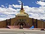
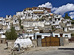
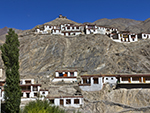
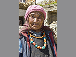
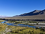
ladakhintrobengali : "লাদাখঃ-অনিন্দ্যসুন্দর খাঁজকাটা ঊষর পাহাড় দিয়ে আলিঙ্গনাবদ্ধ হয়ে থাকা পুরানো বৌদ্ধ রাজত্ব, ছবির মতো সুন্দর গুম্ফা, পাথরের মুকুট পরা চমকপ্রদ সাদা স্তূপা, দেওয়ালের মধ্যে সুন্দর সুন্দর অঙ্কনশিল্পের নাটকীয়তা, উড্ডীয়মান প্রার্থনা পতাকাগুলোর মৃদুমন্দ বাতাসের সাথে আধ্যাত্মিক বার্তার সমাপতন, ঘড়ির কাঁটার দিকে ঘূর্ণায়মান প্রার্থনা চাকার নতুন নতুন মন্ত্র তৈরি করা আর গুম্ফার অভ্যন্তরীণ মুরালগুলো অসংখ্য বোধিসত্ত্বের ভাস্কর্যের সাথে এমন রঙিন ভাবে জাগ্রত হয়ে আছে যে তা যে কোন পর্যটককে আকর্ষণ করবেই তা সে যত কঠিন মানুষই হোক না কেন।ইতিহাসঃ-লাদাখ বর্তমানে ভারতের একটা কেন্দ্র শাসিত অঞ্চল। এই অঞ্চলের উত্তরে কুনলুন পর্বতশ্রেণী এবং দক্ষিণে হিমালয় দ্বারা বেষ্টিত। ১৯৪৭ সাল থেকে এই অঞ্চল ভারত, পাকিস্তান এবং চীনের মধ্যে বিরোধের বিষয় হয়ে দাঁড়িয়েছে। আগে তিব্বত একটা স্বায়ত্তশাসিত অঞ্চল ছিল। মানচিত্র অনুযায়ী লাদাখের দক্ষিণে হিমাচল প্রদেশ রাজ্য, পশ্চিমে জম্মু ও কাশ্মীর আর পশ্চিমে পাকিস্তান শাসিত গিলগিট-বালটিস্তান এবং চীনের জিনজিয়াংয় প্রদেশের দক্ষিণপশ্চিম কোণটা সীমাবদ্ধ রয়েছে সুদূর উত্তরে কারাকোরাম পাস পর্যন্ত। এটা কারাকোরাম পরিসরের সিয়াচেন হিমবাহ থেকে উত্তরে মূল গ্রেট হিমালয় পর্যন্ত বিস্তৃত। এর মধ্যে সিয়াচেন হিমবাহের উত্তরে সাক্সগাম উপত্যকাও ভারতের অংশ, তবে চীনের মদতে এই এলাকা শাসন করে পাকিস্তান, ঠিক যেমন আকসাই চীনের মতো বিশাল ভারতীয় এলাকা চীনের দখলে। এই এলাকার অধিবাসীরা ইন্দোআর্য এবং তিব্বতি বংশোদ্ভূত। লাদাখ ভারতের জনবিরল এলাকাগুলোর অন্যতম। ঐতিহাসিককাল ধরে বালটিস্তান উপত্যকা, সিন্ধু নদ উপত্যকা, জাঁস্কার, লাহুলস্পিতি সহ আকসাই চিন এবং নুব্রা উপত্যকা লাদাখের অংশ ছিল। বর্তমানে লাদাখ শুধুমাত্র লে জেলা ও কার্গিল জেলা নিয়ে গঠিত। তিব্বতি সংস্কৃতি দ্বারা লাদাখ প্রচণ্ডভাবে প্রভাবিত বলে এই অঞ্চলকে ক্ষুদ্র তিব্বতও বলা হয়ে থাকে। লাদাখে বৌদ্ধ ও মুসলিম ধর্মাবলম্বীর সংখ্যা প্রায় সমান সমান। পূর্বাঞ্চলে বৌদ্ধরা সংখ্যাগরিষ্ঠ এবং উত্তর ও পশ্চিমে মুসলিমরা সংখ্যাগরিষ্ঠ। পর্যটকদের পূর্বাঞ্চলের দিকে বেশি ঝোঁক পরিলক্ষিত হয়, কেননা এই অঞ্চলে বৌদ্ধদের নিদর্শন বেশি রয়েছে এবং সেগুলো সরাসরি তিব্বতি বৌদ্ধ সংস্কৃতির সাথে সম্পর্কিত। ১৯৪৭ সালে ভারত স্বাধীন হলে, কাশ্মীরের ডোগরা শাসক হরি সিং অন্তর্ভুক্তি চুক্তিতে সই করে, লাদাখ সহ সমগ্র কাশ্মীর রাজ্যকে ভারতের অন্তর্ভুক্ত করেন। এই সময় পাকিস্তানি সেনাবাহিনী, কাশ্মীর উপত্যকা, স্কার্দু ও জাঁস্কারের পাদুম এলাকা দখল করে লে অভিমুখে যাত্রা করলে ভারত-পাকিস্তান যুদ্ধ শুরু হয় ও ভারতীয় সেনাবাহিনী পুরো এলাকা দখলমুক্ত করে। ১৯৪৯ সালের জানুয়ারি মাসে ভারত ও পাকিস্তানের মধ্যে যুদ্ধবিরতি ঘোষিত হয় ও একীকৃত লাদাখ ও বালটিস্তান রাজনৈতিক ভাবে বিচ্ছিন্ন হয়ে পড়ে। ১৯৪৯ সালে চীন জিনজিয়াং ও নুব্রা উপত্যকার মধ্যে সীমান্ত বন্ধ করে দেয়। ১৯৫৫ সালে চীন, ভারতীয় ভূখণ্ড আকসাই চিনের ভেতর দিয়ে, জিনজিয়াং ও তিব্বতের মধ্যে সড়ক ও পাকিস্তানের সঙ্গে কারাকোরাম মহাসড়ক নির্মাণ করলে সীমান্তে উত্তেজনার সৃষ্টি হয়। ১৯৬২ সালে যুদ্ধের মাধ্যমে লাদাখের আকসাই চিন ও পার্শ্ববর্তী এলাকা চীন নিজের অন্তর্ভুক্ত করে নেয়। সামরিক কৌশলগত কারণে ভারত, শ্রীনগর থেকে লে পর্যন্ত একটা জাতীয় সড়ক তৈরি করে। ১৯৯৯ সালে পাকিস্তান লাদাখের পশ্চিমাংশের কার্গিল অঞ্চল নিজেদের দখলে নেওয়ার চেষ্টা করলে ভারত ও পাকিস্তানের মধ্যে আবার যুদ্ধ হয় ও কার্গিল দখলমুক্ত হয়। জম্মু ও কাশ্মীর রাজ্যের সঙ্গে লাদাখের অভ্যন্তরীণ প্রশাসনিক সম্পর্ক কখনই ভাল ছিল না। ১৯৭০ এর দশক থেকে এই অঞ্চলের মানুষেরা কেন্দ্রশাসিত অঞ্চলের মর্যাদার দাবি জানিয়ে এসেছে। ১৯৮৯ সালে লাদাখে বসবাসকারী বৌদ্ধ ও মুসলমান সম্প্রদায়ের মধ্যে হিংসাত্মক দাঙ্গা সৃষ্টি হলে বৌদ্ধরা মুসলিম প্রধান জম্মু ও কাশ্মীর রাজ্যের মুসলমানদের প্রতি পক্ষপাতিত্বের অভিযোগে, লাদাখে বসবাসকারী মুসলিম ব্যবসায়ীদের সাথে ব্যবসা বন্ধ করে দেয়। ১৯৯৫ সালে লাদাখ স্বায়ত্তশাসিত পার্বত্য উন্নয়ন পরিষদ, লে তৈরি হলে এই ক্ষোভ বহুলাংশে প্রশমিত হয়। তবে জাতীয় স্তরে গুরুত্ব লাভের আশায় লাদাখের প্রভাবশালী বৌদ্ধরা বর্তমানে ভারতীয় জনতা পার্টিকে সমর্থন করে। "+
"Read More..."+
"
"+
"শব্দঃ প্রতিবেদনঃ "+
""+
"ভিডিও"+
"স্লাইডশোর জন্যে নীচের ছবিতে ক্লিক করুন "+
"
"+
"পেজ মেনুতে যান",
ladakhintroenglish : "Ladakh:-The old Buddhist kingdom embraced by the immaculate notched barren hills, the picturesque caves, the dazzling white stupas crowned with stone crowns, the dramatic beauty of the beautiful paintings on the walls, The murals created and the interior of the cave are so colorful with the innumerable Bodhisattva sculptures that it will attract any tourist no matter how hard he tries. History:-Ladakh is now a Union Territory of India. The region is bounded on the north by the Kunlun Range and on the south by the Himalayas. The region has been a point of contention between India, Pakistan and China since 1947. Formerly Tibet was an autonomous region. According to the map, the state of Himachal Pradesh is bounded on the south by Ladakh, on the west by Jammu and Kashmir, on the west by Gilgit-Baltistan and the southwest corner of the Chinese province of Xinjiang is bounded on the far north by Karakoram Pass. It extends from the Siachen Glacier in the Karakoram Range to the main Great Himalayas in the north. The Saxgam Valley, north of the Siachen Glacier, is also part of India, but is ruled by Pakistan under Chinese influence, just as much of the Indian territory as Aksai Chin is occupied by China. The inhabitants of this area are of Indo-Aryan and Tibetan descent. Ladakh is one of the sparsely populated areas of India. Historically, Baltistan Valley, Indus River Valley, Zanskar, Lahulspiti, Aksai Chin and Nubra Valley were part of Ladakh. At present Ladakh consists only of Leh district and Kargil district. The region is also called Little Tibet because of its strong influence on Tibetan culture. The number of Buddhists and Muslims in Ladakh is almost equal. Buddhists are in the majority in the east and Muslims in the north and west. Tourists are more inclined towards the east, as there are more Buddhist monuments in the area and they are directly related to the Tibetan Buddhist culture. When India became independent in 1947, Hari Singh, the Dogra ruler of Kashmir, signed a treaty of annexation, annexing the entire state of Kashmir, including Ladakh, to India. At this time, the Indo-Pakistani war broke out when the Pakistani army marched towards Leh, occupying the Padum area of Kashmir Valley, Skardu and Zanskar, and the Indian army liberated the entire area. A ceasefire was declared between India and Pakistan in January 1949, and the unified Ladakh and Baltistan became politically isolated. In 1949, China closed the border between the Xinjiang and Nubra valleys. Tensions along the border erupted in 1955 when China built roads between Indian territory Aksai Chin, roads between Xinjiang and Tibet, and the Karakoram Highway with Pakistan. Through the war in 1962, Aksai Chin and the surrounding area of Ladakh were annexed by China. For military strategic reasons, India built a national road from Srinagar to Leh. When Pakistan tried to occupy the Kargil region west of Ladakh in 1999, war broke out again between India and Pakistan and Kargil was liberated. Ladakh's internal administrative relations with the states of Jammu and Kashmir have never been good. The people of this region have been demanding the status of a Union Territory since the 1980s. When violent riots broke out between the Buddhist and Muslim communities in Ladakh in 1989, Buddhists stopped doing business with Muslim traders in Ladakh, accusing them of favoring Muslims in the Muslim-majority state of Jammu and Kashmir. When the Ladakh Autonomous Hill Development Council, Leh, was formed in 1995, this anger was largely alleviated. However, influential Buddhists in Ladakh now support the Bharatiya Janata Party in the hope of gaining national prominence. "+
"Read More..."+
"
"+
"Sound Stream: "+
""+
"Video"+
"Click any Picture for Slide Show "+
"
"+
"Go To Page Menu",
photoladakhintro :
""+
" "+
" "+
" "+
" "+
" "+
" "+
" "+
" "+
"",
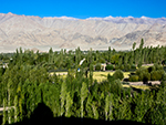
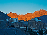
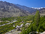
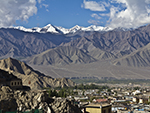
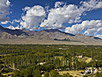
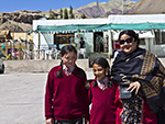
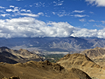
lehbengali : "লেঃ-মন্ত্রমুগ্ধ পর্বতমালার বন্ধনীতে আটকে থাকা লে শহরে রয়েছে ভ্রমণ বান্ধব পরিবেশ, মনোরম পারিপার্শ্বিকতা, সমস্যাবিহীন যানবাহন ও সুন্দর সুন্দর খাবারের সম্ভার, যা ভারতবর্ষের খুব কম শহরে পাওয়া যায়। ছোট ছোট বিন্দুর আকারে পাহাড়ে ফুটে থাকা স্তূপা, ছড়িয়ে ছিটিয়ে থাকা ছোট ছোট বাড়িঘর, ছুরির তীক্ষ্ণতার মতো খাড়া পাহাড়ের মাথায় অনিন্দ্যসুন্দর তিব্বতি শৈলীতে তৈরি বহু পুরানো রাজপ্রাসাদ ও কেল্লা, আজও পুরানো লে শহরে প্রভুত্ব করে। পাহাড়ের নীচে সুন্দর সাজানো গোছানো বাজার, একটার পর একটা ব্যস্ত ট্র্যাভেল এজেন্সির অফিস, স্যুভেনিরের দোকান, তন্দুরিপিৎজা ও ভারতীয় খাবারের রেস্তোরা থাকা সত্যেও, এখানেই রয়েছে একটা রোপণ করা সবুজ জঙ্গলের ঘেরাটোপ, যার অন্তরীক্ষ পর্যবেক্ষণ একটা মনোহারিণী প্রাকৃতিক নাট্যমঞ্চ। তীব্র গতির প্রবাহিণী, পাহাড়ের বুকে খেয়ালী শিল্পীর তুলিতে আঁকা সর্পিল রাস্তা ও তার সাথে বিরাম চিহ্নের মতো ঐতিহ্যবাহী শৈলীতে তৈরি লাদাখি বাড়িঘর ও হোমস্টে, এক মনোমুগ্ধকর পরিবেশ। এই লাদাখি বাড়িঘরগুলোর ছাদ সমতল, দেওয়াল শক্তপোক্ত ও প্রশস্ত, কাঠের জানলাদরজা আর বিভিন্ন রঙ ও অঙ্কনের চিত্রণে অলঙ্কৃত। এখানে থাকলে পাওয়া যাবে উষ্ণ অভ্যর্থনা, লাদাখিদের সমাজ জীবনের অনুভব ও সাবেকি লাদাখি খাবারের এক সুন্দর পরিবেশনা। লে এমন একটি জায়গা যার প্রেমে পড়তে সময় লাগে না। আর তাই মানুষ এই প্রেমের টানে বারবার ছুটে যায় বিভিন্ন সময়ে, বিভিন্ন ঋতুতে তার পরিবর্তনশীল রূপ অনুভব করতে। কথনও শ্বেতশুভ্র, কথনও ঊষর মরুভূমি, কখনও উপত্যকা জুড়ে রঙবেরঙের ঝরা পাতার কার্পেটের শান্ত পরিবেশ আবার কখনও প্রবহমান সিন্ধুনদের দুপাড়ে বৌদ্ধ অনুষ্ঠানের আমেজ। বলতেই হবে লাদাখ আমি তোমাকে ভালবাসি। "+
"Read More..."+
"
"+
"শব্দঃ প্রতিবেদনঃ "+
""+
"ভিডিও"+
"স্লাইডশোর জন্যে নীচের ছবিতে ক্লিক করুন "+
"
"+
"পেজ মেনুতে যান",
lehenglish : "Leh:-Nestled in the foothills of the Leh-enchanted mountains, Leh has a travel-friendly environment, pleasant surroundings, hassle-free vehicles and a wealth of delicious food, which is rarely found in any other city in India. Stupas in the form of small dots, small houses scattered, many old palaces and forts built in the impeccable Tibetan style on the top of a steep hill like the sharpness of a knife, still dominate the old town of Le. Despite the beautifully arranged market at the foot of the hill, one busy travel agency office after another, souvenir shops, tandoori pizza and Indian food restaurants, there is a planted green forest enclosure with a beautiful natural scenery overlooking the space. A charming atmosphere in Ladakhi homes and homestays, built in the traditional style of fast-moving streams, winding roads painted by whimsical artists on the hillside, and accompanying punctuation marks. The roofs of these Ladakhi houses are flat, the walls are sturdy and wide, the wooden windows and doors are decorated with various colors and drawings. If you stay here, you will find a warm welcome, a feeling of Ladakhi social life and a beautiful serving of old Ladakhi food. Le is a place that doesn't take long to fall in love. And so people rush to this love again and again at different times, in different seasons to feel it’s changing form. Kathan is white, Kathan is a barren desert, sometimes the serene atmosphere of colorful fallen carpet across the valley and sometimes the aura of Buddhist rituals on the banks of the flowing Indus. I have to say Ladakh, I love you. "+
"Read More..."+
"
"+
"Sound Stream: "+
""+
"Video"+
"Click any Picture for Slide Show "+
"
"+
"Go To Page Menu",
photoleh :
""+
" "+
" "+
" "+
" "+
" "+
" "+
" "+
" "+
"",
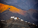
lamayurubengali : "লামায়ারুঃ-লাদাখের পশ্চিমাঞ্চলে, লে শহর থেকে প্রায় ১২৭ কিলোমিটার দূরে অবস্থিত, পর্বতযুক্ত অনুর্বর এলাকার মধ্যে অবস্থিত লামায়ারু একটা অন্যতম জনপ্রিয় গ্রাম আর কার্গিল-লে রুটের এক আদর্শ বিরতিস্থান। এখানকার লামায়ারু বৌদ্ধ মঠ দেখার জন্যে পর্যটকরা আসেন ও অন্তত একদিন থেকে যান। একাদশ শতাব্দীতে লামায়ারু মনাস্ট্রি প্রতিষ্ঠা করেন মহাসিদ্ধাচার্য নরোপা। এই বৌদ্ধ মঠ প্রায় দেড় শতাধিক সন্ন্যাসীর সাধনাস্থল। এখানে রয়েছে একটা অত্যন্ত সমৃদ্ধশালী সংগ্রহশালা যা শিল্পকলা, প্রাচীরচিত্র, পটচিত্র, বিভিন্ন মূর্তি, কার্পেট এবং এগার মাথা ও একহাজার চোখযুক্ত চেনজিংয়ের এক চিত্তাকর্ষক মূর্তি। বৌদ্ধমঠ ছাড়াও লামায়ারু তার অপরূপ প্রাকৃতিক দৃশ্যের জন্য পর্যটকদের আকর্ষণ করে যা চাঁদের ঊষর অঞ্চলের সাথে বেশ সদৃশ। অঞ্চলটা দূরবর্তী ও কিছুটা বিচ্ছিন্ন এলাকা বলে এই জায়গাটা ফটোগ্রাফার এবং ট্রেকারদের একটা জনপ্রিয় প্রমোদভ্রমণ। লোককথা অনুযায়ী লামায়ারু মঠের ইতিহাস দশম শতাব্দীরও আগের, যখন ভারতীয় পণ্ডিত মহাসিদ্ধাচার্য নরোপা একটা হ্রদকে পুরোপুরি শুকিয়ে দিয়ে পুরো উপত্যকায় জলের ব্যবস্থা করেছিলেন। ঐ শুকনো এলাকায় তিনি লামায়ারু মঠের ভিত্তি প্রস্তর স্থাপন করেছিলেন। এখানকার প্রাচীনতম বৌদ্ধ মঠের নাম সেঙ্গ-গে-সাগাং ও তা মনাস্ট্রির দক্ষিণদিকে অবস্থিত। "+
"Read More..."+
"
"+
"শব্দঃ প্রতিবেদনঃ "+
""+
"ভিডিও"+
"স্লাইডশোর জন্যে নীচের ছবিতে ক্লিক করুন "+
"
"+
"পেজ মেনুতে যান",
lamayuruenglish : "Lamayaru:-Located in the western part of Ladakh, about 126 kilometers from the town of Leh, in a mountainous barren area, Lamayaru is one of the most popular villages and an ideal stop on the Kargil-Le route. Tourists come here to visit the Lamayaru Buddhist Monastery and stay for at least a day. Mahasiddhacharya Naropa founded the Lamayaru Monastery in the eleventh century. This Buddhist monastery is a place of worship for about one and a half hundred monks. There is a very rich collection of art, murals, paintings, various sculptures, carpets and an impressive statue of Changing with eleven heads and one thousand eyes. In addition to the Buddhist monastery, Lamayaru attracts tourists for its stunning scenery, which is very similar to the barren region of the moon. As the area is remote and somewhat isolated, it is a popular destination for photographers and trekkers. According to folklore, the history of the Lamayaru monastery dates back to the 10th century, when the Indian scholar Mahasiddhacharya Naropa dried up a lake and provided water to the entire valley. He laid the foundation stone of Lamayaru Monastery in that dry area. The oldest Buddhist monastery here is called Seng-gay-sagang and is located to the south of the monastery. "+
"Read More..."+
"
"+
"Sound Stream: "+
""+
"Video"+
"Click any Picture for Slide Show "+
"
"+
"Go To Page Menu",
photolamayuru :
""+
" "+
" "+
" "+
" "+
" "+
" "+
" "+
" "+
"",
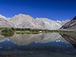
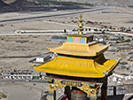
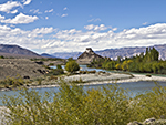
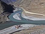
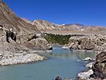
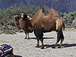
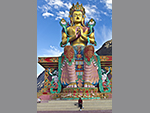
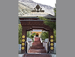
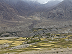
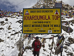
nubravalleybengali : "নুব্রা ভ্যালিঃ-শিয়ক ও নুব্রা নদীর উপত্যকা যেন খাড়া পাহাড়ের বুক চিরে বেরিয়ে এসে শ্রেষ্ঠত্বের আভিজাত্যে তৈরি করেছে এক বিস্ময়কর দৃশ্য, যেখানে রয়েছে মরূদ্যানের মতো পান্না সবুজ বৃক্ষরাজি সমৃদ্ধ গ্রাম, যার চতুর্দিক পরিবেষ্টন করে আছে নুড়ি পাথরের ঢাল, বড় বড় পাথরের চাঁইয়ের বিশাল বিস্তার, রূঢ় শুকনো ধূসর পাহাড় ও ঘন নীল পরিষ্কার আকাশ। রয়েছে পাহাড়ি বালিয়াড়ি, বৌদ্ধ মঠ, একটা ভাঙাচোরা প্রাসাদ আর তুরতুক ও বোগডাঙের একেবারে ভিন্ন সংস্কৃতি। নুব্রা ভ্যালি লাদাখের হৃদয় ও যে কোনও ভ্রমণার্থীর ভ্রমণসূচির অবশ্য উপাদান। লে শহর থেকে প্রায় ১২০ কি.মি. দূরে লাদাখের উত্তরপূর্বে অবস্থিত এই উপত্যকার প্রধান কার্যালয় ডিসকিট। শিয়ক নদী যা সিন্ধু নদের এক শাখানদী ও নুব্রা নদী বা সিয়াচেন নদী এখানেই মিলিত হয়ে তৈরি করেছে এক বিশাল উপত্যকা ও তা লাদাখ ও কারাকোরাম রেঞ্জকে আলাদা করে রেখেছে। এই দুটো নদীই সিয়েচেন হিমবাহের দু প্রান্ত থেকে উৎপন্ন হয়েছে। অতি বিস্তৃত দৃশ্যপট, বিশাল বিশাল পর্বতমালা, অতীব সুন্দর আঁকাবাঁকা পাহাড়ি রাস্তা, বৈচিত্র্যপূর্ণ রঙের মিলন আর উপত্যকার বুক চিরে বেরিয়ে আসা শিয়ক নদীর সুরেলা গীতিনাট্য, প্রথম দর্শনেই পর্যটকদের অনুরাগের কারণ হয়ে যাবে।তবে এমন সুন্দর স্থানে যাবার পথ পর্যটকদের জন্যে বছরের বেশিরভাগ সময়ই বন্ধ থাকে। কারণ লে থেকে নুব্রা ভ্যালি যেতে হলে পার করতে হবে পৃথিবীর সর্বোচ্চ গাড়ি চলার রাস্তা খারদুংলা পাস। খারদুংলা পাসের উচ্চতা ১৮,৩৮০ ফুট আর ভিউ পয়েন্টের উচ্চতা ১৭,৯৮২ ফুট। মে থেকে আগস্ট মাস পর্যন্ত এই রাস্তা পর্যটকদের জন্য খোলা থাকে। এখানে আসতে হলে অতি উচ্চতার আবহাওয়ার সঙ্গে খাপ খাইয়ে নেওয়ার জন্যে, লে শহর বা তার কাছাকাছি কোথাও দু তিন দিন কাটানো অবশ্যই প্রয়োজন। লে থেকে খারদুংলা পাসের দূরত্ব চল্লিশ কিলোমিটার। প্রথম কুড়ি কি.মি. রাস্তা ভাল হলেও বাকি পথ বন্ধুর। মাঝে মাঝেই ধস বা বরফের কারণে রাস্তা বন্ধ হয়ে যায় এবং বর্ডার রোড অর্গানাইজেশন দ্বারা রাস্তা পরিষ্কার করার পর আবার গাড়ি চলা শুরু হয়। খারদুংলা পাসের উত্তর ও দক্ষিণ দিকে দুটো চেকপোস্টের মাধ্যমে যানবাহন চলাচল নিয়ন্ত্রণ করা হয়। একে তো উচ্চতা তার ওপর বছরের বেশিরভাগ সময়ই খারদুংলার তাপমাত্রা খুব কম থাকে। তাই পর্যটকরা এখানে বেশিক্ষণ থাকেন না। শিয়ক নদীর তীর বরাবর গড়ে উঠেছে ডিসকিট ও হুন্ডার গ্রাম। আর নুব্রা নদীর তীরে গড়ে ওঠা গ্রামগুলো হল সুমুর, টিগ্গুর, পানামিক ইত্যাদি। লে শহর থেকে নুব্রা ভ্যালি পৌঁছতে সময় লাগে ৬-৭ ঘণ্টার মতো। কিন্তু খারাপ রাস্তা ও অন্যান্য কারণে বেশি সময়ও লেগে যায়। সিয়ক ও নুব্রা নদীর সঙ্গমস্থল থেকে খালসার থেকে বাঁদিকের রাস্তা ধরে ২২ কিলোমিটার দূরে ডিসকিট গ্রাম। নুব্রা উপত্যকার সবথেকে বড় গুম্ফা, ডিসকিট গ্রামের পাহাড়ের মাথায় অবস্থিত। খালসার থেকে ডিসকিটের রাস্তার সৌন্দর্য অপূর্ব। পান্না সবুজ উপত্যকার মধ্যে দিয়ে দুধসাদা সিয়ক নদী বয়ে চলেছে তার নিজস্ব খেয়ালে। দুরের পাহাড় কোথাও নীল, কোথাও ধুসর, কোথাও বা হলদে। প্রাচীনকালের সিল্করুটও এই উপত্যকা ধরেই তিব্বতে যেত। ডিসকিট গ্রাম হল নুব্রা ভ্যালির হেড কোয়ার্টার। ডিসকিটকে নুব্রা ভ্যালির চাষের বাগানও বলা হয়ে থাকে। কারণ এখানে সবচেয়ে বেশী চাষ হয়ে থাকে সর্ষে, মটরশুঁটি, বার্লি, অপ্রিকট, আমন্ড প্রভৃতি। ডিসকিট অঞ্চলে প্রবেশ করার সঙ্গে সঙ্গে একটা ছোট পাহাড়ের মাথায় বত্রিশ মিটার লম্বা বিখ্যাত মৈত্রেয়ী বৌদ্ধমূর্তি দেখতে পাওয়া যায়। পাহাড়ের পাদদেশ থেকে দশ মিনিটের গাড়ির ঘোরানো সুন্দর রাস্তায় উঠে যাওয়া যায় মূর্তির কাছে। রাস্তার চারদিকে রংবেরঙের প্রার্থনা পতাকা, সাদা চোর্তেন আর ডিসকিট গ্রামের দৃশ্য অপূর্ব সুন্দর লাগে। গাড়িতে না গিয়ে হেঁটেও ওঠা যায় তবে তা বেশ কষ্টকর, কিন্তু পাওনা হবে অনেকটাই বেশি। খোলা জায়গায় বিশাল রঙিন বৌদ্ধমূর্তি দাঁড়িয়ে আছে শিয়ক নদীর দিকে মুখ করে। পেছনে ধুসর পাহাড়। চাতাল থেকে হিমালয় রেঞ্জের দৃশ্য বড় মনোরম। ডিসকিটের আর এক দ্রষ্টব্য হল সাড়ে তিনশো বছরের পুরানো ডিসকিট মনাস্ট্রি আর লাচুং টেম্পল। কাছেই রয়েছে হুণ্ডার গ্রাম। এই গ্রামের পাশেই আছে লাদাখের অন্যতম প্রধান দ্রষ্টব্য শীতল মরুভূমি। এই মরুভূমির বালির রং সাদা। মরুভূমির মধ্যে আছে ঢেউ খেলানো বালিয়াড়ি আর তার বুকে চরে বেড়ায় লাদাখের বিখ্যাত দু কুঁজ বিশিষ্ট ব্যাকট্রিয়ান উট। এই উট ভারতে একমাত্র এই জায়গাতেই দেখা যায়। সম্ভবত মোঙ্গল আক্রমণকারীরা এই উটগুলো ভারতে নিয়ে এসেছিলেন। সাদা বরফে মোড়া সুউচ্চ শৃঙ্গ আর মরুভূমির বালিয়াড়িকে এক ফ্রেমে ধরা যায় এই হুণ্ডারেই। হুণ্ডারে একটা আর্মি মেডিক্যাল ক্যাম্প আছে। পর্যটকরা কোনও কারণে অসুস্থ বোধ করলে মিলিটারিরা খুব সহযোগিতা করেন। এখান থেকে সিয়েচেন গ্লেসিয়ারের দূরত্ব প্রায় ৯০ কি.মি.। আমরা সবাই জানি সিয়াচেন গ্লেসিয়ার পৃথিবীর সবথেকে উঁচু যুদ্ধক্ষেত্র। কিন্তু কেন ? কি কারণে যুদ্ধ ? হিমাঙ্কের ৫৫ ডিগ্রি নীচে তাপমাত্রা চলে যাওয়া সত্যেও সারা বছর ধরে মিলিটারি পোস্টিং রাখা হয় কেন ? নীচের লাইনগুলো বলে দেবে তার ইতিহাস।ইতিহাসঃ- সিয়াচেন দ্বন্দ্ব ভারত ও পাকিস্তানের মধ্যে কাশ্মীরের সিয়াচেন হিমবাহের অধিকারের জন্য সামরিক দ্বন্দ্ব। ১৯৮৪ সালে ভারতের সফল সামরিক অভিযান অপারেশন মেঘদূতের মাধ্যমে এই দ্বন্দ্বের সূত্রপাত হয়। সিয়াচেন হিমবাহ পৃথিবীর উচ্চতম যুদ্ধক্ষেত্র, যেখানে ভারত ও পাকিস্তান ১৯৮৪ সাল থেকে পরস্পরের বিরুদ্ধে লড়াই করে চলেছে। দু দেশই এই স্থানে ৬,০০০ মিটারের বেশি উচ্চতায় স্থায়ী সামরিক উপস্থিতি বজায় রেখেছে। এই দ্বন্দ্বের ফলে উভয় পক্ষের প্রায় ২০০০ মানুষ প্রচণ্ড শৈত্যে ও প্রাকৃতিক দুর্যোগের বলি হয়েছেন। ১৯৪৯ সালে ভারত, পাকিস্তান ও সম্মিলিত জাতিপুঞ্জের সামরিক পর্যবেক্ষক দল যুদ্ধবিরতি রেখা চুক্তিতে সই করে। ১৯৫৭ সালে পাকিস্তান, ব্রিটিশ পর্বতারোহী এরিক শিপটনের নেতৃত্বে বাইলাফন্ড গিরিবর্ত্ম হয়ে সিয়াচেন হিমবাহ অভিযানে সম্মতি প্রদান করে। পাঁচ বছর পরে এক জাপানী অভিযাত্রী দল সালতোরো কাংরি শৃঙ্গ অভিযান করেন। ১৯৬৩ সালে চিন, পাকিস্তানকে, ভারতীয় এলাকা সাক্সগাম উপত্যকা, প্রদান করার পর পাকিস্তান K-2 পর্বতশৃঙ্গে পশ্চিমী অভিযানে সম্মতি প্রদান করে। ১৯৬৭ সাল পর্যন্ত সম্মিলিত জাতিপুঞ্জ, পাকিস্তান ও অন্যান্যরা যুদ্ধবিরতি রেখা চুক্তি অনুযায়ী মানচিত্র প্রদর্শন করে। কিন্তু ১৯৬৭ সালেই ইউনাইটেড স্টেটস ডিফেন্স ম্যাপিং এজেন্সি, কোন রকম তথ্যসূত্র ছাড়াই তাদের মানচিত্রে কারাকোরাম গিরিবর্ত্মের পূর্ব ও দক্ষিণপূর্ব অঞ্চলকে চীনের অংশ হিসেবে বর্ণনা করে ও সিয়াচেন অঞ্চলকে পাকিস্তানের অংশ হিসাবে বর্ণনা করা হয়। ১৯৭১ সালে সিয়াচেন হিমবাহ অঞ্চলের সীমান্ত সংক্রান্ত সিমলা চুক্তিতে ভারতের অবস্থান অস্পষ্ট, এবং অসম্পূর্ণ ভাবে সংজ্ঞায়িত মার্কিন মানচিত্রের ওপর ভিত্তি করে পাকিস্তানের দাবীর কারণে এই দ্বন্দ্ব শুরু হয়। ফলে প্রায় এক দশক ধরে এই এলাকার বিভিন্ন পর্বতশৃঙ্গ, বাইলাফন্ড, সিয়াচেন ইত্যাদি হিমবাহে অভিযানের জন্যে পর্বতারোহীরা পাকিস্তানের কাছ থেকে অনুমতি নিতো। ভারতের মৌনতা বা গাফিলতি, পাকিস্তানকে এইসব অঞ্চলের মালিকানার দাবি জানাতে উৎসাহিত করে। পরবর্তীকালে ভারত সরকার ও সেনাবাহিনী সব কিছু লক্ষ্য করে মার্কিন মানচিত্রের ব্যাপারে প্রতিবাদ জানায়। মার্কিন মানচিত্রের প্রভাব ও পাকিস্তানের অনুমতিপত্রের গুরুত্ব অনুভব করে, ১৯৭৮ সালে ভারতীয় সেনাবাহিনীর হাই অল্টিচিউড ওয়ারফেয়ার স্কুল, সিয়াচেন অঞ্চলে টেরাম কাংরি-2 পর্বতশৃঙ্গে সেনা পর্বতারোহণ অভিযান করে। ইতিমধ্যে ভারতীয় গোয়েন্দা সংস্থা খবর পায় যে রাওয়ালপিন্ডির সামরিক ঘাঁটিতে পাকিস্তানের জেনারেলরা ভারতের আগেই সিয়াচেন দখল করার সিদ্ধান্ত নিয়েছেন। কিন্তু পাকিস্তানের সামরিক অভিযানের আগাম খবর পেয়ে ১৯৮৪ সালে ভারতীয় সেনাবাহিনী ও বিমানবাহিনী অপারেশন মেঘদূত শুরু করে। শীঘ্রই ভারত সিয়াচেন অঞ্চল নিজেদের অধিকারে নিয়ে নেয়। সিয়া ও বাইলাফন্ড গিরিবর্ত্ম ভারতের দখলে আসে। এর সাতদিন পরে পাকিস্তানি সেনাবাহিনী এই স্থানে পৌছলেও তাদের আগেই ভারতীয় সেনাবাহিনীর তিনশো সেনা পর্বতশীর্ষগুলো দখল করে নেয়। ১৯৮৪ সালের পর পাকিস্তান সিয়াচেন দখল নেওয়ার জন্যে বহুবার ব্যর্থ অভিযান করে। এর মধ্যে ১৯৮৭ সালের আক্রমণ ছিল সব চেয়ে উল্লেখযোগ্য। এই আক্রমণের নেতৃত্ব দেন জেনারেল পারভেজ মুশারফ। তিনি স্পেশাল সার্ভিসেস গ্রুপের একটা সদ্য তৈরি কমান্ডো দলের আট হাজার সৈন্যের এক বিশেষ গ্যারিসনকে বাইলাফন্ড গিরিবর্ত্ম দখলের জন্য পাঠান। কিন্তু অপারেশন রাজীব নামক তীব্র যুদ্ধের পর পাকিস্তানি সেনা পিছু হটতে বাধ্য হয়। সেই বছর পাকিস্তানের কায়েদ নামে একটা গুরুত্বপূর্ণ ঘাঁটি হাতছাড়া হয়। এই কাজটা করেন নায়েব সুবেদার বানা সিং, যিনি দিনের বেলায় ১,৫০০ ফুট খাড়া বরফের দেওয়াল ক্লাইম্ব করে ২২,১৪৩ ফুট উচ্চতায় অবস্থিত ঐ ঘাঁটি দখল করেন। তিনি ভারতের সর্বোচ্চ সাহসিকতার পুরস্কার পরমবীর চক্র লাভ করেন। এর পরেও পাকিস্তান অনেকবার সিয়াচেন দখলের জন্য আক্রমণ করে। ১৯৯৫ সালের আক্রমণে পাকিস্তানের স্পেশাল সার্ভিসেস গ্রুপের চল্লিশ জন সৈন্য নিহত হন।সিয়াচেন দ্বন্দ্বের ফলে ৯০০-১০০০ বর্গমাইল এলাকা ভারতের দখলে চলে আসে। ফলে ভারত ৭০ কি.মি. দীর্ঘ সিয়াচেন হিমবাহ ও তার সমস্ত প্রশাখা হিমবাহ এবং সিয়াচেন হিমবাহের পশ্চিমদিকে অবস্থিত সালতোরো পর্বতশ্রেণীর সিয়া, বাইলাফন্ড, ও গ্যোং এই তিনটে প্রধান গিরিবর্ত্ম নিজেদের দখলে আনে। অপরদিকে পাকিস্তান সালতোরো পর্বতশ্রেণীর পশ্চিমদিকে অবস্থিত হিমবাহ উপত্যকাগুলোকে অধিকার করে। বর্তমানে ২১,০০০ ফুট উচ্চতায় পয়েন্ট সোনমে বিশ্বের উচ্চতম হেলিপ্যাড স্থাপিত হয়েছে। সাথে মিলিটারিদের পরিবারের সাথে যোগাযোগের জন্যে পৃথিবীর সব থেকে উঁচু টেলিফোন টাওয়ারও তৈরি হয়েছে। সালতোরো পর্বতশ্রেণী আরোহণ করে পাকিস্তান যেমন ভারতের এলাকায় আসতে পারেনি, ভারতও তাদের কৌশলগত সুবিধাজনক উচ্চ অবস্থান ছাড়েনি। এই দুই সেনাবাহিনীর সামরিক অবস্থানের মধ্যের সীমারেখাকে প্রকৃত লাইন অফ কন্ট্রোল বলে। "+
"Read More..."+
"
"+
"শব্দঃ প্রতিবেদনঃ "+
""+
"ভিডিও"+
"স্লাইডশোর জন্যে নীচের ছবিতে ক্লিক করুন "+
"
"+
"পেজ মেনুতে যান",
nubravalleyenglish : "Nubra Valley:-The valleys of the Shiyak and Nubra rivers seem to emerge from the steep hills, creating a magnificent view of the aristocracy of excellence. And the clear blue clear sky. There are mountain dunes, Buddhist monasteries, a ruined palace and a completely different culture of Turtuk and Bogdang. The Nubra Valley is the heart of Ladakh and an integral part of any traveler's itinerary. About 120 km from Leh town. Diskit is headquartered in the valley, northeast of Ladakh. The Shiyak River, a tributary of the Indus, and the Nubra, or Siachen River, meet here to form a vast valley, separating the Ladakh and Karakoram ranges. These two rivers originate from the two ends of the Siechen Glacier. Extensive scenery, huge mountains, beautiful winding mountain roads, a mix of colorful colors and the melodious lyric drama of the river Shiak flowing through the heart of the valley, will be the reason for the attraction of tourists at the first sight.However, the way to such a beautiful place is closed for tourists most of the year. Because if you want to go from Leh to Nubra Valley, you have to cross Khardungla Pass, the highest driving road in the world. The height of Khardungla Pass is 18,360 feet and the height of View Point is 18,962 feet. This road is open to tourists from May to August. To get here, you must spend two or three days in or near the city of Leh to adapt to the extreme weather. The distance from Leh to Khardungla Pass is forty kilometers. The first twenty km. The road is good but the rest of the way is friendly. Occasionally the road is closed due to landslides or snow, and after the road is cleared by the Border Roads Organization, traffic resumes. Traffic was controlled through two checkposts on the north and south sides of Khardungla Pass. The height of Khardungla is very low for most of the year. So tourists do not stay here long. The villages of Diskit and Hunder have developed along the banks of the river Shiak. And the villages formed on the banks of Nubra river are Sumur, Tiggur, Panamik etc. It takes about 7-8 hours to reach Nubra Valley from Leh town. But bad roads and other reasons also take longer. From the confluence of the Siyak and Nubra rivers, take the road on the left from Khalsa, 22 km to the village of Diskit. The largest cave in the Nubra Valley is located at the top of a hill in the village of Diskit. The beauty of the road from Khalsa to Disket is wonderful. The milky Siak River flows through the emerald green valley at its own whim. The distant mountains are somewhere blue, somewhere gray, somewhere or yellow. Ancient Silk Route also used to go to Tibet from this valley. Diskit Village is the headquarters of Nubra Valley. Diskit is also known as the Nubra Valley Gardens. This is because mustard, peas, barley, apricots, almonds etc. are mostly cultivated here. Upon entering the Diskit area, one can see the famous Maitreyi Buddha statue, 32 meters long, on the top of a small hill. From the foothills, you can take a ten-minute drive around the beautiful road to the statue. The colorful prayer flags around the streets, the white chorten and the view of Diskit village look amazing. You can walk without getting in the car, but it is very difficult, but you will have to pay a lot more. In the open space stands a huge colorful Buddha statue facing the Shiyak River. Gray hills behind. The view of the Himalayan range from Chatal is very beautiful. Another notable feature is the three-and-a-half-year-old Disket Monastery and Lachung Temple. Nearby is the village of Hunder. Next to this village is one of the main sights of Ladakh. The color of the sand in this desert is white. In the desert there are undulating sand dunes and the famous two-headed Bactrian camels of Ladakh graze on its chest. This camel can be seen only in this place in India. These camels were probably brought to India by the Mongol invaders. High snow-capped peaks and desert sands can be captured in one frame. There is an army medical camp in Hunder. If the tourists feel sick for any reason, the military is very helpful. The Siechen Glacier is about 90 km from here. We all know that Siachen Glacier is the highest battlefield in the world. But why? What causes war? Why are military postings kept all year round despite the fact that temperatures have dropped below 55 degrees Celsius? The following lines will tell its history.History:-Siachen Conflict Military conflict between India and Pakistan over the rights of the Siachen Glacier in Kashmir. The conflict began in 1984 with India's successful military operation Operation Meghdoot. The Siachen Glacier is the highest battlefield in the world, where India and Pakistan have been fighting each other since 1964. Both countries have maintained a permanent military presence at an altitude of more than 6,000 meters. As a result of this conflict, about 2,000 people on both sides have fallen victim to extreme cold and natural disasters. In 1949, India, Pakistan and the United Nations Military Observers signed a ceasefire agreement. In 1956, Pakistan, led by British mountaineer Eric Shipton, agreed to expedite the Siachen Glacier by climbing the Bylafund Mountains. Five years later, a Japanese expedition headed to Saltoro Kangri. After granting Indian territory, the Saxgam Valley, to China, Pakistan in 1963, Pakistan agreed to a Western expedition to the K-2 mountain range. Until 1967, the United Nations, Pakistan and others displayed maps in accordance with the Ceasefire Agreement. But in 1968, the United States Defense Mapping Agency, without any reference, mapped the eastern and southeastern regions of the Karakoram Mountains as part of China and the Siachen region as part of Pakistan. India's position in the 1961 Shimla Agreement on the Siachen Glacier border was unclear, and the conflict was triggered by Pakistan's claim based on an incompletely defined US map. As a result, for almost a decade, mountaineers had sought permission from Pakistan to explore the glaciers in the area, including the Baylafund, Siachen and other glaciers. India's silence or negligence encourages Pakistan to claim ownership of these territories. The Indian government and military later protested against the US map. Realizing the influence of the US map and the importance of Pakistan's permit, the Indian Army's High Altitude Warfare School, in 1967, launched a mountaineering expedition to the summit of Teram Kangri-2 in the Siachen area. Meanwhile, Indian intelligence has learned that Pakistani generals at a military base in Rawalpindi have decided to occupy Siachen before India. But after receiving advance notice of Pakistan's military operation, the Indian Army and Air Force launched Operation Meghdoot in 1964. India soon took over the Siachen region. The Sia and Bylafund hills are occupied by India. Seven days later, the Pakistani army reached the spot, but before they could do so, three hundred Indian troops occupied the mountain tops. After 1964, Pakistan made several failed attempts to occupy Siachen. The most significant of these was the 1986 attack. The attack was led by General Pervez Musharraf. He sent a special garrison of 8,000 soldiers from a newly formed commando team of the Special Services Group to capture Bailafond Mountain. But after a fierce battle called Operation Rajiv, the Pakistani army was forced to retreat. That year, an important base called Pakistan's Quaid was lost. This was done by Naib Subedar Bana Singh, who climbed the 1,500-foot steep ice wall during the day and occupied the base at an altitude of 22,143 feet. He received the Parambir Chakra, India's highest gallantry award. Even after this Pakistan attacked many times to occupy Siachen. Forty members of Pakistan's Special Services Group were killed in the 1995 attack.As a result of the Siachen conflict, 900-1000 square miles of territory came under Indian occupation. As a result, India is 60 km. The long Siachen Glacier and all its tributaries are the glaciers, and the three major mountain ranges, Sia, Bailafond, and Gong, in the Saltoro Range to the west of the Siachen Glacier. Pakistan, on the other hand, occupies the glacier valleys to the west of the Saltoro Range. At present, at an altitude of 21,000 feet, the world's tallest helipad is located at Point Sonam. The world's tallest telephone tower has also been built to communicate with military families. Just as Pakistan could not reach the territory of India by climbing the Saltoro mountain range, so too did India not leave their strategically advantageous high position. The boundary between the military positions of these two armies is called the actual Line of Control. "+
"Read More..."+
"
"+
"Sound Stream: "+
""+
"Video"+
"Click any Picture for Slide Show "+
"
"+
"Go To Page Menu",
photonubravalley :
""+
" "+
" "+
" "+
" "+
" "+
" "+
" "+
" "+
"",
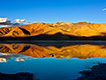
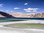
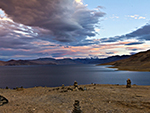
pangonglakebengali : "প্যাংগং লেকঃ-প্যাংগং লেক ধরণীতে বিধাতার এক বিশেষ আশীর্বাদ স্বরূপ। সমুদ্রপৃষ্ঠ থেকে প্রায় সাড়ে চোদ্দ হাজার ফুট ওপরে, ভারত ও চীনের সীমান্তবর্তী এলাকায়, অসংখ্য রুক্ষ পাহাড় আর মরুভূমির মধ্যে এই লবণাক্ত লেক অবস্থিত। ক্ষণে ক্ষণে নীল রঙের নানা পরিবর্তন, আর তার বিভিন্ন বিস্তার এই লেকের অন্যতম বৈশিষ্ট্য। কখনও হালকা নীল, কখনও গভীর, কখনো আকাশী আবার কখনও সবুজাভ নীল। এই নীলের রূপকথার চলচ্চিত্র দেখতে দেখতে মনে হবে পাথুরে পাহাড়ের ধূসর রঙের সঙ্গে মিলেমিশে তৈরি করেছে আর নতুন এক নীলের নান্দনিক শেড। তবে এই রূপ দেখলে, উচ্ছ্বাস আর আনন্দের সপ্নাভূতিতে, নিজেকে ধরে রাখা যায় না। নিজের ব্যক্তিত্ব বা রাশভারী গাম্ভীর্য এখানে হয়তো লোপ পেয়ে শিশুসুলভ করে তুলবে। ঝকঝকে নীল আকাশ, তার মধ্যে খণ্ড খণ্ড সাদা মেঘের আনাগোনা, আকাশ আর লেকের বন্ধুত্বে, স্বচ্ছ টলটলে জলে রং বদলের খেলা, লেকের উপরে রাজহাঁস, গাংচিলের চরে বেড়ানো, শোঁ শোঁ বাতাস, কনকনে ঠাণ্ডা পরিবেশ, মরুভূমির রুক্ষতা সত্ত্বেও মানুষ এই প্রাকৃতিক চিত্রশিল্পের এমন অপরূপ রূপের অবলোকনে নিজেকে ধরে রাখতে পারে না। কখনও শিশু হয়ে যায়, কখনো কখনও চলে যায় দুরন্ত কৈশোরে, কখনও প্রেমিক হয়ে হাত দুটো প্রসারিত করে গাইতে শুরু করে কোন প্রিয় গান আর যদি সে ফটোগ্রাফার হয় তবে সে কোন দিকে মন না দিয়ে তাড়াতাড়ি খুঁজবে সবথেকে ভাল পজিশন, সময় ও পরিবেশ আর আশঙ্কায় থাকবে যাতে তা বদল হয়ে না যায়। তবে এটা হলফ করে বলা যায় যে কেউই ছবি তুলে তৃপ্ত হবে না, কারণ দ্রুত পরিবর্তনশীল ফটোজিনিক এই লেকে যত ছবিই তোলা হোক না কেন, তা সবসময়ই চাহিদার থেকে কম হবে। আর এই অসম্ভব আকর্ষণের আবেগে সেই নীলাভ পরিবর্তন দেখতেই পর্যটকরা ছুটে যায় লে শহর থেকে ১৬৫ কি.মি. দূরের প্যাংগং লেকের পাড়ে। পথে পড়ে ১৭,৫৮৬ ফুট উচ্চতায় অবস্থিত চাংলা পাস যা পৃথিবীর তৃতীয় উচ্চতম গাড়ি চলার রাস্তা। এই রাস্তায়, পাহাড়ের ঢাল ও চূড়া অক্টোবর থেকে জুন মাস পর্যন্ত কয়েক ফুট বরফের চাদরে ঢেকে যায়। ঘন নীল আকাশের প্রেক্ষাপটে এই বরফে মোড়া চাংলার দৃশ্য বর্ণনা করার ক্ষমতা আমার নেই। এখানে রয়েছে সেনাবাহিনীর ক্যাফেটেরিয়া ও একটা মেডিকেল চেকআপ ইউনিট। প্যাংগং লেকের বিস্তার ১৩৪ কিলোমিটার, যার চল্লিশ শতাংশ ভারতের আর বাকি ষাট শতাংশ চীনের অন্তর্ভুক্ত। ম্যাপ অনুযায়ী পুরো প্যাংগং লেক ঘুরতে গেলে, একজনকে ভারত ও চীনের ডিফেন্স মিনিস্ট্রির অনুমতি নিতে হবে ও প্রায় ছশো কি.মি. পথ পরিক্রমা করতে হবে যার বেশিরভাগটাই পায়ে হেঁটে। প্যাংগং লেক পাহাড় ও ভূমি দিয়ে আবৃত একটা এণ্ডোরিক বেসিন যার অর্থ এখান থেকে জল নির্গমনের কোনও জায়গা নেই। প্যাংগং লেক ও এর আশপাশের অঞ্চলের স্বাভাবিক তাপমাত্রা পাঁচ থেকে দশ ডিগ্রি, যেটা শীতে হিমাঙ্কের থেকে পঁচিশ ডিগ্রি বা তারও নীচে চলে যায়। গ্রীষ্মে যে লেকে থাকে টলটলে নীল জলরাশি, শীতে সেই লেক জমে বরফ হয়ে যায়। আর এত সুন্দর জায়গাটা কিন্তু শান্তিতে নেই শুধুমাত্র কার দখলে থাকবে, এই নিয়ে চীন ভারতের প্রতিদিনের স্নায়ুযুদ্ধ থেকে আসল যুদ্ধ চলছে ষাটের দশক থেকে। গোলা বারুদের গন্ধে জায়গার পরিবেশ ও নিস্তব্ধতা দুইই বিঘ্নিত। এবার আসি কেন এত অশান্তি সেই প্রসঙ্গে। যদিও এটা ভ্রমণের অংশ নয় তবু জেনে রাখা ভাল।ইতিহাসঃ-বর্তমানে গ্যালওয়ান উপত্যকাসহ আরও বেশ কয়েকটা জায়গার দখল নিয়ে ভারত ও চিনের মধ্যে বিরোধ দেখা দিলেও, মূল বিতর্কের কেন্দ্রে রয়েছে ছবির মতো নীল জলের প্যাংগং লেক। প্রায় সাড়ে চোদ্দ হাজার ফুট উচ্চতায় অবস্থিত এই লেকের নাম আক্ষরিক অর্থে কনক্লেভ লেক বা গোপন বৈঠকের লেক। ১৯৬২ সালের ভারত-চিন যুদ্ধের পর ১৩৫ কি.মি. দীর্ঘ লেকের প্রায় ৪৫ কি.মি. ভারত নিয়ন্ত্রণ করে। বাকি অংশ রয়েছে চিনের দখলে। প্রকৃত নিয়ন্ত্রণরেখা গেছে এই লেকের মাঝখান দিয়েই। ইংরাজি, হিন্দি এবং চাইনিজ, তিন ভাষাতেই দুই দেশ তাদের অঞ্চল চিহ্নিত করে রেখেছে। এই হ্রদের পাশেই রয়েছে চ্যাং চেনমো নামে পরিচিত কারাকোরাম পর্বতমালার পূর্বদিকের বর্ধিত আটটা অংশ। হাতের আঙুলের মতো দেখতে এই এই পার্বত্য শাখাগুলোকে মিলিটারি ভাষায় আঙুল বা ফিঙ্গার বলা হয়। এই ফিঙ্গারের দখল নিয়েই মূল বিতর্ক। প্রকৃত নিয়ন্ত্রণরেখা নিয়ে ১৯৬২ সাল থেকেই ভারত ও চিনের মধ্যে দ্বন্দ্ব রয়েছে। ভারতের দাবি এই নিয়ন্ত্রণ রেখা গিয়েছে ফিঙ্গার-৮ দিয়ে। ভারতীয় সেনা পায়ে হেটে ফিঙ্গার-৮ পর্যন্ত টহল দেয় বটে, কিন্তু ফিঙ্গার-4 এর পরে ভারতীয় বাহিনীর সক্রিয় নিয়ন্ত্রণ কোনও দিনই ছিল না। অন্যদিকে চিনের দাবি প্রকৃত নিয়ন্ত্রণ-রেখা গিয়েছে ফিঙ্গার-৮ দিয়ে। তবে কখনও কখনও তারা হালকা যানবাহনে ফিঙ্গার-2 পর্যন্তও টহল দেয়। মে মাসে দুই বাহিনী মুখোমুখি হয়েছিল ফিঙ্গার-5 এর কাছে। বর্তমানে সমস্যা চলছে ফিঙ্গার-2 এর কাছে। বরাবরই চিন ফিঙ্গার-4 পর্যন্ত এলাকা দাবি করেছে। ২০১৪-১৫ সালে ভারতের তীব্র আপত্তিতে ফিঙ্গার-4 এর কাছে তাদেরই তৈরি একটা স্থায়ী কাঠামো ভেঙে দিয়েছিল চিন। তাতে মনে হয়েছিল চিনা কর্তৃপক্ষ পারস্পরিক বোঝাপড়ার উপর জোর দিচ্ছে। তবে ২০১৭ সালে ডোকলাম স্ট্যান্ডঅফের সময়ও চিনের সেনা ফিঙ্গার-4 পর্যন্ত এগিয়ে এসেছিল। তার আগে ১৯৯৯ সালে পাকিস্তানের সঙ্গে কার্গিল যুদ্ধের সময় প্যাংগং লেক এলাকা থেকে ভারত সেনা সরিয়ে নিয়ে গিয়েছিল অপারেশন বিজয়ে নিযুক্ত করতে। সেই ফাঁকে প্রকৃত নিয়ন্ত্রণরেখা টপকে ভারতীয় অংশে চিন প্যাংগং হদের পাশে প্রায় ৫ কিলোমিটার দীর্ঘ পাকা রাস্তা তৈরি করেছিল। সাম্প্রতিক আগ্রাসন তাদের এই দীর্ঘমেয়াদী পরিকল্পনারই অংশ বলে মনে করা হয়। বস্তুত প্যাংগং লেক স্ট্র্যাটিজিক দিক থেকে অত্যন্ত গুরুত্বপূর্ণ। কারণ এখান থেকে চুসুল উপত্যকা খুবই কাছে। ১৯৬২ সালের যুদ্ধের সময় এই চুসুল উপত্যকা ছিল অন্যতম যুদ্ধক্ষেত্র। ফিঙ্গার-4 পর্যন্ত উপস্থিত থাকতে পারলে চুসুল উপত্যকার উপর নজর রাখার ক্ষেত্রে কৌশলগত সুবিধা রয়েছে। এই কারণে বরাবরই চিন ভারতকে এই অঞ্চলের নিয়ন্ত্রণ নিতে বাধা দিয়েছে। প্যাংগং লেকের পুরোটা দখলে রাখতে পারলে, স্ট্র্যাটিজিক সুবিধা পাবে চিন। এই কারণেই তারা ভারতের সঙ্গে তুমুল দ্বন্দ্বে জড়িয়েছে। সেই সঙ্গে প্যাংগং লেক এবং গালওয়ান অঞ্চলে চিনা আগ্রাসনের আরও একটা কারণ রয়েছে। প্রকৃত নিয়ন্ত্রণ রেখার কাছে ভারত কোনও পরিকাঠামোগত উন্নয়ন করুক তা চিন একেবারেই চায় না। তাদের আশঙ্কা সেই ক্ষেত্রে হুমকির মুখে পড়বে তাদের আকসাই চিন এবং লাসা-কাশগড় হাইওয়ের দখলদারি। এতে করে পাকিস্তান এবং পাক-অধিকৃত লাদাখ ও জম্মু ও কাশ্মীরের অংশগুলোতে চিনের যে সাম্রাজ্যবাদী পরিকল্পনা রয়েছে তা ধাক্কা খাবে। ভারত এই মুহূর্তে দৌলতবেগ ওল্ডি থেকে দুরবুক হয়ে শিয়ক পর্যন্ত ২৫৫ কিলোমিটার লম্বা একটি রাস্তা তৈরি করছে। রাস্তা হয়ে গেলে কারাকোরাম পাসে ভারতীয় সেনার শেষ ঘাঁটির সঙ্গে দৌলতবেগ ওল্ডি বায়ুসেনা ঘাঁটির যোগাযোগ অনেক সহজ হয়ে যাবে। লে থেকে দৌলতবেগ ওল্ডির দূরত্ব দুদিন থেকে নেমে আসবে ছ ঘন্টায়। এই রাস্তা নির্মাণও চিনের মাথাব্যথার আর একটা কারণ। "+
"Read More..."+
"
"+
"শব্দঃ প্রতিবেদনঃ "+
""+
"ভিডিও"+
"স্লাইডশোর জন্যে নীচের ছবিতে ক্লিক করুন "+
"
"+
"পেজ মেনুতে যান",
pangonglakeenglish : "Pangong Lake:-Pangong Lake is one of the special blessings of God on earth. About fourteen and a half thousand feet above sea level, this Salt Lake is located in the border area of India and China, with numerous rough mountains and deserts. The blue color changes from time to time, and its spread is one of the features of this lake. Sometimes light blue, sometimes deep, sometimes azure and sometimes greenish blue. Watching this blue fairy tale movie, you will see that the rock has been created in harmony with the gray color of the mountain and a new aesthetic shade of blue. But seeing this form, in the dream of excitement and joy, one cannot hold oneself. Your own personality or seriousness may be lost here and make it childish. The bright blue sky, the fragmentation of white clouds in it, the friendship of sky and lake, the game of changing colors in clear crystal-clear water, the swan on the lake, the swan on the grass of Gangchil, the whistling wind, the cold environment in Kankan, can’t hold myself in observation. Sometimes he becomes a child, sometimes he goes into adolescence, sometimes he becomes a lover and starts singing his favorite song with outstretched arms and if he is a photographer, he will quickly look for the best position, time and environment and fear so that it does not change. However, I swear that no one will be satisfied with taking pictures, because no matter how many pictures are taken in this fast-changing photogenic lake, it will always be less than the demand. And seeing the bluish change in the emotion of this impossible attraction, the tourists rush to the city 175 km from Leh. In the distance on the shores of Pangong Lake. At 16,58 feet, the Changla Pass is the third highest driving road in the world. On this road, the slopes and peaks of the mountains are covered with a few feet of snow from October to June. I don't have the ability to describe the scene of this snow-covered Changla in the context of the dense blue sky. There is an army cafeteria and a medical checkup unit. Pangong Lake covers an area of 134 km, of which 40% is in India and the remaining 60% is in China. According to the map, to visit the entire Pangong Lake, one has to get permission from the Defense Ministries of India and China and cover a distance of about 600 km. You have to walk the path, most of which is on foot. Pangong Lake is an endorsement basin covered with hills and land, meaning there is no drainage. The average temperature in and around Pangong Lake is five to ten degrees Celsius, which drops to twenty-five degrees Celsius or below freezing in winter. The crystal-clear blue water of the lake in summer, the lake freezes in winter. And such a beautiful place, but not in peace, will be occupied only by car, this is the real war between China and India from the daily cold war since the sixties. The smell of ammunition disturbs both the atmosphere and the silence of the place. Now let's come to why there is so much unrest. Although it is not part of the trip, it is good to know.History:-Although India and China are currently embroiled in a dispute over the occupation of several other sites, including the Galvan Valley, the main point of contention is Pangong Lake in blue water, as pictured. Located at an altitude of about fourteen and a half thousand feet, the lake is literally called Conclave Lake. After the Sino-Indian war of 1962, 135 km. About 45 km long lake. India controls. The rest is occupied by China. The actual Line of Control runs through the middle of this lake. The two countries have identified their territories in English, Hindi and Chinese. Beside this lake are the eight extended eastern parts of the Karakoram Mountains known as the Chang Chenmo. These mountain branches, which look like the fingers of a hand, are called fingers in military parlance. The main controversy is over the possession of this finger. India and China have been at loggerheads over the Line of Control since 1972. India claims that the Line of Control has been crossed by Finger-6. The Indian Army patrolled on foot till Finger-6, but there was no active control of Indian forces after Finger-4. On the other hand, China's claim that the real Line of Control has gone through Finger-6. However, sometimes they patrol up to Finger-2 in light vehicles. The two armies clashed in May near Finger-5. Currently the problem is with Finger-2. China has always claimed territory up to Finger-4. In 2014-15, China demolished a permanent structure built by them near Finger-4 in the face of strong objections from India. It seemed that the Chinese authorities were insisting on mutual understanding. However, even during the Doklam standoff in 2016, the Chinese army came forward up to Finger-4. Earlier, during the Kargil war with Pakistan in 1999, Indian troops withdrew from the Pangong Lake area to conduct Operation Victory. In that gap, Chin built a 5 km long paved road on the Indian side of the Line of Control, next to the Pangong Hud. The recent aggression is thought to be part of their long-term plan. In fact, Pangong Lake is strategically important. Because Chusul valley is very close from here. The Chusul Valley was one of the battlefields during the 1962 war. There is a strategic advantage in keeping an eye on the Chusul Valley if it can be present up to Finger-4. For this reason, China has always prevented India from taking control of the region. If Pangong Lake can be fully occupied, China will have a strategic advantage. That is why they are in a bitter conflict with India. At the same time, there is another reason for Chinese aggression in Pangong Lake and Galwan. China does not want India to make any infrastructural development near the Line of Actual Control. Their fear is that their occupation of the Aksai Chin and Lhasa-Kashgarh highways will be threatened in that case. This would undermine China's imperialist plans in Pakistan and in Pakistan-occupied Ladakh and parts of Jammu and Kashmir. India is currently building a 255 km long road from Daulatbeg Oldi to Durbuk via Shiyak. Once the road is completed, the connection between Daulatbeg Oldi Air Force Base and the last Indian Army base near Karakoram will be much easier. The distance from Ley to Daulatbeg Oldi will come down from two days to six hours. The construction of this road is another reason for China's headache. "+
"Read More..."+
"
"+
"Sound Stream: "+
""+
"Video"+
"Click any Picture for Slide Show "+
"
"+
"Go To Page Menu",
photopangonglake :
""+
" "+
" "+
" "+
" "+
" "+
" "+
" "+
" "+
"",
tsokarlakebengali : "সো-করঃ-সো করকে বলা হয় হোয়াইট লেক ও লাদাকে যে তিনটে অতি উচ্চতার নোনা জলের লেক আছে তাদের মধ্যে একটা। একে হোয়াইট লেক বলে, কারণ এই লেকের ধারে সাদা নুনের প্রলেপ জমা হয়ে থাকে। লাদাখের তিনটে গুরুত্বপূর্ণ হ্রদের মধ্যে সো কর লেকটা সবচেয়ে ছোট। লে শহর থেকে প্রায় আড়াইশো কি.মি. দূরে রুপসু উপত্যকায় এর অবস্থান। দক্ষিণ পূর্ব লাদাখের চাংথাং অঞ্চলে অবস্থিত সো করের উচ্চতা ১৫,২৮০ ফুট। লেকটা আর একটা বড় নোনা জলের লেক সো-মরিরি থেকে প্রায় পঞ্চাশ কিলোমিটার দূরে অবস্থিত।সো কর লেক পাখি পর্যবেক্ষণের জন্যে খুবই জনপ্রিয়। লেকের আশেপাশের অঞ্চল বন্যপ্রাণী ও পাখি সমৃদ্ধ। পুরো লেকটাই ঘিরে আছে বিরাট জলাভূমি যেখানে বিচিত্র রকমের পাখির দেখা মেলে, বিশেষত ব্রাহ্মণী হাঁস, বার-হেডেড গুজ ও গ্রেট ক্রেস্টেড গ্রিব ইত্যাদি। তবে পাখির মধ্যে প্রধান আকর্ষণ হল ব্ল্যাক নেকড ক্রেন। জনমানবহীন ও খাদ্য সংগ্রহের সুবিধা থাকার ফলে এখানে তারা ডিম পাড়ে। ছবির মতো মনোরম সবুজ সমতলের প্রেক্ষাপটে, এই পাখিগুলো যখন তুষার ঢাকা পর্বতমালার ওপর দিয়ে ওড়ে তখন এক বিস্ময়কর দৃশ্য সৃষ্টি করে। পক্ষী পর্যবেক্ষণের পাশাপাশি সো-কর বন্যপ্রাণী পর্যবেক্ষকদেরও আকর্ষণ করে। একটু চেষ্টা করলেই দেখা মিলবে বহু সংখ্যায় বর্তমান স্তন্যপায়ী জীব কিয়াংস, যা বুনো গাধার জাতের মধ্যে বৃহত্তম। সো করের চারপাশের পাহাড় পর্বতে অ্যালপাইন আইবেক্স, স্নো ফক্স আর স্নো লেপার্ডেরও বাসস্থান। পাহাড় পর্বত বেষ্টিত, লেকটা নিজেই এক দুর্দান্ত প্রাকৃতিক দৃশ্য সৃষ্টি করেছে, যা ভীষণ রোমান্টিক লাগে সূর্যাস্তের সময়। সো করের দৃশ্য দিনের বেলায় যেমন মনোরম, তেমনই রাতের বেলায় আরও রোমাঞ্চকর হয়ে ওঠে, তবে তা যদি পূর্ণিমা হয় বা চাঁদের আলো থাকে। চাঁদের আলোতে চারপাশের পাহাড়গুলো জ্বলজ্বল করে আর লেকে তাদের ছায়াগুলো মনে হয় সীমাহীন পাহাড়ের এক সমুদ্র। লেকের সম্মোহনী দৃশ্য মনের মণিকোঠায় যে বহুদিন বিরাজমান থাকবে তা একপ্রকার নিশ্চিত। সো কর অঞ্চলে খাম্পাস নামে একটি যাযাবর গোষ্ঠী বাস করে। এরা গ্রীষ্মকালে বড় বড় তাঁবুতে, আর শীতকালে শক্তপোক্ত পাথরের কুঁড়েঘরে বাস করে। এদেরকে বলা হয় চাইনিজ কাউবয় ও পশুপালন এদের মূল জীবিকা। এরা মূলত ইয়াক, ভেড়া, ছাগল ইত্যাদি পালন করে। এরা আবার রূপসা চ্যাং নামে এক যাযাবর জাতি হিসেবেও পরিচিত। এই যাযাবর গোষ্ঠী সো কর থেকে নুন নিয়ে কাছাকাছি অঞ্চলে বিক্রি করে, নিজেদের প্রয়োজনীয় পণ্য সংগ্রহ করে ও এই কাজ তারা অনন্তকাল ধরে করে আসছে। "+
"Read More..."+
"
"+
"শব্দঃ প্রতিবেদনঃ "+
""+
"ভিডিও"+
"স্লাইডশোর জন্যে নীচের ছবিতে ক্লিক করুন "+
"
"+
"পেজ মেনুতে যান",
tsokarlakeenglish : "Tso Kar:-Tso Kar is called White Lake and Lada is one of the three very high salt water lakes. It is called White Lake because of the accumulation of white salt on the shores of this lake. So Kar Lake is the smallest of the three important lakes in Ladakh. About two hundred and fifty km from the city of Leh. Its location in the far Rupsu valley. So Kar, located in the Changthang region of southeastern Ladakh, is 15,280 feet high. The lake is about fifty kilometers away from another large saltwater lake, So-Moriri.So Kar Lake is very popular for bird watching. The area around the lake is rich in wildlife and birds. The whole lake is surrounded by huge wetlands where a variety of birds can be seen, especially Brahmani ducks, bar-headed goose and the Great Crested Grib. But the main attraction among the birds is the black naked crane. They lay eggs here due to lack of population and food collection facilities. Set against the backdrop of picturesque green plains, these birds create a spectacular view as they fly over the snow-capped mountains. In addition to bird watching, So-Kar also attracts wildlife observers. With a little effort, you'll find a large number of current mammals, the kiangs, the largest of the wild donkey breeds. Alpine ibex, snow fox and snow leopard are also found in the mountains around So Kar. Surrounded by mountains, the lake itself has created a great landscape, which looks very romantic at sunset. The view of So Kar becomes more thrilling at night as it is beautiful during the day, if it is full moon or moonlight. The surrounding mountains glow in the moonlight, and their shadows on the lake look like an ocean of boundless mountains. The mesmerizing view of the lake is sure to linger for a long time. A nomadic group called the Khampas live in the So Kar region. They live in large tents in summer and in hardened stone huts in winter. They are called Chinese cowboys and their main occupation is animal husbandry. They mainly keep yaks, sheep, goats etc. They are also known as a nomadic people called Rupsha Chang. This nomadic group takes salt from the so-called tax and sells it in the surrounding areas, collects their own necessities and they have been doing this for eternity. "+
"Read More..."+
"
"+
"Sound Stream: "+
""+
"Video"+
"Click any Picture for Slide Show "+
"
"+
"Go To Page Menu",
phototsokarlake :
""+
" "+
"",
tsomoririlakebengali : "সো-মরিরিঃ-লাদাখের চাংথাং অঞ্চলে অবস্থিত সো মরিরি লেক ভারতের অন্যতম অতি উচ্চতার এক নোনা জলের লেক। এই লেক খুব সুন্দর, শান্ত, আর লাদাখিদের কাছে অত্যন্ত পবিত্র। পুরোপুরি ভারতীয় উপমহাদেশে অবস্থিত অতি উচ্চতার লেকের মধ্যে এটাই সবথেকে বড়, যার নীল জলের ব্যাপ্তি উনিশ কি.মি. দীর্ঘ ও সাত কি.মি. চওড়া। জলাভূমি রিজার্ভ প্রকল্পের মধ্যে এই লেক রামসার সাইটের অধীনে হওয়ায়, এটা প্রকৃতপক্ষে সো মরিরি জলাভূমি সংরক্ষণ রিজার্ভ নামে পরিচিত। আর সেই নিয়ম অনুযায়ী লেকের কাছাকাছি নির্দিষ্ট এলাকার মধ্যে কেউ কোনও তাঁবু টাঙাতে বা কিছু নির্মাণ করতে পারবে না। এটা বিশ্বের সর্বোচ্চ রামসার সাইট। রামসার সাইট একটা জলাভূমি সাইট যা আন্তর্জাতিক গুরুত্বসম্পন্ন রামসার কনভেনশনে মনোনীত। জলাভূমির ওপর এই কনভেনশনের নাম রামসার কনভেনশন। এটা একটা আন্ত-সরকারি পরিবেশগত চুক্তি যা ১৯৭১ সালে ইউনেস্কো দ্বারা স্থাপিত ও ১৯৭৫ সাল থেকে এটা কার্যকর হয়। জলাভূমি সংরক্ষণের জন্যে জাতীয় তদারকি ও আন্তর্জাতিক সাহায্যের ওপর এই প্রকল্প দাঁড়িয়ে আছে ও জলাভূমি ব্যবহারের জন্য নির্দিষ্ট নীতি ও জলজ প্রাণীদের কোনও রকম ক্ষতি না করে যথাযথ ব্যবহার ও সংস্কারের কথা উল্লেখ আছে। সারা বিশ্বে প্রায় ২,৪০০ রামসার সাইট বর্তমান ও ভারতবর্ষে তার সংখ্যা বিয়াল্লিশ। এই অঞ্চলে প্রচুর পরিমাণে উদ্ভিজ্জ এবং প্রাণীজ উপকরণ পাওয়া যায়। ভারতীয় পর্যটকদের জন্যে সো মরিরি ঘোরার জন্যে কোন ইনারলাইন পারমিট লাগে না। বহু মাত্রার নীল বর্ণের ছায়াছবির সাথে মনোরম প্রাকৃতিক দৃশ্যের পারিপার্শ্বিকতা এই লেকের প্রধান বৈশিষ্ট্য। ফলে দর্শকের কাছে তা অত্যন্ত রোমান্টিক ও গভীরভাবে অনুভবী। কিন্তু বাস্তবে এই স্থান, কাল বিশেষে অত্যন্ত কঠোর, বিশেষত শীতকালে এখানে বেঁচে থাকা কঠিন। লেকের আশেপাশে কেবলমাত্র কয়েকটা আবাসন পাওয়া যায় আর বিদ্যুৎ, চিকিৎসা, গরম জল ইত্যাদি সুবিধা বিরল। অক্সিজেনের অভাব পর্যটকদের বেঁচে থাকা কঠিন করে তোলে, যদি কেউ নিজের শরীরকে অতি উচ্চ উচ্চতার সঙ্গে যথাযথভাবে খাপ খাইয়ে না নিতে পারে। তাই এই রোমান্টিক জায়গার প্রকৃত স্বাদ নিতে গেলে আগে শরীরকে অতি উচ্চতার সঙ্গে সহনশীল করে নিতে হবে। "+
"Read More..."+
"
"+
"শব্দঃ প্রতিবেদনঃ "+
""+
"ভিডিও"+
"স্লাইডশোর জন্যে নীচের ছবিতে ক্লিক করুন "+
"
"+
"পেজ মেনুতে যান",
tsomoririlakeenglish : "Tso Moriri:-Tso Moriri Lake, located in the Changthang region of Ladakh, is one of the highest salt water lakes in India. This lake is very beautiful, calm, and very sacred to Ladakhis. It is the largest of the highest lakes in the entire Indian subcontinent, with a range of 19 km of blue water. Long and seven km. Wide. As this lake is under the Ramsar site in the Wetlands Reserve Project, it is actually known as the So Moriri Wetlands Conservation Reserve. And according to that rule, no one can set up a tent or build anything in a certain area near the lake. It is the highest Ramsar site in the world. The Ramsar Site is a wetland site designated for the Ramsar Convention of International Importance. The name of this convention on wetlands is Ramsar Convention. It is an intergovernmental environmental treaty established by UNESCO in 1981 and has been in force since 1985. The project focuses on national oversight and international assistance for the conservation of wetlands, with specific policies for wetland use and the proper use and rehabilitation of aquatic animals without any harm. There are about 2,400 Ramsar sites in the world today and forty-two in India. This region is rich in vegetable and animal resources. No Inner line Permit is required for Indian tourists to visit So Moriri. The main feature of this lake is the beautiful scenery surrounded by a multitude of blue films. As a result, it feels very romantic and deeply felt by the audience. But in reality, this place is very hard to survive, especially in winter. Only a few houses are available in the vicinity of the lake and facilities like electricity, medical, hot water etc. are scarce. Lack of oxygen makes it difficult for tourists to survive if one cannot properly adapt one's body to very high altitudes. So, to get a real taste of this romantic place, you have to make the body tolerant with extreme heights first. "+
"Read More..."+
"
"+
"Sound Stream: "+
""+
"Video"+
"Click any Picture for Slide Show "+
"
 "+
"
"+
"  "+
"
"+
"  "+
"
"+
"  "+
"
"+
"  "+
"
"+
"  "+
"
"+
"  "+
"
"+
"  "+
"
"+
" "+
"
"+
"  "+
"
"+
"  "+
"
"+
"  "+
"
"+
"  "+
"
"+
"  "+
"
"+
"  "+
"
"+
"  "+
"",
lamayurubengali : "লামায়ারুঃ-লাদাখের পশ্চিমাঞ্চলে, লে শহর থেকে প্রায় ১২৭ কিলোমিটার দূরে অবস্থিত, পর্বতযুক্ত অনুর্বর এলাকার মধ্যে অবস্থিত লামায়ারু একটা অন্যতম জনপ্রিয় গ্রাম আর কার্গিল-লে রুটের এক আদর্শ বিরতিস্থান। এখানকার লামায়ারু বৌদ্ধ মঠ দেখার জন্যে পর্যটকরা আসেন ও অন্তত একদিন থেকে যান। একাদশ শতাব্দীতে লামায়ারু মনাস্ট্রি প্রতিষ্ঠা করেন মহাসিদ্ধাচার্য নরোপা। এই বৌদ্ধ মঠ প্রায় দেড় শতাধিক সন্ন্যাসীর সাধনাস্থল। এখানে রয়েছে একটা অত্যন্ত সমৃদ্ধশালী সংগ্রহশালা যা শিল্পকলা, প্রাচীরচিত্র, পটচিত্র, বিভিন্ন মূর্তি, কার্পেট এবং এগার মাথা ও একহাজার চোখযুক্ত চেনজিংয়ের এক চিত্তাকর্ষক মূর্তি। বৌদ্ধমঠ ছাড়াও লামায়ারু তার অপরূপ প্রাকৃতিক দৃশ্যের জন্য পর্যটকদের আকর্ষণ করে যা চাঁদের ঊষর অঞ্চলের সাথে বেশ সদৃশ। অঞ্চলটা দূরবর্তী ও কিছুটা বিচ্ছিন্ন এলাকা বলে এই জায়গাটা ফটোগ্রাফার এবং ট্রেকারদের একটা জনপ্রিয় প্রমোদভ্রমণ। লোককথা অনুযায়ী লামায়ারু মঠের ইতিহাস দশম শতাব্দীরও আগের, যখন ভারতীয় পণ্ডিত মহাসিদ্ধাচার্য নরোপা একটা হ্রদকে পুরোপুরি শুকিয়ে দিয়ে পুরো উপত্যকায় জলের ব্যবস্থা করেছিলেন। ঐ শুকনো এলাকায় তিনি লামায়ারু মঠের ভিত্তি প্রস্তর স্থাপন করেছিলেন। এখানকার প্রাচীনতম বৌদ্ধ মঠের নাম সেঙ্গ-গে-সাগাং ও তা মনাস্ট্রির দক্ষিণদিকে অবস্থিত। "+
"Read More..."+
"
"+
"",
lamayurubengali : "লামায়ারুঃ-লাদাখের পশ্চিমাঞ্চলে, লে শহর থেকে প্রায় ১২৭ কিলোমিটার দূরে অবস্থিত, পর্বতযুক্ত অনুর্বর এলাকার মধ্যে অবস্থিত লামায়ারু একটা অন্যতম জনপ্রিয় গ্রাম আর কার্গিল-লে রুটের এক আদর্শ বিরতিস্থান। এখানকার লামায়ারু বৌদ্ধ মঠ দেখার জন্যে পর্যটকরা আসেন ও অন্তত একদিন থেকে যান। একাদশ শতাব্দীতে লামায়ারু মনাস্ট্রি প্রতিষ্ঠা করেন মহাসিদ্ধাচার্য নরোপা। এই বৌদ্ধ মঠ প্রায় দেড় শতাধিক সন্ন্যাসীর সাধনাস্থল। এখানে রয়েছে একটা অত্যন্ত সমৃদ্ধশালী সংগ্রহশালা যা শিল্পকলা, প্রাচীরচিত্র, পটচিত্র, বিভিন্ন মূর্তি, কার্পেট এবং এগার মাথা ও একহাজার চোখযুক্ত চেনজিংয়ের এক চিত্তাকর্ষক মূর্তি। বৌদ্ধমঠ ছাড়াও লামায়ারু তার অপরূপ প্রাকৃতিক দৃশ্যের জন্য পর্যটকদের আকর্ষণ করে যা চাঁদের ঊষর অঞ্চলের সাথে বেশ সদৃশ। অঞ্চলটা দূরবর্তী ও কিছুটা বিচ্ছিন্ন এলাকা বলে এই জায়গাটা ফটোগ্রাফার এবং ট্রেকারদের একটা জনপ্রিয় প্রমোদভ্রমণ। লোককথা অনুযায়ী লামায়ারু মঠের ইতিহাস দশম শতাব্দীরও আগের, যখন ভারতীয় পণ্ডিত মহাসিদ্ধাচার্য নরোপা একটা হ্রদকে পুরোপুরি শুকিয়ে দিয়ে পুরো উপত্যকায় জলের ব্যবস্থা করেছিলেন। ঐ শুকনো এলাকায় তিনি লামায়ারু মঠের ভিত্তি প্রস্তর স্থাপন করেছিলেন। এখানকার প্রাচীনতম বৌদ্ধ মঠের নাম সেঙ্গ-গে-সাগাং ও তা মনাস্ট্রির দক্ষিণদিকে অবস্থিত। "+
"Read More..."+
" "+
"
"+
"  "+
"
"+
"  "+
"
"+
"  "+
"
"+
"  "+
"
"+
"  "+
"
"+
"  "+
"
"+
"  "+
"",
nubravalleybengali : "নুব্রা ভ্যালিঃ-শিয়ক ও নুব্রা নদীর উপত্যকা যেন খাড়া পাহাড়ের বুক চিরে বেরিয়ে এসে শ্রেষ্ঠত্বের আভিজাত্যে তৈরি করেছে এক বিস্ময়কর দৃশ্য, যেখানে রয়েছে মরূদ্যানের মতো পান্না সবুজ বৃক্ষরাজি সমৃদ্ধ গ্রাম, যার চতুর্দিক পরিবেষ্টন করে আছে নুড়ি পাথরের ঢাল, বড় বড় পাথরের চাঁইয়ের বিশাল বিস্তার, রূঢ় শুকনো ধূসর পাহাড় ও ঘন নীল পরিষ্কার আকাশ। রয়েছে পাহাড়ি বালিয়াড়ি, বৌদ্ধ মঠ, একটা ভাঙাচোরা প্রাসাদ আর তুরতুক ও বোগডাঙের একেবারে ভিন্ন সংস্কৃতি। নুব্রা ভ্যালি লাদাখের হৃদয় ও যে কোনও ভ্রমণার্থীর ভ্রমণসূচির অবশ্য উপাদান। লে শহর থেকে প্রায় ১২০ কি.মি. দূরে লাদাখের উত্তরপূর্বে অবস্থিত এই উপত্যকার প্রধান কার্যালয় ডিসকিট। শিয়ক নদী যা সিন্ধু নদের এক শাখানদী ও নুব্রা নদী বা সিয়াচেন নদী এখানেই মিলিত হয়ে তৈরি করেছে এক বিশাল উপত্যকা ও তা লাদাখ ও কারাকোরাম রেঞ্জকে আলাদা করে রেখেছে। এই দুটো নদীই সিয়েচেন হিমবাহের দু প্রান্ত থেকে উৎপন্ন হয়েছে। অতি বিস্তৃত দৃশ্যপট, বিশাল বিশাল পর্বতমালা, অতীব সুন্দর আঁকাবাঁকা পাহাড়ি রাস্তা, বৈচিত্র্যপূর্ণ রঙের মিলন আর উপত্যকার বুক চিরে বেরিয়ে আসা শিয়ক নদীর সুরেলা গীতিনাট্য, প্রথম দর্শনেই পর্যটকদের অনুরাগের কারণ হয়ে যাবে।তবে এমন সুন্দর স্থানে যাবার পথ পর্যটকদের জন্যে বছরের বেশিরভাগ সময়ই বন্ধ থাকে। কারণ লে থেকে নুব্রা ভ্যালি যেতে হলে পার করতে হবে পৃথিবীর সর্বোচ্চ গাড়ি চলার রাস্তা খারদুংলা পাস। খারদুংলা পাসের উচ্চতা ১৮,৩৮০ ফুট আর ভিউ পয়েন্টের উচ্চতা ১৭,৯৮২ ফুট। মে থেকে আগস্ট মাস পর্যন্ত এই রাস্তা পর্যটকদের জন্য খোলা থাকে। এখানে আসতে হলে অতি উচ্চতার আবহাওয়ার সঙ্গে খাপ খাইয়ে নেওয়ার জন্যে, লে শহর বা তার কাছাকাছি কোথাও দু তিন দিন কাটানো অবশ্যই প্রয়োজন। লে থেকে খারদুংলা পাসের দূরত্ব চল্লিশ কিলোমিটার। প্রথম কুড়ি কি.মি. রাস্তা ভাল হলেও বাকি পথ বন্ধুর। মাঝে মাঝেই ধস বা বরফের কারণে রাস্তা বন্ধ হয়ে যায় এবং বর্ডার রোড অর্গানাইজেশন দ্বারা রাস্তা পরিষ্কার করার পর আবার গাড়ি চলা শুরু হয়। খারদুংলা পাসের উত্তর ও দক্ষিণ দিকে দুটো চেকপোস্টের মাধ্যমে যানবাহন চলাচল নিয়ন্ত্রণ করা হয়। একে তো উচ্চতা তার ওপর বছরের বেশিরভাগ সময়ই খারদুংলার তাপমাত্রা খুব কম থাকে। তাই পর্যটকরা এখানে বেশিক্ষণ থাকেন না। শিয়ক নদীর তীর বরাবর গড়ে উঠেছে ডিসকিট ও হুন্ডার গ্রাম। আর নুব্রা নদীর তীরে গড়ে ওঠা গ্রামগুলো হল সুমুর, টিগ্গুর, পানামিক ইত্যাদি। লে শহর থেকে নুব্রা ভ্যালি পৌঁছতে সময় লাগে ৬-৭ ঘণ্টার মতো। কিন্তু খারাপ রাস্তা ও অন্যান্য কারণে বেশি সময়ও লেগে যায়। সিয়ক ও নুব্রা নদীর সঙ্গমস্থল থেকে খালসার থেকে বাঁদিকের রাস্তা ধরে ২২ কিলোমিটার দূরে ডিসকিট গ্রাম। নুব্রা উপত্যকার সবথেকে বড় গুম্ফা, ডিসকিট গ্রামের পাহাড়ের মাথায় অবস্থিত। খালসার থেকে ডিসকিটের রাস্তার সৌন্দর্য অপূর্ব। পান্না সবুজ উপত্যকার মধ্যে দিয়ে দুধসাদা সিয়ক নদী বয়ে চলেছে তার নিজস্ব খেয়ালে। দুরের পাহাড় কোথাও নীল, কোথাও ধুসর, কোথাও বা হলদে। প্রাচীনকালের সিল্করুটও এই উপত্যকা ধরেই তিব্বতে যেত। ডিসকিট গ্রাম হল নুব্রা ভ্যালির হেড কোয়ার্টার। ডিসকিটকে নুব্রা ভ্যালির চাষের বাগানও বলা হয়ে থাকে। কারণ এখানে সবচেয়ে বেশী চাষ হয়ে থাকে সর্ষে, মটরশুঁটি, বার্লি, অপ্রিকট, আমন্ড প্রভৃতি। ডিসকিট অঞ্চলে প্রবেশ করার সঙ্গে সঙ্গে একটা ছোট পাহাড়ের মাথায় বত্রিশ মিটার লম্বা বিখ্যাত মৈত্রেয়ী বৌদ্ধমূর্তি দেখতে পাওয়া যায়। পাহাড়ের পাদদেশ থেকে দশ মিনিটের গাড়ির ঘোরানো সুন্দর রাস্তায় উঠে যাওয়া যায় মূর্তির কাছে। রাস্তার চারদিকে রংবেরঙের প্রার্থনা পতাকা, সাদা চোর্তেন আর ডিসকিট গ্রামের দৃশ্য অপূর্ব সুন্দর লাগে। গাড়িতে না গিয়ে হেঁটেও ওঠা যায় তবে তা বেশ কষ্টকর, কিন্তু পাওনা হবে অনেকটাই বেশি। খোলা জায়গায় বিশাল রঙিন বৌদ্ধমূর্তি দাঁড়িয়ে আছে শিয়ক নদীর দিকে মুখ করে। পেছনে ধুসর পাহাড়। চাতাল থেকে হিমালয় রেঞ্জের দৃশ্য বড় মনোরম। ডিসকিটের আর এক দ্রষ্টব্য হল সাড়ে তিনশো বছরের পুরানো ডিসকিট মনাস্ট্রি আর লাচুং টেম্পল। কাছেই রয়েছে হুণ্ডার গ্রাম। এই গ্রামের পাশেই আছে লাদাখের অন্যতম প্রধান দ্রষ্টব্য শীতল মরুভূমি। এই মরুভূমির বালির রং সাদা। মরুভূমির মধ্যে আছে ঢেউ খেলানো বালিয়াড়ি আর তার বুকে চরে বেড়ায় লাদাখের বিখ্যাত দু কুঁজ বিশিষ্ট ব্যাকট্রিয়ান উট। এই উট ভারতে একমাত্র এই জায়গাতেই দেখা যায়। সম্ভবত মোঙ্গল আক্রমণকারীরা এই উটগুলো ভারতে নিয়ে এসেছিলেন। সাদা বরফে মোড়া সুউচ্চ শৃঙ্গ আর মরুভূমির বালিয়াড়িকে এক ফ্রেমে ধরা যায় এই হুণ্ডারেই। হুণ্ডারে একটা আর্মি মেডিক্যাল ক্যাম্প আছে। পর্যটকরা কোনও কারণে অসুস্থ বোধ করলে মিলিটারিরা খুব সহযোগিতা করেন। এখান থেকে সিয়েচেন গ্লেসিয়ারের দূরত্ব প্রায় ৯০ কি.মি.। আমরা সবাই জানি সিয়াচেন গ্লেসিয়ার পৃথিবীর সবথেকে উঁচু যুদ্ধক্ষেত্র। কিন্তু কেন ? কি কারণে যুদ্ধ ? হিমাঙ্কের ৫৫ ডিগ্রি নীচে তাপমাত্রা চলে যাওয়া সত্যেও সারা বছর ধরে মিলিটারি পোস্টিং রাখা হয় কেন ? নীচের লাইনগুলো বলে দেবে তার ইতিহাস।ইতিহাসঃ- সিয়াচেন দ্বন্দ্ব ভারত ও পাকিস্তানের মধ্যে কাশ্মীরের সিয়াচেন হিমবাহের অধিকারের জন্য সামরিক দ্বন্দ্ব। ১৯৮৪ সালে ভারতের সফল সামরিক অভিযান অপারেশন মেঘদূতের মাধ্যমে এই দ্বন্দ্বের সূত্রপাত হয়। সিয়াচেন হিমবাহ পৃথিবীর উচ্চতম যুদ্ধক্ষেত্র, যেখানে ভারত ও পাকিস্তান ১৯৮৪ সাল থেকে পরস্পরের বিরুদ্ধে লড়াই করে চলেছে। দু দেশই এই স্থানে ৬,০০০ মিটারের বেশি উচ্চতায় স্থায়ী সামরিক উপস্থিতি বজায় রেখেছে। এই দ্বন্দ্বের ফলে উভয় পক্ষের প্রায় ২০০০ মানুষ প্রচণ্ড শৈত্যে ও প্রাকৃতিক দুর্যোগের বলি হয়েছেন। ১৯৪৯ সালে ভারত, পাকিস্তান ও সম্মিলিত জাতিপুঞ্জের সামরিক পর্যবেক্ষক দল যুদ্ধবিরতি রেখা চুক্তিতে সই করে। ১৯৫৭ সালে পাকিস্তান, ব্রিটিশ পর্বতারোহী এরিক শিপটনের নেতৃত্বে বাইলাফন্ড গিরিবর্ত্ম হয়ে সিয়াচেন হিমবাহ অভিযানে সম্মতি প্রদান করে। পাঁচ বছর পরে এক জাপানী অভিযাত্রী দল সালতোরো কাংরি শৃঙ্গ অভিযান করেন। ১৯৬৩ সালে চিন, পাকিস্তানকে, ভারতীয় এলাকা সাক্সগাম উপত্যকা, প্রদান করার পর পাকিস্তান K-2 পর্বতশৃঙ্গে পশ্চিমী অভিযানে সম্মতি প্রদান করে। ১৯৬৭ সাল পর্যন্ত সম্মিলিত জাতিপুঞ্জ, পাকিস্তান ও অন্যান্যরা যুদ্ধবিরতি রেখা চুক্তি অনুযায়ী মানচিত্র প্রদর্শন করে। কিন্তু ১৯৬৭ সালেই ইউনাইটেড স্টেটস ডিফেন্স ম্যাপিং এজেন্সি, কোন রকম তথ্যসূত্র ছাড়াই তাদের মানচিত্রে কারাকোরাম গিরিবর্ত্মের পূর্ব ও দক্ষিণপূর্ব অঞ্চলকে চীনের অংশ হিসেবে বর্ণনা করে ও সিয়াচেন অঞ্চলকে পাকিস্তানের অংশ হিসাবে বর্ণনা করা হয়। ১৯৭১ সালে সিয়াচেন হিমবাহ অঞ্চলের সীমান্ত সংক্রান্ত সিমলা চুক্তিতে ভারতের অবস্থান অস্পষ্ট, এবং অসম্পূর্ণ ভাবে সংজ্ঞায়িত মার্কিন মানচিত্রের ওপর ভিত্তি করে পাকিস্তানের দাবীর কারণে এই দ্বন্দ্ব শুরু হয়। ফলে প্রায় এক দশক ধরে এই এলাকার বিভিন্ন পর্বতশৃঙ্গ, বাইলাফন্ড, সিয়াচেন ইত্যাদি হিমবাহে অভিযানের জন্যে পর্বতারোহীরা পাকিস্তানের কাছ থেকে অনুমতি নিতো। ভারতের মৌনতা বা গাফিলতি, পাকিস্তানকে এইসব অঞ্চলের মালিকানার দাবি জানাতে উৎসাহিত করে। পরবর্তীকালে ভারত সরকার ও সেনাবাহিনী সব কিছু লক্ষ্য করে মার্কিন মানচিত্রের ব্যাপারে প্রতিবাদ জানায়। মার্কিন মানচিত্রের প্রভাব ও পাকিস্তানের অনুমতিপত্রের গুরুত্ব অনুভব করে, ১৯৭৮ সালে ভারতীয় সেনাবাহিনীর হাই অল্টিচিউড ওয়ারফেয়ার স্কুল, সিয়াচেন অঞ্চলে টেরাম কাংরি-2 পর্বতশৃঙ্গে সেনা পর্বতারোহণ অভিযান করে। ইতিমধ্যে ভারতীয় গোয়েন্দা সংস্থা খবর পায় যে রাওয়ালপিন্ডির সামরিক ঘাঁটিতে পাকিস্তানের জেনারেলরা ভারতের আগেই সিয়াচেন দখল করার সিদ্ধান্ত নিয়েছেন। কিন্তু পাকিস্তানের সামরিক অভিযানের আগাম খবর পেয়ে ১৯৮৪ সালে ভারতীয় সেনাবাহিনী ও বিমানবাহিনী অপারেশন মেঘদূত শুরু করে। শীঘ্রই ভারত সিয়াচেন অঞ্চল নিজেদের অধিকারে নিয়ে নেয়। সিয়া ও বাইলাফন্ড গিরিবর্ত্ম ভারতের দখলে আসে। এর সাতদিন পরে পাকিস্তানি সেনাবাহিনী এই স্থানে পৌছলেও তাদের আগেই ভারতীয় সেনাবাহিনীর তিনশো সেনা পর্বতশীর্ষগুলো দখল করে নেয়। ১৯৮৪ সালের পর পাকিস্তান সিয়াচেন দখল নেওয়ার জন্যে বহুবার ব্যর্থ অভিযান করে। এর মধ্যে ১৯৮৭ সালের আক্রমণ ছিল সব চেয়ে উল্লেখযোগ্য। এই আক্রমণের নেতৃত্ব দেন জেনারেল পারভেজ মুশারফ। তিনি স্পেশাল সার্ভিসেস গ্রুপের একটা সদ্য তৈরি কমান্ডো দলের আট হাজার সৈন্যের এক বিশেষ গ্যারিসনকে বাইলাফন্ড গিরিবর্ত্ম দখলের জন্য পাঠান। কিন্তু অপারেশন রাজীব নামক তীব্র যুদ্ধের পর পাকিস্তানি সেনা পিছু হটতে বাধ্য হয়। সেই বছর পাকিস্তানের কায়েদ নামে একটা গুরুত্বপূর্ণ ঘাঁটি হাতছাড়া হয়। এই কাজটা করেন নায়েব সুবেদার বানা সিং, যিনি দিনের বেলায় ১,৫০০ ফুট খাড়া বরফের দেওয়াল ক্লাইম্ব করে ২২,১৪৩ ফুট উচ্চতায় অবস্থিত ঐ ঘাঁটি দখল করেন। তিনি ভারতের সর্বোচ্চ সাহসিকতার পুরস্কার পরমবীর চক্র লাভ করেন। এর পরেও পাকিস্তান অনেকবার সিয়াচেন দখলের জন্য আক্রমণ করে। ১৯৯৫ সালের আক্রমণে পাকিস্তানের স্পেশাল সার্ভিসেস গ্রুপের চল্লিশ জন সৈন্য নিহত হন।সিয়াচেন দ্বন্দ্বের ফলে ৯০০-১০০০ বর্গমাইল এলাকা ভারতের দখলে চলে আসে। ফলে ভারত ৭০ কি.মি. দীর্ঘ সিয়াচেন হিমবাহ ও তার সমস্ত প্রশাখা হিমবাহ এবং সিয়াচেন হিমবাহের পশ্চিমদিকে অবস্থিত সালতোরো পর্বতশ্রেণীর সিয়া, বাইলাফন্ড, ও গ্যোং এই তিনটে প্রধান গিরিবর্ত্ম নিজেদের দখলে আনে। অপরদিকে পাকিস্তান সালতোরো পর্বতশ্রেণীর পশ্চিমদিকে অবস্থিত হিমবাহ উপত্যকাগুলোকে অধিকার করে। বর্তমানে ২১,০০০ ফুট উচ্চতায় পয়েন্ট সোনমে বিশ্বের উচ্চতম হেলিপ্যাড স্থাপিত হয়েছে। সাথে মিলিটারিদের পরিবারের সাথে যোগাযোগের জন্যে পৃথিবীর সব থেকে উঁচু টেলিফোন টাওয়ারও তৈরি হয়েছে। সালতোরো পর্বতশ্রেণী আরোহণ করে পাকিস্তান যেমন ভারতের এলাকায় আসতে পারেনি, ভারতও তাদের কৌশলগত সুবিধাজনক উচ্চ অবস্থান ছাড়েনি। এই দুই সেনাবাহিনীর সামরিক অবস্থানের মধ্যের সীমারেখাকে প্রকৃত লাইন অফ কন্ট্রোল বলে। "+
"Read More..."+
"
"+
"",
nubravalleybengali : "নুব্রা ভ্যালিঃ-শিয়ক ও নুব্রা নদীর উপত্যকা যেন খাড়া পাহাড়ের বুক চিরে বেরিয়ে এসে শ্রেষ্ঠত্বের আভিজাত্যে তৈরি করেছে এক বিস্ময়কর দৃশ্য, যেখানে রয়েছে মরূদ্যানের মতো পান্না সবুজ বৃক্ষরাজি সমৃদ্ধ গ্রাম, যার চতুর্দিক পরিবেষ্টন করে আছে নুড়ি পাথরের ঢাল, বড় বড় পাথরের চাঁইয়ের বিশাল বিস্তার, রূঢ় শুকনো ধূসর পাহাড় ও ঘন নীল পরিষ্কার আকাশ। রয়েছে পাহাড়ি বালিয়াড়ি, বৌদ্ধ মঠ, একটা ভাঙাচোরা প্রাসাদ আর তুরতুক ও বোগডাঙের একেবারে ভিন্ন সংস্কৃতি। নুব্রা ভ্যালি লাদাখের হৃদয় ও যে কোনও ভ্রমণার্থীর ভ্রমণসূচির অবশ্য উপাদান। লে শহর থেকে প্রায় ১২০ কি.মি. দূরে লাদাখের উত্তরপূর্বে অবস্থিত এই উপত্যকার প্রধান কার্যালয় ডিসকিট। শিয়ক নদী যা সিন্ধু নদের এক শাখানদী ও নুব্রা নদী বা সিয়াচেন নদী এখানেই মিলিত হয়ে তৈরি করেছে এক বিশাল উপত্যকা ও তা লাদাখ ও কারাকোরাম রেঞ্জকে আলাদা করে রেখেছে। এই দুটো নদীই সিয়েচেন হিমবাহের দু প্রান্ত থেকে উৎপন্ন হয়েছে। অতি বিস্তৃত দৃশ্যপট, বিশাল বিশাল পর্বতমালা, অতীব সুন্দর আঁকাবাঁকা পাহাড়ি রাস্তা, বৈচিত্র্যপূর্ণ রঙের মিলন আর উপত্যকার বুক চিরে বেরিয়ে আসা শিয়ক নদীর সুরেলা গীতিনাট্য, প্রথম দর্শনেই পর্যটকদের অনুরাগের কারণ হয়ে যাবে।তবে এমন সুন্দর স্থানে যাবার পথ পর্যটকদের জন্যে বছরের বেশিরভাগ সময়ই বন্ধ থাকে। কারণ লে থেকে নুব্রা ভ্যালি যেতে হলে পার করতে হবে পৃথিবীর সর্বোচ্চ গাড়ি চলার রাস্তা খারদুংলা পাস। খারদুংলা পাসের উচ্চতা ১৮,৩৮০ ফুট আর ভিউ পয়েন্টের উচ্চতা ১৭,৯৮২ ফুট। মে থেকে আগস্ট মাস পর্যন্ত এই রাস্তা পর্যটকদের জন্য খোলা থাকে। এখানে আসতে হলে অতি উচ্চতার আবহাওয়ার সঙ্গে খাপ খাইয়ে নেওয়ার জন্যে, লে শহর বা তার কাছাকাছি কোথাও দু তিন দিন কাটানো অবশ্যই প্রয়োজন। লে থেকে খারদুংলা পাসের দূরত্ব চল্লিশ কিলোমিটার। প্রথম কুড়ি কি.মি. রাস্তা ভাল হলেও বাকি পথ বন্ধুর। মাঝে মাঝেই ধস বা বরফের কারণে রাস্তা বন্ধ হয়ে যায় এবং বর্ডার রোড অর্গানাইজেশন দ্বারা রাস্তা পরিষ্কার করার পর আবার গাড়ি চলা শুরু হয়। খারদুংলা পাসের উত্তর ও দক্ষিণ দিকে দুটো চেকপোস্টের মাধ্যমে যানবাহন চলাচল নিয়ন্ত্রণ করা হয়। একে তো উচ্চতা তার ওপর বছরের বেশিরভাগ সময়ই খারদুংলার তাপমাত্রা খুব কম থাকে। তাই পর্যটকরা এখানে বেশিক্ষণ থাকেন না। শিয়ক নদীর তীর বরাবর গড়ে উঠেছে ডিসকিট ও হুন্ডার গ্রাম। আর নুব্রা নদীর তীরে গড়ে ওঠা গ্রামগুলো হল সুমুর, টিগ্গুর, পানামিক ইত্যাদি। লে শহর থেকে নুব্রা ভ্যালি পৌঁছতে সময় লাগে ৬-৭ ঘণ্টার মতো। কিন্তু খারাপ রাস্তা ও অন্যান্য কারণে বেশি সময়ও লেগে যায়। সিয়ক ও নুব্রা নদীর সঙ্গমস্থল থেকে খালসার থেকে বাঁদিকের রাস্তা ধরে ২২ কিলোমিটার দূরে ডিসকিট গ্রাম। নুব্রা উপত্যকার সবথেকে বড় গুম্ফা, ডিসকিট গ্রামের পাহাড়ের মাথায় অবস্থিত। খালসার থেকে ডিসকিটের রাস্তার সৌন্দর্য অপূর্ব। পান্না সবুজ উপত্যকার মধ্যে দিয়ে দুধসাদা সিয়ক নদী বয়ে চলেছে তার নিজস্ব খেয়ালে। দুরের পাহাড় কোথাও নীল, কোথাও ধুসর, কোথাও বা হলদে। প্রাচীনকালের সিল্করুটও এই উপত্যকা ধরেই তিব্বতে যেত। ডিসকিট গ্রাম হল নুব্রা ভ্যালির হেড কোয়ার্টার। ডিসকিটকে নুব্রা ভ্যালির চাষের বাগানও বলা হয়ে থাকে। কারণ এখানে সবচেয়ে বেশী চাষ হয়ে থাকে সর্ষে, মটরশুঁটি, বার্লি, অপ্রিকট, আমন্ড প্রভৃতি। ডিসকিট অঞ্চলে প্রবেশ করার সঙ্গে সঙ্গে একটা ছোট পাহাড়ের মাথায় বত্রিশ মিটার লম্বা বিখ্যাত মৈত্রেয়ী বৌদ্ধমূর্তি দেখতে পাওয়া যায়। পাহাড়ের পাদদেশ থেকে দশ মিনিটের গাড়ির ঘোরানো সুন্দর রাস্তায় উঠে যাওয়া যায় মূর্তির কাছে। রাস্তার চারদিকে রংবেরঙের প্রার্থনা পতাকা, সাদা চোর্তেন আর ডিসকিট গ্রামের দৃশ্য অপূর্ব সুন্দর লাগে। গাড়িতে না গিয়ে হেঁটেও ওঠা যায় তবে তা বেশ কষ্টকর, কিন্তু পাওনা হবে অনেকটাই বেশি। খোলা জায়গায় বিশাল রঙিন বৌদ্ধমূর্তি দাঁড়িয়ে আছে শিয়ক নদীর দিকে মুখ করে। পেছনে ধুসর পাহাড়। চাতাল থেকে হিমালয় রেঞ্জের দৃশ্য বড় মনোরম। ডিসকিটের আর এক দ্রষ্টব্য হল সাড়ে তিনশো বছরের পুরানো ডিসকিট মনাস্ট্রি আর লাচুং টেম্পল। কাছেই রয়েছে হুণ্ডার গ্রাম। এই গ্রামের পাশেই আছে লাদাখের অন্যতম প্রধান দ্রষ্টব্য শীতল মরুভূমি। এই মরুভূমির বালির রং সাদা। মরুভূমির মধ্যে আছে ঢেউ খেলানো বালিয়াড়ি আর তার বুকে চরে বেড়ায় লাদাখের বিখ্যাত দু কুঁজ বিশিষ্ট ব্যাকট্রিয়ান উট। এই উট ভারতে একমাত্র এই জায়গাতেই দেখা যায়। সম্ভবত মোঙ্গল আক্রমণকারীরা এই উটগুলো ভারতে নিয়ে এসেছিলেন। সাদা বরফে মোড়া সুউচ্চ শৃঙ্গ আর মরুভূমির বালিয়াড়িকে এক ফ্রেমে ধরা যায় এই হুণ্ডারেই। হুণ্ডারে একটা আর্মি মেডিক্যাল ক্যাম্প আছে। পর্যটকরা কোনও কারণে অসুস্থ বোধ করলে মিলিটারিরা খুব সহযোগিতা করেন। এখান থেকে সিয়েচেন গ্লেসিয়ারের দূরত্ব প্রায় ৯০ কি.মি.। আমরা সবাই জানি সিয়াচেন গ্লেসিয়ার পৃথিবীর সবথেকে উঁচু যুদ্ধক্ষেত্র। কিন্তু কেন ? কি কারণে যুদ্ধ ? হিমাঙ্কের ৫৫ ডিগ্রি নীচে তাপমাত্রা চলে যাওয়া সত্যেও সারা বছর ধরে মিলিটারি পোস্টিং রাখা হয় কেন ? নীচের লাইনগুলো বলে দেবে তার ইতিহাস।ইতিহাসঃ- সিয়াচেন দ্বন্দ্ব ভারত ও পাকিস্তানের মধ্যে কাশ্মীরের সিয়াচেন হিমবাহের অধিকারের জন্য সামরিক দ্বন্দ্ব। ১৯৮৪ সালে ভারতের সফল সামরিক অভিযান অপারেশন মেঘদূতের মাধ্যমে এই দ্বন্দ্বের সূত্রপাত হয়। সিয়াচেন হিমবাহ পৃথিবীর উচ্চতম যুদ্ধক্ষেত্র, যেখানে ভারত ও পাকিস্তান ১৯৮৪ সাল থেকে পরস্পরের বিরুদ্ধে লড়াই করে চলেছে। দু দেশই এই স্থানে ৬,০০০ মিটারের বেশি উচ্চতায় স্থায়ী সামরিক উপস্থিতি বজায় রেখেছে। এই দ্বন্দ্বের ফলে উভয় পক্ষের প্রায় ২০০০ মানুষ প্রচণ্ড শৈত্যে ও প্রাকৃতিক দুর্যোগের বলি হয়েছেন। ১৯৪৯ সালে ভারত, পাকিস্তান ও সম্মিলিত জাতিপুঞ্জের সামরিক পর্যবেক্ষক দল যুদ্ধবিরতি রেখা চুক্তিতে সই করে। ১৯৫৭ সালে পাকিস্তান, ব্রিটিশ পর্বতারোহী এরিক শিপটনের নেতৃত্বে বাইলাফন্ড গিরিবর্ত্ম হয়ে সিয়াচেন হিমবাহ অভিযানে সম্মতি প্রদান করে। পাঁচ বছর পরে এক জাপানী অভিযাত্রী দল সালতোরো কাংরি শৃঙ্গ অভিযান করেন। ১৯৬৩ সালে চিন, পাকিস্তানকে, ভারতীয় এলাকা সাক্সগাম উপত্যকা, প্রদান করার পর পাকিস্তান K-2 পর্বতশৃঙ্গে পশ্চিমী অভিযানে সম্মতি প্রদান করে। ১৯৬৭ সাল পর্যন্ত সম্মিলিত জাতিপুঞ্জ, পাকিস্তান ও অন্যান্যরা যুদ্ধবিরতি রেখা চুক্তি অনুযায়ী মানচিত্র প্রদর্শন করে। কিন্তু ১৯৬৭ সালেই ইউনাইটেড স্টেটস ডিফেন্স ম্যাপিং এজেন্সি, কোন রকম তথ্যসূত্র ছাড়াই তাদের মানচিত্রে কারাকোরাম গিরিবর্ত্মের পূর্ব ও দক্ষিণপূর্ব অঞ্চলকে চীনের অংশ হিসেবে বর্ণনা করে ও সিয়াচেন অঞ্চলকে পাকিস্তানের অংশ হিসাবে বর্ণনা করা হয়। ১৯৭১ সালে সিয়াচেন হিমবাহ অঞ্চলের সীমান্ত সংক্রান্ত সিমলা চুক্তিতে ভারতের অবস্থান অস্পষ্ট, এবং অসম্পূর্ণ ভাবে সংজ্ঞায়িত মার্কিন মানচিত্রের ওপর ভিত্তি করে পাকিস্তানের দাবীর কারণে এই দ্বন্দ্ব শুরু হয়। ফলে প্রায় এক দশক ধরে এই এলাকার বিভিন্ন পর্বতশৃঙ্গ, বাইলাফন্ড, সিয়াচেন ইত্যাদি হিমবাহে অভিযানের জন্যে পর্বতারোহীরা পাকিস্তানের কাছ থেকে অনুমতি নিতো। ভারতের মৌনতা বা গাফিলতি, পাকিস্তানকে এইসব অঞ্চলের মালিকানার দাবি জানাতে উৎসাহিত করে। পরবর্তীকালে ভারত সরকার ও সেনাবাহিনী সব কিছু লক্ষ্য করে মার্কিন মানচিত্রের ব্যাপারে প্রতিবাদ জানায়। মার্কিন মানচিত্রের প্রভাব ও পাকিস্তানের অনুমতিপত্রের গুরুত্ব অনুভব করে, ১৯৭৮ সালে ভারতীয় সেনাবাহিনীর হাই অল্টিচিউড ওয়ারফেয়ার স্কুল, সিয়াচেন অঞ্চলে টেরাম কাংরি-2 পর্বতশৃঙ্গে সেনা পর্বতারোহণ অভিযান করে। ইতিমধ্যে ভারতীয় গোয়েন্দা সংস্থা খবর পায় যে রাওয়ালপিন্ডির সামরিক ঘাঁটিতে পাকিস্তানের জেনারেলরা ভারতের আগেই সিয়াচেন দখল করার সিদ্ধান্ত নিয়েছেন। কিন্তু পাকিস্তানের সামরিক অভিযানের আগাম খবর পেয়ে ১৯৮৪ সালে ভারতীয় সেনাবাহিনী ও বিমানবাহিনী অপারেশন মেঘদূত শুরু করে। শীঘ্রই ভারত সিয়াচেন অঞ্চল নিজেদের অধিকারে নিয়ে নেয়। সিয়া ও বাইলাফন্ড গিরিবর্ত্ম ভারতের দখলে আসে। এর সাতদিন পরে পাকিস্তানি সেনাবাহিনী এই স্থানে পৌছলেও তাদের আগেই ভারতীয় সেনাবাহিনীর তিনশো সেনা পর্বতশীর্ষগুলো দখল করে নেয়। ১৯৮৪ সালের পর পাকিস্তান সিয়াচেন দখল নেওয়ার জন্যে বহুবার ব্যর্থ অভিযান করে। এর মধ্যে ১৯৮৭ সালের আক্রমণ ছিল সব চেয়ে উল্লেখযোগ্য। এই আক্রমণের নেতৃত্ব দেন জেনারেল পারভেজ মুশারফ। তিনি স্পেশাল সার্ভিসেস গ্রুপের একটা সদ্য তৈরি কমান্ডো দলের আট হাজার সৈন্যের এক বিশেষ গ্যারিসনকে বাইলাফন্ড গিরিবর্ত্ম দখলের জন্য পাঠান। কিন্তু অপারেশন রাজীব নামক তীব্র যুদ্ধের পর পাকিস্তানি সেনা পিছু হটতে বাধ্য হয়। সেই বছর পাকিস্তানের কায়েদ নামে একটা গুরুত্বপূর্ণ ঘাঁটি হাতছাড়া হয়। এই কাজটা করেন নায়েব সুবেদার বানা সিং, যিনি দিনের বেলায় ১,৫০০ ফুট খাড়া বরফের দেওয়াল ক্লাইম্ব করে ২২,১৪৩ ফুট উচ্চতায় অবস্থিত ঐ ঘাঁটি দখল করেন। তিনি ভারতের সর্বোচ্চ সাহসিকতার পুরস্কার পরমবীর চক্র লাভ করেন। এর পরেও পাকিস্তান অনেকবার সিয়াচেন দখলের জন্য আক্রমণ করে। ১৯৯৫ সালের আক্রমণে পাকিস্তানের স্পেশাল সার্ভিসেস গ্রুপের চল্লিশ জন সৈন্য নিহত হন।সিয়াচেন দ্বন্দ্বের ফলে ৯০০-১০০০ বর্গমাইল এলাকা ভারতের দখলে চলে আসে। ফলে ভারত ৭০ কি.মি. দীর্ঘ সিয়াচেন হিমবাহ ও তার সমস্ত প্রশাখা হিমবাহ এবং সিয়াচেন হিমবাহের পশ্চিমদিকে অবস্থিত সালতোরো পর্বতশ্রেণীর সিয়া, বাইলাফন্ড, ও গ্যোং এই তিনটে প্রধান গিরিবর্ত্ম নিজেদের দখলে আনে। অপরদিকে পাকিস্তান সালতোরো পর্বতশ্রেণীর পশ্চিমদিকে অবস্থিত হিমবাহ উপত্যকাগুলোকে অধিকার করে। বর্তমানে ২১,০০০ ফুট উচ্চতায় পয়েন্ট সোনমে বিশ্বের উচ্চতম হেলিপ্যাড স্থাপিত হয়েছে। সাথে মিলিটারিদের পরিবারের সাথে যোগাযোগের জন্যে পৃথিবীর সব থেকে উঁচু টেলিফোন টাওয়ারও তৈরি হয়েছে। সালতোরো পর্বতশ্রেণী আরোহণ করে পাকিস্তান যেমন ভারতের এলাকায় আসতে পারেনি, ভারতও তাদের কৌশলগত সুবিধাজনক উচ্চ অবস্থান ছাড়েনি। এই দুই সেনাবাহিনীর সামরিক অবস্থানের মধ্যের সীমারেখাকে প্রকৃত লাইন অফ কন্ট্রোল বলে। "+
"Read More..."+
" "+
"
"+
"  "+
"
"+
"  "+
"
"+
"  "+
"
"+
"  "+
"
"+
"  "+
"
"+
"  "+
"
"+
"  "+
"",
pangonglakebengali : "প্যাংগং লেকঃ-প্যাংগং লেক ধরণীতে বিধাতার এক বিশেষ আশীর্বাদ স্বরূপ। সমুদ্রপৃষ্ঠ থেকে প্রায় সাড়ে চোদ্দ হাজার ফুট ওপরে, ভারত ও চীনের সীমান্তবর্তী এলাকায়, অসংখ্য রুক্ষ পাহাড় আর মরুভূমির মধ্যে এই লবণাক্ত লেক অবস্থিত। ক্ষণে ক্ষণে নীল রঙের নানা পরিবর্তন, আর তার বিভিন্ন বিস্তার এই লেকের অন্যতম বৈশিষ্ট্য। কখনও হালকা নীল, কখনও গভীর, কখনো আকাশী আবার কখনও সবুজাভ নীল। এই নীলের রূপকথার চলচ্চিত্র দেখতে দেখতে মনে হবে পাথুরে পাহাড়ের ধূসর রঙের সঙ্গে মিলেমিশে তৈরি করেছে আর নতুন এক নীলের নান্দনিক শেড। তবে এই রূপ দেখলে, উচ্ছ্বাস আর আনন্দের সপ্নাভূতিতে, নিজেকে ধরে রাখা যায় না। নিজের ব্যক্তিত্ব বা রাশভারী গাম্ভীর্য এখানে হয়তো লোপ পেয়ে শিশুসুলভ করে তুলবে। ঝকঝকে নীল আকাশ, তার মধ্যে খণ্ড খণ্ড সাদা মেঘের আনাগোনা, আকাশ আর লেকের বন্ধুত্বে, স্বচ্ছ টলটলে জলে রং বদলের খেলা, লেকের উপরে রাজহাঁস, গাংচিলের চরে বেড়ানো, শোঁ শোঁ বাতাস, কনকনে ঠাণ্ডা পরিবেশ, মরুভূমির রুক্ষতা সত্ত্বেও মানুষ এই প্রাকৃতিক চিত্রশিল্পের এমন অপরূপ রূপের অবলোকনে নিজেকে ধরে রাখতে পারে না। কখনও শিশু হয়ে যায়, কখনো কখনও চলে যায় দুরন্ত কৈশোরে, কখনও প্রেমিক হয়ে হাত দুটো প্রসারিত করে গাইতে শুরু করে কোন প্রিয় গান আর যদি সে ফটোগ্রাফার হয় তবে সে কোন দিকে মন না দিয়ে তাড়াতাড়ি খুঁজবে সবথেকে ভাল পজিশন, সময় ও পরিবেশ আর আশঙ্কায় থাকবে যাতে তা বদল হয়ে না যায়। তবে এটা হলফ করে বলা যায় যে কেউই ছবি তুলে তৃপ্ত হবে না, কারণ দ্রুত পরিবর্তনশীল ফটোজিনিক এই লেকে যত ছবিই তোলা হোক না কেন, তা সবসময়ই চাহিদার থেকে কম হবে। আর এই অসম্ভব আকর্ষণের আবেগে সেই নীলাভ পরিবর্তন দেখতেই পর্যটকরা ছুটে যায় লে শহর থেকে ১৬৫ কি.মি. দূরের প্যাংগং লেকের পাড়ে। পথে পড়ে ১৭,৫৮৬ ফুট উচ্চতায় অবস্থিত চাংলা পাস যা পৃথিবীর তৃতীয় উচ্চতম গাড়ি চলার রাস্তা। এই রাস্তায়, পাহাড়ের ঢাল ও চূড়া অক্টোবর থেকে জুন মাস পর্যন্ত কয়েক ফুট বরফের চাদরে ঢেকে যায়। ঘন নীল আকাশের প্রেক্ষাপটে এই বরফে মোড়া চাংলার দৃশ্য বর্ণনা করার ক্ষমতা আমার নেই। এখানে রয়েছে সেনাবাহিনীর ক্যাফেটেরিয়া ও একটা মেডিকেল চেকআপ ইউনিট। প্যাংগং লেকের বিস্তার ১৩৪ কিলোমিটার, যার চল্লিশ শতাংশ ভারতের আর বাকি ষাট শতাংশ চীনের অন্তর্ভুক্ত। ম্যাপ অনুযায়ী পুরো প্যাংগং লেক ঘুরতে গেলে, একজনকে ভারত ও চীনের ডিফেন্স মিনিস্ট্রির অনুমতি নিতে হবে ও প্রায় ছশো কি.মি. পথ পরিক্রমা করতে হবে যার বেশিরভাগটাই পায়ে হেঁটে। প্যাংগং লেক পাহাড় ও ভূমি দিয়ে আবৃত একটা এণ্ডোরিক বেসিন যার অর্থ এখান থেকে জল নির্গমনের কোনও জায়গা নেই। প্যাংগং লেক ও এর আশপাশের অঞ্চলের স্বাভাবিক তাপমাত্রা পাঁচ থেকে দশ ডিগ্রি, যেটা শীতে হিমাঙ্কের থেকে পঁচিশ ডিগ্রি বা তারও নীচে চলে যায়। গ্রীষ্মে যে লেকে থাকে টলটলে নীল জলরাশি, শীতে সেই লেক জমে বরফ হয়ে যায়। আর এত সুন্দর জায়গাটা কিন্তু শান্তিতে নেই শুধুমাত্র কার দখলে থাকবে, এই নিয়ে চীন ভারতের প্রতিদিনের স্নায়ুযুদ্ধ থেকে আসল যুদ্ধ চলছে ষাটের দশক থেকে। গোলা বারুদের গন্ধে জায়গার পরিবেশ ও নিস্তব্ধতা দুইই বিঘ্নিত। এবার আসি কেন এত অশান্তি সেই প্রসঙ্গে। যদিও এটা ভ্রমণের অংশ নয় তবু জেনে রাখা ভাল।ইতিহাসঃ-বর্তমানে গ্যালওয়ান উপত্যকাসহ আরও বেশ কয়েকটা জায়গার দখল নিয়ে ভারত ও চিনের মধ্যে বিরোধ দেখা দিলেও, মূল বিতর্কের কেন্দ্রে রয়েছে ছবির মতো নীল জলের প্যাংগং লেক। প্রায় সাড়ে চোদ্দ হাজার ফুট উচ্চতায় অবস্থিত এই লেকের নাম আক্ষরিক অর্থে কনক্লেভ লেক বা গোপন বৈঠকের লেক। ১৯৬২ সালের ভারত-চিন যুদ্ধের পর ১৩৫ কি.মি. দীর্ঘ লেকের প্রায় ৪৫ কি.মি. ভারত নিয়ন্ত্রণ করে। বাকি অংশ রয়েছে চিনের দখলে। প্রকৃত নিয়ন্ত্রণরেখা গেছে এই লেকের মাঝখান দিয়েই। ইংরাজি, হিন্দি এবং চাইনিজ, তিন ভাষাতেই দুই দেশ তাদের অঞ্চল চিহ্নিত করে রেখেছে। এই হ্রদের পাশেই রয়েছে চ্যাং চেনমো নামে পরিচিত কারাকোরাম পর্বতমালার পূর্বদিকের বর্ধিত আটটা অংশ। হাতের আঙুলের মতো দেখতে এই এই পার্বত্য শাখাগুলোকে মিলিটারি ভাষায় আঙুল বা ফিঙ্গার বলা হয়। এই ফিঙ্গারের দখল নিয়েই মূল বিতর্ক। প্রকৃত নিয়ন্ত্রণরেখা নিয়ে ১৯৬২ সাল থেকেই ভারত ও চিনের মধ্যে দ্বন্দ্ব রয়েছে। ভারতের দাবি এই নিয়ন্ত্রণ রেখা গিয়েছে ফিঙ্গার-৮ দিয়ে। ভারতীয় সেনা পায়ে হেটে ফিঙ্গার-৮ পর্যন্ত টহল দেয় বটে, কিন্তু ফিঙ্গার-4 এর পরে ভারতীয় বাহিনীর সক্রিয় নিয়ন্ত্রণ কোনও দিনই ছিল না। অন্যদিকে চিনের দাবি প্রকৃত নিয়ন্ত্রণ-রেখা গিয়েছে ফিঙ্গার-৮ দিয়ে। তবে কখনও কখনও তারা হালকা যানবাহনে ফিঙ্গার-2 পর্যন্তও টহল দেয়। মে মাসে দুই বাহিনী মুখোমুখি হয়েছিল ফিঙ্গার-5 এর কাছে। বর্তমানে সমস্যা চলছে ফিঙ্গার-2 এর কাছে। বরাবরই চিন ফিঙ্গার-4 পর্যন্ত এলাকা দাবি করেছে। ২০১৪-১৫ সালে ভারতের তীব্র আপত্তিতে ফিঙ্গার-4 এর কাছে তাদেরই তৈরি একটা স্থায়ী কাঠামো ভেঙে দিয়েছিল চিন। তাতে মনে হয়েছিল চিনা কর্তৃপক্ষ পারস্পরিক বোঝাপড়ার উপর জোর দিচ্ছে। তবে ২০১৭ সালে ডোকলাম স্ট্যান্ডঅফের সময়ও চিনের সেনা ফিঙ্গার-4 পর্যন্ত এগিয়ে এসেছিল। তার আগে ১৯৯৯ সালে পাকিস্তানের সঙ্গে কার্গিল যুদ্ধের সময় প্যাংগং লেক এলাকা থেকে ভারত সেনা সরিয়ে নিয়ে গিয়েছিল অপারেশন বিজয়ে নিযুক্ত করতে। সেই ফাঁকে প্রকৃত নিয়ন্ত্রণরেখা টপকে ভারতীয় অংশে চিন প্যাংগং হদের পাশে প্রায় ৫ কিলোমিটার দীর্ঘ পাকা রাস্তা তৈরি করেছিল। সাম্প্রতিক আগ্রাসন তাদের এই দীর্ঘমেয়াদী পরিকল্পনারই অংশ বলে মনে করা হয়। বস্তুত প্যাংগং লেক স্ট্র্যাটিজিক দিক থেকে অত্যন্ত গুরুত্বপূর্ণ। কারণ এখান থেকে চুসুল উপত্যকা খুবই কাছে। ১৯৬২ সালের যুদ্ধের সময় এই চুসুল উপত্যকা ছিল অন্যতম যুদ্ধক্ষেত্র। ফিঙ্গার-4 পর্যন্ত উপস্থিত থাকতে পারলে চুসুল উপত্যকার উপর নজর রাখার ক্ষেত্রে কৌশলগত সুবিধা রয়েছে। এই কারণে বরাবরই চিন ভারতকে এই অঞ্চলের নিয়ন্ত্রণ নিতে বাধা দিয়েছে। প্যাংগং লেকের পুরোটা দখলে রাখতে পারলে, স্ট্র্যাটিজিক সুবিধা পাবে চিন। এই কারণেই তারা ভারতের সঙ্গে তুমুল দ্বন্দ্বে জড়িয়েছে। সেই সঙ্গে প্যাংগং লেক এবং গালওয়ান অঞ্চলে চিনা আগ্রাসনের আরও একটা কারণ রয়েছে। প্রকৃত নিয়ন্ত্রণ রেখার কাছে ভারত কোনও পরিকাঠামোগত উন্নয়ন করুক তা চিন একেবারেই চায় না। তাদের আশঙ্কা সেই ক্ষেত্রে হুমকির মুখে পড়বে তাদের আকসাই চিন এবং লাসা-কাশগড় হাইওয়ের দখলদারি। এতে করে পাকিস্তান এবং পাক-অধিকৃত লাদাখ ও জম্মু ও কাশ্মীরের অংশগুলোতে চিনের যে সাম্রাজ্যবাদী পরিকল্পনা রয়েছে তা ধাক্কা খাবে। ভারত এই মুহূর্তে দৌলতবেগ ওল্ডি থেকে দুরবুক হয়ে শিয়ক পর্যন্ত ২৫৫ কিলোমিটার লম্বা একটি রাস্তা তৈরি করছে। রাস্তা হয়ে গেলে কারাকোরাম পাসে ভারতীয় সেনার শেষ ঘাঁটির সঙ্গে দৌলতবেগ ওল্ডি বায়ুসেনা ঘাঁটির যোগাযোগ অনেক সহজ হয়ে যাবে। লে থেকে দৌলতবেগ ওল্ডির দূরত্ব দুদিন থেকে নেমে আসবে ছ ঘন্টায়। এই রাস্তা নির্মাণও চিনের মাথাব্যথার আর একটা কারণ। "+
"Read More..."+
"
"+
"",
pangonglakebengali : "প্যাংগং লেকঃ-প্যাংগং লেক ধরণীতে বিধাতার এক বিশেষ আশীর্বাদ স্বরূপ। সমুদ্রপৃষ্ঠ থেকে প্রায় সাড়ে চোদ্দ হাজার ফুট ওপরে, ভারত ও চীনের সীমান্তবর্তী এলাকায়, অসংখ্য রুক্ষ পাহাড় আর মরুভূমির মধ্যে এই লবণাক্ত লেক অবস্থিত। ক্ষণে ক্ষণে নীল রঙের নানা পরিবর্তন, আর তার বিভিন্ন বিস্তার এই লেকের অন্যতম বৈশিষ্ট্য। কখনও হালকা নীল, কখনও গভীর, কখনো আকাশী আবার কখনও সবুজাভ নীল। এই নীলের রূপকথার চলচ্চিত্র দেখতে দেখতে মনে হবে পাথুরে পাহাড়ের ধূসর রঙের সঙ্গে মিলেমিশে তৈরি করেছে আর নতুন এক নীলের নান্দনিক শেড। তবে এই রূপ দেখলে, উচ্ছ্বাস আর আনন্দের সপ্নাভূতিতে, নিজেকে ধরে রাখা যায় না। নিজের ব্যক্তিত্ব বা রাশভারী গাম্ভীর্য এখানে হয়তো লোপ পেয়ে শিশুসুলভ করে তুলবে। ঝকঝকে নীল আকাশ, তার মধ্যে খণ্ড খণ্ড সাদা মেঘের আনাগোনা, আকাশ আর লেকের বন্ধুত্বে, স্বচ্ছ টলটলে জলে রং বদলের খেলা, লেকের উপরে রাজহাঁস, গাংচিলের চরে বেড়ানো, শোঁ শোঁ বাতাস, কনকনে ঠাণ্ডা পরিবেশ, মরুভূমির রুক্ষতা সত্ত্বেও মানুষ এই প্রাকৃতিক চিত্রশিল্পের এমন অপরূপ রূপের অবলোকনে নিজেকে ধরে রাখতে পারে না। কখনও শিশু হয়ে যায়, কখনো কখনও চলে যায় দুরন্ত কৈশোরে, কখনও প্রেমিক হয়ে হাত দুটো প্রসারিত করে গাইতে শুরু করে কোন প্রিয় গান আর যদি সে ফটোগ্রাফার হয় তবে সে কোন দিকে মন না দিয়ে তাড়াতাড়ি খুঁজবে সবথেকে ভাল পজিশন, সময় ও পরিবেশ আর আশঙ্কায় থাকবে যাতে তা বদল হয়ে না যায়। তবে এটা হলফ করে বলা যায় যে কেউই ছবি তুলে তৃপ্ত হবে না, কারণ দ্রুত পরিবর্তনশীল ফটোজিনিক এই লেকে যত ছবিই তোলা হোক না কেন, তা সবসময়ই চাহিদার থেকে কম হবে। আর এই অসম্ভব আকর্ষণের আবেগে সেই নীলাভ পরিবর্তন দেখতেই পর্যটকরা ছুটে যায় লে শহর থেকে ১৬৫ কি.মি. দূরের প্যাংগং লেকের পাড়ে। পথে পড়ে ১৭,৫৮৬ ফুট উচ্চতায় অবস্থিত চাংলা পাস যা পৃথিবীর তৃতীয় উচ্চতম গাড়ি চলার রাস্তা। এই রাস্তায়, পাহাড়ের ঢাল ও চূড়া অক্টোবর থেকে জুন মাস পর্যন্ত কয়েক ফুট বরফের চাদরে ঢেকে যায়। ঘন নীল আকাশের প্রেক্ষাপটে এই বরফে মোড়া চাংলার দৃশ্য বর্ণনা করার ক্ষমতা আমার নেই। এখানে রয়েছে সেনাবাহিনীর ক্যাফেটেরিয়া ও একটা মেডিকেল চেকআপ ইউনিট। প্যাংগং লেকের বিস্তার ১৩৪ কিলোমিটার, যার চল্লিশ শতাংশ ভারতের আর বাকি ষাট শতাংশ চীনের অন্তর্ভুক্ত। ম্যাপ অনুযায়ী পুরো প্যাংগং লেক ঘুরতে গেলে, একজনকে ভারত ও চীনের ডিফেন্স মিনিস্ট্রির অনুমতি নিতে হবে ও প্রায় ছশো কি.মি. পথ পরিক্রমা করতে হবে যার বেশিরভাগটাই পায়ে হেঁটে। প্যাংগং লেক পাহাড় ও ভূমি দিয়ে আবৃত একটা এণ্ডোরিক বেসিন যার অর্থ এখান থেকে জল নির্গমনের কোনও জায়গা নেই। প্যাংগং লেক ও এর আশপাশের অঞ্চলের স্বাভাবিক তাপমাত্রা পাঁচ থেকে দশ ডিগ্রি, যেটা শীতে হিমাঙ্কের থেকে পঁচিশ ডিগ্রি বা তারও নীচে চলে যায়। গ্রীষ্মে যে লেকে থাকে টলটলে নীল জলরাশি, শীতে সেই লেক জমে বরফ হয়ে যায়। আর এত সুন্দর জায়গাটা কিন্তু শান্তিতে নেই শুধুমাত্র কার দখলে থাকবে, এই নিয়ে চীন ভারতের প্রতিদিনের স্নায়ুযুদ্ধ থেকে আসল যুদ্ধ চলছে ষাটের দশক থেকে। গোলা বারুদের গন্ধে জায়গার পরিবেশ ও নিস্তব্ধতা দুইই বিঘ্নিত। এবার আসি কেন এত অশান্তি সেই প্রসঙ্গে। যদিও এটা ভ্রমণের অংশ নয় তবু জেনে রাখা ভাল।ইতিহাসঃ-বর্তমানে গ্যালওয়ান উপত্যকাসহ আরও বেশ কয়েকটা জায়গার দখল নিয়ে ভারত ও চিনের মধ্যে বিরোধ দেখা দিলেও, মূল বিতর্কের কেন্দ্রে রয়েছে ছবির মতো নীল জলের প্যাংগং লেক। প্রায় সাড়ে চোদ্দ হাজার ফুট উচ্চতায় অবস্থিত এই লেকের নাম আক্ষরিক অর্থে কনক্লেভ লেক বা গোপন বৈঠকের লেক। ১৯৬২ সালের ভারত-চিন যুদ্ধের পর ১৩৫ কি.মি. দীর্ঘ লেকের প্রায় ৪৫ কি.মি. ভারত নিয়ন্ত্রণ করে। বাকি অংশ রয়েছে চিনের দখলে। প্রকৃত নিয়ন্ত্রণরেখা গেছে এই লেকের মাঝখান দিয়েই। ইংরাজি, হিন্দি এবং চাইনিজ, তিন ভাষাতেই দুই দেশ তাদের অঞ্চল চিহ্নিত করে রেখেছে। এই হ্রদের পাশেই রয়েছে চ্যাং চেনমো নামে পরিচিত কারাকোরাম পর্বতমালার পূর্বদিকের বর্ধিত আটটা অংশ। হাতের আঙুলের মতো দেখতে এই এই পার্বত্য শাখাগুলোকে মিলিটারি ভাষায় আঙুল বা ফিঙ্গার বলা হয়। এই ফিঙ্গারের দখল নিয়েই মূল বিতর্ক। প্রকৃত নিয়ন্ত্রণরেখা নিয়ে ১৯৬২ সাল থেকেই ভারত ও চিনের মধ্যে দ্বন্দ্ব রয়েছে। ভারতের দাবি এই নিয়ন্ত্রণ রেখা গিয়েছে ফিঙ্গার-৮ দিয়ে। ভারতীয় সেনা পায়ে হেটে ফিঙ্গার-৮ পর্যন্ত টহল দেয় বটে, কিন্তু ফিঙ্গার-4 এর পরে ভারতীয় বাহিনীর সক্রিয় নিয়ন্ত্রণ কোনও দিনই ছিল না। অন্যদিকে চিনের দাবি প্রকৃত নিয়ন্ত্রণ-রেখা গিয়েছে ফিঙ্গার-৮ দিয়ে। তবে কখনও কখনও তারা হালকা যানবাহনে ফিঙ্গার-2 পর্যন্তও টহল দেয়। মে মাসে দুই বাহিনী মুখোমুখি হয়েছিল ফিঙ্গার-5 এর কাছে। বর্তমানে সমস্যা চলছে ফিঙ্গার-2 এর কাছে। বরাবরই চিন ফিঙ্গার-4 পর্যন্ত এলাকা দাবি করেছে। ২০১৪-১৫ সালে ভারতের তীব্র আপত্তিতে ফিঙ্গার-4 এর কাছে তাদেরই তৈরি একটা স্থায়ী কাঠামো ভেঙে দিয়েছিল চিন। তাতে মনে হয়েছিল চিনা কর্তৃপক্ষ পারস্পরিক বোঝাপড়ার উপর জোর দিচ্ছে। তবে ২০১৭ সালে ডোকলাম স্ট্যান্ডঅফের সময়ও চিনের সেনা ফিঙ্গার-4 পর্যন্ত এগিয়ে এসেছিল। তার আগে ১৯৯৯ সালে পাকিস্তানের সঙ্গে কার্গিল যুদ্ধের সময় প্যাংগং লেক এলাকা থেকে ভারত সেনা সরিয়ে নিয়ে গিয়েছিল অপারেশন বিজয়ে নিযুক্ত করতে। সেই ফাঁকে প্রকৃত নিয়ন্ত্রণরেখা টপকে ভারতীয় অংশে চিন প্যাংগং হদের পাশে প্রায় ৫ কিলোমিটার দীর্ঘ পাকা রাস্তা তৈরি করেছিল। সাম্প্রতিক আগ্রাসন তাদের এই দীর্ঘমেয়াদী পরিকল্পনারই অংশ বলে মনে করা হয়। বস্তুত প্যাংগং লেক স্ট্র্যাটিজিক দিক থেকে অত্যন্ত গুরুত্বপূর্ণ। কারণ এখান থেকে চুসুল উপত্যকা খুবই কাছে। ১৯৬২ সালের যুদ্ধের সময় এই চুসুল উপত্যকা ছিল অন্যতম যুদ্ধক্ষেত্র। ফিঙ্গার-4 পর্যন্ত উপস্থিত থাকতে পারলে চুসুল উপত্যকার উপর নজর রাখার ক্ষেত্রে কৌশলগত সুবিধা রয়েছে। এই কারণে বরাবরই চিন ভারতকে এই অঞ্চলের নিয়ন্ত্রণ নিতে বাধা দিয়েছে। প্যাংগং লেকের পুরোটা দখলে রাখতে পারলে, স্ট্র্যাটিজিক সুবিধা পাবে চিন। এই কারণেই তারা ভারতের সঙ্গে তুমুল দ্বন্দ্বে জড়িয়েছে। সেই সঙ্গে প্যাংগং লেক এবং গালওয়ান অঞ্চলে চিনা আগ্রাসনের আরও একটা কারণ রয়েছে। প্রকৃত নিয়ন্ত্রণ রেখার কাছে ভারত কোনও পরিকাঠামোগত উন্নয়ন করুক তা চিন একেবারেই চায় না। তাদের আশঙ্কা সেই ক্ষেত্রে হুমকির মুখে পড়বে তাদের আকসাই চিন এবং লাসা-কাশগড় হাইওয়ের দখলদারি। এতে করে পাকিস্তান এবং পাক-অধিকৃত লাদাখ ও জম্মু ও কাশ্মীরের অংশগুলোতে চিনের যে সাম্রাজ্যবাদী পরিকল্পনা রয়েছে তা ধাক্কা খাবে। ভারত এই মুহূর্তে দৌলতবেগ ওল্ডি থেকে দুরবুক হয়ে শিয়ক পর্যন্ত ২৫৫ কিলোমিটার লম্বা একটি রাস্তা তৈরি করছে। রাস্তা হয়ে গেলে কারাকোরাম পাসে ভারতীয় সেনার শেষ ঘাঁটির সঙ্গে দৌলতবেগ ওল্ডি বায়ুসেনা ঘাঁটির যোগাযোগ অনেক সহজ হয়ে যাবে। লে থেকে দৌলতবেগ ওল্ডির দূরত্ব দুদিন থেকে নেমে আসবে ছ ঘন্টায়। এই রাস্তা নির্মাণও চিনের মাথাব্যথার আর একটা কারণ। "+
"Read More..."+
"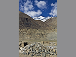 "+
"
"+
"  "+
"
"+
" 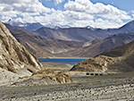 "+
"
"+
" 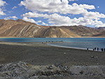 "+
"
"+
"  "+
"
"+
" 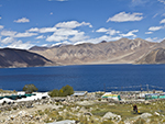 "+
"
"+
" 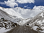 "+
"
"+
" 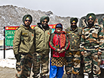 "+
"",
tsokarlakebengali : "সো-করঃ-সো করকে বলা হয় হোয়াইট লেক ও লাদাকে যে তিনটে অতি উচ্চতার নোনা জলের লেক আছে তাদের মধ্যে একটা। একে হোয়াইট লেক বলে, কারণ এই লেকের ধারে সাদা নুনের প্রলেপ জমা হয়ে থাকে। লাদাখের তিনটে গুরুত্বপূর্ণ হ্রদের মধ্যে সো কর লেকটা সবচেয়ে ছোট। লে শহর থেকে প্রায় আড়াইশো কি.মি. দূরে রুপসু উপত্যকায় এর অবস্থান। দক্ষিণ পূর্ব লাদাখের চাংথাং অঞ্চলে অবস্থিত সো করের উচ্চতা ১৫,২৮০ ফুট। লেকটা আর একটা বড় নোনা জলের লেক সো-মরিরি থেকে প্রায় পঞ্চাশ কিলোমিটার দূরে অবস্থিত।সো কর লেক পাখি পর্যবেক্ষণের জন্যে খুবই জনপ্রিয়। লেকের আশেপাশের অঞ্চল বন্যপ্রাণী ও পাখি সমৃদ্ধ। পুরো লেকটাই ঘিরে আছে বিরাট জলাভূমি যেখানে বিচিত্র রকমের পাখির দেখা মেলে, বিশেষত ব্রাহ্মণী হাঁস, বার-হেডেড গুজ ও গ্রেট ক্রেস্টেড গ্রিব ইত্যাদি। তবে পাখির মধ্যে প্রধান আকর্ষণ হল ব্ল্যাক নেকড ক্রেন। জনমানবহীন ও খাদ্য সংগ্রহের সুবিধা থাকার ফলে এখানে তারা ডিম পাড়ে। ছবির মতো মনোরম সবুজ সমতলের প্রেক্ষাপটে, এই পাখিগুলো যখন তুষার ঢাকা পর্বতমালার ওপর দিয়ে ওড়ে তখন এক বিস্ময়কর দৃশ্য সৃষ্টি করে। পক্ষী পর্যবেক্ষণের পাশাপাশি সো-কর বন্যপ্রাণী পর্যবেক্ষকদেরও আকর্ষণ করে। একটু চেষ্টা করলেই দেখা মিলবে বহু সংখ্যায় বর্তমান স্তন্যপায়ী জীব কিয়াংস, যা বুনো গাধার জাতের মধ্যে বৃহত্তম। সো করের চারপাশের পাহাড় পর্বতে অ্যালপাইন আইবেক্স, স্নো ফক্স আর স্নো লেপার্ডেরও বাসস্থান। পাহাড় পর্বত বেষ্টিত, লেকটা নিজেই এক দুর্দান্ত প্রাকৃতিক দৃশ্য সৃষ্টি করেছে, যা ভীষণ রোমান্টিক লাগে সূর্যাস্তের সময়। সো করের দৃশ্য দিনের বেলায় যেমন মনোরম, তেমনই রাতের বেলায় আরও রোমাঞ্চকর হয়ে ওঠে, তবে তা যদি পূর্ণিমা হয় বা চাঁদের আলো থাকে। চাঁদের আলোতে চারপাশের পাহাড়গুলো জ্বলজ্বল করে আর লেকে তাদের ছায়াগুলো মনে হয় সীমাহীন পাহাড়ের এক সমুদ্র। লেকের সম্মোহনী দৃশ্য মনের মণিকোঠায় যে বহুদিন বিরাজমান থাকবে তা একপ্রকার নিশ্চিত। সো কর অঞ্চলে খাম্পাস নামে একটি যাযাবর গোষ্ঠী বাস করে। এরা গ্রীষ্মকালে বড় বড় তাঁবুতে, আর শীতকালে শক্তপোক্ত পাথরের কুঁড়েঘরে বাস করে। এদেরকে বলা হয় চাইনিজ কাউবয় ও পশুপালন এদের মূল জীবিকা। এরা মূলত ইয়াক, ভেড়া, ছাগল ইত্যাদি পালন করে। এরা আবার রূপসা চ্যাং নামে এক যাযাবর জাতি হিসেবেও পরিচিত। এই যাযাবর গোষ্ঠী সো কর থেকে নুন নিয়ে কাছাকাছি অঞ্চলে বিক্রি করে, নিজেদের প্রয়োজনীয় পণ্য সংগ্রহ করে ও এই কাজ তারা অনন্তকাল ধরে করে আসছে। "+
"Read More..."+
"
"+
"",
tsokarlakebengali : "সো-করঃ-সো করকে বলা হয় হোয়াইট লেক ও লাদাকে যে তিনটে অতি উচ্চতার নোনা জলের লেক আছে তাদের মধ্যে একটা। একে হোয়াইট লেক বলে, কারণ এই লেকের ধারে সাদা নুনের প্রলেপ জমা হয়ে থাকে। লাদাখের তিনটে গুরুত্বপূর্ণ হ্রদের মধ্যে সো কর লেকটা সবচেয়ে ছোট। লে শহর থেকে প্রায় আড়াইশো কি.মি. দূরে রুপসু উপত্যকায় এর অবস্থান। দক্ষিণ পূর্ব লাদাখের চাংথাং অঞ্চলে অবস্থিত সো করের উচ্চতা ১৫,২৮০ ফুট। লেকটা আর একটা বড় নোনা জলের লেক সো-মরিরি থেকে প্রায় পঞ্চাশ কিলোমিটার দূরে অবস্থিত।সো কর লেক পাখি পর্যবেক্ষণের জন্যে খুবই জনপ্রিয়। লেকের আশেপাশের অঞ্চল বন্যপ্রাণী ও পাখি সমৃদ্ধ। পুরো লেকটাই ঘিরে আছে বিরাট জলাভূমি যেখানে বিচিত্র রকমের পাখির দেখা মেলে, বিশেষত ব্রাহ্মণী হাঁস, বার-হেডেড গুজ ও গ্রেট ক্রেস্টেড গ্রিব ইত্যাদি। তবে পাখির মধ্যে প্রধান আকর্ষণ হল ব্ল্যাক নেকড ক্রেন। জনমানবহীন ও খাদ্য সংগ্রহের সুবিধা থাকার ফলে এখানে তারা ডিম পাড়ে। ছবির মতো মনোরম সবুজ সমতলের প্রেক্ষাপটে, এই পাখিগুলো যখন তুষার ঢাকা পর্বতমালার ওপর দিয়ে ওড়ে তখন এক বিস্ময়কর দৃশ্য সৃষ্টি করে। পক্ষী পর্যবেক্ষণের পাশাপাশি সো-কর বন্যপ্রাণী পর্যবেক্ষকদেরও আকর্ষণ করে। একটু চেষ্টা করলেই দেখা মিলবে বহু সংখ্যায় বর্তমান স্তন্যপায়ী জীব কিয়াংস, যা বুনো গাধার জাতের মধ্যে বৃহত্তম। সো করের চারপাশের পাহাড় পর্বতে অ্যালপাইন আইবেক্স, স্নো ফক্স আর স্নো লেপার্ডেরও বাসস্থান। পাহাড় পর্বত বেষ্টিত, লেকটা নিজেই এক দুর্দান্ত প্রাকৃতিক দৃশ্য সৃষ্টি করেছে, যা ভীষণ রোমান্টিক লাগে সূর্যাস্তের সময়। সো করের দৃশ্য দিনের বেলায় যেমন মনোরম, তেমনই রাতের বেলায় আরও রোমাঞ্চকর হয়ে ওঠে, তবে তা যদি পূর্ণিমা হয় বা চাঁদের আলো থাকে। চাঁদের আলোতে চারপাশের পাহাড়গুলো জ্বলজ্বল করে আর লেকে তাদের ছায়াগুলো মনে হয় সীমাহীন পাহাড়ের এক সমুদ্র। লেকের সম্মোহনী দৃশ্য মনের মণিকোঠায় যে বহুদিন বিরাজমান থাকবে তা একপ্রকার নিশ্চিত। সো কর অঞ্চলে খাম্পাস নামে একটি যাযাবর গোষ্ঠী বাস করে। এরা গ্রীষ্মকালে বড় বড় তাঁবুতে, আর শীতকালে শক্তপোক্ত পাথরের কুঁড়েঘরে বাস করে। এদেরকে বলা হয় চাইনিজ কাউবয় ও পশুপালন এদের মূল জীবিকা। এরা মূলত ইয়াক, ভেড়া, ছাগল ইত্যাদি পালন করে। এরা আবার রূপসা চ্যাং নামে এক যাযাবর জাতি হিসেবেও পরিচিত। এই যাযাবর গোষ্ঠী সো কর থেকে নুন নিয়ে কাছাকাছি অঞ্চলে বিক্রি করে, নিজেদের প্রয়োজনীয় পণ্য সংগ্রহ করে ও এই কাজ তারা অনন্তকাল ধরে করে আসছে। "+
"Read More..."+
" "+
"",
tsomoririlakebengali : "সো-মরিরিঃ-লাদাখের চাংথাং অঞ্চলে অবস্থিত সো মরিরি লেক ভারতের অন্যতম অতি উচ্চতার এক নোনা জলের লেক। এই লেক খুব সুন্দর, শান্ত, আর লাদাখিদের কাছে অত্যন্ত পবিত্র। পুরোপুরি ভারতীয় উপমহাদেশে অবস্থিত অতি উচ্চতার লেকের মধ্যে এটাই সবথেকে বড়, যার নীল জলের ব্যাপ্তি উনিশ কি.মি. দীর্ঘ ও সাত কি.মি. চওড়া। জলাভূমি রিজার্ভ প্রকল্পের মধ্যে এই লেক রামসার সাইটের অধীনে হওয়ায়, এটা প্রকৃতপক্ষে সো মরিরি জলাভূমি সংরক্ষণ রিজার্ভ নামে পরিচিত। আর সেই নিয়ম অনুযায়ী লেকের কাছাকাছি নির্দিষ্ট এলাকার মধ্যে কেউ কোনও তাঁবু টাঙাতে বা কিছু নির্মাণ করতে পারবে না। এটা বিশ্বের সর্বোচ্চ রামসার সাইট। রামসার সাইট একটা জলাভূমি সাইট যা আন্তর্জাতিক গুরুত্বসম্পন্ন রামসার কনভেনশনে মনোনীত। জলাভূমির ওপর এই কনভেনশনের নাম রামসার কনভেনশন। এটা একটা আন্ত-সরকারি পরিবেশগত চুক্তি যা ১৯৭১ সালে ইউনেস্কো দ্বারা স্থাপিত ও ১৯৭৫ সাল থেকে এটা কার্যকর হয়। জলাভূমি সংরক্ষণের জন্যে জাতীয় তদারকি ও আন্তর্জাতিক সাহায্যের ওপর এই প্রকল্প দাঁড়িয়ে আছে ও জলাভূমি ব্যবহারের জন্য নির্দিষ্ট নীতি ও জলজ প্রাণীদের কোনও রকম ক্ষতি না করে যথাযথ ব্যবহার ও সংস্কারের কথা উল্লেখ আছে। সারা বিশ্বে প্রায় ২,৪০০ রামসার সাইট বর্তমান ও ভারতবর্ষে তার সংখ্যা বিয়াল্লিশ। এই অঞ্চলে প্রচুর পরিমাণে উদ্ভিজ্জ এবং প্রাণীজ উপকরণ পাওয়া যায়। ভারতীয় পর্যটকদের জন্যে সো মরিরি ঘোরার জন্যে কোন ইনারলাইন পারমিট লাগে না। বহু মাত্রার নীল বর্ণের ছায়াছবির সাথে মনোরম প্রাকৃতিক দৃশ্যের পারিপার্শ্বিকতা এই লেকের প্রধান বৈশিষ্ট্য। ফলে দর্শকের কাছে তা অত্যন্ত রোমান্টিক ও গভীরভাবে অনুভবী। কিন্তু বাস্তবে এই স্থান, কাল বিশেষে অত্যন্ত কঠোর, বিশেষত শীতকালে এখানে বেঁচে থাকা কঠিন। লেকের আশেপাশে কেবলমাত্র কয়েকটা আবাসন পাওয়া যায় আর বিদ্যুৎ, চিকিৎসা, গরম জল ইত্যাদি সুবিধা বিরল। অক্সিজেনের অভাব পর্যটকদের বেঁচে থাকা কঠিন করে তোলে, যদি কেউ নিজের শরীরকে অতি উচ্চ উচ্চতার সঙ্গে যথাযথভাবে খাপ খাইয়ে না নিতে পারে। তাই এই রোমান্টিক জায়গার প্রকৃত স্বাদ নিতে গেলে আগে শরীরকে অতি উচ্চতার সঙ্গে সহনশীল করে নিতে হবে। "+
"Read More..."+
"
"+
"",
tsomoririlakebengali : "সো-মরিরিঃ-লাদাখের চাংথাং অঞ্চলে অবস্থিত সো মরিরি লেক ভারতের অন্যতম অতি উচ্চতার এক নোনা জলের লেক। এই লেক খুব সুন্দর, শান্ত, আর লাদাখিদের কাছে অত্যন্ত পবিত্র। পুরোপুরি ভারতীয় উপমহাদেশে অবস্থিত অতি উচ্চতার লেকের মধ্যে এটাই সবথেকে বড়, যার নীল জলের ব্যাপ্তি উনিশ কি.মি. দীর্ঘ ও সাত কি.মি. চওড়া। জলাভূমি রিজার্ভ প্রকল্পের মধ্যে এই লেক রামসার সাইটের অধীনে হওয়ায়, এটা প্রকৃতপক্ষে সো মরিরি জলাভূমি সংরক্ষণ রিজার্ভ নামে পরিচিত। আর সেই নিয়ম অনুযায়ী লেকের কাছাকাছি নির্দিষ্ট এলাকার মধ্যে কেউ কোনও তাঁবু টাঙাতে বা কিছু নির্মাণ করতে পারবে না। এটা বিশ্বের সর্বোচ্চ রামসার সাইট। রামসার সাইট একটা জলাভূমি সাইট যা আন্তর্জাতিক গুরুত্বসম্পন্ন রামসার কনভেনশনে মনোনীত। জলাভূমির ওপর এই কনভেনশনের নাম রামসার কনভেনশন। এটা একটা আন্ত-সরকারি পরিবেশগত চুক্তি যা ১৯৭১ সালে ইউনেস্কো দ্বারা স্থাপিত ও ১৯৭৫ সাল থেকে এটা কার্যকর হয়। জলাভূমি সংরক্ষণের জন্যে জাতীয় তদারকি ও আন্তর্জাতিক সাহায্যের ওপর এই প্রকল্প দাঁড়িয়ে আছে ও জলাভূমি ব্যবহারের জন্য নির্দিষ্ট নীতি ও জলজ প্রাণীদের কোনও রকম ক্ষতি না করে যথাযথ ব্যবহার ও সংস্কারের কথা উল্লেখ আছে। সারা বিশ্বে প্রায় ২,৪০০ রামসার সাইট বর্তমান ও ভারতবর্ষে তার সংখ্যা বিয়াল্লিশ। এই অঞ্চলে প্রচুর পরিমাণে উদ্ভিজ্জ এবং প্রাণীজ উপকরণ পাওয়া যায়। ভারতীয় পর্যটকদের জন্যে সো মরিরি ঘোরার জন্যে কোন ইনারলাইন পারমিট লাগে না। বহু মাত্রার নীল বর্ণের ছায়াছবির সাথে মনোরম প্রাকৃতিক দৃশ্যের পারিপার্শ্বিকতা এই লেকের প্রধান বৈশিষ্ট্য। ফলে দর্শকের কাছে তা অত্যন্ত রোমান্টিক ও গভীরভাবে অনুভবী। কিন্তু বাস্তবে এই স্থান, কাল বিশেষে অত্যন্ত কঠোর, বিশেষত শীতকালে এখানে বেঁচে থাকা কঠিন। লেকের আশেপাশে কেবলমাত্র কয়েকটা আবাসন পাওয়া যায় আর বিদ্যুৎ, চিকিৎসা, গরম জল ইত্যাদি সুবিধা বিরল। অক্সিজেনের অভাব পর্যটকদের বেঁচে থাকা কঠিন করে তোলে, যদি কেউ নিজের শরীরকে অতি উচ্চ উচ্চতার সঙ্গে যথাযথভাবে খাপ খাইয়ে না নিতে পারে। তাই এই রোমান্টিক জায়গার প্রকৃত স্বাদ নিতে গেলে আগে শরীরকে অতি উচ্চতার সঙ্গে সহনশীল করে নিতে হবে। "+
"Read More..."+
"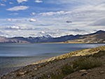 "+
"
"+
" 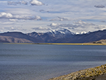 "+
"
"+
" 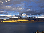 "+
"
"+
" 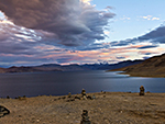 "+
"
"+
" 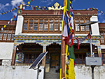 "+
"
"+
" 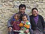 "+
"
"+
" 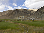 "+
"
"+
" 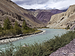 "+
"",
headingbengali : "লাদাখ",
headingenglish : "LADAKH",
};
"+
"",
headingbengali : "লাদাখ",
headingenglish : "LADAKH",
};