var Himachalplaces =
{
menusystembengali :
" "+
"এই পাতার জায়গাসমূহঃ-"+
"মেনু দেখতে ক্লিক করুন"+
" •চাম্বা"+
" •ডালহাউসি "+
" •ধরমশালা "+
" •কাংড়া-ভ্যালি",
menusystemenglish :
" "+
"Places in This Page:-"+
"Click To See Menu"+
" •Chamba"+
" •Dalhousie "+
" •Dharamsala "+
" •Kangra-Valley",
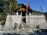
chambabengali : "চাম্বাঃ-চাম্বার ইতিহাস:- চাম্বা উত্তর ভারতের একমাত্র রাজ্য যেখানে প্রায় ৫০০ সাল থেকে আজ অব্দি একটা ভাল-নথিভুক্ত ইতিহাস সংরক্ষণ করা হয়। এই রাজ্যের উচ্চ পর্বতশ্রেণী এখানকার শতাব্দী প্রাচীন ধ্বংসাবশেষ এবং অসংখ্য শিলালিপি সংরক্ষণে সাহায্য করেছে। এক হাজার বছরেরও বেশি পুরোনো চাম্বার রাজাদের দ্বারা নির্মিত মন্দিরগুলো এখনও উপাসনা স্থল হিসেবে বিবেচিত ও তাদের দ্বারা তামার প্লেটে সম্পাদিত জমি অনুদান কাজ আজও আইনে বৈধ বলে অব্যাহত রয়েছে।এই অঞ্চলের প্রাথমিক ইতিহাস সম্পর্কে এটা বিশ্বাস করা হয় যে, এই অঞ্চলে কিছু কোলিয়ান উপজাতির বসবাস ছিল, যা পরবর্তীতে খাসাদের নিয়ন্ত্রণে আসে। খাসরাও খ্রিস্টপূর্ব দ্বিতীয় শতাব্দীতে অদুম্বরসের অধীনে আসে। অদুম্বরস সরকারের একটা প্রজাতন্ত্রী গঠন ছিল এবং তারা শিবকে তাদের প্রধান দেবতা হিসাবে পুজো করতো। চতুর্থ শতাব্দীতে গুপ্ত যুগ থেকে চাম্বা অঞ্চল ঠাকুর এবং রাণাদের নিয়ন্ত্রণে আসে, যারা নিজেদেরকে নিম্ন উপজাতিদের কোলি ও খাসদের থেকে উঁচু জাতের বলে মনে করতো। সপ্তম শতাব্দীতে গুর্জর প্রতিহারের উত্থানের সাথে সাথে রাজপুত রাজবংশ ক্ষমতায় আসে। আনুমানিক ৫০০ সালে মারু নামে একজন কিংবদন্তি নায়ক কল্পগ্রাম থেকে উত্তর-পশ্চিমে বর্তমান চাম্বার ৭৫ কিমি পূর্বে বুধিল নদীর উপত্যকায় ব্রহ্মপুরা বা বর্তমান ভারমোর প্রতিষ্ঠা করেন। কল্পগ্রাম একটা পৌরাণিক স্থান, যেখান থেকে বেশিরভাগ রাজপুত রাজবংশের সৃষ্টি বলে দাবি করা হয়। তাঁর উত্তরসূরিরা সেই রাজধানী শহর থেকে তিনশ বছরেরও বেশি সময় ধরে দেশ শাসন করতে থাকেন যতক্ষণ না সাহিল্লা বর্মণ তার রাজধানী ব্রহ্মপুরা থেকে নিম্ন রাভি উপত্যকার কেন্দ্রে অবস্থিত মালভূমিতে স্থানান্তরিত করেন। তিনি তার প্রিয় কন্যা চম্পার নামে শহরের নামকরণ করেন। তার রানী স্বেচ্ছায় নিজেকে উৎসর্গ করেন ও শহরের মানুষের জন্যে ভালোটা নামে একটা জায়গা থেকে জল আনার চ্যানেল তৈরি করেন। চাম্বার পরিকল্পনার বিন্যাস প্রাচীন গ্রন্থের সাথে সামঞ্জস্যপূর্ণ বলে মনে করা হয়। সেই থেকে চাম্বার রাজারা ও তাদের বংশধররা, এখান থেকে নিরবচ্ছিন্নভাবে রাজত্ব করতে থাকে। রাজা সহিল্লা বর্মণ দৃশ্যপটে আসার আগে, চাম্বা অঞ্চলকে বলা হতো রাহনু। এই এলাকা ছোট ছোট ভাগে বিভক্ত ছিল, ও অসংখ্য রানা এবং ক্ষুদে সেনাপতিরা এই অংশে রাজ করতো, যারা একে অপরের সাথে নিরলস যুদ্ধ চালিয়েছিল। রাজা সহিল্লা বর্মণ রানাদের পরাজিত করে এই অঞ্চলকে একীভূত করেন। রাজা সহিল্লা বর্মণ উন্নত প্রশাসনের জন্যে চাম্বাকে মণ্ডল নামে পাঁচটা অঞ্চলে বিভক্ত করেন। এই মণ্ডলদের পরবর্তীতে উইজারত নামে নামকরণ করা হয়। চাম্বা অঞ্চলের এই পাঁচটা বিভাজন আজ অবধি অব্যাহত রয়েছে। উইজারতদের এখন তহসিল বলা হয়। এগুলো হল ভারমোর, চাম্বা, ভাটিয়াত, চুরাহ এবং পাঙ্গি।মুসলমানরা কখনোই চাম্বা আক্রমণ করেনি, যদিও একই ধরনের সাংস্কৃতিক পটভূমি সম্পন্ন পাহাড়ের প্রতিবেশী রাজ্যগুলোর সাথে মাঝে মাঝেই লড়াই হয়েছে। এই আক্রমণগুলো থেকে চাম্বার ক্ষতি খুব কমই হতো ও তা সহজেই মেরামত করা যেত। এমনকি শক্তিশালী মুঘলরাও, দীর্ঘ দূরত্ব ও যোগাযোগের অভাবে, চাম্বা আক্রমণ থেকে বিরত থাকতেন। আকবর চাম্বা সহ পার্বত্য রাজ্যগুলোর উপর একটি হালকা নিয়ন্ত্রণ রাখার চেষ্টা করেছিলেন, এবং ধৌলাধারের দক্ষিণে এই রাজ্যগুলোর উর্বর অঞ্চলগুলোকে নিজের সাম্রাজ্যের সাথে যুক্ত করেছিলেন। আওরঙ্গজেব একবার চাম্বার রাজা ছত্র সিংকে (১৬৬৪ থেকে ১৬৯৪) চাম্বার সুন্দর মন্দিরগুলোকে ভেঙে ফেলার আদেশ জারি করেছিলেন। কিন্তু এর পরিবর্তে রাজা মুঘল শাসকের আদেশ স্পষ্ট অমান্য করেন ও মন্দিরের উপর চূড়া নির্মাণ করেন। মুঘল সম্রাটের আদেশ অমান্য করার জন্যে তাঁকে জন্য তাকে দিল্লিতে দেখা করার নির্দেশ দেওয়া হয়েছিল। কিন্তু আওরঙ্গজেব নিজেই দাক্ষিণাত্যের উদ্দেশে রওনা হন, ও তিনি জীবনের শেষ অবধি সেই সমস্যা মীমাংসা করতে পারেননি। সামগ্রিকভাবে, মুঘল শাসনকালে উত্তর ভারত তুলনামূলকভাবে শান্তিপূর্ণ ছিল। রাজা পৃথ্বী সিং (১৬৪১ থেকে ১৬৬৪ খ্রিস্টাব্দ) একজন সুদর্শন এবং বীর নাইট, শাহজাহানের অত্যন্ত প্রিয় ছিলেন এবং বহুবার মুঘল রাজদরবারে গিয়েছিলেন। তিনি চাম্বাতে মুঘল দরবারী শাসনব্যবস্থা ও মুঘল-রাজপুত শৈলীর বিভিন্ন স্থাপত্য প্রবর্তন করেন।অষ্টাদশ শতাব্দীর শেষভাগে শিখরা পার্বত্য রাজ্যগুলিকে তাদের শ্রদ্ধা জানাতে বাধ্য করেছিল। মহারাজা রঞ্জিত সিং, কাংড়া শাসক সংসার চাঁদ কাটোচ সহ সমস্ত পাহাড়ি শাসকদের ক্ষমতাচ্যুত করেছিলেন, কিন্তু চাম্বার ওয়াজির নাথু তাঁকে দুটো অনুষ্ঠানে পরিষেবা দিয়ে চাম্বাকে রক্ষা করেছিলেন। ১৮০৯ সালে ওয়াজির কাংড়ার রাজা সংসার চাঁদ কাটচের সাথে রঞ্জিত সিংয়ের চুক্তির মাধ্যমে, নিজেকে মহারাজরা আস্থাভাজন করে তুলেছিলেন। আবার ১৮১৭ খ্রিস্টাব্দে তিনি কাশ্মীরে শীতকালীন অভিযানের সময় একটা জটিল মুহূর্তে, তাঁর ঘোড়া দিয়ে সাহায্য করে, রঞ্জিত সিংয়ের জীবন রক্ষা করেছিলেন। রঞ্জিত সিংয়ের মৃত্যুর পর চাম্বা অরক্ষিত হয়ে পড়ে এবং শিখ রাজ্য বিচ্ছিন্নতার ঘূর্ণিতে আটকে যায়। ১৮৪৫ সালে সালে যখন শিখ সেনাবাহিনী ব্রিটিশ ভূখণ্ড আক্রমণ করেছিল, তখন শিখ সেনাবাহিনীর যে সৈন্যরা চাম্বাতে অবস্থান করেছিল, তাদেরকেও ডেকে নেওয়া হয়। শিখরা পরাজিত হলে, চাম্বাকে জম্মু ও কাশ্মীরের সাথে একীভূত করার সিদ্ধান্ত নেওয়া হয়। কিন্তু চাম্বার ওয়াজির বাঘার সময়মত হস্তক্ষেপের কারণে, বার্ষিক ১২,০০০ টাকা সম্মানীর বিনিময়ে, চাম্বা ব্রিটিশ নিয়ন্ত্রণে থেকে যায়। যে রাজারা ব্রিটিশ আধিপত্যের কিছু দেখেছিলেন তারা হলেন শ্রী সিং, গোপাল সিং, শাম সিং, ভূরি সিং, রাম সিং এবং লক্ষ্মণ সিং। ব্রিটিশ রাজনৈতিক অফিসারদের সাথে তাদের সম্পর্ক সৌহার্দ্যপূর্ণ ছিল বলে মনে করা হয় এবং তখন চাম্বা অনেক সংস্কারের সাক্ষী ছিল। ১৯৪৮ সালের ১৫ এপ্রিল তিনটি প্রধান রাজ্য চাম্বা, মাণ্ডি-সুকেত ও সিরমোর এবং সিমলা পাহাড়ে অবস্থান করে এ রকম অন্যান্য সমস্ত রাজ্য একীভূত করে ইউনিয়ন টেরিটরি হিমাচল গঠিত হয়। ১৯৭১ সালে হিমাচল প্রদেশ রাজ্য হিসেবে মর্যাদা লাভ করে।লক্ষ্মীনারায়ণ মন্দিরঃ-দশম শতাব্দীতে সাহিল বর্মণ লক্ষ্মী নারায়ণ মন্দির তৈরি করেন, যেটি চাম্বা শহরের প্রধান মন্দির হিসেবে আজও বিখ্যাত। মন্দিরটা শিখর শৈলীতে নির্মিত হয়েছে। মন্দিরটা শিখর এবং একটি ছোট গর্ভগৃহ নিয়ে গঠিত। লক্ষ্মী নারায়ণ মন্দিরে মণ্ডপের মতো কাঠামোও রয়েছে। তুষারপাতের বিরুদ্ধে সুরক্ষা হিসাবে ও স্থানীয় জলবায়ু পরিস্থিতির মোকাবিলা হিসাবে মন্দিরের উপরে কাঠের ছত্রী ও চাকার আকারের ঢালু ছাদ রয়েছে। এই কমপ্লেক্সের মধ্যে আরও কয়েকটা মন্দির রয়েছে। ১৮২৫ সালের শেষের দিকে রাজা জিত সিংয়ের রানী রাণা সারদা রাধা কৃষ্ণ মন্দির তৈরি করেন। চন্দ্রগুপ্ত শিব মন্দিরটা তৈরি করেন সাহিল বর্মণ ও গৌরী শঙ্কর মন্দির নির্মাণ করেন তাঁর পুত্র এবং উত্তরসূরি যুগকর বর্মণ। লক্ষ্মী নারায়ণের মন্দির চাম্বার সিংহাসনে অধিষ্ঠিত সমস্ত রাজাদের সাহায্য ও সহযোগিতা পেত। রাজা বলভদ্র ভার্মা মন্দিরের প্রধান ফটকের একটা উঁচু স্তম্ভে গরুড়ের একটা ধাতব মূর্তি স্থাপন করেছিলেন। ১৬৭৮ সালে আওরঙ্গজেবের মন্দির ভেঙে ফেলার আদেশের বিরুদ্ধে প্রতিক্রিয়া হিসেবে, রাজা ছত্র সিং মন্দিরের মাথায় একটা সোনার চূড়া স্থাপন করেন। পরবর্তীকালে অন্য রাজারাও একটা বা দুটো মন্দির যোগ করে এই মন্দির কমপ্লেক্সকে সমৃদ্ধ করেন।ভূরি সিং মিউজিয়ামঃ- ১৪ সেপ্টেম্বর ১৯০৮ সালে আনুষ্ঠানিকভাবে ভূরি সিং মিউজিয়াম উদ্বোধন করা হয়। এটা রাজা ভূরি সিংয়ের নামে নামকরণ করা হয়েছে যিনি ১৯০৪ থেকে ১৯১৯ সাল পর্যন্ত চাম্বা শাসন করেছিলেন। ভূরি সিং তাঁর পারিবারিক চিত্রকর্মের সংগ্রহ জাদুঘরে দান করেছিলেন। সর্বজনীন জাদুঘর খোলার ধারণা ভূরি সিং, জে পি এইচ ভোগলের কাছ থেকে পেয়েছেন। ভোগলে একজন প্রখ্যাত ভারততত্ত্ববিদ যিনি আরকিওলজিক্যাল সার্ভে অফ ইণ্ডিয়ায় কাজ করতেন ও একটি নিবিড় অন্বেষণের মাধ্যমে চাম্বা রাজ্যের ভূখণ্ডে দূর দূরান্তে ছড়িয়ে ছিটিয়ে থাকা পুরানো শিলালিপিগুলি আবিষ্কার, পাঠ এবং বিশ্লেষণ করেছিলেন। সারদা লিপির এই শিলালিপিগুলো চাম্বার মধ্যযুগীয় ইতিহাসের উপর গুরুত্বপূর্ণ আলোকপাত করেছে। সারাহান, দেবী-রি-কোঠি এবং মুল কিহারের শিলালিপিগুলো এখন ভূরি সিং মিউজিয়ামে সংরক্ষণ করা আছে। অদ্ভুত শৈলীতে ভাগবত পুরাণ এবং রামায়ণের চিত্রগুলো, চিত্রকলার বসোহলি বাগধারা অনুযায়ী নির্মিত যেখানে কৃষ্ণ, সুদামা, রুক্মিণী বিভা এবং উষা অনিরুদ্ধ গুলের-কাংড়া শৈলীতে গঠিত ও তা চাম্বা শাসকদের পৃষ্ঠপোষকতা প্রদানকারী শিল্পীদের দ্বারা সম্পাদিত হয়েছিল। সূচিকর্ম করা চাম্বা-রুমালগুলো চাম্বা শৈলীর সাথে সম্পর্কিত কারণ তা পাহাড়ি চিত্রশিল্পীদের দ্বারা আঁকা ও সূচিকর্মের কাজ করেছিলেন বাড়ির মহিলারা।সংগ্রহের এই প্রধান আইটেমগুলি ছাড়াও, রয়েছে মুদ্রা, পাহাড়ি গয়না, ঐতিহ্যবাহী এবং রাজকীয় পোশাক, অস্ত্র ও বর্ম, বাদ্যযন্ত্র এবং বিভিন্ন আলংকারিক বস্তু।পুরোনো মিউজিয়াম ভবন যেটা নষ্ট হয়ে গেছিল, তা ভেঙে ফেলে বর্তমানে কংক্রিটের মিউজিয়াম তৈরি করা হয়েছে ও ১৯৭৫ সালে উদ্বোধন করা হয়েছিল। মিউজিয়াম সোমবার এবং অন্যান্য গেজেটেড ছুটির দিন ছাড়া সারা বছর সকাল দশটা থেকে বিকেল পাঁচটা পর্যন্ত খোলা থাকে। এন্ট্রি ফি ১০০ টাকা হলেও তাতে দুজনকে প্রবেশ করতে দেয়।চামুণ্ডা দেবী মন্দিরঃ-চামুণ্ডা দেবী মন্দির, পাহাড়ের শাহ মাদার রেঞ্জের ঢালে এবং চাম্বা শহরের বিপরীতে একটা দৃষ্টিনন্দন স্থানে অবস্থিত। এটা তীর্থযাত্রীদের জন্য একটা প্রধান পবিত্র স্থান যা বানের নদীর তীরে অবস্থিত। ১৭৬২ সালে রাজা উমেদ সিং মন্দিরটা নির্মাণ করেন। এটা চাম্বার কাঠের ছাদযুক্ত একমাত্র মন্দির। আগে, মন্দিরে যেতে গেলে ৩৭৮টা সিঁড়িযুক্ত পাথরের খাড়া পথ দিয়ে য়েতে হতো কিন্তু বর্তমানে যাত্রীরা গাড়ি নিয়ে পাকা রাস্তায় চাম্বা থেকে মাত্র তিন কিমি গেলেই পৌঁছাতে পারেন। এখান থেকে পাথিয়ার এবং লাহলার ঘন বন দেখতে পাওয়া যায় যা এখানকার অন্যতম পর্যটন আকর্ষণ। মন্দির থেকে পাহাড়ের নীচে অবস্থিত চাম্বা জনপদেরও একটা মনোমুগ্ধকর দৃশ্য দেখা যায়। এই মন্দির দেবী কালীর উদ্দেশ্যে উৎসর্গ করা হয়েছে, যিনি যুদ্ধের দেবী হিসেবে পরিচিত। গর্ভগৃহের অভ্যন্তরভাগ খোদাইকৃত রুপোর চাদরে অলঙ্কৃত। মন্দিরের স্থাপত্য বেশ সহজ এবং শান্ত কিন্তু ধর্মীয় প্রভাব অপ্রতিরোধ্য। এখানে ফুলের থিম এবং বিভিন্ন সুন্দর খোদাই মূর্তি রয়েছে, যা চাম্বা উপত্যকা এবং হিমালয় পর্বতমালার মনোমুগ্ধকর দৃশ্যগুলোর সাথে খুবই সামঞ্জস্যপূর্ণ। নবরাত্রির সময়, সারা ভারত চামুণ্ডা দেবীর আশীর্বাদ পেতে এখানে আসেন।ইতিহাস:-কিংবদন্তি অনুসারে, দেবী অম্বিকা যখন পাহাড়ের চূড়ায় বসেছিলেন, তখন চন্দ ও মুণ্ডা নামে দুই শয়তান তাকে বিরক্ত করার চেষ্টা করেছিল ও তিনি অত্যন্ত রেগে গেছিলেন। তখন তাঁর ভ্রু থেকে বাঘের চামড়া পরিহিত শাড়ি ও গলায় নরমুণ্ডমালার মালা সজ্জিত দেবী কালী এসেছিলেন দুই রাক্ষসকে হত্যা করার জন্য। তাদের হত্যা করার পর দেবী অম্বিকা ঘোষণা করেছিলেন যে এখানে দেবী কালী এখন চামুণ্ডা দেবী হিসাবে পূজিত হবেন। মন্দিরে একটা ট্যাঙ্ক রয়েছে যা ভক্তরা স্নানের জন্য ব্যবহার করেন। মন্দিরের পিছনের দিকে গুহার মতো একটা জায়গা রয়েছে, যেখানে একটা পাথরের শিবলিঙ্গ রাখা আছে। সেখানে অবশ্য অন্যান্য দেবতার মূর্তিও আছে। "+
"Read More..."+
"
"+
"শব্দঃ প্রতিবেদনঃ "+
""+
"ভিডিও"+
"স্লাইডশোর জন্যে নীচের ছবিতে ক্লিক করুন "+
"
"+
"পেজ মেনুতে যান",
chambaenglish : "Chamba:-History of Chamba:-Chamba is the only place in northern India where a well-documented history has been preserved since 500 years to date. The state's high mountain ranges have helped preserve centuries-old ruins and numerous inscriptions. The temples built by the Chamba kings which are more than a thousand years old, still considered places of worship and the land grant work performed by them on copper plates continues to be legal today.The early history of the region is believed to have been inhabited by some Kolian tribes, who later came under the control of the Khasas. The Khasas also came under Adumbars in the second century BC. The Adumbaras government had a republican structure and they worshiped Shiva as their main deity. From the Gupta period in the 4th century, the Chamba region came under the control of the Thakurs and Ranas, who considered themselves superior to the Koli and Khas of the lower tribes. The Rajput dynasty came to power with the rise of Gurjar Pratihara in the 7th century.In about year 500, a legendary hero named Maru established Brahmapura, or present-day Vermor, in the valley of the river Budhil, 75 km east of the present Chambar and northwest of Kalpagram. Kalpagram is a mythical place from which most of the Rajput dynasties are claimed to have originated. His successors ruled the country from that capital city for more than three hundred years until Sahilla Varman shifted his capital from Brahmapura to the plateau in the centre of the Lower Ravi Valley. He named the town after his beloved daughter Champa. His queen volunteered herself and created a channel for the people of the town to fetch water from a place called Bhalota. The layout of the chamber plan is thought to be consistent with the ancient texts. From then on, the Chamba kings and their descendants continued to rule uninterruptedly. Before King Sahilla Varman came on the scene, Chamba region was called Rahnu. The area was divided into smaller parts, and was ruled by numerous ranas and petty generals who fought relentlessly against each other. King Sahilla Varman unified the region by defeating the Ranas. King Sahilla Varman divided Chamba into five regions called Mandal for better administration. These zones were later renamed Wizarats. These five divisions of the Chamba region continue even today. Wizarats are now called tehsils. These are Vermore, Chamba, Bhatiat, Churah and Pangi.The Muslims have never attacked Chamba, although there have been occasional skirmishes with neighbouring hill states with similar cultural backgrounds. The damage from these attacks was minimal and could be easily repaired. Even the powerful Mughals, due to long distance and lack of communication, refrained from attacking Chamba. Akbar tried to maintain a light control over the hill states, including Chamba, and annexed the fertile areas of these states, south of Dhauladhar, to his empire. Aurangzeb once ordered Chhatra Singh (1664 to 1694), the king of Chamba, to demolish the beautiful temples of Chamba. But instead, the king clearly disobeyed the orders of the Mughal ruler and built a pinnacle on the temple. He was ordered to meet him in Delhi for disobeying the orders of the Mughal emperor. But Aurangzeb himself set out for the Deccan, and he could not resolve the issue until the end of his life. Overall, North India was relatively peaceful during the Mughal rule. King Prithvi Singh (1641 to 1664 AD) was a handsome and valiant knight, very dear to Shah Jahan and visited the Mughal court many times. He introduced the Mughal court system and various Mughal-Rajput style architecture in Chamba.Towards the end of the eighteenth century, the Sikhs forced the hill states to pay their respects. Maharaja Ranjit Singh deposed all the hill rulers, including the Kangra ruler Sansar Chand Katoch, but Wazir Nathu saved Chamba by serving him on two occasions. In 1809, through the treaty of Ranjit Singh with Chand Katch, the king of Kangra, Wazir made himself trustworthy to maharajas. In 1817, he saved Ranjit Singh's life by helping him with his horse at a critical moment during a winter expedition to Kashmir. After the death of Ranjit Singh, Chamba became unprotected and the Sikh kingdom was caught in a whirlpool of isolation. When the Sikh army invaded British territory in 1845, the soldiers of the Sikh army stationed at Chamba were also called up. When the Shikhas were defeated, it was decided to merge Chamba with Jammu and Kashmir. But due to the timely intervention of Wazir Bagha, Chamba remained under British control for an annual honorarium of 12,000 rupees. The kings who saw some of the British domination were Sri Singh, Gopal Singh, Sham Singh, Bhuri Singh, Ram Singh and Lakshman Singh. Their relations with British political officials were considered cordial and Chamba witnessed many reforms at that time. On 15 April 1948, the three main states of Chamba, Mandi-Suket and Sirmore and the Shimla Hills merged to form the Union Territory of Himachal Pradesh. Himachal Pradesh became a state in 1971.Laxminarayan Temple:-Sahil Varman built Lakshmi Narayan Temple in the 10th century, which is still famous as the main temple of Chamba town. The temple is built in Shikhar style. The temple consists of a spire and a small sanctum sanctorum. The Lakshmi Narayan Temple also has a mandapa-like structure. The temple has a wooden canopy and a wheel-shaped sloping roof over the temple as protection against frost and to cope with the local climate. There are a few more temples in this complex. Towards the end of 1825, queen Rana Sarda of King Jeet Singh, built Radha Krishna temple. The Shiva temple Chandragupta, was built by Sahil Varman and Gauri Shankar Mandir was built by his son and successor Yugakar Varman. Lakshmi Narayan temple received the help and support of all the kings sitting on the throne of Chamba. King Balbhadra placed a metal statue of an eagle on a high pillar at the main gate of the Verma temple. In response to Aurangzeb's order to demolish the temple in 1678 AD, Raja Chhatra Singh placed a gold pinnacle on top of the temple. Later other kings also enriched the temple complex by adding one or two temples.Bhuri Singh Museum:-Bhuri Singh Museum was officially inaugurated on 14th September 1908. It is named after Raja Bhuri Singh who ruled Chamba from 1904 to 1919. Bhuri Singh donated his collection of family paintings to the museum. Bhuri Singh got the idea of opening a public museum from J P H Vogle. Vogle is an eminent Indian theologian, who worked on the Archaeological Survey of India, and by his through and intensive search, he discovered, read and analyzed the old inscriptions, scattered far and wide in the territory of the state of Chamba. These inscriptions in the Sarada script, shed important light on the medieval history of Chamba. The inscriptions of Sarahan, Devi-ri-kothi and Mul Kihar are now preserved in the Bhuri Singh Museum. The Bhagavata Purana and Ramayana paintings in a bizarre style are based on the Basohali idiom of painting where Krishna, Sudama, Rukmini Viva and Usha Aniruddha are made in the Gul-Kanga style and were originated by artists who were patronized by the Chamba rulers. The embroidered Chamba-handkerchiefs are related to the Chamba style, because they were painted by painters residing in hills and embroidered by housewives.In addition to these main items of collection, there are coins, jewellery used by hilly habitats, traditional and royal attire, weapons and armour, musical instruments and various decorative items.The old museum building, which was dilapidated, has been demolished to make way for a concrete museum, which was inaugurated in 1975. The museum is open from 10 am to 5 pm, all year round, except Mondays and other gazetted holidays. Although the entry fee is rupees 100, it allows two people to enter.Chamunda Devi Temple:-Chamunda Devi Temple is located on the slopes of the Shah Mother hilly Range in a scenic spot opposite to the town of Chamba. It is a major holy place for pilgrims located on the banks of the river Baner. The temple was built in 1762 by King Umed Singh. It is the only temple with a wooden roof in Chamba. In the past, one had to take a 378 stone step path to reach the temple, but now travellers can reach the temple only 3 km riding by car from Chamba. The dense forests of Pathiar and Lahla can be seen from here which is one of the tourist attractions here. The temple also offers a breath-taking view of the Chamba town at the foot of the hill. This temple is dedicated to the goddess Kali, who is known as the goddess of war. The interior of the sanctum sanctorum is decorated with engraved silver sheets. The architecture of the temple is quite simple and serene but the religious influence is irresistible. There are floral themes and various beautiful carvings, which are in perfect harmony with the stunning views of the Chamba Valley and the Himalayas. During Navratri, people from all over India come here to seek the blessings of Goddess Chamunda.History:-According to the legend, when the goddess Ambika was sitting on the top of the hill, two devils named Chanda and Munda tried to annoy her and she became very angry. Then Goddess Kali came from her eyebrows wearing a tiger skin sari and a necklace of human skull around her neck to kill the two demons. After killing them, Goddess Ambika announced that Goddess Kali would now be worshiped here as Goddess Chamunda. The temple has a tank which devotees use for bathing. At the back of the temple there is a cave-like place where a stone Shivling is kept. There are, of course, idols of other gods also. "+
"Read More..."+
"
"+
"Sound Stream: "+
""+ "Video"+
"Click any Picture for Slide Show "+
"
"+
"Go To Page Menu",
photochamba :
""+
" "+
" "+
" "+
" "+
" "+
" "+
" "+
""+
"",
dalhousiebengali : "ডালহাউসিঃ-চাম্বা জেলার ডালহাউসি হল ঔপনিবেশিক আকর্ষণে পূর্ণ একটা হিল স্টেশন যেখানে ব্রিটিশরাজের দীর্ঘস্থায়ী প্রতিধ্বনি রয়েছে। কাথলগ পোট্রে, তেহরা, বাক্রোটা ও বলুন, এই পাঁচটা পাহাড় দিয়ে বিস্তৃত শহরটার নামকরণ করা হয়েছে, ঊনবিংশ শতাব্দীর ব্রিটিশ গভর্নর জেনারেল লর্ড ডালহৌসির নামে। উঁচু নিচু শহরটার বিভিন্ন উচ্চতায় বিভিন্ন ধরনের গাছ ও ফুল রয়েছে। যেমন পাইন, দেবদারু, ওক এবং ফুলের মধ্যে নানা রঙের রডোডেনড্রন। ঔপনিবেশিক স্থাপত্যে সমৃদ্ধ, শহরটাতে কিছু সুন্দর গির্জা রয়েছে। এর বিস্ময়কর পায়ে চলা পথে দেখতে পাওয়া যায় জলপ্রপাত, ঝর্ণা এবং ছোট ছোট নদী। সর্পিল পাহাড়ি পথের বাঁকে বাঁকে রয়েছে অপূর্ব সুন্দর রাভি নদীর দৃশ্যাবলী। এছাড়াও রয়েছে চাম্বা উপত্যকা এবং দিগন্ত বিস্তৃত ধৌলাধার রেঞ্জের বিস্ময়কর তুষার আচ্ছাদিত শিখরগুলোর মনোরম দৃশ্য। জায়গায় জায়গায় তিব্বতি সংস্কৃতির ছোঁয়া গোটা পরিবেশকে করেছে নির্মল ও পবিত্র। ডালহাউসির সবথেকে কাছের রেলস্টেশন হচ্ছে পাঠানকোট যা প্রায় ৮৫ কিলোমিটার দূরে অবস্থিত।কালাটপঃ- ডালহৌসি এবং খাজ্জিয়ারের মাঝখানে অবস্থিত, কালাটপ একটা সুন্দর বনাঞ্চল। এটা একটা খুব ঘন এবং অন্ধকার জঙ্গল যা পাহাড়ের চূড়ার মুকুটের মতো অবস্থান করছে এবং সম্ভবত সেই কারণেই স্থানটার নাম কালাটপ হয়েছে। এখান থেকে আশেপাশের প্রাকৃতিক দৃশ্য অসাধারণ। দেখা যাবে সুদূর প্রসারিত তরঙ্গায়িত পাহাড়ের ঢাল, তুষারাবৃত পর্বতমালা, সবুজ উপত্যকা, পাহাড়ের বুকে ছোট ছোট ফুলের মতো ফুটে থাকা গ্রাম, সবুজের থেকে সবুজ বনাঞ্চল আর অনন্য রুক্ষতা। কালাটপ বনাঞ্চল প্রধানত দেবদারু, কাইল, স্প্রুস, বান ইত্যাদি গাছ এবং বন্য প্রাণীদের জন্য নিরাপদ আবাস প্রদানকারী বিভিন্ন ঝোপের সমন্বয়ে গঠিত। জায়গাটাকে সরকার ইতিমধ্যেই বন্যপ্রাণীর অভয়ারণ্য হিসেবে ঘোষণা করেছে। তিতির, মোনাল এবং অন্যান্য বিভিন্ন পাখি এই জায়গায় প্রায়শই দেখা যায়। চিতাবাঘ, কালো ভাল্লুকও ভ্রমণকারীরা মাঝে মাঝে দেখতে পান। এখানে থাকার জন্যে বনবাংলো ছাড়াও কিছু হোমস্টে আছে। তবে সেখানে সন্ধেবেলা থেকে ঘরের বাইরে বেরোনো নিষেধ।ডাইনকুণ্ড পিক:-ডালহৌসি বাস স্ট্যান্ড থেকে ১৭ কিলোমিটার দূরে, ২,৭৫৫ মিটার উচ্চতায় অবস্থিত ডাইনকুণ্ড পিক, ডালহৌসির সর্বোচ্চ পর্বতশৃঙ্গ। এটা ডালহাউসির সবচেয়ে গুরুত্বপূর্ণ চূড়া এবং খুব জনপ্রিয় পর্যটন স্থান। পর্যটকরা এই শিখর থেকে সমগ্র উপত্যকার ৩৬০° দৃশ্য উপভোগ করেন। ডালহৌসির কাছে সংক্ষিপ্ত ট্রেকিংয়ের জন্যেও ডাইনকুণ্ড খ্যাত। ডাইনকুণ্ড নামটা ডাইন কুণ্ড থেকে উদ্ভূত হয়েছে বলে জানা যায়, যার অর্থ ডাইনিদের হ্রদ। এটা মনে করা হয় যে, প্রাচীনকালে এই পাহাড়ে ডাইনিদের আবাস ছিল ও তারা সাধারণ গ্রামবাসীদের অকারণে কষ্ট দিত। তবে, এখন সেসবের কথা মুখে বললেও গ্রামের মানুষজন এই এলাকায় শান্তিতেই বাস করেন। গাছগাছালির মধ্য দিয়ে বয়ে যাওয়া বাতাসের শব্দে এখানে সুন্দর সুরসৃষ্টি তৈরি হয়, যে কারণে এই চূড়াকে অনেকে গানের পাহাড়ও বলেন। এখানকার দুটো প্রধান আকর্ষণ রয়েছে। একটা হল ভারতীয় বিমান বাহিনীর ঘাঁটি আর অন্যটা হল এখানকার সবচেয়ে গুরুত্বপূর্ণ ফোলানি দেবী মন্দির। এই মন্দিরের বৈশিষ্ট্য হলো যে একটি ত্রিশূল ছাড়া মন্দির চত্বরে আর কিছুই নেই। চূড়া থেকে রবি, চেনাব এবং বিয়াস নদীর প্রবাহের স্পষ্ট দৃশ্য দেখা যায়। উঁচু উঁচু দেওদার গাছ, শান্ত সবুজ বনাঞ্চল, রঙিন ফুল, সবুজ উপত্যকা দিয়ে প্রকৃতি এই জায়গাটাকে সাজিয়ে রেখেছে। ডাইনকুণ্ড থেকে অসাধারণ খাজ্জিয়ার হ্রদের দৃশ্য দেখা যায় যা প্রত্যেক ফটোগ্রাফার তার ক্যামেরায় বন্দী করে নেয়। ডাইনকুন্ডের কাছাকাছি কয়েকটা ছোট ছোট গ্রাম রয়েছে যেগুলো এখানকার প্রাকৃতিক সৌন্দর্যের মুকুটে আর একটা পালক যোগ করেছে।ট্রেকিং হল শীর্ষে যাওয়ার সবচেয়ে একমাত্র পথ ও তা এক সুন্দর অভিজ্ঞতা। এখান থেকে পাওয়া যাবে সুন্দর দৃশ্য এবং দূষণহীন বিশুদ্ধ শীতল বাতাস। সর্বোচ্চ শৃঙ্গ হওয়ার কারণে, শীতকালে এখানে খুব তুষারপাত হয়। লক্কড় মাণ্ডি পেরিয়ে ডাইনকুন্ডে আরোহণ শুরু হয়। লক্কড় মাণ্ডি থেকে প্রায় ৬ কিমি দূরে ভারতীয় এয়ার ফোর্সের শেষ অনুমোদনযোগ্য জায়গায় গাড়ি করে যাওয়া যায় ও সেখান থেক তিন কিমি হেঁটে মন্দিরে যেতে হয়। প্রথম এক কিমি খুব খাড়া ও পরের দু কিমি সমতল। তবে হাঁটার ভাল রাস্তা আছে ও সিঁড়ি করা আছে।খাজ্জিয়ারঃ- খাজ্জিয়ার, ঘন পাইন এবং দেবদারু বন দ্বারা বেষ্টিত একটা ছোট সুরম্য মালভূমি। সারা বিশ্বের ১৬০টা স্থানের মধ্যে এটা একটা, যাকে মিনি সুইজারল্যান্ড হিসেবে মনোনীত করা হয়েছে। হ্যাঁ, এটা খাজ্জিয়ার, ডালহৌসি থেকে প্রায় ২৪ কিলোমিটার দূরে চাম্বা জেলার একটি ছোট পর্যটনস্থান। সমুদ্রপৃষ্ঠ থেকে ৬,৫০০ ফুট উচ্চতায় অবস্থিত উষসী খাজ্জিয়ারে প্রবেশ করতে গেলে, একটা গেটের মধ্যে দিয়ে প্রবেশ করতে হয়। গেটটা দুটো চৌকো পাথরের স্তম্ভের ওপর দাঁড়িয়ে আছে, ও মাথায় রয়েছে কাঠের ত্রিকোণাকৃতি হলুদ রঙের বোর্ড, যেখানে ওয়েলকাম টু মিনি সুইজারল্যান্ড কথাটা লেখা আছে। ঘন পাইন, দেবদারু এবং সবুজ তৃণভূমির পটভূমিতে অবস্থিত খাজ্জিয়ারের বিপরীত দিকে রয়েছে, পশ্চিম হিমালয়ের মনোরম ধৌলাধার পর্বতমালার অসাধারণ দৃষ্টিনন্দন পরিপ্রেক্ষিত। আনুষ্ঠানিকভাবে সুইস রাষ্ট্রদূত উইলি পি ব্লেজার ৭ জুলাই, ১৯৯২ সালে খাজ্জিয়ারের উদ্ভোধন করেন। তিনি এখান থেকে একটা পাথর নিয়ে যান, ও সুইজারল্যান্ডের রাজধানী বার্ণে একটা পাথরের ভাস্কর্যের অংশ হিসেবে তা প্রতিষ্ঠিত করেন।খাজ্জিয়ারের জনপ্রিয় মন্দির খাজ্জি নাগা মন্দির যা সর্প দেবতাকে উৎসর্গ করা হয়েছে এবং খাজ্জিয়ার নামটা সম্ভবত যেখান থেকেই এসেছে বলে মনে করা হয়। মন্দিরটা দশম শতাব্দীর এবং ছাদ এবং কাঠের ওপর বিভিন্ন খোদাই করা কাজ ও চিত্রকলা রয়েছে। সিলিং এবং কাঠের পিলারের খোদাইতে হিন্দু ও মুঘল স্থাপত্য শৈলীর একটি অদ্ভুত মিশ্রণ প্রতিফলিত হয়। কথিত আছে যে খোদাই করা মূর্তিগুলো কৌরবদের যাদেরকে অজ্ঞাতবাসের সময় পাণ্ডবরা তাদের আস্তানায় বেঁধে রেখেছিলেন। মন্দিরটা একটি প্রশস্ত হল নিয়ে গঠিত যা কাঠের বিমের ওপর দাঁড়িয়ে আছে। গম্বুজ আকৃতির মন্দিরটা স্থানীয়ভাবে নিষ্কাশিত চুনাপাথর ও স্লেট দিয়ে তৈরি। কাছাকাছি রয়েছে শিব ও হিড়িম্বা দেবীর মন্দির। "+
"Read More..."+
"
"+
"শব্দঃ প্রতিবেদনঃ "+
""+
"ভিডিও"+
"স্লাইডশোর জন্যে নীচের ছবিতে ক্লিক করুন "+
"
"+
"পেজ মেনুতে যান",
dalhousieenglish : "Dalhousie:-Dalhousie of Chamba district is a hill station full of colonial attractions with a lasting echo of the British Raj. The city is outstretched with five hills named Kathlog Potreys, Tehra, Bakrota and Bolun and was named after Lord Dalhousie, the British Governor-General of the nineteenth century. The high and low city has different types of trees and flowers at different heights. Rhododendrons of various colours, such as pine, fir, oak, and rhododendrons in flowers. The city has some beautiful churches, rich in colonial architecture. Waterfalls, cascades and small rivers can be seen along its wonderful footpaths. At the bend of the spiral hill path there are beautiful views of the river Ravi. There is also a panoramic view of the Chamba Valley and the wonderful snow-capped peaks of the Dhauladhar range across the horizon. The touch of Tibetan culture in places has made the whole environment pure and holy. The nearest railway station to Dalhousie is Pathankot which is about 85 km away.Kalatop:-Located between Dalhousie and Khajjiar, Kalatop is a beautiful forest. It is a very dense and dark jungle that stands like the crown of a hilltop and that is probably why the place got the name Kalatop. The scenery from here is amazing. You can see the waving mountain slopes, the snow-capped mountains, the green valleys, the small flower-like villages in the hills, the greener to green forests and the unique coarseness. Kalatop forests consist mainly of trees such as fir, kyle, spruce, ban, etc., and a variety of shrubs providing safe habitat for wildlife. The government has already declared the place as a wildlife sanctuary. Partridges, Monals and various other birds are often seen in this place. Leopards and black bears are also occasionally seen by travellers. There are some homestays besides forest bungalows. However, it is forbidden to go out of the house in the evening.Dainkund Peak:-Dainkund Peak, located at an altitude of 2,755 metre, 18 km from Dalhousie bus stand, is the highest peak in Dalhousie. It is the most important peak in Dalhousie and a very popular tourist destination. Tourists enjoy a 360° view of the entire valley from this peak. Dainkund is also famous for its short trekking near Dalhousie. The name Dainkund is said to have been derived from Dain Kund, meaning lake of witches. It is believed that in ancient times the hill was inhabited by witches and they caused unnecessary trouble to the common villagers. However, now the people of the village live in peace in this area, even if they talk about it. The sound of the wind blowing through the trees creates a beautiful melody here, which is why many people call this peak the hill of songs. There are two main attractions here. One is the Indian Air Force base and the other is the most important Folani Devi temple here. The feature of this temple is that there is nothing in the temple premises except a trident. A clear view of the Ravi, Chenab and Beas rivers can be seen from the summit. Nature has adorned this place with tall deodar trees, lush green forests, colourful flowers, and green valleys. Dainkund offers views of the magnificent Khajjiar Lake, which every photographer captures on his camera. There are a few small villages near Dainkund that add another feather to the crown of natural beauty.Trekking is the only way to reach the top and it is a beautiful experience. It offers beautiful views and pollution free cool air. Due to being the highest peak, it snows a lot in the winter. After crossing Lakkar Mandi, the ascent to Dainkund begins. About six km from Lakkar Mandi, one can drive to the last sanctioned place of Indian Air Force, and from there one has to walk three km to reach the temple. The first one km is very steep and the next two km is flat. However, there is a good walkway and stairs.Khajjiar:- Khajjiar is a small picturesque plateau surrounded by dense pine and fir forests. It is one of 160 places in the world to have been nominated as Mini Switzerland. Yes, it is a small tourist destination in Chamba district, about 24 kilometers from Dalhousie. To enter stunning Khajjiar, which is 6,500 feet above sea level, one has to enter through a gate. The gate stands on two square stone pillars, with a yellow triangular wooden board at the head, which reads Welcome to Mini Switzerland. Situated on the opposite side of the Khajjiar, against a backdrop of dense pine, fir and green meadows, is a spectacular view of the picturesque Dhauladhar mountains of the western Himalayas.Khazjiar was officially inaugurated by Swiss Ambassador Willy P. Blazer on July 7, 1992. He took a stone from here, and established it as part of a stone sculpture in Bern, the capital of Switzerland.The most famous temple in Khajjiar is the Khajji Naga temple which is dedicated to the serpent god and the name Khajjiar is probably thought to have come from that name. The temple dates back to the 10th century and has various carvings and paintings on the roof and wood. The carvings on the ceilings and wooden pillars reflect a strange blend of Hindu and Mughal architectural styles. It is said that the carved idols belonged to the Kauravas who were kept in their dormitory by the Pandavas during their exile. The temple consists of a spacious hall which stands on wooden beams. The dome-shaped temple is made of locally extracted limestone and slate. Nearby are the temples of Shiva and Hirimba. "+
"Read More..."+
"
"+
"Sound Stream: "+
""+
"Video"+
"Click any Picture for Slide Show "+
"
"+
"Go To Page Menu",
photodalhousie :
""+
" "+
" "+
" "+
" "+
" "+
" "+
" "+
""+
"",
dharamsalabengali : "ধরমশালাঃ-মুখবন্ধঃ-সুবিশাল ধৌলাধার রেঞ্জের ছায়ায় শুয়ে থাকা ধরমশালা এক বিচিত্র শহর। এই শহর দুটো ভাগে বিভক্ত। কোতোয়ালি বাজার এবং ব্যস্ত বাজারগুলো নিয়ে তৈরি হয়েছে নিম্ন বা লোয়ার ধরমশালা ও ম্যাক্লিওডগঞ্জ শহরের চারপাশে ঘন পাইন, দেবদারু এবং ওক বনের উপরিভাগে এক নাটকীয় মঞ্চে তৈরি হয়েছে উচ্চ বা আপার ধরমশালা। কাংড়া থেকে ক্রমাগত ১৮ কিমি চড়াই পথে পৌঁছনো যায় ধরমশালায়। ম্যাক্লিওডগঞ্জ, নির্বাসিত তিব্বত সরকারের রাজধানী হিসেবে কাজ করে। ক্রমবর্ধমান উচ্চতার সাথে, নিম্ন এবং উচ্চ ধরমশালার মধ্যে গ্রীষ্মের তাপমাত্রা উষ্ণ থেকে শীতল জলবায়ুতে পরিবর্তিত হয়। ১৯৫৯ সালের তিব্বত বিদ্রোহের পরিপ্রেক্ষিতে পবিত্র ১৪তম দালাই লামা, লাসা থেকে পালিয়ে এখানে এসেছিলেন। নির্বাসনে থাকার জন্যে ম্যাক্লিওডগঞ্জকে বেছে নেওয়ার ফলে, তিব্বতি জনসংখ্যার একটি বড় অংশ এখানে চলে এসেছিল। প্রায়শই লিটল লাসা নামে পরিচিত এই শহরের প্রাণবন্ত চরিত্রটা আজ সারা বিশ্বের বিভিন্ন দেশের প্রধান, চলচ্চিত্র নির্মাতা এবং কূটনীতিক সহ অনেক বিখ্যাত ব্যক্তিদের ধরমশালার ম্যাক্লিওডগঞ্জকে আকর্ষণ করে। ঔপনিবেশিক প্রভাবের ছাপ শহরে ও শহরতলীতে আজও অক্ষত রয়েছে যা চারপাশে ছড়িয়ে ছিটিয়ে থাকা ভবন, গির্জা এবং সে যুগের অন্যান্য নিদর্শনগুলিতে দেখা যায়। পর্যটন, ব্যবসা ও চাকরির সঙ্গে যুক্ত মানুষজন হিন্দি, পাঞ্জাবি, ইংরেজি ভাষা বোঝে এবং কথা বলে। আদিবাসীরা কাংড়ি ভাষায় কথা বলে এবং বৌদ্ধ সম্প্রদায়ের মানুষজন তিব্বতি ভাষায় কথা বলে।ম্যাক্লিওডগঞ্জ হলো ধরমশালা পরিদর্শনের অন্যতম আকর্ষণ। তিব্বতি সম্প্রদায় দ্বারা অধ্যুষিত, ২,০৮২ মিটার উচ্চতায় অবস্থিত শহরতলীকে মিনি লাসা হিসেবেও উল্লেখ করা হয়। ম্যাক্লিওডগঞ্জের প্রধান রাস্তায় তিব্বতি কারুশিল্পের দোকান এবং খাবারের দোকানে ভর্তি যেখানে তিব্বতি রান্নার গন্ধ পাওয়া যায় ও রান্না করা তাজা এবং সুস্বাদু খাবার হোটেলে মেলে। বাজারের প্রধান অংশটা সুগলোগ খাং মন্দিরের চারপাশে কেন্দ্রীভূত।ইতিহাসঃ-ধরমশালা এবং আশেপাশের অঞ্চলগুলো প্রায় ২০০০ সাল ধরে কাংড়ার কাটোচ রাজবংশের একটি অংশ ছিল। ভারতে ব্রিটিশ শাসন আসার সাথে সাথে ধরমশালা পাঞ্জাব প্রদেশের একটি অংশ হয়ে ওঠে। আমরা আজকে যে ধরমশালা শহর দেখতে পাই তা প্রথম ধৌলাধার পাহাড়ের ঢালে একটা অভয়ারণ্যের কাছে প্রথম গোর্খা রাইফেলসের বসতির মাধ্যমে তৈরি হয়েছিল। অভয়ারণ্যের নামটা হিন্দু পৌরাণিক নাম থেকে নেওয়া হয়েছে বলে এখানকার নাম ধরমশালা হিসেবে প্রথম ব্যবহৃত হয়। কিন্তু গোর্খারা ভাগসুনাগের প্রাচীন শিব মন্দিরে উপাসনা করার কারণে এই অঞ্চলকে ভাগসুও বলা হয়। এই শহর ব্রিটিশদের জন্যে একটা জনপ্রিয় গ্রীষ্মকালীন অবকাশের স্থানও ছিল। তারপর আসে ১৯০৫ সালের ৭.৮ রিক্টার স্কেলের বিধ্বংসী ভূমিকম্প। ভূমিকম্পে ভাগসুনাগ মন্দির সহ সেনানিবাসের বেশিরভাগ অংশ ধ্বংস হয়ে যায়। গোর্খারা পরে শহর এবং মন্দির পুনর্নির্মাণ করে, যা প্রথম গোর্খা রাইফেলস হেরিটেজ হিসাবে পরিচিত হয়। কিন্তু এই সময় থেকে, ১৯৫৯ সালে দালাই লামা এবং তিব্বতি উদ্বাস্তুদের আগমন না হওয়া পর্যন্ত ধর্মশালার জনপ্রিয়তা হ্রাস পায়। আজ, এই শহর ভারতীয় এবং তিব্বতিদের একটি বন্ধুত্বপূর্ণ মিশ্রণ, উভয়েরই ধর্মশালার লিগ্যাসিতে অবদান আছে।দর্শনীয় স্থানগুলোঃ-ধরমকোটঃ-ম্যাক্লিওডগঞ্জ থেকে ধরমকোট যেতে হয় চড়াই পথে। উচ্চতা বাড়ার সাথে সাথে প্রাকৃতিক দৃশ্যগুলো আরও বিস্তৃত ও মনোরম হয়। ধরমকোট অনেক বিদেশীর আবাসস্থল এবং এই ছোট গ্রামের জীবন পশ্চিমী জীবনধারা দ্বারা প্রভাবিত। এই গ্রামটা ত্রিউন্ডে ট্রেক করার জন্য একটা বেস ক্যাম্প বলা যেতে পারে ও পর্বতমালার ওপরে একটি মনোরম চারণভূমি।সেন্ট জন চার্চঃ-সেন্ট জন চার্চ ইন দি ওয়াইল্ডারনেস, ব্রিটিশ রাজের এক নিদর্শন। নিও-গাথিক স্থাপত্য শৈলীতে নির্মিত এই চার্চ, ১৮৫২ সালে নির্মিত হয়েছিল এবং এটা ফোরসাইথ গঞ্জের কাছে একটা জঙ্গলে অবস্থিত। ১৯০৫ সালের বিধ্বংসী ভূমিকম্পে, যেখানে কাংড়া উপত্যকার বেশিরভাগ বিল্ডিং ধূলিসাৎ হয়ে গেছিল, সেখানে এই চার্চের ক্ষতি খুবই কম হয়েছিল। এর কম্পাউন্ডের মধ্যে ১৮৬২ থেকে ১৮৬৩ সালের ব্রিটিশ রাজপ্রতিনিধি লর্ড এলগিনকে সমাহিত করা হয়েছে। চার্চে কিছু সূক্ষ্ম বেলজিয়াম কাঁচের সুন্দর কাজযুক্ত কিছু গ্লাস জানালা রয়েছে।কাংড়া আর্ট মিউজিয়ামঃ-কোতোয়ালি বাজারের কাংড়া আর্ট মিউজিয়ামটাও খুব সুন্দর। এখানে কাংড়া উপত্যকা এবং তিব্বতি সংস্কৃতির শিল্প ও ইতিহাসের অনেক সুন্দর সুন্দর প্রায় দেড় হাজারেরও বেশি প্রত্নবস্তু এবং কারুশিল্পের নিদর্শন পাওয়া যায় যার মধ্যে কিছু কিছু পঞ্চম শতাব্দীর নিদর্শন। এখানে ক্ষুদ্র চিত্রকর্মের একটা সূক্ষ্ম সংগ্রহও রয়েছে। সংগ্রহের মধ্যে মূর্তি, মৃৎশিল্প এবং নৃতাত্ত্বিক জিনিসপত্র উল্লেখযোগ্য।ওয়ার মেমোরিয়ালঃ-ধরমশালার গেটওয়েতে সুন্দরভাবে সাজানো বাগান সহ একটা সুন্দর পাইন বনের মধ্যে রয়েছে ওয়ার মেমোরিয়াল। এটা একটা স্মৃতিসৌধ যা জাতির সেবায় মারা যাওয়া সৈনিকদের প্রতি শ্রদ্ধা জানায়।নরবুলিংকা ইনস্টিটিউটঃ-ধরমশালা থেকে সাত কিমি দূরে অবস্থিত নরবুলিংকা ইনস্টিটিউটের প্রাণবন্ত তিব্বতি স্থাপত্য পর্যটকদের আকর্ষণ করে। এই ইনস্টিটিউট জাপানি স্টাইলের বাগানের মধ্যে বিশাল এলাকা নিয়ে দাঁড়িয়ে আছে। গাছগাছালিতে ভরা জঙ্গলে পাখির ডাক ও চতুর্দিকে ছড়িয়ে ছিটিয়ে থাকা যুদ্ধাস্ত্রের প্রতীক দেখতে বেশ ভাল লাগে। কেলসাং এবং কিম ইয়েশি, তিব্বতের শিল্প, কারুশিল্প এবং সংস্কৃতি সংরক্ষণের জন্যে, ১৯৯৫ সালে এটা প্রতিষ্ঠা করেন।গিউতো মঠঃ-ধরমশালার কাছে সিধওয়ারীতে গিউতো মঠ, নির্বাসনে থাকা একজন অত্যন্ত শ্রদ্ধেয় তিব্বতি লামার বাসস্থান। অনেক তিব্বতি উদ্বাস্তু এবং বিদেশী পর্যটক এই মঠ পরিদর্শন করেন।কুণাল পাথরি মন্দিরঃ-ধরমশালা থেকে মাত্র তিন কিমি দূরে কুণাল পাথরিতে একটা ছোট মন্দির আছে যেখানে দেবী দুর্গা কপালেশ্বরী নামে পূজিত হন।ভাগসুনাগ মন্দির ও জলপ্রপাতঃ-ভাগসুনাগ মন্দির হয়ে জলপ্রপাতে যাওয়া যায়। এই প্রাকৃতিক জলপ্রপাত তীর্থযাত্রী এবং পর্যটকদের কাছে অত্যন্ত আকর্ষণের ও অসম্ভব সুন্দর। বর্ষাকালে এর রূপ পূর্ণযৌবনা হয়ে যায়। ভাগসুনাগ মন্দির একটা জলের ঝরনার ওপর নির্মিত। পৌরাণিক কাহিনী অনুযায়ী, এই মন্দির অসুর রাজা ভাগসু ও সাপের দেবতা নাগের মধ্যে একটি চুক্তির স্মৃতিচারণ করে। যুদ্ধবিরতির শর্ত অনুযায়ী, রাক্ষসের শুকনো জমিতে সেচ দেওয়ার জন্যে, সর্প দেবতা তার ভূগর্ভস্থ রাজ্যের জল ব্যবহার অনুমতি দেন। এই জল একটা পুকুরে গিয়ে পড়ে ও তীর্থযাত্রীরা সেখানে স্নান করে পুজো দেন। ভাগসুনাগ ওয়াটার ফলস, ম্যাক্লিওডগঞ্জ থেকে মাত্র দু কিমি দূরে অবস্থিত।এ ছাড়াও চার কিমি দূরের ডাল লেক, ৯ কিমি দূরে ২,৯৩৭ মিটার উচ্চতায় অবস্থিত কারেরি হ্রদ খুবই সুন্দর। ধরমশালার ধরমকোট গ্রামের কাছে গালু দেবী মন্দির থেকে ৪,৩৪২ মিটার উচ্চতায় অবস্থিত একটা হাই অলটিচিউড ট্রেক, ইন্দ্রহার পাস যাওয়া যায়। ইন্দ্রহার পাস এপ্রিল থেকে অক্টোবর পর্যন্ত খোলা থাকে। পাস থেকে ধৌলাধার, পীর পাঞ্জাল পর্বত এবং আর্থার আসনের দৃশ্য খুব সুন্দর লাগে। "+
"Read More..."+
"
"+
"শব্দঃ প্রতিবেদনঃ "+
""+
"Video"+
"স্লাইডশোর জন্যে নীচের ছবিতে ক্লিক করুন "+
"
"+
"পেজ মেনুতে যান",
dharamsalaenglish : "Dharamsala:-Introduction:-Dharamshala is a strange city lying in the shade of the vast Dhauladhar range. This city is divided into two parts. The Kotwali Bazaar and the busy bazaars are made up of lower Dharamsala and the upper Dharamsala are built on a dramatic stage on the tops of dense pine, fir and oak forests around the town of McLeod Ganj. Dharamsala can be reached by climbing a continuous slope of 18 km from Kangra. McLeod Ganj serves as the capital of the exiled Tibetan government. With increasing altitude, summer temperatures between lower and higher Dharamsala change from warm to cool weather. The 14th Holy Dalai Lama fled from Lhasa in the wake of the 1959 Tibetan uprising. As a result of choosing McLeod Ganj to be in exile, a large portion of the Tibetan population moved here. The vibrant character of this city, often known as Little Lhasa, today attracts many famous people from all over the world, including heads of countries, filmmakers and diplomats, to McLeod Ganj at Dharamshala. Impressions of colonial influence are still intact in cities and suburbs, as can be seen in the scattered buildings, churches and other monuments of that era. People associated with tourism, business and employment understand and speak Hindi, Punjabi, English. Indigenous peoples speak Kangri, and Buddhists speak Tibetan.McLeod Ganj is one of the attractions of Dharamshala. The suburbs at an altitude of 2,082 meter, inhabited by the Tibetan community, are also referred to as Mini Lhasa. The main streets of McLeod Ganj are filled with Tibetan handicraft shops and food shops where the aroma of Tibetan cuisine is found and the fresh and delicious cooked food is available at the hotel. The main part of the market is centered around the Suglog Khang Temple.History:-Dharamsala and surrounding areas have been a part of the Katoch dynasty of Kangra for about 2000 years. With the advent of British rule in India, Dharamsala became a part of the Punjab province. The Dharamsala town we see today, was first formed by the settlement of the first Gorkha Rifles near a sanctuary on the slopes of the Dhauladhar hills. The name of the sanctuary is derived from the Hindu mythological name, hence the name Dharamshala was first used here. But the region is also called Bhagsu, because the Gorkhas worship at the ancient Shiva temple of Bhagsunag. The town was also a popular summer vacation for the British. Then came the catastrophic 7.8 magnitude earthquake of 1905. The quake destroyed most of the cantonment, including the Bhagsunag temple. The Gorkhas later rebuilt the town and the temple, which was first known as the Gorkha Rifles Heritage. But from that time on, the popularity of Dharamsala declined until the arrival of the Dalai Lama and Tibetan refugees in 1959. Today, the city is a friendly blend of Indians and Tibetans, both contributing to the legacy of Dharamsala.Places of interest:-Dharamkot:-From McLeod Ganj one has to go uphill to Dharamkot. As the altitude increases, the landscapes become more expansive and picturesque. Dharamkot is home to many foreigners and the life of this small village is influenced by the western style of life. This village can be called a base camp for trekking in Triund and a beautiful pasture on the top of the mountains.St. John Church:-St. John Church in the Wilderness, a monument of the British Raj. The church, built in the architecture of Neo-Gothic style, was built in 1852 and is located in a forest near Forsyth Village. The catastrophic earthquake of 1905, which destroyed most of the buildings in the Kangra Valley, did little damage to the church. Its compound houses the grave of Lord Elgin, the British royal envoy from 1862 to 1863. The church has some fine Belgian glass windows.Kangra Art Museum:-Kangra Art Museum in Kotwali Bazar is also very beautiful. There are more than one and a half thousand beautiful artefacts and handicrafts from the Kangra Valley, and many beautiful art and history of Tibetan culture, some of which are dated back to the fifth century. There is also a fine collection of miniature paintings. Notable among the collections are sculptures, pottery and ethnic objects.War Memorial:-The War Memorial is located in a beautiful pine forest with a beautifully decorated garden at the gateway of Dharamsala. It is a memorial to the soldiers who died in the service to the nation.Norbulingka Institute:-The vibrant Tibetan architecture of the Norbulingka Institute, located at a distance of seven km from Dharamsala, attracts tourists. The institute stands with a huge area in the Japanese style garden. It is nice to hear the call of birds and see in the forest, and see the symbols of weapons scattered around. Kelsang and Kim Yeshi founded it in 1995 to preserve Tibetan art, crafts and culture.Gyuto Monastery:-Gyuto Monastery at Sidhwari, near Dharamshala, the residence of a highly revered Tibetan lama in exile. Many Tibetan refugees and foreign tourists visit the monastery.Kunal Pathri Temple:-There is a small temple at Kunal Pathri, just three km away from Dharamsala, where Goddess Durga is worshiped as Kapaleshwari.Bhagsunag Temple and Falls:-Waterfalls can be reached through Bhagsunag Temple. This natural waterfall is extremely attractive and incredibly beautiful to pilgrims and tourists. In the rainy season, its form becomes youthful. The Bhagsunag temple is built on a water fountain. According to mythology, this temple commemorates an agreement between the demon king Bhagsu and the serpent God Nag. Under the terms of the armistice, the serpent God allowed the use of water from his underground kingdom to irrigate the dry land of the monster. This water falls into a pond and the pilgrims bathe and worship there. Bhagsunag Water Falls is located just 2 km from McLeod Ganj.Dal Lake, four km away, and Kareri Lake, located nine km away at an altitude of 2,937 meter, are very beautiful. Indrahar Pass is a high-altitude trek located at an altitude of 4,342 meter above the Galu Devi temple, near Dharamkot village in Dharamsala. Indrahar Pass is open from April to October. The view of Dhauladhar, Pir Panjal mountain and Arthur's seat from the pass is very beautiful. "+
"Read More..."+
"
"+
"Sound Stream: "+
""+
"ভিডিও"+
"Click any Picture for Slide Show "+
"
"+
"Go To Page Menu",
photodharamsala : ""+
" "+
" "+
" "+
" "+
" "+
" "+
""+
"",
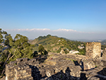
kangravalleybengali : "কাংড়া ভ্যালিঃ- মুখবন্ধ:-কাংড়া বিশ্বের প্রাচীনতম বেঁচে থাকা রাজবংশগুলোর মধ্যে একটা কাটোচ রাজবংশের আবাস বলে গর্বিত। রাজ্যের পশ্চিমাঞ্চলে বিস্তৃত কাংড়া হিমাচল প্রদেশের সবচেয়ে বড় অঞ্চল। মহিমান্বিত ধৌলাধার পর্বতমালার ছায়ায়, উপত্যকাটাও সবচেয়ে বৈচিত্র্যময় এবং মনোরম বলে খ্যাত। এখানকার মানুষজন অত্যন্ত ভদ্র, নম্র, পরিশ্রমী এবং অত্যন্ত অতিথিপরায়ণ। কাংড়ার নথিভুক্ত ইতিহাস ৩,৫০০ বছরেরও বেশি পুরনো। এই এলাকা সমৃদ্ধশালী হওয়ার জন্যে, অনেক আক্রমণের সাক্ষী, কিন্তু কাংড়ার কৌশলগত অবস্থান ও শক্তিশালী দুর্গ তাকার কারণে, বেশিরভাগ আক্রমণকারীদের পরিকল্পনা নস্যাৎ হয়ে যায়। ১৬১৫ সালে এই দুর্গ সম্রাট আকবরের মুঘল সৈন্যদের অবরোধকেও প্রতিরোধ করে। দুর্গটা এত মজবুত ছিল যে গত হাজার বছরের ইতিহাসে দুর্গের প্রতিরক্ষার উন্নয়নের জন্যে খুবই কম রক্ষণাবেক্ষণ করা হয়েছিল। সপ্তদশ শতাব্দীতে মুঘল সাম্রাজ্যের পতনের পর এই সৌন্দর্যমণ্ডিত ভূখণ্ড কলাশিল্প ও শিল্পীদের আশ্রয় দিয়েছিল যারা রাজদরবার থেকে পালিয়ে এসেছিল। স্থানীয় শিল্পকলার সংশ্লেষণ বিখ্যাত কাংড়া স্কুল অফ পেন্টিং এর জন্ম দিয়েছে। এই অনন্য শিল্প শৈলীর সেরা শিল্পকর্মগুলো বিশ্বের অনেক নামী গ্যালারিতে প্রদর্শিত হয়। সিমলা-মাতাউর জাতীয় মহাসড়ক থেকে কাংড়া শহরের আসার রাস্তায় দেখা যায়, পর্বতমালার উচ্চ সমতলভূমিতে অবস্থিত কাংড়া ফোর্ট ও স্রোতস্বিনী বানগঙ্গা নদীর নিম্ন উপত্যকার গভীরে অনন্যসুন্দর সবুজের ঘেরাটোপে লুকিয়ে থাকা অপূর্ব দৃশ্য। ইতিহাসের টাইমলাইনের দিকে একটু ফিরে মনঃসংযোগ করলে পাওয়া যাবে এক আনন্দ মিশ্রিত বিস্ময়ের অনুভূতি যা সত্যিই বিরল। কাংড়া হিমাচল প্রদেশের একটা বিখ্যাত জেলা যা ধরমশালা সহ রাজ্যের মূল প্রশাসনিক সদর দফতর। এটা দেবতাদের দেশ হিসেবে পরিচিত ও বিয়াস নদী কাংড়া উপত্যকার মধ্য দিয়ে প্রবাহিত হয়েছে। প্রাচীন মন্দির এবং চা বাগানের মনোমুগ্ধকর শোভার সাথে ধৌলাধার রেঞ্জের অপার সৌন্দর্যের বৈভব সবার দৃষ্টি কেড়ে নেয়। কাংড়া পরিদর্শনের সর্বোত্তম সময় হল মার্চ থেকে জুন মাস যখন এখানকার তাপমাত্রা মাঝারি থাকে এবং সন্ধেবেলা ঠাণ্ডা বাতাস বইতে থাকে। তুষারপ্রেমীরা ডিসেম্বর থেকে ফেব্রুয়ারি মাস পর্যন্ত আসেন। কাংড়ায় দেখার মতো জায়গাঃ- কাংড়া দুর্গঃ-এটা কাংড়া শহর থেকে ২ কিমি দূরে অবস্থিত যা বিয়াস নদী এবং তার উপনদীগুলির নিম্ন উপত্যকায় অবস্থান করছে। বৈজনাথ মন্দিরঃ-হিমাচল প্রদেশ পবিত্র বৈজনাথ মন্দিরের জন্য বিখ্যাত যা একটা অন্যতম জনপ্রিয় তীর্থস্থান। কাংড়া থেকে ৩৬ কিমি দূরে অবস্থিত হলেও কাংড়ায় দর্শনীয় স্থান দেখার ক্ষেত্রে এটা এক নম্বর স্থান অধিকার করে। ব্রজেশ্বরী মন্দিরঃ-কাংড়ার অন্যতম জনপ্রিয় আধ্যাত্মিক স্থান যেখানে প্রতি বছর প্রচুর পর্যটকের সমাগম হয়। এটা হিমাচলবাসীদের একটা অত্যন্ত পবিত্র তীর্থস্থান। কারেরি হ্রদঃ-এটা একটা অগভীর জলাশয় যার স্বচ্ছ এবং বিশুদ্ধ জল ধৌলাধার রেঞ্জ থেকে উৎপন্ন হয় ও শহরের মূল কেন্দ্র থেকে ২৫ কিমি দূরে অবস্থিত। চামুণ্ডা দেবী মন্দিরঃ-এটা কাংড়ার সবচেয়ে বিখ্যাত ও সবচেয়ে বেশি পর্যটক এই মন্দির দর্শন করেন। এখানে হিন্দু দেবতা, হনুমান ও ভৈরবের মন্দির এবং দেবদেবীর ক্রোধরূপী মূর্তির জন্য নিবেদিত। জ্বালা দেবী মন্দিরঃ-ভারতের আরেকটা অত্যন্ত বিখ্যাত ধর্মীয় স্থান যা প্রায়ই হিন্দু ধর্মাবলম্বীরা পরিদর্শন করেন। এই স্থান ৫১টা শক্তিপীঠর একটা। "+
"Read More..."+
"
"+
"শব্দঃ প্রতিবেদনঃ "+
""+
"ভিডিও"+
"স্লাইডশোর জন্যে নীচের ছবিতে ক্লিক করুন "+
"
"+
"পেজ মেনুতে যান",
kangravalleyenglish : "Kangra Valley:- Foreword:-Kangra is proud to be the abode of the Katoch dynasty, one of the oldest surviving dynasties in the world. Kangra is the largest region of Himachal Pradesh in the western part of the state. In the shadow of the majestic Dhauladhar mountains, the valley is also known to be the most diverse and picturesque. The people here are very polite, humble, hardworking and immensely hospitable. The recorded history of Kangra is more than 3,500 years old. The area has witnessed many invasions for its prosperity, but due to Kangra's strategic position and strong fortifications, most of the invaders' plans were thwarted. The fort also resisted the siege of Emperor Akbar's Mughal army in 1615. The fort was so strong that in the history of the last thousand years, very little maintenance was done to develop the fort's defenses. After the fall of the Mughal Empire in the seventeenth century, this beautiful land sheltered art and artists who had fled from the royal court. The synthesis of local art gave birth to the famous Kangra School of Painting. The best art works of unique style are displayed in many famous galleries around the world. On the way from the Shimla-Mataur National Highway to the town of Kangra, one can see the Kangra Fort in the high plains of the mountains and the magnificent greenery hidden in the depths of the lower valleys of the flowing river Banganga. A closer look at the timeline of history reveals a feeling of wonder mixed with joy which is really rare. Kangra is a famous district in Himachal Pradesh which is the main administrative headquarters of the state including Dharamsala. It is known as the land of the gods and the river Beas flows through the Kangra valley. The enchanting decoration of the ancient temples and tea gardens captures the splendour of the Dhauladhar range. The best time to visit Kangra is from March to June, when temperatures are moderate and cold winds blow in the evening. Snow lovers come from December to February. Places to see in Kangra:- Kangra Fort:-It is located at a distance of 2 km from Kangra town in the lower valley of Beas river and its tributaries. Baijnath Temple:-Himachal Pradesh is famous for its sacred Baijnath Temple which is one of the most popular pilgrimage sites. Although it is located at a distance of 36 km from Kangra, it is the number one tourist destination in Kangra. Brajeshwari Temple:-It is one of the most popular spiritual places of Kangra where a large number of tourists visit every year. It is a very sacred place of pilgrimage for the people of Himachal. Lake Carey:-It is a shallow body of water whose clear and pure water originates from the Dhauladhara range and is located at a distance of 25 km from the city centre. Chamunda Devi Temple:-This is the most famous and most visited temple in Kangra. The temple is dedicated Hindu deities, Hanuman and Bhairab, and to the raging idols of gods and goddesses. Jawala Devi Temple:-It is another very famous religious site in India which is frequently visited by Hindus. This place is one of the 51 Shakti Peethas. "+
"Read More..."+
"
"+
"Sound Stream: "+
""+
"ভিডিও"+
"Click any Picture for Slide Show "+
"
 "+
"
"+
" "+
"
"+
" "+
"
"+
" "+
"
"+
" "+
"
"+
" "+
"
"+
" "+
"
"+
" "+
"
"+
" "+
"
"+
" "+
"
"+
" "+
"
"+
" "+
"
"+
" "+
"
"+
" "+
"
"+
" "+
"
"+
" "+
"",
dharamsalabengali : "ধরমশালাঃ-মুখবন্ধঃ-সুবিশাল ধৌলাধার রেঞ্জের ছায়ায় শুয়ে থাকা ধরমশালা এক বিচিত্র শহর। এই শহর দুটো ভাগে বিভক্ত। কোতোয়ালি বাজার এবং ব্যস্ত বাজারগুলো নিয়ে তৈরি হয়েছে নিম্ন বা লোয়ার ধরমশালা ও ম্যাক্লিওডগঞ্জ শহরের চারপাশে ঘন পাইন, দেবদারু এবং ওক বনের উপরিভাগে এক নাটকীয় মঞ্চে তৈরি হয়েছে উচ্চ বা আপার ধরমশালা। কাংড়া থেকে ক্রমাগত ১৮ কিমি চড়াই পথে পৌঁছনো যায় ধরমশালায়। ম্যাক্লিওডগঞ্জ, নির্বাসিত তিব্বত সরকারের রাজধানী হিসেবে কাজ করে। ক্রমবর্ধমান উচ্চতার সাথে, নিম্ন এবং উচ্চ ধরমশালার মধ্যে গ্রীষ্মের তাপমাত্রা উষ্ণ থেকে শীতল জলবায়ুতে পরিবর্তিত হয়। ১৯৫৯ সালের তিব্বত বিদ্রোহের পরিপ্রেক্ষিতে পবিত্র ১৪তম দালাই লামা, লাসা থেকে পালিয়ে এখানে এসেছিলেন। নির্বাসনে থাকার জন্যে ম্যাক্লিওডগঞ্জকে বেছে নেওয়ার ফলে, তিব্বতি জনসংখ্যার একটি বড় অংশ এখানে চলে এসেছিল। প্রায়শই লিটল লাসা নামে পরিচিত এই শহরের প্রাণবন্ত চরিত্রটা আজ সারা বিশ্বের বিভিন্ন দেশের প্রধান, চলচ্চিত্র নির্মাতা এবং কূটনীতিক সহ অনেক বিখ্যাত ব্যক্তিদের ধরমশালার ম্যাক্লিওডগঞ্জকে আকর্ষণ করে। ঔপনিবেশিক প্রভাবের ছাপ শহরে ও শহরতলীতে আজও অক্ষত রয়েছে যা চারপাশে ছড়িয়ে ছিটিয়ে থাকা ভবন, গির্জা এবং সে যুগের অন্যান্য নিদর্শনগুলিতে দেখা যায়। পর্যটন, ব্যবসা ও চাকরির সঙ্গে যুক্ত মানুষজন হিন্দি, পাঞ্জাবি, ইংরেজি ভাষা বোঝে এবং কথা বলে। আদিবাসীরা কাংড়ি ভাষায় কথা বলে এবং বৌদ্ধ সম্প্রদায়ের মানুষজন তিব্বতি ভাষায় কথা বলে।ম্যাক্লিওডগঞ্জ হলো ধরমশালা পরিদর্শনের অন্যতম আকর্ষণ। তিব্বতি সম্প্রদায় দ্বারা অধ্যুষিত, ২,০৮২ মিটার উচ্চতায় অবস্থিত শহরতলীকে মিনি লাসা হিসেবেও উল্লেখ করা হয়। ম্যাক্লিওডগঞ্জের প্রধান রাস্তায় তিব্বতি কারুশিল্পের দোকান এবং খাবারের দোকানে ভর্তি যেখানে তিব্বতি রান্নার গন্ধ পাওয়া যায় ও রান্না করা তাজা এবং সুস্বাদু খাবার হোটেলে মেলে। বাজারের প্রধান অংশটা সুগলোগ খাং মন্দিরের চারপাশে কেন্দ্রীভূত।ইতিহাসঃ-ধরমশালা এবং আশেপাশের অঞ্চলগুলো প্রায় ২০০০ সাল ধরে কাংড়ার কাটোচ রাজবংশের একটি অংশ ছিল। ভারতে ব্রিটিশ শাসন আসার সাথে সাথে ধরমশালা পাঞ্জাব প্রদেশের একটি অংশ হয়ে ওঠে। আমরা আজকে যে ধরমশালা শহর দেখতে পাই তা প্রথম ধৌলাধার পাহাড়ের ঢালে একটা অভয়ারণ্যের কাছে প্রথম গোর্খা রাইফেলসের বসতির মাধ্যমে তৈরি হয়েছিল। অভয়ারণ্যের নামটা হিন্দু পৌরাণিক নাম থেকে নেওয়া হয়েছে বলে এখানকার নাম ধরমশালা হিসেবে প্রথম ব্যবহৃত হয়। কিন্তু গোর্খারা ভাগসুনাগের প্রাচীন শিব মন্দিরে উপাসনা করার কারণে এই অঞ্চলকে ভাগসুও বলা হয়। এই শহর ব্রিটিশদের জন্যে একটা জনপ্রিয় গ্রীষ্মকালীন অবকাশের স্থানও ছিল। তারপর আসে ১৯০৫ সালের ৭.৮ রিক্টার স্কেলের বিধ্বংসী ভূমিকম্প। ভূমিকম্পে ভাগসুনাগ মন্দির সহ সেনানিবাসের বেশিরভাগ অংশ ধ্বংস হয়ে যায়। গোর্খারা পরে শহর এবং মন্দির পুনর্নির্মাণ করে, যা প্রথম গোর্খা রাইফেলস হেরিটেজ হিসাবে পরিচিত হয়। কিন্তু এই সময় থেকে, ১৯৫৯ সালে দালাই লামা এবং তিব্বতি উদ্বাস্তুদের আগমন না হওয়া পর্যন্ত ধর্মশালার জনপ্রিয়তা হ্রাস পায়। আজ, এই শহর ভারতীয় এবং তিব্বতিদের একটি বন্ধুত্বপূর্ণ মিশ্রণ, উভয়েরই ধর্মশালার লিগ্যাসিতে অবদান আছে।দর্শনীয় স্থানগুলোঃ-ধরমকোটঃ-ম্যাক্লিওডগঞ্জ থেকে ধরমকোট যেতে হয় চড়াই পথে। উচ্চতা বাড়ার সাথে সাথে প্রাকৃতিক দৃশ্যগুলো আরও বিস্তৃত ও মনোরম হয়। ধরমকোট অনেক বিদেশীর আবাসস্থল এবং এই ছোট গ্রামের জীবন পশ্চিমী জীবনধারা দ্বারা প্রভাবিত। এই গ্রামটা ত্রিউন্ডে ট্রেক করার জন্য একটা বেস ক্যাম্প বলা যেতে পারে ও পর্বতমালার ওপরে একটি মনোরম চারণভূমি।সেন্ট জন চার্চঃ-সেন্ট জন চার্চ ইন দি ওয়াইল্ডারনেস, ব্রিটিশ রাজের এক নিদর্শন। নিও-গাথিক স্থাপত্য শৈলীতে নির্মিত এই চার্চ, ১৮৫২ সালে নির্মিত হয়েছিল এবং এটা ফোরসাইথ গঞ্জের কাছে একটা জঙ্গলে অবস্থিত। ১৯০৫ সালের বিধ্বংসী ভূমিকম্পে, যেখানে কাংড়া উপত্যকার বেশিরভাগ বিল্ডিং ধূলিসাৎ হয়ে গেছিল, সেখানে এই চার্চের ক্ষতি খুবই কম হয়েছিল। এর কম্পাউন্ডের মধ্যে ১৮৬২ থেকে ১৮৬৩ সালের ব্রিটিশ রাজপ্রতিনিধি লর্ড এলগিনকে সমাহিত করা হয়েছে। চার্চে কিছু সূক্ষ্ম বেলজিয়াম কাঁচের সুন্দর কাজযুক্ত কিছু গ্লাস জানালা রয়েছে।কাংড়া আর্ট মিউজিয়ামঃ-কোতোয়ালি বাজারের কাংড়া আর্ট মিউজিয়ামটাও খুব সুন্দর। এখানে কাংড়া উপত্যকা এবং তিব্বতি সংস্কৃতির শিল্প ও ইতিহাসের অনেক সুন্দর সুন্দর প্রায় দেড় হাজারেরও বেশি প্রত্নবস্তু এবং কারুশিল্পের নিদর্শন পাওয়া যায় যার মধ্যে কিছু কিছু পঞ্চম শতাব্দীর নিদর্শন। এখানে ক্ষুদ্র চিত্রকর্মের একটা সূক্ষ্ম সংগ্রহও রয়েছে। সংগ্রহের মধ্যে মূর্তি, মৃৎশিল্প এবং নৃতাত্ত্বিক জিনিসপত্র উল্লেখযোগ্য।ওয়ার মেমোরিয়ালঃ-ধরমশালার গেটওয়েতে সুন্দরভাবে সাজানো বাগান সহ একটা সুন্দর পাইন বনের মধ্যে রয়েছে ওয়ার মেমোরিয়াল। এটা একটা স্মৃতিসৌধ যা জাতির সেবায় মারা যাওয়া সৈনিকদের প্রতি শ্রদ্ধা জানায়।নরবুলিংকা ইনস্টিটিউটঃ-ধরমশালা থেকে সাত কিমি দূরে অবস্থিত নরবুলিংকা ইনস্টিটিউটের প্রাণবন্ত তিব্বতি স্থাপত্য পর্যটকদের আকর্ষণ করে। এই ইনস্টিটিউট জাপানি স্টাইলের বাগানের মধ্যে বিশাল এলাকা নিয়ে দাঁড়িয়ে আছে। গাছগাছালিতে ভরা জঙ্গলে পাখির ডাক ও চতুর্দিকে ছড়িয়ে ছিটিয়ে থাকা যুদ্ধাস্ত্রের প্রতীক দেখতে বেশ ভাল লাগে। কেলসাং এবং কিম ইয়েশি, তিব্বতের শিল্প, কারুশিল্প এবং সংস্কৃতি সংরক্ষণের জন্যে, ১৯৯৫ সালে এটা প্রতিষ্ঠা করেন।গিউতো মঠঃ-ধরমশালার কাছে সিধওয়ারীতে গিউতো মঠ, নির্বাসনে থাকা একজন অত্যন্ত শ্রদ্ধেয় তিব্বতি লামার বাসস্থান। অনেক তিব্বতি উদ্বাস্তু এবং বিদেশী পর্যটক এই মঠ পরিদর্শন করেন।কুণাল পাথরি মন্দিরঃ-ধরমশালা থেকে মাত্র তিন কিমি দূরে কুণাল পাথরিতে একটা ছোট মন্দির আছে যেখানে দেবী দুর্গা কপালেশ্বরী নামে পূজিত হন।ভাগসুনাগ মন্দির ও জলপ্রপাতঃ-ভাগসুনাগ মন্দির হয়ে জলপ্রপাতে যাওয়া যায়। এই প্রাকৃতিক জলপ্রপাত তীর্থযাত্রী এবং পর্যটকদের কাছে অত্যন্ত আকর্ষণের ও অসম্ভব সুন্দর। বর্ষাকালে এর রূপ পূর্ণযৌবনা হয়ে যায়। ভাগসুনাগ মন্দির একটা জলের ঝরনার ওপর নির্মিত। পৌরাণিক কাহিনী অনুযায়ী, এই মন্দির অসুর রাজা ভাগসু ও সাপের দেবতা নাগের মধ্যে একটি চুক্তির স্মৃতিচারণ করে। যুদ্ধবিরতির শর্ত অনুযায়ী, রাক্ষসের শুকনো জমিতে সেচ দেওয়ার জন্যে, সর্প দেবতা তার ভূগর্ভস্থ রাজ্যের জল ব্যবহার অনুমতি দেন। এই জল একটা পুকুরে গিয়ে পড়ে ও তীর্থযাত্রীরা সেখানে স্নান করে পুজো দেন। ভাগসুনাগ ওয়াটার ফলস, ম্যাক্লিওডগঞ্জ থেকে মাত্র দু কিমি দূরে অবস্থিত।এ ছাড়াও চার কিমি দূরের ডাল লেক, ৯ কিমি দূরে ২,৯৩৭ মিটার উচ্চতায় অবস্থিত কারেরি হ্রদ খুবই সুন্দর। ধরমশালার ধরমকোট গ্রামের কাছে গালু দেবী মন্দির থেকে ৪,৩৪২ মিটার উচ্চতায় অবস্থিত একটা হাই অলটিচিউড ট্রেক, ইন্দ্রহার পাস যাওয়া যায়। ইন্দ্রহার পাস এপ্রিল থেকে অক্টোবর পর্যন্ত খোলা থাকে। পাস থেকে ধৌলাধার, পীর পাঞ্জাল পর্বত এবং আর্থার আসনের দৃশ্য খুব সুন্দর লাগে। "+
"Read More..."+
"
"+
"",
dharamsalabengali : "ধরমশালাঃ-মুখবন্ধঃ-সুবিশাল ধৌলাধার রেঞ্জের ছায়ায় শুয়ে থাকা ধরমশালা এক বিচিত্র শহর। এই শহর দুটো ভাগে বিভক্ত। কোতোয়ালি বাজার এবং ব্যস্ত বাজারগুলো নিয়ে তৈরি হয়েছে নিম্ন বা লোয়ার ধরমশালা ও ম্যাক্লিওডগঞ্জ শহরের চারপাশে ঘন পাইন, দেবদারু এবং ওক বনের উপরিভাগে এক নাটকীয় মঞ্চে তৈরি হয়েছে উচ্চ বা আপার ধরমশালা। কাংড়া থেকে ক্রমাগত ১৮ কিমি চড়াই পথে পৌঁছনো যায় ধরমশালায়। ম্যাক্লিওডগঞ্জ, নির্বাসিত তিব্বত সরকারের রাজধানী হিসেবে কাজ করে। ক্রমবর্ধমান উচ্চতার সাথে, নিম্ন এবং উচ্চ ধরমশালার মধ্যে গ্রীষ্মের তাপমাত্রা উষ্ণ থেকে শীতল জলবায়ুতে পরিবর্তিত হয়। ১৯৫৯ সালের তিব্বত বিদ্রোহের পরিপ্রেক্ষিতে পবিত্র ১৪তম দালাই লামা, লাসা থেকে পালিয়ে এখানে এসেছিলেন। নির্বাসনে থাকার জন্যে ম্যাক্লিওডগঞ্জকে বেছে নেওয়ার ফলে, তিব্বতি জনসংখ্যার একটি বড় অংশ এখানে চলে এসেছিল। প্রায়শই লিটল লাসা নামে পরিচিত এই শহরের প্রাণবন্ত চরিত্রটা আজ সারা বিশ্বের বিভিন্ন দেশের প্রধান, চলচ্চিত্র নির্মাতা এবং কূটনীতিক সহ অনেক বিখ্যাত ব্যক্তিদের ধরমশালার ম্যাক্লিওডগঞ্জকে আকর্ষণ করে। ঔপনিবেশিক প্রভাবের ছাপ শহরে ও শহরতলীতে আজও অক্ষত রয়েছে যা চারপাশে ছড়িয়ে ছিটিয়ে থাকা ভবন, গির্জা এবং সে যুগের অন্যান্য নিদর্শনগুলিতে দেখা যায়। পর্যটন, ব্যবসা ও চাকরির সঙ্গে যুক্ত মানুষজন হিন্দি, পাঞ্জাবি, ইংরেজি ভাষা বোঝে এবং কথা বলে। আদিবাসীরা কাংড়ি ভাষায় কথা বলে এবং বৌদ্ধ সম্প্রদায়ের মানুষজন তিব্বতি ভাষায় কথা বলে।ম্যাক্লিওডগঞ্জ হলো ধরমশালা পরিদর্শনের অন্যতম আকর্ষণ। তিব্বতি সম্প্রদায় দ্বারা অধ্যুষিত, ২,০৮২ মিটার উচ্চতায় অবস্থিত শহরতলীকে মিনি লাসা হিসেবেও উল্লেখ করা হয়। ম্যাক্লিওডগঞ্জের প্রধান রাস্তায় তিব্বতি কারুশিল্পের দোকান এবং খাবারের দোকানে ভর্তি যেখানে তিব্বতি রান্নার গন্ধ পাওয়া যায় ও রান্না করা তাজা এবং সুস্বাদু খাবার হোটেলে মেলে। বাজারের প্রধান অংশটা সুগলোগ খাং মন্দিরের চারপাশে কেন্দ্রীভূত।ইতিহাসঃ-ধরমশালা এবং আশেপাশের অঞ্চলগুলো প্রায় ২০০০ সাল ধরে কাংড়ার কাটোচ রাজবংশের একটি অংশ ছিল। ভারতে ব্রিটিশ শাসন আসার সাথে সাথে ধরমশালা পাঞ্জাব প্রদেশের একটি অংশ হয়ে ওঠে। আমরা আজকে যে ধরমশালা শহর দেখতে পাই তা প্রথম ধৌলাধার পাহাড়ের ঢালে একটা অভয়ারণ্যের কাছে প্রথম গোর্খা রাইফেলসের বসতির মাধ্যমে তৈরি হয়েছিল। অভয়ারণ্যের নামটা হিন্দু পৌরাণিক নাম থেকে নেওয়া হয়েছে বলে এখানকার নাম ধরমশালা হিসেবে প্রথম ব্যবহৃত হয়। কিন্তু গোর্খারা ভাগসুনাগের প্রাচীন শিব মন্দিরে উপাসনা করার কারণে এই অঞ্চলকে ভাগসুও বলা হয়। এই শহর ব্রিটিশদের জন্যে একটা জনপ্রিয় গ্রীষ্মকালীন অবকাশের স্থানও ছিল। তারপর আসে ১৯০৫ সালের ৭.৮ রিক্টার স্কেলের বিধ্বংসী ভূমিকম্প। ভূমিকম্পে ভাগসুনাগ মন্দির সহ সেনানিবাসের বেশিরভাগ অংশ ধ্বংস হয়ে যায়। গোর্খারা পরে শহর এবং মন্দির পুনর্নির্মাণ করে, যা প্রথম গোর্খা রাইফেলস হেরিটেজ হিসাবে পরিচিত হয়। কিন্তু এই সময় থেকে, ১৯৫৯ সালে দালাই লামা এবং তিব্বতি উদ্বাস্তুদের আগমন না হওয়া পর্যন্ত ধর্মশালার জনপ্রিয়তা হ্রাস পায়। আজ, এই শহর ভারতীয় এবং তিব্বতিদের একটি বন্ধুত্বপূর্ণ মিশ্রণ, উভয়েরই ধর্মশালার লিগ্যাসিতে অবদান আছে।দর্শনীয় স্থানগুলোঃ-ধরমকোটঃ-ম্যাক্লিওডগঞ্জ থেকে ধরমকোট যেতে হয় চড়াই পথে। উচ্চতা বাড়ার সাথে সাথে প্রাকৃতিক দৃশ্যগুলো আরও বিস্তৃত ও মনোরম হয়। ধরমকোট অনেক বিদেশীর আবাসস্থল এবং এই ছোট গ্রামের জীবন পশ্চিমী জীবনধারা দ্বারা প্রভাবিত। এই গ্রামটা ত্রিউন্ডে ট্রেক করার জন্য একটা বেস ক্যাম্প বলা যেতে পারে ও পর্বতমালার ওপরে একটি মনোরম চারণভূমি।সেন্ট জন চার্চঃ-সেন্ট জন চার্চ ইন দি ওয়াইল্ডারনেস, ব্রিটিশ রাজের এক নিদর্শন। নিও-গাথিক স্থাপত্য শৈলীতে নির্মিত এই চার্চ, ১৮৫২ সালে নির্মিত হয়েছিল এবং এটা ফোরসাইথ গঞ্জের কাছে একটা জঙ্গলে অবস্থিত। ১৯০৫ সালের বিধ্বংসী ভূমিকম্পে, যেখানে কাংড়া উপত্যকার বেশিরভাগ বিল্ডিং ধূলিসাৎ হয়ে গেছিল, সেখানে এই চার্চের ক্ষতি খুবই কম হয়েছিল। এর কম্পাউন্ডের মধ্যে ১৮৬২ থেকে ১৮৬৩ সালের ব্রিটিশ রাজপ্রতিনিধি লর্ড এলগিনকে সমাহিত করা হয়েছে। চার্চে কিছু সূক্ষ্ম বেলজিয়াম কাঁচের সুন্দর কাজযুক্ত কিছু গ্লাস জানালা রয়েছে।কাংড়া আর্ট মিউজিয়ামঃ-কোতোয়ালি বাজারের কাংড়া আর্ট মিউজিয়ামটাও খুব সুন্দর। এখানে কাংড়া উপত্যকা এবং তিব্বতি সংস্কৃতির শিল্প ও ইতিহাসের অনেক সুন্দর সুন্দর প্রায় দেড় হাজারেরও বেশি প্রত্নবস্তু এবং কারুশিল্পের নিদর্শন পাওয়া যায় যার মধ্যে কিছু কিছু পঞ্চম শতাব্দীর নিদর্শন। এখানে ক্ষুদ্র চিত্রকর্মের একটা সূক্ষ্ম সংগ্রহও রয়েছে। সংগ্রহের মধ্যে মূর্তি, মৃৎশিল্প এবং নৃতাত্ত্বিক জিনিসপত্র উল্লেখযোগ্য।ওয়ার মেমোরিয়ালঃ-ধরমশালার গেটওয়েতে সুন্দরভাবে সাজানো বাগান সহ একটা সুন্দর পাইন বনের মধ্যে রয়েছে ওয়ার মেমোরিয়াল। এটা একটা স্মৃতিসৌধ যা জাতির সেবায় মারা যাওয়া সৈনিকদের প্রতি শ্রদ্ধা জানায়।নরবুলিংকা ইনস্টিটিউটঃ-ধরমশালা থেকে সাত কিমি দূরে অবস্থিত নরবুলিংকা ইনস্টিটিউটের প্রাণবন্ত তিব্বতি স্থাপত্য পর্যটকদের আকর্ষণ করে। এই ইনস্টিটিউট জাপানি স্টাইলের বাগানের মধ্যে বিশাল এলাকা নিয়ে দাঁড়িয়ে আছে। গাছগাছালিতে ভরা জঙ্গলে পাখির ডাক ও চতুর্দিকে ছড়িয়ে ছিটিয়ে থাকা যুদ্ধাস্ত্রের প্রতীক দেখতে বেশ ভাল লাগে। কেলসাং এবং কিম ইয়েশি, তিব্বতের শিল্প, কারুশিল্প এবং সংস্কৃতি সংরক্ষণের জন্যে, ১৯৯৫ সালে এটা প্রতিষ্ঠা করেন।গিউতো মঠঃ-ধরমশালার কাছে সিধওয়ারীতে গিউতো মঠ, নির্বাসনে থাকা একজন অত্যন্ত শ্রদ্ধেয় তিব্বতি লামার বাসস্থান। অনেক তিব্বতি উদ্বাস্তু এবং বিদেশী পর্যটক এই মঠ পরিদর্শন করেন।কুণাল পাথরি মন্দিরঃ-ধরমশালা থেকে মাত্র তিন কিমি দূরে কুণাল পাথরিতে একটা ছোট মন্দির আছে যেখানে দেবী দুর্গা কপালেশ্বরী নামে পূজিত হন।ভাগসুনাগ মন্দির ও জলপ্রপাতঃ-ভাগসুনাগ মন্দির হয়ে জলপ্রপাতে যাওয়া যায়। এই প্রাকৃতিক জলপ্রপাত তীর্থযাত্রী এবং পর্যটকদের কাছে অত্যন্ত আকর্ষণের ও অসম্ভব সুন্দর। বর্ষাকালে এর রূপ পূর্ণযৌবনা হয়ে যায়। ভাগসুনাগ মন্দির একটা জলের ঝরনার ওপর নির্মিত। পৌরাণিক কাহিনী অনুযায়ী, এই মন্দির অসুর রাজা ভাগসু ও সাপের দেবতা নাগের মধ্যে একটি চুক্তির স্মৃতিচারণ করে। যুদ্ধবিরতির শর্ত অনুযায়ী, রাক্ষসের শুকনো জমিতে সেচ দেওয়ার জন্যে, সর্প দেবতা তার ভূগর্ভস্থ রাজ্যের জল ব্যবহার অনুমতি দেন। এই জল একটা পুকুরে গিয়ে পড়ে ও তীর্থযাত্রীরা সেখানে স্নান করে পুজো দেন। ভাগসুনাগ ওয়াটার ফলস, ম্যাক্লিওডগঞ্জ থেকে মাত্র দু কিমি দূরে অবস্থিত।এ ছাড়াও চার কিমি দূরের ডাল লেক, ৯ কিমি দূরে ২,৯৩৭ মিটার উচ্চতায় অবস্থিত কারেরি হ্রদ খুবই সুন্দর। ধরমশালার ধরমকোট গ্রামের কাছে গালু দেবী মন্দির থেকে ৪,৩৪২ মিটার উচ্চতায় অবস্থিত একটা হাই অলটিচিউড ট্রেক, ইন্দ্রহার পাস যাওয়া যায়। ইন্দ্রহার পাস এপ্রিল থেকে অক্টোবর পর্যন্ত খোলা থাকে। পাস থেকে ধৌলাধার, পীর পাঞ্জাল পর্বত এবং আর্থার আসনের দৃশ্য খুব সুন্দর লাগে। "+
"Read More..."+
" "+
"
"+
" "+
"
"+
" "+
"
"+
" "+
"
"+
" "+
"
"+
" "+
"
"+
" "+
"",
kangravalleybengali : "কাংড়া ভ্যালিঃ-
"+
"",
kangravalleybengali : "কাংড়া ভ্যালিঃ- "+
"
"+
" "+
"
"+
" "+
"
"+
" "+
"
"+
" "+
"
"+
" "+
"
"+
" "+
"
"+
" "+
"",
headingbengali : "হিমাচল প্রদেশ",
headingenglish : "HIMACHAL PRADESH",
};
"+
"",
headingbengali : "হিমাচল প্রদেশ",
headingenglish : "HIMACHAL PRADESH",
};